SierraScape June-July 2005
Back to Table of Contents
by Gail Shorney


|
On March 28, 2005, one of the most beautiful natural resources in Jefferson County, Missouri was destroyed to accommodate a planned development.
The residents of Springbrook Farm awoke to "no trespassing" signs that graced what once had been their back yards. The signs warned them to stay away from the beautiful two acre spring fed lake that had been so lovingly maintained and cared for by them over twenty years.
Four days prior to the lake's demise, E & M Development's preliminary plat was denied by the Planning and Zoning Commissioners of Jefferson County for a second time. The developers plan was denied based on lot design standards, suitability of the site based on topography, elimination of natural resources and street plans. There were other issues about health and safety of existing residents during construction but the major concern was the unnecessary destruction of a two acre spring fed lake on which the developer planned to build homes.
The lake is from one to two acres in size depending on the storm water run-off and water tables. It is established on the U.S. Geological Survey Map in the Herculaneum Quadrangle as a self sustaining lake fed by permanent seeper springs that leak from the ridge that surrounds the area. The springs found under the lake will be capped and the area filled in order to build houses.
The residents of Springbrook Farm have never been against a responsible development. It has always been their hope that a developer would appreciate the outstanding beauty of the natural resources and use the lake and woods to enhance the sale-ability of their homes. With the help of the Department of Conservation, a cluster design to utilize the existing environmental beauty would ensure the sale of homes in an area that projects over 1000 houses completed before 2007. The residents feel that the destruction of the natural resources is unnecessary and unreasonable.
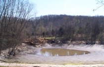
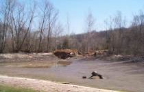
On March 29, 2005, the storm water retention dam that held the lake was destroyed. The fish contained within the lake were released into the land behind the dam. The release caused flooding of roads and land in the area, running across the property of a factory that was once protected from storm water run-off. Workers with fireworks, seining nets, boats and spears killed the remaining fish in the lake while others waded waste deep to catch the fish in the backwater.
In the evening eight deer stood in a nearby yard staring longingly at the absence of the only water source for them in the area. A blue heron that had been a long-time resident circled above the mud hole for at least five minutes looking for what was once his home.
Alarmingly, the judgement of the commission to make a decision that does not favor a developer is being legally questioned. A Writ of Mandamus suit was filed against the commission in September 2004. The commission not only has the right to deny a problematic plat but the responsibility to do so. They have a broad and comprehensive view of the issues and their responsibility is to enforce the statutes of the county, which includes the interest of the residents as well as the developers. This developer's engineer disagrees with the judgment of the Jefferson County Engineer. The county has requested that certain lots be designated as common ground because of proposed elevation between lots and proposed grading on slopes that would compromise the integrity of the shelves over existing homes in Bayberry Farm Subdivision. The County Storm Water Engineer discourages wholesale destruction of trees on steep slopes because of the degree of absorption that trees provide in poor soil conditions, but the developers engineer disagrees.
The Planning and Zoning Commission voted to deny the developers petition based on both Article II, General Information and Section 2.5, suitability of Land for subdivision or development; and Article V design Standards and Requirements for Improvements, Section 5.2, Lot Design Standards, namely the discussion included issues such as suitability of the site for platting, suitability of the site for building lots, and suitability related to topography, natural resources and streets. None of these issues have been addressed by the developers engineer to the satisfaction of the Commissioners.
The developer purchased an underlying plat dated 1965 before there was a Planning and Zoning Department in Jefferson County. As owner of the property he feels it is his to do with as he wishes. The current and underlying plat is not under the jurisdiction of the County. However, all permits required to make improvements will fall under the current building codes and standards of the County.
Every environmental protection agency has been alerted. Local representatives are aware of the situation. In the Jefferson County Journal on Wednesday, April 6, 2005, Mark Mertens, Presiding Commissioner in Jefferson County, said, "It seems to me that they could have sold those lots for a lot more with the lake than without." State Representative Jeff Roorda is working very hard to find upcoming bills for a way to revise statutes on development of a subdivision grandfathered under local P & Z Regulations, to avoid the wholesale destruction of natural resources in Jefferson County.
www.springbrookhistory.tkpcs.com