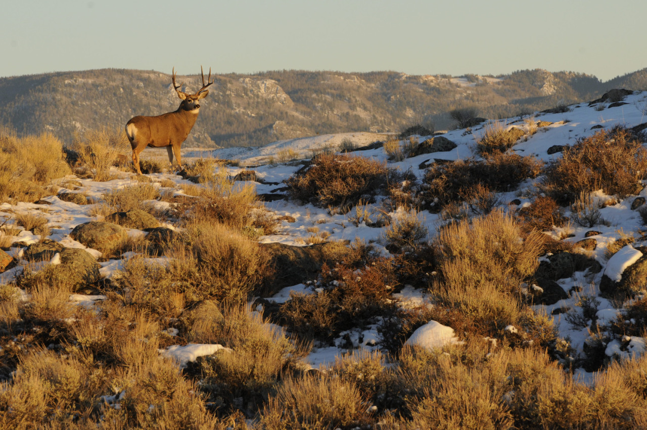
Huge tracts of public lands in Wyoming are national treasures with vast wild areas, incredible wildlife, spectacular scenery, and world-class recreational opportunities. As the public lands managers make decisions on how to manage these resources for future generations, the Wyoming Chapter helps make sure the natural values of these lands will be adequately protected for the future. You can help by joining our Public Lands Team.
Most of the public lands issues that the Sierra Club Wyoming Chapter (SCWC) are tackling currently involve lands in the western half of the state. Some of these are:
Bridger-Teton National Forest
The Wyoming Chapter is continually involved with Bridger-Teton National Forest plan and project reviews, environmental impact statements, and other forest management decisions. We are always striving to help the U.S. Forest Service (USFS) to make the right decisions to protect these public lands and the wildlife that live there.
Palisades Wilderness Study Area

The Palisades Wilderness Study Area (WSA) is a large tract of wilderness-quality lands lying south of Teton Pass Road, north of Snake River Canyon, west of the Fall Creek Road to the Wyoming/Idaho state line. The Sierra Club Wyoming Chapter (SCWC) has long advocated to maintain all the wilderness characteristics of Palisades WSA, and to promote it as a candidate for congressional wilderness designation under the Wilderness Act of 1964. Recent challenges to the wild integrity of Palisades include increasing winter snowmobile use, pressure from the USFS to use machinery to implement fuel reduction work, and incursions of mountain bike trails into the WSA. The Palisades WSA is also under scrutiny through the Wyoming Public Lands initiative process.
The Wyoming Chapter submitted extensive comments to the USFS on their fuels reduction draft environmental impact statement (DEIS):
DEIS on Teton to Snake (Palisades) Fuel Management Plan - SCWC Comments
Caribou-Targhee National Forest Southern Valley Recreation Project
Part of the proposed Southern Valley Recreation Project (Caribou–Targhee National Forest of southern Idaho) extends into the Palisades Wilderness Study Area in northwestern Wyoming. Please click here to see the Sierra Club’s comments regarding the proposed Southern Valley Recreation Project. Please contact Sierra Club Wyoming Chapter Conservation Director Lloyd Dorsey at lloyd.dorsey@sierraclub.org or 307-690-1967 if you have questions about these comments.
Other related articles:
Jackson Hole News and Guide, Letters to the Editor, July 13, 2016
Wyoming Range Victory!!

For years we have worked to protect the Wyoming Range, a pristine paradise for wildlife and recreational opportunity, from the ravages of industrialization. This is a landscape that harbors streams of Colorado River Cutthroat Trout, the largest moose herds in Wyoming, and big game birthing areas and migration routes. After years of battle, the Wyoming conservation community achieved a huge victory in the no-leasing decision made by USFS officials in late December 2016. About 40,000 acres of forest lands at the tops of three important Wyoming Range drainages was taken off the table for oil and gas development for the foreseeable future. Great work by the Chapter and its many conservation allies!
Another important Wyoming Range victory in 2016 was the retirement of seven sheep grazing allotments. The Wyoming Chapter is proud to have partnered with the National Wildlife Federation to achieve this important goal.
State-run Feed Grounds on BTNF Lands
The Wyoming Chapter is a leader in trying to eliminate artificial feeding of game herds during the winter on state-run feed grounds. Winter feeding is counter to all good wildlife management practices and amounts to seasonal domestication of our wildlife. Winter feeding is also very dangerous because of the great potential for disease transmission among concentrated wildlife. As the latest and always fatal wildlife disease, Chronic Wasting Disease, inches ever nearer to these feedlots, the Wyoming Chapter is fighting to end feeding in every avenue possible.
Grand Teton National Park (GTNP)
Grand Teton National Park is a crown jewel of our national park system. The unparalleled scenery and wildlife viewing makes this landscape the lifeblood of Jackson Hole, Wyoming. The Wyoming Chapter has long engaged in fighting for protections for this incredible place.
Moose Wilson Corridor
VICTORY!!! The final Record of Decision (ROD) came out in late 2016, and mostly agreed with the stance of the Sierra Club Wyoming Chapter. Our support was a big factor in allowing the U.S. Park Service to stand up against powerful interests, and resist efforts to make this quiet, small road into a major through-way, with huge impacts in this delicate landscape.
The Wyoming Chapter continues efforts to eliminate elk hunting in Grand Teton National Park. Ostensibly, the elk hunt in GTNP only exists because of the feeding program on the National Elk Refuge. Yet, the hunt does little to actually reduce the elk being fed. The hunt definitely increases hunter/grizzly bear encounters, sometimes with deadly results for the bears. For these reasons, the Wyoming Chapter will continue to advocate for the end of the Park elk hunt.
Soundscapes of the Moose-Wilson Corridor
Shoshone National Forest (SNF)

The Shoshone National Forest (SNF) is our nation's first national forest, and ranks high amoung the wildest. The Shoshone is home to hundreds of Yellowstone grizzly bears, several wolf packs, and a full complement of the wildlife of the greater Yellowstone ecosystem. Fifty-seven percent of the Shoshone is designated as wilderness.
The Shoshone National Forest management personnel completed their resource management plan (RMP) revision in early 2016. Sierra Club Wyoming Chapter members participated in dozens of meetings throughout that process, and submitted hundreds of comments, all in an effort to protect the Shoshone. While forest management personnel did not add any new wilderness recommendations to the RMP, the SCWC did achieve roadless protections for many important areas, and we forced clarity on wilderness-type protections for the Dunoir Special Management Unit.
Shoshone Travel Management Process
As soon as the Forest Service finalized their RMP, forest officials started on a travel management plan (TMP) for the Shoshone. The SCWC anticipated this and began collecting data on the Shoshone travel system beginning in 2014 as part of project titled Illegal Motorized Project (IMP). Since 2014, Chapter volunteers have inventoried many miles of illegal roads and motorized trails on the Forest. The IMP projected has already yielded three significant outcomes in our efforts to reduce motorized impacts on the Shoshone:
- Our data and well-informed volunteers have made it clear to the Forest Service that illegal motorized use is widespread, causes resource damage, and the Forest Service has not done a good job of protecting the Forest from illegal motorized use.
- The time spent inventorying illegal motorized use armed our volunteers with infomation to help them be effective advocates for protecting the Shoshone throughout the travel management process.
- Pressure applied by Chapter volunteers caused the Forest Service to convene a "Travel Compliance Summit" in February 2016 during which a committee of volunteers, the Compliance Working Group, was empowered by the Forest Service to make recommendations to help the Forest Service achieve travel rule compliance. The Sierra Club Wyoming Chapter had a seat at that table, and was instrumental in assuring that the recommendations were meaningful and, if implemented, would greatly improve travel rule compliance.
The SCWC volunteers working on the monitoring project observed significant improvements during the summer of 2016 in signage - an important first step to eliminating illegal motorized use.
The travel plan process included a scoping comment period in June of 2016, and the Chapter submitted general scoping comments and specific comments on proposed actions. As a result of comment analysis and a revelation by the SCWC and its partners that Shoshone management personnel had ignored minimization stantards set by the Forest Service, the Forest Service has determined they must re-do the scoping process. This is set to begin in the fall of 2017. SCWC will continue to closely monitor this process and use our informed member's local knowledge to effectively prevent new motorized routes on the Shoshone, and work to close illegal and/or unnecessary routes.
To help create a common sense travel plan for the Shoshone, please contact Kim Wilbert.
Bureau of Land Management (BLM) Wildlands
Wyoming is home to about 17.5 million acres of Bureau of Land Management (BLM) administered public lands. Most of Wyoming's dominant sagebrush steppe ecosystem is included in these public lands. The BLM has a state office in Cheyenne, three district offices and ten field offices. Usually, individual field offices carry out planning exercises and project proposals. The National Environmental Polica Act (NEPA) and other laws provide opportunities for public input into these processes. Often these plans provide management guidance for over twenty years, so it is critical to achieve protections and prevent losses in these plan states. The Sierra Club Wyoming Chapter (SCWC) tries to help our members and supporters to be engaged in these processes by staying abreast of the issues and keeping our members informed about how to advocate for good conservation outcomes.
Rock Springs Field Office (RSFO)
The Rock Springs Field Office (RSFO) manages over 3.5 million acres of public lands that contain one of the largest intact sage steppe ecosystems in the world. The acreage managed by the RSFO includes thirteen wilderness study areas (WSA), much of the newly discovered, 150-mile-long mule deer migration route, and iconic landscapes such as Oregon Buttes, Steamboat Mountain, Killpecker Dunes, Little Mountain, Adobe Town, Honeycomb Buttes and more.
The RSFO embarked on a Resource Management Plan (RMP) revision in 2011. Early work included public meetings and compilation of scoping comments.
After a couple of years of work, the process was placed on hold until the Wyoming Sage Grouse Plan amendment was finalized. The RSFO rekindled the RMO work in mid-2016. The Sierra Club Wyoming Chapter (SCWC) joined several other conservation groups in requesting supplemental scoping because so much time had passed since the initial scoping, and because numerous, new developments had rendered the scoping done previously stale and not reflecting current conditions. That request was denied, and the RSFO has continued working with "cooperating agencies" (state and local officials) to develop a spectrum of plan alternatives and a draft environmental impact statement (DEIS).
The RSFO is including a new travel management plan (TMP) as a part of the new RMP. Our interest in maintaining the wild character of these landscapes makes the impact of the travel plan component very importanat to us. The BLM plans to finish that work and release the documents to the public by early fall of 2017. At that time, a 60-day public comment period will commence. The SCWC and our conservation alliance will have 60 days to analyze and prepare comments on one to two thousand pages of planning documents. That will be a critical period for our supporters to attend BLM open houses and SCWC events pertaining to the RSFO plan. Our best chance to protect critical areas of the RSFO will come through this part of the process.
What are we doing?
The Wyoming Chapter, in the summers of 2016 and 2017, will provide complete road and motorized trail data on over 300,000 acres of some of the most sensitive habitats in the Red Desert. This project will provide hard data on routes proposed for inclusion in the new travel system, and help the BLM propose a new travel system that meets all needs, including wildlife and quiet recreation.
What can you do?
The Wyoming Chapter will keep you informed as to when the BLM is holding public meetings or taking comments. We will host three outings to explore three different areas of the vast Red Desert. Or, you can join us at one of the events we will host in the fall of 2017 to provide information to anyone who loves the wild assets of the Red Desert. These events will allow us to tell you about the Red Desert and arm yourself with more information. We can help you craft effective comments on the RSFO RMP.
For more information or to join our BLM Wildlands Team, contact Kim Wilbert or click here.
Five Wonders of Southwest Wyoming's High Desert
Head south from Yellowstone’s geysers and the Tetons’ snow-capped peaks and you’ll find an entirely different – but equally spectacular – scenic experience in southwest Wyoming’s high desert. The region’s wide open spaces, wild and diverse landscapes, and unique geological formations provide endless opportunities for adventure and solitude. These lands are also home to a wide range of wildlife, including a significant section of the longest known mule deer migration corridor in North America, rare desert elk, and critical habitat for the greater sage-grouse and other sagebrush dependent species.
But southwest Wyoming’s high desert is currently facing tough challenges about where industrial development should or should not happen—and how to balance wildlife habitats, open space, and wild lands with energy and mining interests. Fortunately, we all have a voice in how our public lands are managed. Please tell the Bureau of Land Management (BLM) Rock Springs field office to preserve the wild character of southwest Wyoming’s high desert wonders.
Northern Red Desert

Lofty buttes, winding and colorful badlands, expansive sagebrush ridges, salt scrub basins, and seemingly endless open spaces all characterize the Northern Red Desert. The 150-mile long Red Desert to Hoback mule deer migration corridor winds through the Desert to the herd’s winter ranges near Superior, Wyoming. Photo by Kyle Wilson.
Big Sandy Foothills
The grand entrance to the southern Wind River Range, the Big Sandy Foothills’ wide open spaces provide some of the best basin-to-mountain views in western Wyoming. And this landscape has merit in its own right: the area is so rich in biodiversity and contains such important habitat that local wildlife managers refer to this landscape as “the Golden Triangle.” This is one of the quintessential sagebrush seas, above which the aspen and pine-clad Prospect Mountains rise. The Red Desert to Hoback migration corridor crosses the Foothills and picks up thousands of mule deer that winter there—as do huge herds of elk that descend from the Winds. Much of the Big Sandy Foothills is core greater sage-grouse habitat—Brewer’s Sparrow, Sage Sparrow, Sage thrashers, golden eagles, badgers, coyotes, red fox, ground squirrels, and more call these wild sagebrush hills home. Photo by Joe Riis.
Little Mountain

Rising above the desert and above the Flaming Gorge National Recreation Area, Greater Little Mountain’s high elevation forests, meadows, and drainages are a paradise for hunters and anglers, and prized by hikers, cross country skiers, and other outdoor recreationists. Photo by Shelby Perry.
Devil's Playground and Cedar Mountain

In addition to the Devil’s Playground region’s outstanding wilderness qualities and incredible views, the eastern half of the expanse contains archaeological and cultural sites dating back as far as 9,000 years as well as widespread fossil deposits. This little-visited area is a diamond in the rough for those who want to get off the beaten track. Photo by Soren Jespersen.
Greater Adobe Town
One of the most iconic Wild West landscapes in Wyoming’s Red Desert, awe-inspiring geologic features and stunning views make Greater Adobe Town an exceptional place for backcountry recreation. Remnants of our natural and human history, from fossil resources of the Eocene period to ruins with links to Butch Cassidy and his Powder Wash Gang, can all be found by wandering through the hoodoos and badlands and juniper-lined washes. Photo by Paul Ng.
BLM Wyoming’s Rock Springs Field Office is currently in the process of developing a land use plan for these five wonders of southwest Wyoming’s high desert. This plan will determine areas in the field office that will be managed for wilderness character, open space, wildlife habitat, and recreational opportunity and those that will be available for potential development. Add your voice to protect these five incredible places by emailing the Rock Springs BLM field office!
Maintaining Wildlife Habitat and Migration Routes

Landscapes of western Wyoming, stretching south from Yellowstone through the Red Desert and sweeping east through the Sweetwater country, are still relatively undisturbed. The undeveloped sagebrush steppe provides critical sage grouse habitat and offers that species its best chance for long-term survival. These iconic western landscapes, stretching as fas as the eye can see, also support ancient ungulate migration routes that we are only discovering today. The survival of these migratory species depends on keeping the sagebrush steppe landscape undeveloped. The Red Desert to Hoback Mule Deer Migration Initiative weaves together our work to prevent oil and gas development in the Wyoming Range and to protect other undeveloped areas on our national forests. The Wyoming Chapter also is partnering with the Sage Spirit Project, working to engage concerned citizens to help preserve undeveloped sagebrush landscapes and the wildlife that depends on them. Please join us on our outings to explore sagebrush grasslands, learn more about the incredible wildlife and other values they support, the threats they face today, and how you can get involved to help protect them for future generations.
Watch a fascinating video regarding newly discovered, but ancient, deer migration routes in Wyoming: Mule Deer Migration by Joe Riis for the Wyoming Migration Initiative. Another excellent video by the Wyoming Migration Initiative: Wyoming's Big Game Migrations and 50 Years of Wilderness. To learn more about the Wyoming Migration Initiative, go to their site at migrationinitiative.org
Public Land Transfer Efforts
State Laws Affecting Public Land Status and Access

Wyoming legislators passed a bill in 2015 that authorizes $75,000 for the study of how the state would manage public lands if Congress decided to transfer lands to the state. The study was completed in late 2016, and presented to the Wyoming legislature's Select Federal Natural Resource Management Committee. The report unequivocally determined that Wyoming cannot afford to manage some 30 million aces of federal public lands. The study was not to determine the results of a transfer of ownership, only management. So the study assumed Wyoming's management would meet current federal laws.
Ignoring the study, the committee voted to continue work on a proposed constitutional amendment that would facilitate state takeover of public lands.
Public opposition from the SCWC and many others was overwhelming. The bill allowing the onerous constitutional amendment was pulled during the session, never getting assigned to committee. The authors of the legislation pulled it to save it from certain defeat, but are undoubtedly planning their next attempt. A tremendous coalition of Wyoming outdoor advocates from all segments of Wyoming society worked together to defeat this round, but we must remain vigilant.
The SCWC will continue to monitor these efforts to take our public lands, and will do everything in our power to prevent any loss in our public lands birthright.
For more information on recent legislative actions regarding public lands, click here.
Related Articles:
Public News Service, February 24, 2016, Public Land Grabs Move from States to Congress
Wyoming Public Lands Initiative
The Wyoming Public Lands Initiative (WPLI), led by county commissioners in certain Wyoming counties, plans to appoint local committees that will discuss and make recommendations for public land management within each county. The process will attempt to bring together a variety of interested individuals and organizations to consider how public lands within the county might be managed differently than they are now. The primary focus of the WPLI will be on wilderness study areas in each county. To learn more about the public lands initiative and how you can participate, click here.
Related Articles:
Why are Counties Involved in Wilderness Effort by Susan Marsh
Commissioners Should Leave WSAs Alone by Dick Inberg
Outside Online, February 22, 2015, The Massive Land Deal that Could Change the West Forever
Please contact Kim Wilbert to join the Public Lands Team. Please join in the fight, renew your membership, donate to our cause, and volunteer. Wyoming is worth fighting for! Wyoming public lands are worth protecting!