“For Angelinos to care about conservation they first need to think of water as not just something that somehow gets piped in from wherever into their faucets and shower heads. They need to see it as part of what they love and want to preserve about this city.” This quote by Mark Gold of Water Scarcity Solutions makes the point that seeing and caring for our local water right here in our city is the first step towards solving the bigger water issues of the West.
Yet in a city where many think there isn’t any water at all, how do you get Angelinos to see the rivers, creeks, springs, washes, and wetlands, that are still here and how can we connect to these local watersheds when well… admittedly they have been so drastically changed beyond recognition over the past hundred or so years?
In my past blog post I shared about visiting, and experiencing water at our handful of recreational reservoirs here in LA. It’s easy to look at a reservoir and think that all that water is just pumped here from somewhere else (in some cases that is true) but in my last post I asked, “what if we look past the concrete to consider the local watersheds these reservoirs are a part of”.
With a little more attention we can learn about LA’s water by looking beyond the dams to the rivers and creeks that in many cases feed them. Rivers like the 51 mile Los Angeles River with several tributaries like the Arroyo Seco, The Tujunga Wash, and Compton Creek. The 58 mile San Gabriel River with tributaries like the East and West Fork, San Jose Creek, and Coyote Creek. The 84 mile Santa Clara River with tributaries like Castaic Creek, San Francisquito Creek, Sespe Creek, and Piru Creek. Not to mention other major creeks and old river beds like Ballona Creek and the Rio Hondo and the many small waterways that still wind their ways through neighborhood canyons or spring up during winter rains. Once you start learning the many names of these rivers and spending time with the water here, it's hard to imagine anyone thinking there isn’t any water in LA.
And the wildlife that depends on this water? Some of the coolest animals you might not think would be living alongside millions of people. Animals like North America’s largest bat, the Mastiff Bat, which depends on habitat along the LA River using our bridges as roosts. Also the endangered Southern Steelhead Trout, once found all over LA, still use the Santa Clara River to return to their natal streams, making an epic journey from the ocean to headwaters of local creeks to lay their eggs. And finally in The San Gabriel River you can find the Northernmost population of Pacific Green Sea Turtles enjoying the shallow warm waters where the river meets the ocean near Long Beach. LA is a wild place.
Of course nothing is as it was. The LA River has a greater flow year round due to waste water treatment plants releasing water that most likely came from somewhere else while 95% of The San Gabriel River is captured for use, recharging aquifers through a system of spreading grounds and providing 1/3rd of the water used in Southeast LA County. Meanwhile The Santa Clara River gives us a better glimpse into what the LA River or the San Gabriel might have looked like without modern interventions but still faces challenges of invasive species and use in farmland along HWY 126. Despite the man made changes each river has its own unique story to tell if we are ready to listen.
Yes we import a lot of water, but that doesn’t mean we don’t have our own water here and the sooner we can get out there and experience it, the sooner we can act to conserve and protect what’s left of it. Our man-made concrete channels might not seem like places to connect to the natural world but if we can look past the constructed facade and spend time with water right here in our mega city, then we can start to do the work of healing the harm, both to the environment and to ourselves, caused by our rapid urban development of the past 100+ years.
Our rivers provide places to go bird watching, bike riding, or even fly fishing! But most importantly they provide places to connect to water and to the ecosystem that is our city. Maybe you have a favorite spot to spend time with water already, but in case you are looking for ways to get out and learn more then below is more info about where to go.
The Los Angeles River
Flows 51 miles from Canoga Park to Long Beach
Today, the LA River starts in Canoga Park where Arroyo Calabasas and Bell Creek meet after coming down from the Simi Hills and Santa Susana Mountains. Known also as Paayme Paxaayt 'West River' by the Tongva and the Río Porciúncula 'Porciúncula River' by the Spanish this river flowed freely through the LA Basin for thousands of years. It changed course regularly with winter floods but the urban development of the early 1900’s failed to take that into account and after the tragic floods of 1938 a plan was made to channelize the river in concrete. The result is the confounding state we see the LA River in today.
Did you know that the LA River even lost its legal status as a “real river” when it was channelized? For decades officials referred to our river as only a “flood control channel” and it wasn’t until 2008 that its designation as a fully navigable stream was fought for and won, which meant more environmental protections and funding for restoration.
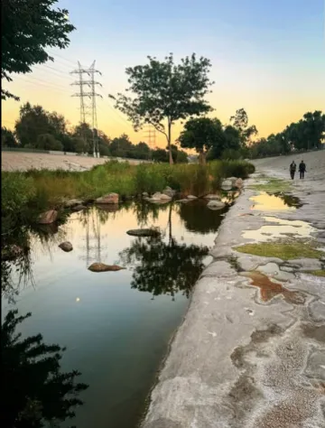
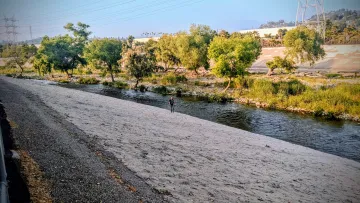
The LA River has always had caretakers but for many who live here, this river that shaped our home is often completely ignored. It’s easy to be so busy in this city that we only see a concrete channel while moving at 80+ mph on the freeway. If this describes you then getting to one of only three soft bottomed sections of the river will change how you think about water here in LA (and it might even change your life).
The Sepulveda Wildlife Preserve
In the San Fernando Valley, where the 101 meets the 405, is a 225 acre preserve with ponds, creeks, and a 2.4 mile soft bottomed stretch of the LA River. I talked about this area in my last blog post but as a refresher you can find over 200 species of birds, see water moving in natural creekbeds, visit “Starfleet Academy” at the Tillman Water Reclamation Plant and accompanying Japanese Gardens, and even go fly fishing. This park is 5 miles from the Metrolink Ventura Line Van Nys stop or get even closer by taking the G Line (Orange) to the Balboa Boulevard Exit.
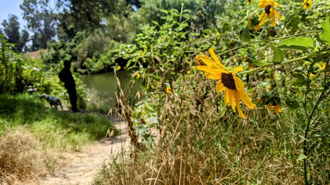
The Glendale Narrows
Grab your bike and head out on the Elysian Valley Bike Path to get great views of this 11 mile stretch of the river that (due to the high water table) was never completely encased in concrete and therefore has more natural appeal. Great for bird watching and fishing.
Long Beach Estuary
The LA River makes its 3 mile transition from channelized river to soft bottomed estuary starting at Willow Street in Long Beach. Just a miles walk from the Willow Station of the A (Blue) Line you can access this prime bird viewing and walk along the bike path until you reach the Pacific Ocean.
Get Involved- @Folar @sepulvedawildlifepreserve @sanfernandoaurdobon @riverparklb @lariverarts @lawaterkeeper @lacorps
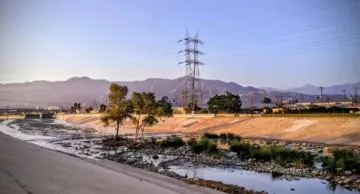
San Gabriel River
Flows 58 miles from San Gabriel Mountains to Seal Beach
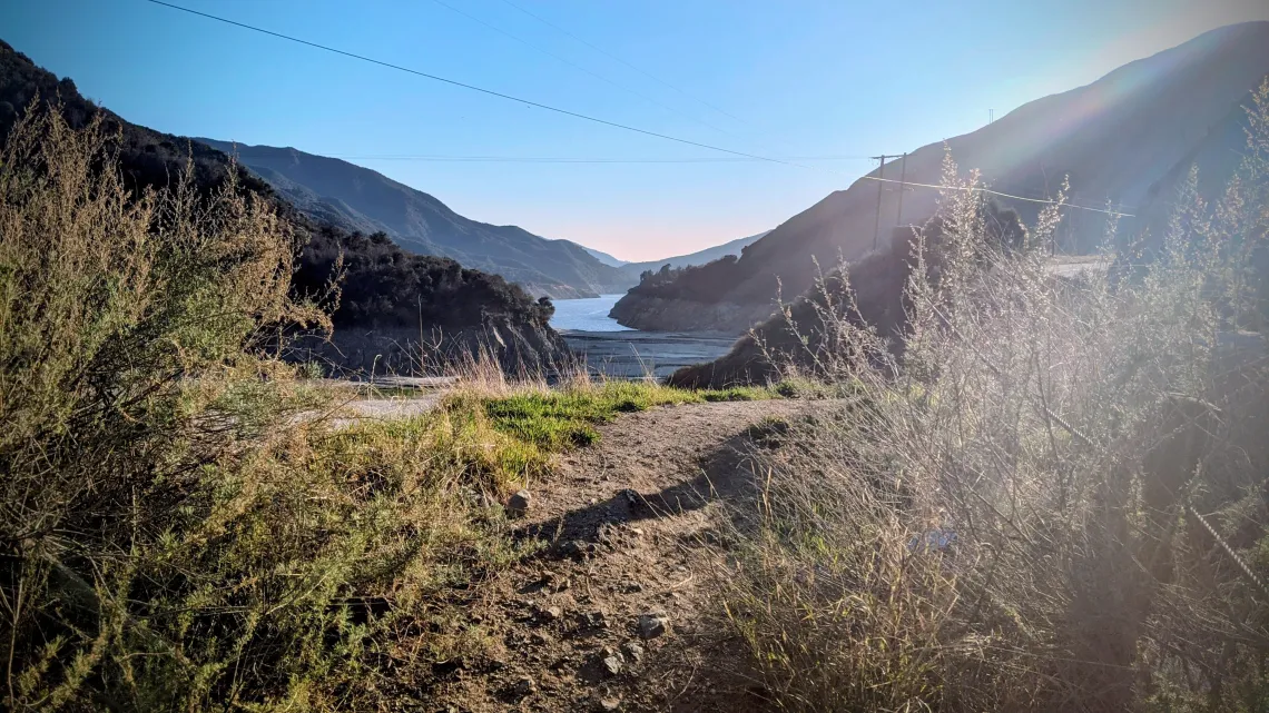
Today the LA River is born into a very urban path right from the start, but the San Gabriel River has it’s origins in much higher ground way up in the San Gabriel Mountains. Two forks, the East coming from Mt. Baldy and the West coming from Redbox Saddle, meet together at the San Gabriel Dam. These upper reaches of the river receive up to 33 inches of rain per year and are often covered in snow above 6,000 ft during winter, most of this water is captured down below through the use of dams and spreading basins that recharge the aquifer in the San Gabriel Valley.
Emerald Necklace
A 17 mile loop of hiking, horse, and bike trails between Peck Road Water Conservation Area, Whittier Narrows Recreation Area, and several other parks in the region. Take the Metro A Line (Blue) to the Duarte/ City of Hope exit to access the San Gabriel River park or the Metro C Line (Green) to the Norwalk exit to get to this 17 mile loop. There are nature centers at several of these parks and many opportunities for guided walks with local non-profit groups.
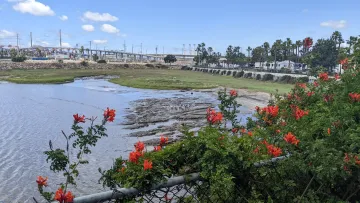
Los Cerritos Wetlands
Today only 500 acres remain of this coastal wetland which once expanded across 2,400 acres. The Los Cerritos Wetland Authority was formed in just 2006 to organize efforts to restore what is left of this delicate habitat damaged by oil extraction, river channelization, and housing development. Go on a guided walk on the first Saturdays of each month or go on a bird walk with El Dorado Audubon on the 2nd or 4th Saturday. The LA Metro A (Blue) Line gets you to Long Beach and there are bike and bus options from there to get to the wetlands. You can also see Pacific Green Sea Turtles here and that makes LA feel pretty wild to me!
Get Involved- @amigosdelosrios @natureforall @lcw_landtrust @sangabrielriverpark @Eastfork @eastforkgoldenpreservation @pasadenaaudubon @eldoradoaudubon @watershedconsercationauthority
Santa Clara River
Flows 83 miles from Acton to Oxnard/ Ventura
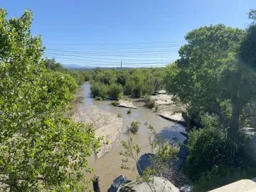
And then there is The Santa Clara River. I finally got to know this river better by attending a TreePeople and CalTrout guided walk this past year. Even though I had lived in Santa Clarita for my first three years I had somehow missed the opportunity to visit this mostly free flowing river. The Santa Clara river is so amazing because it isn’t a concrete channel! Due to later development of the area, The Santa Clara is left to flow in its natural floodplain, meandering through a sandy wash.
Endangered Steelhead Trout still call this river home and it’s tributaries like the Sespe Creek are known as one of the last wild and scenic waters left in Southern California and are where Condors, a endangered bird with an up to 9 foot wingspan, call home as well!
Santa Clara River Trail
8 miles of paved bike path that follow the wash and river in Santa Clarita. The main trail and its feeders are in close proximity to four Metrolink stations, Newhall, Santa Clarita, Via Princessa, and Vista Canyon.
Sespe Creek Confluence
As mentioned the important tributary of the Santa Clara known as Sespe Creek has 34 miles designated as wild and scenic and you can see where this creek meets the river in the town of Fillmore off the 126. There is a Condor Rescue in this area that is closed to the public most days but follow Friends of The California Condors to find out when there are guided walks and restoration days.
McGrath State Beach and Esturary
This park is currently closed to the public due to flooding but it is where the Santa Clara’s estuary meets the ocean so I am still including it in this article to raise awareness about the area in hopes that it could be opened in the future.
Get Involved- @friends_of_santa_clara_river @sespewild @caltrout @southernsteelheadcoalition @cleanwatershed @friendsofcondors
These are the three main rivers in LA County but there are still more to explore in our region! The Rio Hondo, Santa Ana River, Ventura River, Santa Ynez River, and more are all out there and offer chances to learn about and connect to the water, plants, and animals of Southern California. Up next I’ll be sharing about hyper local creeks where you can spend time with water even closer to home here in LA.