What's a Few Hundred Feet?
Why five Americans spent more than a month trekking through a jungle to summit an unclimbed peak in Myanmar

Aerial view of the Putao Valley, northern Myanmar
Photo by Eric Daft/Fisher Creative

A Lisu family poses before a dance performance.
Photo by Eric Daft/Fisher Creative

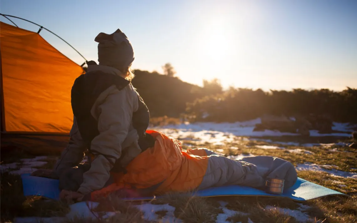
Sunset stroll near the Gamlang Razi base camp in Myanmar.
Photo by Mark Fisher/Fisher Creative

Expedition member Eric Daft cools off the natural way.
Photo by Mark Fisher/Fisher Creative

A Rawang tribesman prepares lunch.
Photo by Mark Fisher/Fisher Creative

A porter carries part of the expedition's load between villages in Hkakabo Razi National Park.
Photo by Mark Fisher/Fisher Creative

Children in Ta Haung Dam, the last village before the peaks.
Photo by Eric Daft/Fisher Creative

The village of Dazundham in Hkakabo Razi National Park.
Photo by Eric Daft/Fisher Creative

Molly Loomis makes her way across a narrow sapling through the thick jungle en route to base camp.
Photo by Mark Fisher/Fisher Creative

Chris Nance takes in the view during a scouting mission en route to the team's highest basecamp.
Photo by Mark Fisher/Fisher Creative

Molly Loomis heads up into the storm on the way to the summit of Gamlang Razi.
Photo by Eric Daft/Fisher Creative

Pyae Phyo Aung holds Myanmar's flag atop Gamlang.
Photo by Mark Fisher/Fisher Creative

When the skies clear, Andy Tyson finally gets a look at the route the team has followed to Gamlang Razi's summit.
Photo by Mark Fisher/Fisher Creative

Andy Tyson crosses a glacial river on the team's way back from the Gamlang Razi advanced basecamp.
Photo by Mark Fisher/Fisher Creative

Aung Cho, a Myanmar Tibetan.
Photo by Eric Daft/Fisher Creative

Eric Daft crosses one of many bamboo bridges lashed together by villagers in Hkakabo Razi National Park.
Photo by Mark Fisher/Fisher Creative
I lie sweating in my silk sleeping sack, fighting the urge to itch. Sand fly, mosquito, and leech bites cover my body in tight braille dots. I am hotter than I've ever been in my life, stuffed with 17 men in a bamboo hut that feels like a kiln.
And this is only the first day of our expedition to summit Gamlang Razi. We still have 44 days, 300 miles, and 80,000 feet of climbing ahead of us. I lock the pillow over my head to dampen the sounds of a generator, snoring, and roosters, wondering whether traveling through remote tribal villages and dense forest to summit an unclimbed peak will be worth all of 100 feet.
Hkakabo Razi, located in an eastern splinter of the Himalayas straddling the Myanmar-Chinese border, has long been regarded as Myanmar's (and Southeast Asia's) highest mountain--and is thus its most famous. Schoolkids chant songs about Hkakabo, and the Khampa Tibetans who inhabit the area consider it sacred. Even the surrounding national park bears the mountain's name. But new mapping data based on the latest satellite and radar technology that was dug up by our expedition leader, Andy Tyson, indicates that just five miles away, another mountain, Gamlang Razi, might actually be several hundred feet higher. Intrigued that such geographical uncertainty still exists, Andy, Chris Nance, Mark Fisher, Eric Daft, and I--whose friendship was cemented while climbing in places like the Northern Rockies, Alaska, and Antarctica--have arrived in Myanmar armed with specialized GPS equipment to see for ourselves.
Hidden behind the curtain of a brutal military regime since 1962, Myanmar (also known as Burma) has been all but cut off from the outside world. It has been nearly 20 years since Japan's Takashi Ozaki, the first and only climber to attempt technical mountaineering in Myanmar, made his ascent of Hkakabo, pegged at 19,294 feet high in ground-based triangulation surveys conducted by the Indian army in 1925.
Andy, who'd rather surf Google Earth, online topographical maps, and satellite images than watch the latest blockbuster, found a discrepancy between Hkakabo's alleged 19,294 feet (a height popularized by noted naturalist Frank Kingdon Ward and later Ozaki, who relied on Ward's writings) and American, Chinese, and Russian topographical maps, as well as recent satellite images that place Hkakabo at elevations ranging from 18,671 to 18,963 feet. Prompted during the visits Andy and I made to their basement office, Harvard University Library's Map Collection staff concluded that Hkakabo could be 18,891 feet high, while Gamlang could be 18,989, making the latter Myanmar's highest peak.
But it's never just about climbing--or measuring--a mountain. Our reasons for coming are as varied as the terrain. For me, it's a return to the mountains after two years of being sidelined with a father fighting cancer and my own knee and spinal cord injuries and subsequent surgeries. For others, it's the last big trip before the obligations of new families take over. To get to the summit, we have to walk hundreds of miles through Hkakabo Razi National Park and cross five tribal areas and a handful of ecological zones, just as early Himalayan expeditions did, aiming for the headwaters of the Irrawaddy River and the flanks of Gamlang. Back home in Idaho, we anticipated that the trek in--with barking deer, rare orchids, and pygmy hunters with poison-tipped arrows--would be as challenging as the climb.
Two decades earlier, Ozaki teamed with Namar Jainsen, a Myanmar Tibetan he'd met in Ta Haung Dam, the last village en route to the two peaks. While a Tibetan's legendary strength at altitude is appealing, our team has opted to include Win Ko Ko and Pyae Phyo Aung, relatively inexperienced climbers from the nascent Technical Climbing Club of Myanmar. The two are part of a posse of young Myanmar eager to climb without hewing to the old-school traditions of the government-controlled Hiking and Mountaineering Federation, whose trips are modeled after slow-moving, high-impact military expeditions, burdened with hierarchical structure and a resistance to new ideas.
As former mountain guides and outdoor educators, we're eager to share our experience. Andy even led a free 10-day mountaineering training course with the Technical Climbing Club earlier in the year. In a country with such a traumatic and tumultuous history--where interactions with the outside world have been severely limited until recently, dissenting citizens can simply "disappear," and multiple civil wars rage between minority tribes and the military--the fact that the climbing club even exists humbles us.
"Ahhhhhh!" yells Win Ko Ko, dropping like a coconut from a bamboo suspension bridge into the cool jade water of the Nantee River. With a week of walking behind us, midday swim breaks, where the guys strip to their Jockeys and I drape myself in a cotton lungi, have become an integral part of our routine. Although we are carrying nothing more than trekking packs (porters schlep our gear and provisions), we still move slowly. We've planned to arrive at Gamlang just in time for a short window of good weather, but as a result, we're caught in one of Myanmar's hottest, wettest times of year. The river's cool respite is key to carrying on--along with umbrellas and hydration tablets.
When boys from a nearby village show up, we coax them into jumping off the rickety bridge too. We teach them how to high-five and fist-bump with varying degrees of success. Our Myanmar liaison, Thet Tun, tells us that most of them have never seen a white person. Although the Rawang, Lisu, Kachin, and Taron tribes we meet were converted to Christianity by an American missionary in the 1920s, very few Westerners or even other Myanmar have been here since. There are none of the "hallos," waves, or smiles that most kids in the underdeveloped world unleash to greet foreigners. Instead they usually stare, or simply run away. Our expedition hopes to change Myanmar's mountaineering history and share modern climbing techniques, but I didn't anticipate the potential for significant cultural impact. I struggle under the weight of something so delicate.
Thet Tun says that not much has changed since he first came here with Ozaki's 1996 expedition--other than there being a few more bamboo huts in one village, a few less in another. But at our departure point, an outpost called Putao, Hkakabo Razi National Park's manager tells me that his hopes for the park's future include a road running from Putao some 150 miles to Ta Haung Dam. I can't imagine the effort of building a road that would traverse the park's countless ravines, which resemble an accordion, or one that could survive the constant onslaught of rain and landslides.
As the Rawang greeting "Pamara" and the taste of ngapi (fish paste) become more familiar, so does the jungle. Jungles demand different practices than mountains. It's not just about keeping the fire going at night despite the heat to ward off insects, the mandatory midday foot-drying sessions, or taking advantage of every waterfall--it's also about adjusting my gaze. Most of the time, I can see only a few feet ahead, and there are no distant land markers to egg me on. Instead I'm forced to concentrate on my immediate surroundings, fixating on butterflies, logging the countless variations in the vegetation's green hues, and trying to guess where the buzz saw of the jungle's enormous cicadas will be loudest.
The days are punctuated by subtle changes: the faces of our shy but generous village hosts, the first pine tree we see high on a ridge, the fading of cicadas as we start gaining elevation. The bridges become narrower and the rivers more choked with rapids, whitewashing the brilliant water. Swarms of bejeweled butterflies are replaced by towering wildflowers. Ten days into our trek, just outside Ta Haung Dam, I pull out my sleeping bag for the first time. From there, we spend four days winding through a Hobbit-land of tight gorges, bamboo groves, and thick rhododendron forests on machete-hacked game trails to reach base camp--a maze of gnarled trees, dripping with moss at 11,500 feet, about 8,500 feet (we think) below Gamlang's summit.
Water is a constant. Whether it's rain falling, profuse sweating, swimming in rivers, or soaked feet ever on the verge of trench foot, we're nearly always wet. But when we reach a bench 4,500 feet above base camp, where we'd planned on setting a high camp for scouting a ragged southern ridgeline to Gamlang's summit, there's no water to be found despite a thorough recon in all directions. That, along with terrible rock quality, forces us to circumambulate the mountain to what we hope will be a feasible glaciated route on its west side.
Then, more water: It pours for days--a bone-chilling drip right above the freezing line. We ferry loads over two 16,500-foot passes and then up again to 15,800 feet, where we install ourselves in a high camp tucked in a moraine. We've been on foot for nearly three and a half weeks, and we still haven't seen our peak. I can't help wondering whether Gamlang, perhaps even Myanmar, is ready for mountaineers.
On summit day we wake to raindrops tapping on our tents, but we stick to our plan because a forecast piped in over the satellite phone predicts that the weather will clear. We hike through the moraine to the toe of a glacier. Out comes the climbing gear, and we scatter upward searching for a path through the labyrinth. It took Ozaki two attempts to summit Hkakabo Razi; his first was thwarted by a crevasse so wide and deep he needed a ladder to cross it. We could face the same predicament at any moment.
"It goes!" calls Andy, indicating he's found a way through the maze. My shoulders relax, and I focus on uncoiling a rope. Each step, each moment on this mountainside makes me fear I've received too much. But like a greedy child, I don't want to stop.
We're high enough now that the rain has turned to snow. But at this latitude, we've got 12 hours of daylight. We rope up and keep moving.
When we're less than an hour up the icefall, it becomes evident that despite the coaching and feedback we've given Win Ko Ko throughout the trip on efficiency in transitions, speed, and footwork, he's not ready for the ascent. It's a tearful moment. Win Ko Ko is climbing for his country, for the sacrifices his family has made for him, and for his young son. But he hasn't been mountaineering long enough to understand the necessity of redefining defeat. It happens all the time in climbing: The summit can't be the only measure of success. Yet the sport is still so young in Myanmar that no one we've met seems to recognize this fact. Again I wonder if we've come to Myanmar too soon.
At 17,000 feet my legs turn leaden and the ratio between my steps and breaths shifts. I've been fighting two infections, and my body is tired. Specks of color seem to dance against the snow, so I shift my gaze to the shaft of my ax to combat the effects of whiteout. With no landmark to fixate on, it's like hiking in the jungle. According to the map and the satellite images we've spent hours poring over, there is no steep avalanche terrain or rockfall zone overhead. But even so, we push ourselves to keep moving, following the waypoints plugged into our handheld GPS. I keep my head down, count steps, and debate whether it's a good idea to know how far we still have to go. I focus on the sound of my breath and the snow's changing resistance and marvel at how the route continues to unfold at a graceful, moderate pitch. I think of the past two years spent sitting in a hospital and pushing through physical therapy. I realize that I know, perhaps better than anything, how to just keep going.
We hit 18,000 feet, but veer too far to the left and get "cliffed out" by a series of clean granite sentinels. This is exactly the quality of rock we'd hoped for on the southern ridgeline--an important detail that can't be determined using satellite images or the Internet. We backtrack, and Chris Nance, now in the lead, takes a few steps forward and stops. "I can't see anything, guys," he says. We are wrapped in white. Lower on the mountain, natural features corralled us in the correct direction. But up here there is nothing to guide us; we are at a critical point in the route where we must find the right ridgeline. Several minutes pass before the clouds lighten enough to give us a glimpse of the faint electric blue of seracs frosting the ridge we've been seeking. The snow is sugary and unconsolidated, the going is tough. But my steps feel lighter.
Six hundred vertical feet and a quarter mile below the summit, the clouds lift again, and we can pick out the white-on-white contours of Gamlang's snowy cap in the distance. I don't want to celebrate until we're standing on top with nowhere higher to go, but I'm flooded with amazement. On a trip with so many potential pitfalls and challenges on every physical, logistical, cultural, and emotional tier, the pieces have come together for six of us to summit. It feels miraculous.
We shuffle along the final ridgeline a cheval. I belay Pyae Phyo Aung onto the summit pedestal. He screams Win Ko Ko's name into the wind, hyperventilating, his face streaming with tears. After checking our GPS data, we descend in the golden glow of afternoon sunlight. We have trekked nearly 150 miles for a single day of technical climbing. Crazy? Maybe. Worth it? Absolutely.
Back in Ta Haung Dam, the villagers gather, dressed in chubas--traditional wrap dresses--and brightly colored aprons for our last night there. Whiskey flows from silver, Aladdin-esque kettles, Tibetan music wails through an old boom box, and the villagers dance in a tight circle against towering corn rows. I shake hands with a Taron pygmy before being pulled into the melee and taught how to dance.
Five days later, we return to the village of Pang Nan Dim, the official boundary of the national park. The wizened basket maker we stayed with on our way in is welcoming me back when I see a black speck in the sky. It's a helicopter, and it can only be for us. A bolt of regret hits. I will never look into this man's twinkling brown eyes again. The disparity between our lives and resources is unfathomable. He is tougher than any of us climbers will ever be. But my tired body and the calls to get moving turn me toward the landing pad.
Upon our return to Putao, we learn that the long-running civil war between Myanmar's military and the Kachin Independence Army in the country's north had spread into the area we hiked through early in the trip. We're told by our Myanmar support staff that a soldier we'd met was decapitated by the rebels--another tragedy in a decades-long civil war. Our tired knees and backs and worries of jungle-induced infections aren't the only reasons a lift out was perhaps in our best interest.
We get to Myanmar's largest city, Yangon, and Andy hears from Juniper Systems, which has made adjustments to the 1,200 GPS points we took atop Gamlang, correlating satellite and barometric information specific to our half hour on the summit. The data, accurate to two meters, has been crosschecked by a Canadian expert. The result: Gamlang is 19,258 feet tall, between 295 and 587 feet higher than Hkakabo.
In theory, the debate over which mountain is higher should be over. Nonetheless, calls begin circulating among local climbers for a team to summit Hkakabo again to settle the question. After all, who'd want to tell schoolkids they have to learn a new song? Even members of our support crew admit they don't believe that Gamlang is higher, but they can't explain why. Before leaving the country, we receive a letter from Myanmar's president, congratulating us on the ascent of his country's second-highest peak. We're OK with that.