A Word from the Chair
As August begins San Antonio’s elected officials return to official business. COSA will be working throughout the month on next year’s budget. COSA will also consider and hopefully approve the SA Tomorrow plans (Comprehensive Plan, Sustainability Plan and Transportation Plan). Unfortunately the delay from June of this approval process, instituted at the behest of District 9 Councilman Krier, means these plans will not officially be guiding the budget process this year. Alamo SC strongly supports these plans as decent first steps to bringing our city’s unmanageable sprawl under some sort of future planning process that may hopefully protect more of our air, land and water resources, among other things. All members are urged to inform themselves about these plans, and COSA residents are urged to tell their District Council person to support these plans.
SAWS
Alamo SC is working on a number of events for August on the continued Vista Ridge saga of deception. We hope to have our own viable alternative Water Management Plan to contrast with the still suppressed SAWS plan. We hope to contrast our WMP with the SAWS assumptions embedded also in the state wide Region L water planning process, which assumes no improvements in water efficiency over the next 50 years. We will continue to call into question the shady financial dealings involved in Vista Ridge. We will continue to hold Councilman Nirenberg accountable to his previous commitment that VR must be friendly to and accepted by our neighbors in Central Texas transferring their water to us, that the finances must be transparent, and that VR must be the best, most cost effective available source of water for our region’s future expected growth. We believe VR fails on all counts.
Air Quality
We hope to have representation approved for membership on AIR Technical Committee, and AIR Advisory Committee of AACOG. This will help in our efforts to participate in processes to meet ozone standards and improve our air quality. We are pleased COSA passed the anti-idling ordinance for large trucks, which is a good first step toward improved air quality.
Political Committee
Alamo Group Political Committee is reconstituted and beginning its important activities of working for our environmental concerns through the electoral process this fall and next spring.
National Parks
The United States National Park Service, an agency of the Department of Interior, was founded one hundred years ago in August 1916. Several parks were already in existence (National Capitol, Yosemite, Yellowstone, Gettysburg Battlefield National Military Parks) when they were brought together under one agency. There are now 412 units in the system, from vast Arctic Wilderness areas like Wrangell-St. Elias (13.2 million acres) to our own San Antonio Missions. There were over 300 million visitors to our NPS system in 2015, bringing revenue into many rural and urban areas. We want to celebrate this important milestone and the vision that has given us today so many wonderful places preserved for us to enjoy. The NPS today, however, is seriously underfunded and facing frequent efforts to privatize or return to state control parts of these federal lands preserved for all of us. If these lands are to remain preserved for our great grandchildren to enjoy 100 years from now, they will have to get strong vocal support from all of us. I would like to have a fund raiser in support of the NPS this fall. Planning is in progress and ideas from all are welcome.
by Terry Burns, M.D., Alamo Group Chair
National Parks and Monuments in the Four Corners
Kevin Hartley will talk about his visits to some of the less well known but quite spectacular national parks and monuments in the four corners region (Arizona, New Mexico, Utah, Colorado), and places to see and camp at on the way there and back. There will be a bunch of his favorite pictures from these places and a few overview maps. Some of these places have been covered in articles in our newsletter; have a look at the current and back issues for the previous year.
Tuesday, August 16th
6:30 p.m.
William R. Sinkin Eco Centro, 1802 North Main Avenue
Map
This event is free and open to the public.
Subdivided: Isolation and Community in America
This film shows life in contemporary suburbia, particularly how to maintain a sense of community in uninspiring design. Andrés Duany, a well known architect and urban planner, is one of the featured speakers.
Thursday, August 25th
6:30 p.m.
Lions Field Adult Center, 2809 Broadway @ Mulberry
Map
Visit the Subdivided website for more about this film, the modern subdivision, and sprawl. In addition, Andrés Duany's firm has an interesting webpage on how to repair sprawl. This event is free and open to the public.
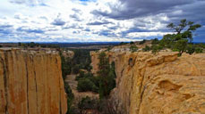
Seen this one? Capitol Reef National Park
Capitol Reef is #6 in a Backpacker.com article, 10 Great National Parks You’ve Never Heard Of. It is located in south central Utah. If you happened to drive through on Utah Hwy 24 from Zion to Bryce Canyon or Arches, you might wonder, as I did, hmm, what's here? Got some good hikes? Scenic overlooks? Campground? Historic stuff? These are all here, but if you venture off the paved roads and main trails the experience is much more expansive. As is true of most national parks. Torrey is the closest town, just west on Utah Hwy 24.
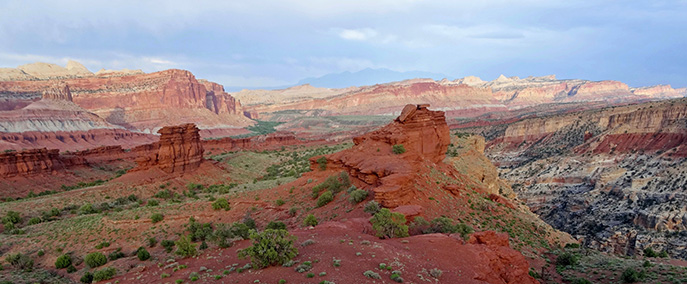
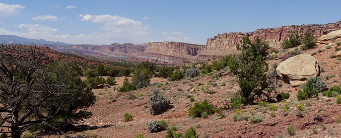
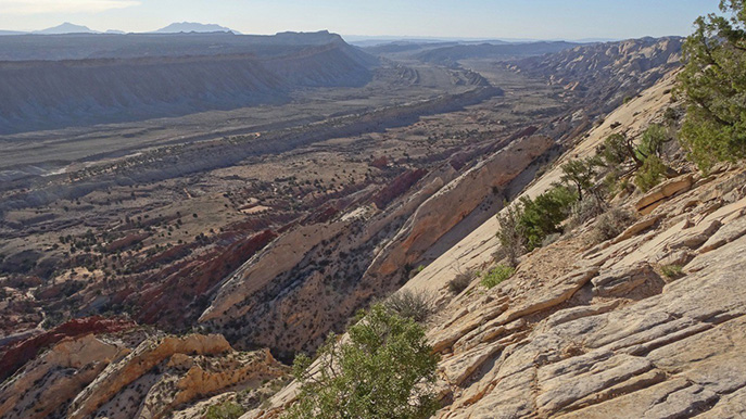
The dominant feature of Capitol Reef is the Waterpocket Fold. This 100-mile long north/south trending monocline formed during the Laramide Orogeny, the same mountain-building period that resulted in most of the mountains of the central west, including the Rockies. Here are a few of my favorite pictures along the Waterpocket Fold and another area just to the north, Cathedral Valley.
There are the trails with great views, some scenic drives accessible to ordinary cars, and a bunch of dirt roads including some for which high clearance or 4wd drive vehicles are necessary. Some of the latter become impassible when wet; you must check at the visitor center. The good campground is first-come-first-serve.
The roads
Here's the NPS web page about the roads. Scenic Drive has great views along the west side of Waterpocket Fold and some nice trails. Usually fine for sedans.
Notom-Bullfrog Rd runs south along the east side of Waterpocket Fold, from Utah Hwy 24 just east of the national park, to Bullfrog marina at Lake Powell. Mostly dirt, usually fine, but best check on the conditions. Here's a web page on this road with a better photo of the east side of Waterpocket Fold than mine above.
34 mi south on Notom-Bullfrog you can turn west on Burr Trail, which immediately climbs over the Waterpocket Fold via a bunch of steep switchbacks. Here's a good guide to Burr Trail on Glen Canyon National Recreation Area's website, with a map. From the top of the Fold it is another 20 mi west to the city of Boulder on Utah Hwy 12 (this highway worthy of another serious visit by itself). From Boulder you can drive north and east back to Torrey and the national park.
The Burr Trail switchbacks: no RVs, trailers not advised, check on the conditions. People concerned about their vehicle might consider separate days; driving Notom-Bullfrog from the north to the switchbacks, have a look at the conditions, and maybe separately drive Burr Trail from Boulder to the switchbacks from the west. Scenery always looks different from the other direction anyway.
There is a 60 mi loop through Cathedral Valley in the north end of the national park. Both ends are at Utah Hwy 24 just east of the park. The west side of the loop (Hartnet Rd) is high clearance required, and spare wheel advised, and there is a fording of the Fremont River just north of Utah 24. The east side (Cathedral Rd) is much smoother and mostly level though impassable when wet. My 4th photo looks down upon the west end of Cathedral Rd from the northern high point of Hartnet Rd. You can reasonably get into the amazing scenery of Cathedral Valley from the east end and not hazard the west side at all. Though there is a lot of great scenery on the west side, of course!
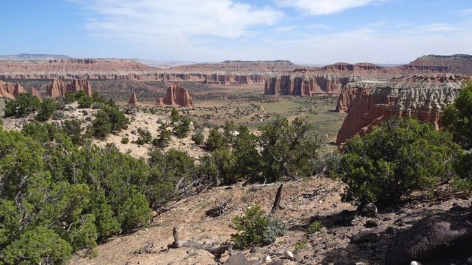
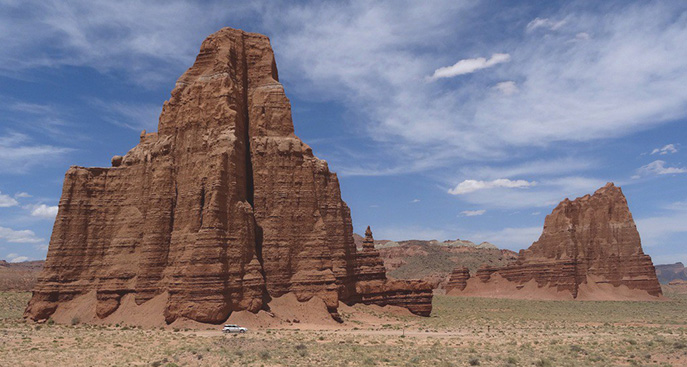
My 5th photo shows the Temples of the Moon and Sun, which are about halfway north along Cathedral Rd from Hwy 24.
For additional info
An excellent guidebook is Capitol Reef National Park by Rick Stinchfield, Westcliffe Publishers. Here's the NPS website with maps, trail and road guides and photos. And a recent Salt Lake Tribune article, Seven Best Hikes in Capitol Reef National Park. Summitpost.org has a big article with lots of photos on Cathedral Valley. Here's an article at Recreation.gov.
Also mentioned in the Backpacker.com article was #7, Guadalupe Mountains, about which there were article in this newsletter February 2016. #8 was Great Sand Dunes in Colorado; there was an article November 2015.
Be prepared
Traveling very far off the paved roads in places such as this can be very rewarding or a serious challenge. Consider: you have some vehicle failure, there is no cell phone service and towing could be $1000+. Best to carry plenty of extra water, food, and gear to stay warm and dry in case you are stuck on a lightly-traveled dirt road for a day or more. And emergency equipment for your vehicle. And of course: don't depend entirely upon your cell phone mapping app, have compass and map, and if there is a problem, stop and think a bit.
by Kevin Hartley, Newsletter Editor