Comments from the Chair
Wanted: nominees for ExCom election
We are soliciting nominations for 2017 Executive Committee members. We will have elections in December (terms normally run 3 years). Please contact me for further information or to submit your name. New volunteers are strongly encouraged to get involved.
City of San Antonio Bond Program
City of San Antonio passed its 2017 Budget. This budget includes good things like money for parks, safe streets, and implementation of the SA Tomorrow plan. The City will be having hearings in October and November concerning bond proposals for spring, 2017 voting.
Visit the Bond Program webpage for Community Meeting dates and other information. I urge all members to pay special attention to these, for the sake of our environment and our fiscal viability.
Dark Skies ordinance
It appears that, despite City Council failure to support this as part of SA Tomorrow, the Military has enough influence that this will probably be implemented, and be City-wide, not carved up into lots of little pieces around various military installations. This will not only help our wildlife (and our sleep and stargazing), it will also save substantial energy (helping limit our CPS air pollution) as the implementation occurs.
Impervious Cover
As San Antonio has sprawled so have its high allowable levels of impervious cover. This has led to persistent flooding problems and increased contamination of the Edwards Aquifer.
A recent report (Council District 9: Official Report on Flooding and Drainage in this District) documents problems caused by impervious cover and poor developer drainage engineering. This report lends credence to calls for less impervious cover throughout the region and more "slow down, spread out, and soak in” solutions, known also as Low Impact Development (LID). Commentary by the Chair of the report committee (Mr. Krier Cries Wolf) provides an informative critique of District 9 Councilman Joe Krier's handling of these problems.
In spite of the billions of taxpayer dollars spent over the years to fix flooding problems, City Council voted to strip impervious cover limits out of the SA Tomorrow plan. Commercial developers with projects on the aquifer recharge zone will be allowed up to 85% impervious cover where they were previously limited to 15%. This is an unfortunate side effect of annexation that the SA Tomorrow plan would have prevented if not for certain City Council members.
However, this issue remains under active discussion. San Antonio River Authority has described a “paradigm shift” toward LID and better water management (see What’s LID? And why is it so important to SA Tomorrow? below). We will continue to push in that direction.
Climate Change
The COSA budget does not include necessary funding for full development of a needed Climate Action Plan (CAP). However, the City will be doing preliminary work in this direction. We will need to actively support this effort over the next several months. It is hoped that in the spring a funding request for this CAP will be submitted, and that by then there will be widespread community support for this effort to start reducing our fossil fuel emissions.
National Park Service
The National Park Service was founded one hundred years ago. Our very own San Antonio Missions National Historical Park is part of NPS and very much worthy of our celebration and support. I urge you to go to its website, and click on “Get involved” and do something this fall to support our NPS and get out and enjoy those parks.
Monday, September 26th: International Day for the Total Elimination of Nuclear Weapons
The consequences of any further use of nuclear weapons, whether intentional or by mistake, would be horrific. When it comes to our common objective of nuclear disarmament, we must not delay -- we must act now.
Secretary-General Ban-Ki Moon
September 26th was the International Day for the Total Elimination of Nuclear Weapons. Almost 200 organizations issued The Montreal Declaration that states in part:
we are collectively calling for a mobilization of civil society around the world to bring about the elimination of all nuclear weapons, to put an end to the continued mass- production of all high-level nuclear wastes by phasing out all nuclear reactors, and to bring to a halt all uranium mining worldwide.
Sierra Club was not among these organizations, but I find several Sierra Club (SC) position statements about nuclear energy and weapons over the last 50 years. In 1981 SC urged a “halt any further development, testing, and further deployment of nuclear weapons. We urge all nations to develop a long-term program to reduce nuclear weapons stockpiles.”
In 1986 SC said “The dangers posed by the probable releases of tritium used by fusion [sic, should be fission] plants, the problems with decommissioning these plants, and their high costs lead the Sierra Club to believe that the development of fusion [sic, should be fission] reactors to generate electricity should not be pursued at this time. We are not opposed to safe and proper research as long as it is not at the expense of more benign "soft energy path" technology.”
Also, the nuclear power industry continues to push for its own “renaissance”, a major component of which is finding an interim storage site so that companies are able to off-load the tons of radioactive waste that has accumulated at nuclear power plants around the country. West Texas is a prime candidate for this storage, and San Antonio on a major route for rail and road transport of this dangerous waste.
We continue to oppose nuclear mining, near the Grand Canyon and elsewhere such as in South Texas, and transport and “interim storage” of nuclear waste. We continue to support just compensation to the people and communities, especially Native Americans, which have suffered great harm from this industry and our government.
by Terry Burns, M.D., Alamo Group Chair
Texas Land Conservancy - a state-wide land trust

Texas is the second fastest growing state in the nation – what does this mean for our resources, our communities, and our future? At our October General Meeting, Ashley Lovell, Ph.D. will tell how to work with communities to protect healthy ecosystems, get kids outside, and grow responsibly.
Tuesday, October 18th
6:30 p.m.
William R. Sinkin Eco Centro, 1802 North Main Avenue
Map
Dr. Lovell is the Director of Partnerships and Outreach at the Texas Land Conservancy, a state-wide land trust. She joined the TLC staff in September, 2014 with a background in environmental communication, conflict resolution, community outreach, and environmental education. Her outreach experience includes organizing and facilitating workshops for the National Park Service, the US Forest Service, the Oglala Sioux Tribe and a variety of other non-profit and governmental organizations. Dr. Lovell also worked as a naturalist for the Aspen Center for Environmental Studies and as an educator at Colorado State University. She earned her Ph.D. from Colorado State University in Environmental Sociology in 2014.
Speak up to the TCEQ!
The Texas Commission on Environmental Quality (TCEQ) holds hearings once a year to receive comments from the public on what actions the commission should take to protect the Edwards aquifer. Here are details on the San Antonio hearing:
Monday, October 24th
2:00 pm
Al J. Notzon III Board Room, Alamo Area Council of Governments - Tesoro Building
8700 Tesoro Suite 100, San Antonio, 78217
Although that TCEQ has never implemented any of the recommendations previously submitted, it’s important to have a big turnout to speak up at this meeting – precisely because it’s about matters relevant to the recent city Council annexation of areas over the Edwards aquifer recharge zone. It is also highly relevant to the SA Tomorrow planning process. We need to insist upon low-impact development over all the zones of the aquifer. See the website of the Greater Edwards Aquifer Alliance for info on previous years’ recommendations.
Here’s an excerpt from the TCEQ announcement:
Annual hearings are held on the Edwards aquifer protection program and the TCEQ rules, 30 Texas administrative code Chapter 213, which regulate development over the delineated contributing, recharge and transition zones of the Edwards aquifer.
These hearings will be structured for the receipt of oral or written comments by interested persons. Individuals may present oral statements when called upon. There will be no open discussion during the hearings; however, commission staff members will be available to answer questions 30 minutes prior to and 30 minutes after the conclusion of each hearing. Registration will begin 30 minutes prior to each hearing.
by Meredith McGuire, Conservation Committee Co-Chair
Important environmental policies at stake in upcoming election
Please keep the environment in mind as you cast your votes this month or next. I know the environment is not the ONLY issue, but for us it is a critically important issue at this time of mass species extinctions, climate change, budget cuts to our parks and public lands and attempts to privatize these same, budget cuts to the agencies charged with protecting our working people (OSHA) and our environment (EPA etc.).
The Sierra Club has endorsed 30 candidates for the Texas legislature; at least one local candidate has a close race in a swing district. Please go to TurnTexasGreen.org to identify our endorsed candidates and do everything you can to help them. Thanks!
by Darby Riley, Political Committee Chair and Terry Burns, Alamo Group Chair
What’s LID? And why is it so important to SA Tomorrow?
The September general meeting of the Alamo Group featured guest speaker Steve Graham, assistant general manager at the San Antonio River Authority. Mr. Graham is responsible for several missions of particular interest to Sierra Club members: Low Impact Development (LID), water quality of the San Antonio River basin, flood control, and environmental protection.
He spoke about the negative impacts of impervious cover – hard surfaces, such as roofs and concrete, that prevent water from soaking into the soil. Mr. Graham explained how scientific evidence documents that natural ground cover (e.g., with grasses, shrubs, and trees) has greater evapotranspiration (40%) from plants and greater infiltration of rainfall into the shallow (25%) and the deep (25%) areas of soil, but only 10% runoff.
By contrast, in cities with lots of impervious surfaces (75%-100%), rainfall results in only 30% evapotranspiration, and infiltration into the shallow (10%) and deep (5%) levels of soil. Worst of all, 55% of that rainfall becomes runoff – polluted and potentially destructive flows, damaging the natural and built environment.
Mr. Graham further emphasized the importance of science-based decision-making about impervious cover, because too often developers or city planners use conventional building materials and designs, rather than Low Impact Development practices. Because Low Impact Development involves distributed, small-scale management practices (like rain gardens, rainwater harvesting, bioswales, and permeable pavement) – rather than centralized stormwater controls using expensive, large-scale construction -- it is relatively inexpensive and easier to build out over time.
This lecture was VERY timely, because Low-Impact Development practices – especially reducing impermeable surfaces – was one of only two parts of the Sustainability measures of SA Tomorrow that were watered down in the most recent phase of the planning process.
Building with or retrofitting for LID is closely linked with our Water Management proposals for San Antonio. So we showed two short videos at the end of Steve Graham’s talk. They and several other inspiring videos or illustrations are on an Alamo Group webpage under the heading “What can Melbourne (Australia) teach San Antonio about living with drought?”.
- Melbourne Wholesale Markets — large-scale and relatively high-tech - saves 68 million liters (nearly 18 million gallons) per year.
- Total Watermark: City as a Catchment – note: the link to the video is near the bottom of this page. The 6th video on that webpage “Climate Change Adaptation – Melbourne’s story” is very relevant to the City of San Antonio’s report “Climate Vulnerability Assessment, 2016.”
Melbourne embraced integrative new ways of thinking about water in urban design. Conclusions? As we face the uncertainties of climate change-driven weather extremes and the unpredictable courses of future severe droughts, the way forward requires us to think differently about the problems and solutions. As we learned about the approach that S.A.R.A. is using, I couldn’t help but think of how close it is to what Melbourne did.
by Meredith McGuire, Conservation Committee Co-Chair
Maine: hiking Katahdin, and a new national monument!
Katahdin
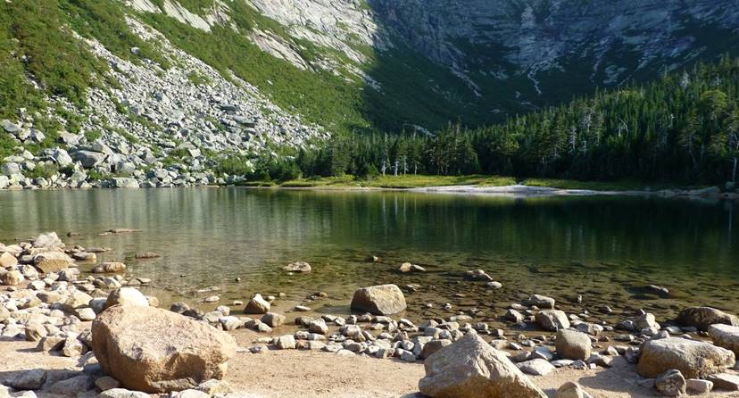
Some of us are familiar with various sections of the Appalachian Trail, though the northern terminus, Baxter Peak on Katahdin, is a bit out of the way for many. Katahdin is in northeastern central Maine, in Baxter State Park.
Henry David Thoreau visited this area from Walden Pond in 1846 and ascended Katahdin, as covered in his memoir Maine Woods. It took him weeks to do it, with much of that time being spent traveling up the west branch of the Penobscot River, which was the only highway in the area then. Today we can drive to the trailheads from Bangor in a few hours and summit with a day hike, though including nights at a campground is less stressful and much more fun.
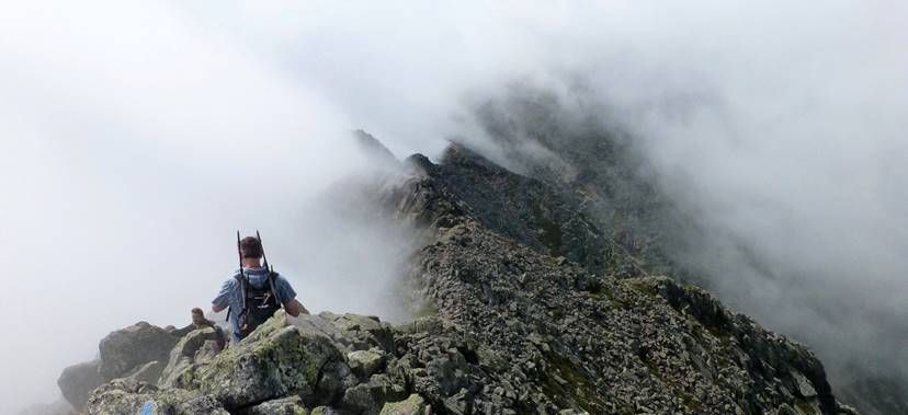
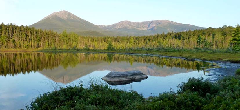
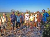
The routes up Katahdin are very popular summers. There are day hike options to Baxter Peak and back though rather strenuous. I did a couple nights at the Chimney Pond campground below Katahdin before and after the loop hike across The Knife Edge and Baxter Peak (see my 1st image). The loop from Chimney Pond is only 5.5 mi; a wonderful memory remains of climbing over and around basalt bits up to small house size, some sections being hand-over-hand though not technical. I started late due to being afraid of route finding difficulty in the fog (wasn't a real problem), then the fog didn't really clear, so missed out on my planned descent across Hamlin Peak, which in retrospect I wish had done anyway. I followed this with a night at Martin Ponds campground (wild blueberries for my granola!), with a good view of Katahdin (3rd image below).
The AT approaches Katahdin from the southwest along the Hunt Trail, which is much friendlier than The Knife Edge. Thoreau apparently hiked up the Abol Trail route, which is just to the south of the Hunt Trail.
Further about Baxter State Park
Here's the park's website, with info on the trails, campgrounds and so on. And the Wikipedia page. Here's a BSP history page at Maine – An Encyclopedia. And another 3rd party informational website. Here's Henry David Thoreau's Ktaadn passage from Maine Woods, extensively annotated.
A new national monument: Katahdin Woods and Waters
On August 24th President Obama designated this new monument, for which the National Park Service acronym is KAWW; here's the official proclamation. KAWW is just east of Baxter State Park, Maine. At 87,500 acres this is much smaller than the national park originally worked towards by many including the donor of the land, Roxanne Quinby, the founder of Burt's Bees.
Here's the official map as it exists today; I imagine a better one will be forthcoming. At the top of KAWW's home page there is the super panoramic photo below, I imagine on the east branch of the Penobscot River, which forms the east boundary of the west and main section of the monument. Also on the website there are some alerts about road construction projects; NPS is hard at work getting ready for the increase in visitors.
The International Appalachian Trail stretches northeast from Katahdin through KAWW into Canada. The IAT website has a big article about KAWW.
Here's the Wikipedia article, and a Backpacker.com article.
Explore Maine!
The Natural Resources Council of Maine has a good website; in particular note the Explore Maine interactive map. There are a zillion great places to check out. In particular I think Cutler Public Reserved Land is quite fantastic, on the Bold Coast. Maybe I can do a future article on some of these places.
Acadia National Park is the first eastern national park and celebrates its 100th anniversary this year. Mostly comprised of Mount Desert Island in southeast Maine around the city of Bar Harbor, it can be very crowded summers. But there are more lightly frequented areas west at Seawall and east on the Scoodic Peninsula. There is great hiking along the coast, around ponds and across mountains, and good bike routes on the historic carriage roads.
by Kevin Hartley, Alamo Group member
Outings: The Call of the Wild
Visit the Alamo Sierra Club Outings page on Meetup for detailed information about all of our upcoming Sierra Club Outings.
Texas Rain Catcher Award
The TWDB’s Texas Rain Catcher Award recognizes excellence in the application of rainwater harvesting systems in Texas, promotes rainwater harvesting technology, and educates the public on this important water-saving practice.
The City of Austin, in collaboration with the Water Environment Research Foundation and Geosyntec Consultants, installed an internet-enabled, real-time controller on the 5,000-gallon rainwater harvesting system at the Twin Oaks Library. The real-time controller was part of a pilot study to demonstrate this technology as an innovative and improved approach for rainwater harvesting management.
The real-time controller detects when the cisterns are less than half full and then automatically reduces the volume of water used for the on-site landscape irrigation system. The controller also integrates weather forecasts and automatically drains its cisterns when the chance of a storm exceeds 60 percent, thereby increasing the storage capacity for collecting stormwater runoff. The drained water is directed to the landscape irrigation system and rain garden. The system at the Twin Oaks Library demonstrates how internet-enabled, real-time control technology is a cost-effective measure for water conservation and stormwater management.
by Meredith McGuire, Conservation Committee Co-Chair

Bring your used batteries to the General Meeting
Don’t throw those small batteries in the trash bin where they will end up in our landfills. Bring them to the monthly general meetings where we will have a container for you to place them in. Thanks to Gay Wright for coordinating this recycling effort.
October Lions Field film cancelled
There will be no Lions Field event in October because the room is being used for early voting. Furthermore, since our “fourth Thursday” events conflict with holidays, they will not be held in November and December.
by Barbara McMillin, Speaker Program Chair