Comments from the Chair
Join us for the Alamo Group's 50th birthday party
2018 is the 50th Anniversary of the founding of our local Alamo Group of the Sierra Club. The National Sierra Club was founded in 1892 in California, named after the Sierra Nevada Mountains of that state, where founders like John Muir liked to hike.
Our Alamo Group has a lot to celebrate in our 50 years, perhaps most notably, our lawsuit that resulted in protection of the Edwards Aquifer, formation of the Edwards Aquifer Authority and of SAWS, and protection of endangered species and spring flows dependent on the EA. The broad coalition fight that resulted in CPS NOT building two new nuclear plants STP 3 and 4 was also a major victory.
The Alamo Group has been and remains actively involved in a wide range of local environmental issues that impact endangered species, air quality, water resources, transit and many other factors affecting our quality of life in this region. Please join us on June 2nd to celebrate 50 years of volunteer effort to improve life in San Antonio and the surrounding region. Details are in the announcement below.
Climate plan details being hashed out now
The City of San Antonio Climate Action & Adaptation Plan is in process. Committees and technical working groups have formed and are beginning detailed work.
Community involvement is vital to this process. Environmentalist involvement is vital to this process. I have serious concerns that traditional powers in our city are already acting to subvert the process. Without strong vocal community involvement, our goals of major reductions in greenhouse gas emissions, improvements in energy efficiency, reductions in energy demand and smart and sustainable mitigation strategies will be watered-down to "feel-good" language.
We must insist on equitable implementation of these plans for dealing with climate change effects. We can't settle for policy goals without teeth, another plan on the shelf, and little more. The Mayor and Council need our back to be able to stand up to status quo supporters if we are going to push this plan forward, and push COSA forward with strong implementation goals.
CPS & SAWS board appointments perpetuate the status quo
We recently witnessed board appointments to SAWS and CPS. Witness is the proper term since we citizens had essentially zero opportunity to weigh in on these appointments.
Nominations and appointments to these bodies follow a “self perpetuating board” model, where the current board selects its new member(s) and City Council approves. These appointments are traditionally honorary appointments to notable members of the community in recognition of their past achievements in their careers. In general, there is no requirement that they know anything about the board or utility to which they are nominated.
Nominations also have a geographic component, so that all parts of the community are “represented”. The CPS nominations generated considerable controversy regarding gender representation. The Alamo Group believes that the nomination process to these utility boards should be revised so that there is wide publication of openings, applications are reviewed with some ability for public input, question and comment, and City Council takes a much more active role in the selection process and final choice of members.
In particular, basic qualifications for these positions should be established and made public, e.g. basic knowledge of the utility industry overseen by the board. At a time of critical growth in our city, rapidly changing technology and impacts of climate change, it is unfair to all of us to have “honorary” board members “learning on the job” to oversee our utilities. We will continue to push CoSA and the utilities to open up this process to public input.
City utilities need new pricing models
Our utilities are major sources of revenue for our CoSA budget. Our utilities also continue to use a financial model that generates more revenue for more sales of electricity or water.
This "fee for service" model is becoming more and more difficult to sustain around the country as infrastructure needs become ever more costly and place ever greater burdens especially on less financially fortunate parts of our community. The "fee for service" model also directly conflicts with environmental goals of conservation and reduced demand for water and electricity.
Alternative pricing models exist and we must get our local utilities, and COSA, to begin the process of changing to a more sustainable, conservation friendly revenue model, that supports utility fiscal viability, and COSA revenue needs, while still promoting efficiency and conservation instead of increased resource use.
Chambers less than enthusiastic about Mayor's transpo plan
The Mayor recently proposed a major new initiative called “Connect SA” to address our transportation needs. Apparently, his proposal was met with silence by the Chambers audience where it was announced.
Our Chambers love the status quo and no progress will be made except with full community backing to overwhelm the powers of the Chambers. Mayor Nirenberg recognizes that inadequate transportation infrastructure is a major drawback to life in SA, especially to attracting more millenials to live here.
His proposals sound very encouraging, especially in recognizing the need for better transit, and better transit funding, as well as the critical importance of managed lanes so buses don’t sit in traffic with all the other vehicles. Likewise the needs for much better (and safer) bicycle and pedestrian travel are highlighted. Alamo SC will be working to support the best aspects of these proposals, which the Mayor hopes to bring to a city vote by next year’s spring elections.
Chapter recognizes work of local Sierrans
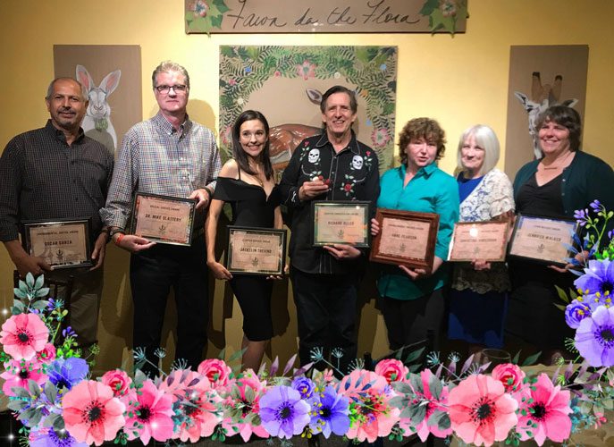
The Alamo Group was proud to receive two major awards at the April 28th Lone Star Chapter Awards banquet. Anne Pearson, Christine Anderson and Rita Neureuther received the Virginia Murray Brewer Award for their long-time fabulous work with our Sierra Club Youth Outdoors program.
Richard Alles received the Chapter Conservation Award for his dedicated efforts to pass, improve and protect our local tree ordinance. The last State legislature was especially difficult, with our local tree protections under full direct attack by the Governor. However, Richard’s leadership and hard work once again largely prevailed in protecting San Antonio from most of the extreme efforts to destroy our trees.
Finally, the Environmental Reporting Award went to our local journalist Brendan Gibbons for his excellent environmental reporting, first at the Express-News and now at the Rivard Report.
As you can see, much is happening in our city, and despite the horrors at the national level with our parks, the EPA, etc. we can all make a positive difference here in SA. We always welcome more volunteers.
by Terry Burns, M.D., Alamo Group Chair
CELEBRATION CANCELLED DUE TO WEATHER, TO BE RESCHEDULED
Celebrate 50 years of the Alamo Group of the Sierra Club!
You are invited to celebrate 50 years of environmental victories, activism, advocacy, outings, meetings and parties of the Alamo Group of the Sierra Club. We will have a gathering of members and friends, past and present, at the home of Olivia Eisenhauer, a longtime member of the Alamo Group.
This will be an opportunity to meet old friends and to make new friends who like to explore, enjoy and protect the planet. Please extend a personal invitation to Alamo Group members and friends that you know who may not be receiving our electronic newsletter.
Saturday, June 2nd
6:00 to 8:00 p.m.
7380 Binz-Engleman Road, Converse
RSVP on Meetup
Map
The celebration will be in a picnic setting around a shady pond on Olivia’s farm in Converse. The Alamo Group will provide a main course and non-alcoholic drinks to be supplemented by potluck items from the attendees.
Those with surnames from A to L can bring vegetable side dishes. Those from M thru Z can bring salads or healthy dessert items. You are invited to bring any special alcoholic and non-alcoholic drinks that suit your fancy.
We also ask attendees to bring reusable plates, cups, glasses and utensils as good environmental stewards. In addition, you may want to bring a chair to sit on.
Directions
Olivia’s farm is located at 7380 Binz-Engleman Road in Converse. One approach is to travel east on IH-10 and after passing its intersection with Loop 410 take Exit 583 for Foster Road. Turn left (north) on N. Foster Rd. Travel 1.3 miles to the second light which is Binz-Engleman. Turn right and travel just short of 1 mile to a right turn onto Olivia’s farm road. The entrance has a purple gate and purple mailbox. It is just past a buried gas line sign. Travel down the gravel road and take the right fork to get to the pond.
RSVPs, etc.
The event will be cancelled for heavy rain due to the potential for road flooding but may not be cancelled for light rain if it can be accommodated on a porch. Any questions and suggestions for speakers or music for the event can be directed to Jerry Morrisey (210) 382-2614. Olivia Eisenhauer can answer questions about the venue at 210-661-2150. Please RSVP on our Meetup page or to Jerry Morrisey.
Improving Stormwater Management in San Antonio
This month, our General Meeting presentation is by Debbie Reid, Technical Director, Greater Edwards Aquifer Alliance (GEAA).
Tuesday, May 15th
6:30 p.m.
William R. Sinkin Eco Centro, 1802 North Main Avenue
Map
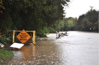
Developing an effective regional Green Stormwater Infrastructure is one of the most important parts of San Antonio’s climate readiness. The City must not wait until the Climate Action and Adaptation planning process is done before it changes the way San Antonio manages stormwater. Because green infrastructure is both a way of adapting to Climate-Change impacts of extreme weather events (flooding, drought, and heat waves) and a way of reducing greenhouse gas emissions (thus effecting Climate Action), it is central to the City’s efforts to be “Climate Ready SA.”
GEAA’s new position paper makes specific recommendations that the City could (and should) follow. Come learn about and give helpful feedback about these recommended practices at our May Sierra Club meeting. Then, be prepared to push for our City Council to approve necessary ordinances and to incorporate adequate funding for these measures into the 2019 City Budget.
San Antonio needs to change how it manages stormwater ASAP -- before the next major flooding episode!
This event is free and open to the public. Socializing begins at 6 p.m. and the program starts at 6:30.
One of the Best Backpacking Routes in the Continental US, in Grand Canyon National Park
Grand Canyon National Park is incredibly vast and varied. Most visit briefly, see a little bit and hopefully realize they have seen just a tiny fraction of the landscape and scope. Backpacking below the South or North Rims is an entirely different story.
Likely less than 1% of visitors here do a backpacking route, and a further small fraction of those venture away from the corridor trails. This is serious business, as people die here each year, though that is usually due to poor preparation and planning or avoidable accidents.
Your enthusiasm may build as the pain memory fades and confidence increases! What about all these other South and North Rim routes? What about all these areas adjacent to the park, such as Vermilion Cliffs and Grand Canyon Parashant national monuments, Kaibab National Forest, and Glen Canyon National Recreation Area? What about a river trip? A lifetime of adventures stretches across the imagination.
Some Background
The Coronado Expedition of 1540 reached the south rim and not trusting the opinions of Indian guides that the river was not accessible, sent some soldiers down: “From the top they could make out some small boulders which seemed to be as high as a man. Those who went down and reached them swore that they were taller than the great tower of Seville."
Routes to the Colorado from the rims in Grand Canyon have been the question for many centuries. The challenge for locals, including Native Americans, was how to survive summers on the rims and then migrate down routes towards the river and survive winters. There are many documented historical routes, nearly all of of which are very tenuous or technical and could not be called trails.
For us tourists there are a few routes down to the Colorado from the rims, of which the corridor trails (Bright Angel, and South and North Kaibab) are the most accessible and heavily used. Also from the south rim there are the Hermit and Bass trails to the west, and Grandview, Hance and several others to the east, all largely unmaintained. The latter can be challenging and risky depending upon the season, and require additional experience and planning.
Bright Angel Trail goes down from the south rim at Grand Canyon Village and is rather busy, particularly near the top, and carries mule traffic, mostly above Indian Garden (the midpoint on Bright Angel). Even if visitors can't do a real trip, it is a revelation to simply walk down the Bright Angel a few miles and begin to get a feel for what you are looking at.
The route
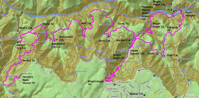
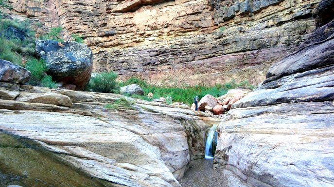
I arrived at the Backcountry Information Center in Grand Canyon Village March 2009. I had the grand idea of hiking rim-to-rim as that seemed the thing to do. I couldn't get a permit per my schedule for the corridor trail campgrounds, the usual bottleneck, but a ranger said there was a better option. This was a route using the Hermit, Tonto, South Kaibab and Bright Angel trails. Indeed this is one of the best easily accessible backpacking routes in the park and surely one of the best in the continental US.
The route on the map below is 40 miles with the max elevation difference being 4000', and is comfortably done in six days. You can leave your car at Hermit's Rest and take the shuttle back to the Bright Angel trailhead to start, or leave it at Backcountry Information Center if going the other way. You can get the gate code for the road to Hermit's Rest if you have a backcountry permit including Hermit Trail.
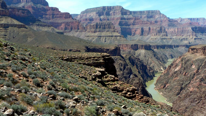
Very mellow experiences en-route include the day hikes from Hermit and Monument Creek campsites down to the river, not to be missed! And the super day hike loop included in the mileage and on the map, to the east, from Indian Garden campground to the river and back via the South Kaibab and Tonto trails, 12 miles. Therefore spend two nights each at Hermit Creek and Indian Garden.
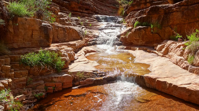
Hermit is lightly used. There have been serious rock falls in recent years near the middle of the trail but these are not difficult to get through if you look around and move carefully. Tonto gets even less traffic, is more or less level and smooth with grand vistas across the Colorado, and you get amazing views of the river itself from various spots (eg the picture above).
I have done this route and more further west, east and north various times with friends and several other Alamo Group outing leaders. Stupendous experiences.
The Tonto continues west to South Bass Trail, that's another 4 days! And, east to Grandview Trail, also 4 days! And further east are yet more routes! And that's just the South Rim!
Visiting
If you want to overnight below the rim you need a backcountry permit. There are also day hike opportunities.
Backcountry permits can be hard to come by during peak periods (March-April and October-November) as summers are very warm on the Tonto Plateau (around 3600') and even more so at the Colorado (2400'). The South Rim is nearly 6000', so snow and ice are common in winter, but down canyon it is nice at that time.
Permits are granted by lottery, with requests needing to be in by the 1st day of the 4th month prior to your desired start date (eg for April, in by December 1st, and you would likely hear whether your request was granted by mid-December). To maximize your chances provide the largest start date window possible and the reverse direction option. Once you have your permit you can reserve a site at Mather campground or a hotel room at Grand Canyon Village.
Here is the maps page. From the backcountry page you can get the info needed for planning including the park's excellent trail guides and an important 5-1/2 minute podcast about smart hiking.
Further Reading
I recommend two books by by Colin Fletcher: The Man Who Walked Through Time and River. In 1963, Fletcher became the first person to hike, in one trip, entirely through Grand Canyon National Park below the rim along the Colorado River. In 1989, he rafted down the Colorado, solo, from its source to the Gulf of California.
Another good resource is The Essential Grand Canyon Reading List by National Geographic, and another book list at grandcanyontreks.org. Finally, see our prior newsletter articles about Grand Canyon (with pictures) in the April and June 2016 editions.
by Kevin Hartley, Alamo Group Outings leader
Change the City
As San Antonio begins to develop a Climate Action and Adaptation Plan, it’s important to look around the world to see what other cities are doing. Extreme Cities: The Peril and Promise of Urban Life in the Age of Climate Change (2017), a new book by Ashley Dawson, provides such a global view. The book focuses on big coastal cities like Miami, New York, New Orleans, and Jakarta, which are destined over the 21st century to receive catastrophic damage from rising sea levels and simultaneous subsidence of coastal land.

Dawson, a New Yorker, explains in detail the response of her city to the devastation of Hurricane Sandy. Occupy Sandy, an outgrowth of the Occupy Wall Street volunteer activism, became the most effective emergency response team. “A week after the storm hit, Occupy Sandy’s Facebook page had 10,000 likes and it had 5,000 followers on Twitter. The initial aid network by this point had a roster of 700 volunteers and was serving 20,000 meals each day across the city.” The organization set up neighborhood hubs across the region and was much quicker and more flexible than established organizations like the Red Cross.
Dawson’s main theme is one similar to that of the Climate Action San Antonio (CASA) coalition, a group of local organizations working for social and environmental justice in reference to climate change. The idea is that part of preparation for the coming floods, droughts, and other extreme weather requires creating a more just social order before the storms hit. Low income people occupy the most vulnerable spaces and suffer the most. So part of a climate action plan is the fight for a more just social order.
“The good city is a city of modest consumption, shared goods and services, alternative technologies, reduced waste and recycling, taxed excess, pooled technologies, public transportation, and shared housing, all defined as environmentally urgent,” concludes Dawson.
Creating the good city is the challenge posed by climate chaos. Dawson points to the Northern Manhattan Climate Action Plan (2015) as an example of community-led planning; and the People’s Agreement of Cochabamba (Bolivia 2010) as an example of global visioning on climate change from the ground up. The dominance of elites and real estate capitalists in the city planning process (a global problem) must end if we are to survive.
by Darby Riley, Political Committee chair
Outings: The Call of the Wild
Visit the Alamo Sierra Club Outings page on Meetup for detailed information about all of our upcoming Sierra Club Outings.
The Alamo Sierran Newsletter
Richard Alles, Editor
Published by The Alamo Group of the Sierra Club, P.O. Box 6443, San Antonio, TX 78209, AlamoSierraClub.org.
The Alamo Group is one of 13 regional groups within the Lone Star Chapter of the Sierra Club.
Keep your email address current!
Send updates to Loyd Cortez, providing your name, address and membership number (if known).
Changed your mailing address?
Have you moved? Let us know by sending your old address, your new address and your member number (look on the upper left corner of your mailing label) to: address.changes@sierraclub.org.
Go online for the latest news and events
 |