Comments from the Chair
Committee members needed to implement CAAP
Committees will be formed and implementation will begin soon. Volunteers are needed to make this Climate Action & Adaptation Plan successful.
Reform still needed at CPS Energy
CPS leadership remains entrenched and resistant to meaningful public involvement. We are developing strategies for 2020 to confront this challenge. Volunteers are needed!
End subsidies for new growth
The Rate Advisory Committee is at work providing SAWS public input on how to restructure (and no doubt raise) water rates. We continue to monitor their activities and provide input to push for more equity, more conservation and rates that require new growth to pay for itself, no longer be massively subsidized by current ratepayers.
Long-range transportation plan includes bike lanes, bus rapid transit
San Antonio transportation improvement proposals, especially those under the heading of “ConnectSA”, will be a major focus of contention and public discussion for the next year. ConnectSA is a joint project of CoSA, Bexar County and VIA. Please review the PDF proposal at the bottom of the home page. There are several important points:
1) I agree with the general points of the first eleven slides.
2) Slide 12 compares Bus Rapid Transit (here called Advanced Rapid Transit ART) to Light Rail Transit LRT. The points are fair but incomplete in that, while LRT may have greater upfront capital costs it has lower long term costs and provides much more density redevelopment stimulation, precisely because the lanes are fixed.
3) Slides 17, and especially 18, show multiple roadway projects, especially by TxDoT. Slide 22 lists “Construct high-priority segments of the [CoSA] major thorough fare plan’; and “Extend roadway network in unincorporated areas of Bexar County from the County arterial plan”. This roadway construction language could be reasonable; however, great concern comes in the details.
We see current motor vehicle priorities prevailing yet again in the recent controversy about bike lanes on lower Broadway. An excellent opinion piece in the 11/26/19 SAEN (Bike lanes belong on Broadway) points out the gross disparity of funding and other resources given to motor traffic over bikes. That article also very helpfully points out the multiyear lane closures along lower Broadway done to accommodate private multi-resident construction projects. Somehow traffic can be asked to put up with those headaches, but not with bike lanes. Totally unfair, and no way to spur greater transportation alternatives.
4) Slide 24 says “Construct new freeway and street lanes strategically in congested areas”. I am very skeptical of any new pavement for vehicles, unless at specific redesigned intersections etc. to improve safety, as more pavement never improves flow.
5) Slides 26-32 address the critical problem of funding sources. Our transit VIA system is grossly underfunded compared to other cities in Texas. ConnectSA seeks to “Redirect existing sales tax within San Antonio when the Edwards Aquifer and Linear Creek Tax expires”; and “Redirect the City’s share of the Advanced Transportation District”.
These measures could add $36M from sales tax and $18M from ATD (slide 29). The Mayor and County Judge Nelson Wolff are strongly pushing the need to shift the 1/8 cent sales tax away from linear parks and EA protection, without providing any guaranteed funding replacement for these programs so far. SA (Alamo) SC is as yet unconvinced by the arguments that other funds will be found for linear creek parks and EA protection, or even worse, that these projects are “complete” and no longer needed.
6) Slide 28 indicates $1.3B in unfunded project needs for only the next six years, which the sale tax change would not begin to address. Slide 30 points out the potential availability of General Obligation Bonds. This is a better way that $1.3B could be raised, in a low interest environment, and the slide shows Bexar County has not issued a bond proposal (for University Health) since 2008.
Slide 31 also suggests we “Utilize public-private partnerships, wherever possible and appropriate”. We have seen with the Vista Ridge Project the dangers of poorly structured P3 projects. Citizens had no opportunity to provide consent to the $1.4B VR, and the costs of the bankruptcy of its partner Abengoa are hidden from public view.
Hydrologic and many other data used in development of this project are also hidden from public scrutiny, as are almost all of the financial data. We oppose P3 projects that take private money to make private profit under public obligation, using public easement and other leverage, without public transparency.
7) Slide 32 lists two other important possible revenue sources: “Land use policies and fees”; and “Gas tax”. The gas tax has not been increased since 1991. Gas prices are about where they were in 1991, while incomes, construction and other costs have doubled and more. A gas tax increase however is unlikely at state or federal level without major political change, green new deal implementation etc.
At the local level, however, COSA and the County should find ways to change land use policies and fees to aggressively collect revenues that reflect the full real costs of our decades of sprawl development. It is critical for our climate, our air quality and our mobility to turn this path around toward reduced vehicle miles travelled, especially by single occupancy vehicles.
We need volunteers interested in leading our efforts to improve our mobility in SA.
Encourage HEB to reduce plastics
I again urge readers to complain to HEB store managers about excess plastic use throughout HEB. It is time HEB start acting like the good corporate citizen they claim to be.
by Terry Burns, M.D., Alamo Group ChairIndependence Pass, Colorado

Looking southwest across the Continental Divide from CO hwy 82 just south of Independence Pass. Early morning. The divide runs along the sunlit ridge and the pass is to the right of the rightmost sunlit area, barely out of the picture. Mountain Boy summit, 13,198', is just left of center.
The Continental Divide is also called the Great Divide. The latter might be more appropriate as there are a number of continental divides in North America, as mentioned in a Wikipedia article, which was used as the basis for an article in the October 2015 issue of this newsletter (PDF). There is a map of the divides in both articles. The Great Divide crosses Independence Pass, 20 miles southeast of Aspen.
In July 2013, the day after taking the picture of the Maroon Bells used in the May 2019 issue, I drove over Independence Pass and noticed a trail running south along the divide. I thought it would be nice to someday hike that and see how far I might go, and took the picture above. I did do that hike in August 2015, 5.4 miles out-and-back, taking the pictures below. Recently I found a hiking web page on the route and realized I had gotten to an unnamed summit 13,050' though not to Mountain Boy.
The author of the web page above has done another about the route north from the pass along the divide to Twining Peak, 13,711'. I've mapped this as 5 miles out-and-back.
Using on-line maps we can follow watercourses east of Independence Pass to the Arkansas River, which joins the Mississippi south of Memphis. I was thinking these waters might go to the Rio Grande, the headwaters of which are not far south, but no the Sangre de Christo Mountains are in the way. Waters west of the pass run to Roaring Fork River which joins the Colorado at Glenwood Springs.
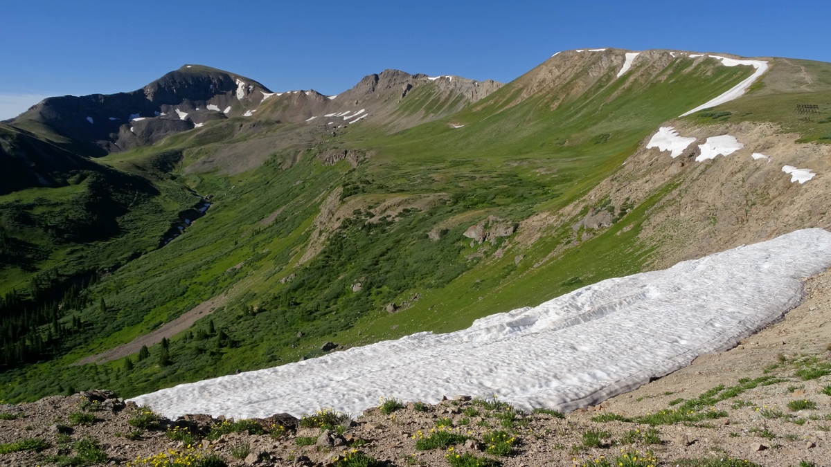
The same ridge as in the first picture, taken from just south of the Independence Pass parking area, looking southwest. The divide follows the ridge across unnamed summits 12,800' right, 13,050' center and Mountain Boy, left.
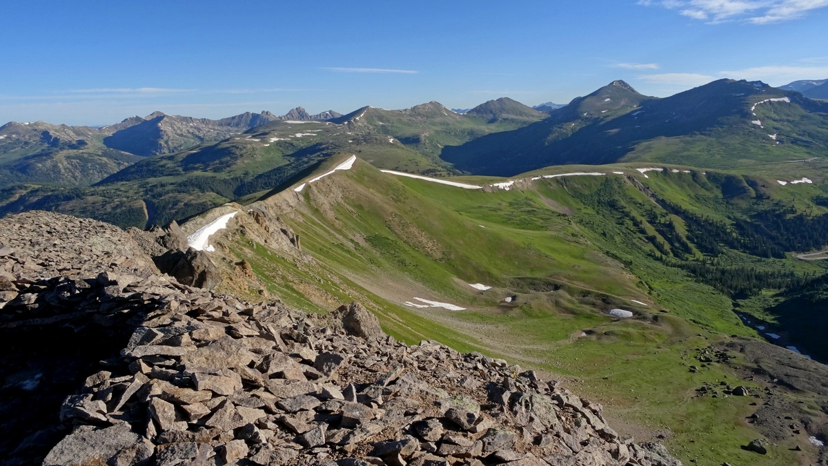
Looking northeast from summit 13,050'. Independence Pass is at the right edge of this picture just above a small snowbank. This is in Collegiate Peaks Wilderness, San Isabel National Forest.
by Kevin Hartley, Alamo Group Outings leader
Outings: The Call of the Wild
Visit the Alamo Sierra Club Outings page on Meetup for detailed information about all of our upcoming Sierra Club Outings.
The Alamo Sierran Newsletter
Richard Alles, Editor
Published by The Alamo Group of the Sierra Club, P.O. Box 6443, San Antonio, TX 78209, AlamoSierraClub.org.
The Alamo Group is one of 13 regional groups within the Lone Star Chapter of the Sierra Club.
Changed your mailing address?
Have you moved? Let us know by sending your old address, your new address and your member number (look on the upper left corner of your mailing label) to: address.changes@sierraclub.org.
Go online for the latest news and events
 |