CPS Energy: No Rate Hikes! No Disconnections!
On May 24th, Alamo Group members and other activists visited CPS Energy's new $multi-million headquarters and spoke at the Board of Trustees meeting. They had two demands: continue the moratorium on disconnections and stop the rate hikes.
At issue are CPS rates that force residential ratepayers to subsidize the city's biggest industrial polluters. For more about the rally and CPS rate hikes, read CPS Energy CEO Gold-Williams: Rate increase – ‘an inevitability’ – could come this fall in the San Antonio Report.
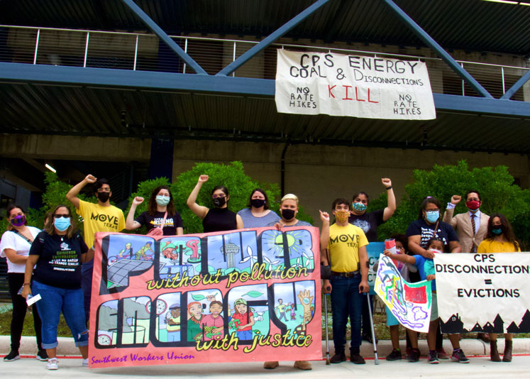
Attorney Darby Riley, author of a City charter amendment to reform CPS, spoke about the Alamo Group's appeal of a court ruling quashing our charter amendment petition. You can watch his remarks at 5:15 in this video of the rally.
Another video highlight (at 2:20) you won't want to miss is kids bashing a Spruce Coal Plant piñata.
by Richard Alles, Newsletter editorSAWS Planning Sewage Pipeline Through Aquifer Protection Land
San Antonio Water Systems (SAWS) is planning to run water and sewage pipelines through properties conserved by San Antonio’s Edwards Aquifer Protection Plan (EAPP). Plans are to route an oversized water line, and a 15” oversized sewage main, to accommodate nearby land development by an out-of-state corporation. The sewage pipeline will transport 84,000 to 100,000 gal/day through a vulnerable area of the Edwards Aquifer Recharge Zone.
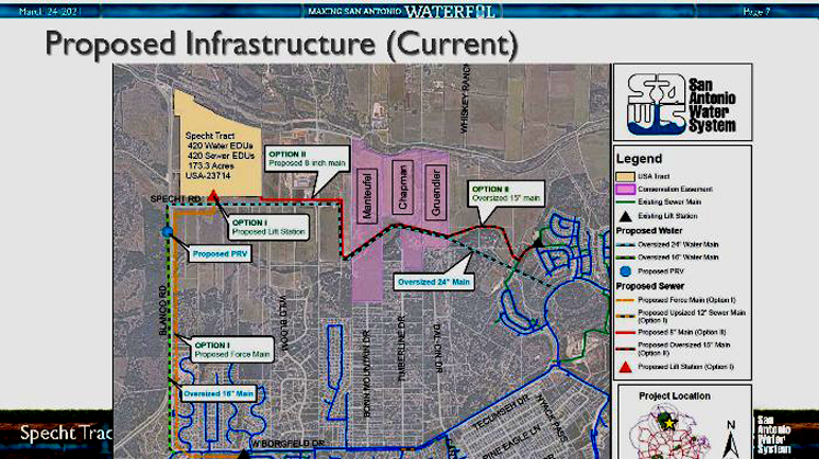
Further research revealed that the SAWS Board had approved a Utility Service Agreement to provide water and sewer service to the Specht tract on June 9, 2020. This agreement entailed a plan to provide sewer service without crossing the EAPP easements.
Board not told about protected land
At their meeting of January 12, 2021, SAWS staff asked for an amended route for the sewer lines while neglecting to mention that the option proposed would require laying sewer lines through the EAPP easements. A motion to approve passed unanimously.
On May 4th, the SAWS Board agenda included further discussion of this issue. From their remarks, it was clear that the Board members were concerned that they did not receive a briefing on all aspects of service to the Specht tract. The Board asked for SAWS staff to provide a risk assessment on all options for providing sewer service to the tract. Since they were not apprised of all the facts in this matter, some questioned whether their approval of the SAWS service agreement was valid. You can read Greater Edwards Aquifer Alliance's (GEAA) comments to the SAWS Board here.
In a quote from the San Antonio Express-News report “'There's a lot of red flags' - SAWS Board holds project that puts pipelines through protected areas” SAWS Vice President Communications & External Affairs, Gavino Ramos said, “There will be no development on the actual conservation easements, but pipes will run underneath.” Seems he doesn’t understand the concept of aquifer protection. You can read additional reports from the San Antonio Express-News here and the San Antonio Report here.
Advisory board raises concerns
There were lots of good questions asked at a discussion of this item at the meeting of the EAPP Conservation Advisory Board on April 28th. You can read GEAA’s comments here.
Members of the EAPP CAB and the SAWS Board seemed concerned that this SAWS service agreement sets a precedent. As well they should be. Never before has the City approved running SAWS utility lines through an EAPP acquired conservation easement. A decision in this matter will influence future treatment of our EAPP lands - sites that were intended to be protected in perpetuity.
SAWS must implement coherent aquifer protection policies
This issue puts a spotlight on just how problematic is the lack of coherent policy when SAWS service seemingly conflicts with our City’s goals for Aquifer protection. GEAA has for many years asked our Mayor and City Council to convene a task force to provide direction to SAWS about the impacts of SAWS water and waste water service on encouraging growth over the Edwards Aquifer Recharge and Contributing zones.
We call on the City and/or the SAWS Board to adopt a moratorium on issuing new Utility Service Contracts for water and waste water service on the Edwards Aquifer Recharge, Transition, and Contributing zones until such time as policies more protective of these areas are adopted. It is time for our elected City officials to stop ignoring these matters and provide guidance to our City owned utilities in the form of policy directives that are consistent with all of San Antonio's stated goals and programs.
Please join GEAA in asking Mayor Nirenberg and the San Antonio City Council members to convene a process to determine policy on SAWS role in development and protection of the Edwards Aquifer, as well as recommendations for changes to the City’s Unified Development Code to realize these goals.
by Annalisa Peace, Executive Director, Greater Edwards Aquifer AllianceGrand Canyon National Park: Toroweap Overlook and Vulcan's Throne
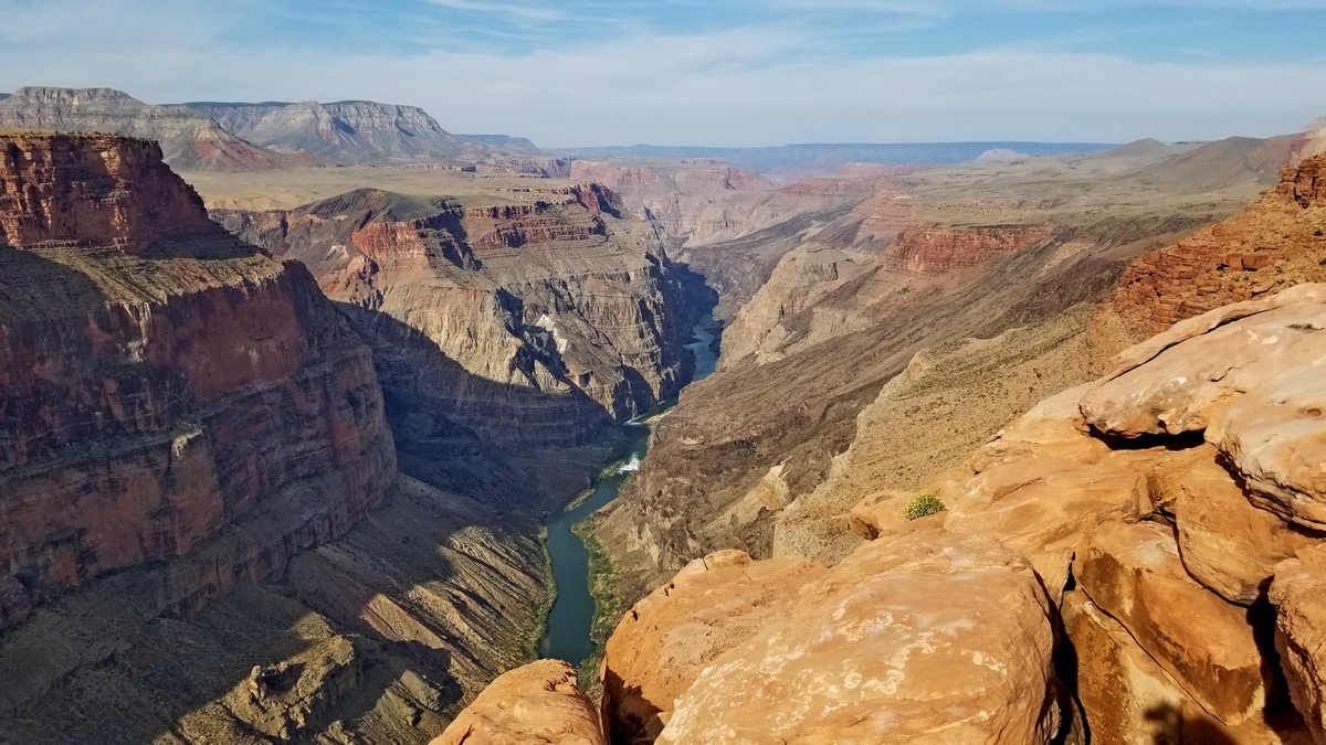
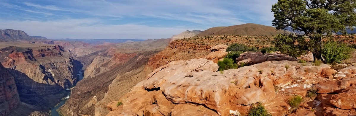
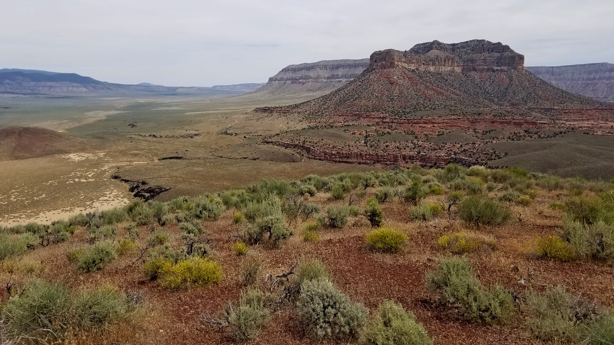
This bit of the park is north of the Colorado River and west of Kaibab National Forest and nearly all of the North Rim park development. Here are the park's Parashant maps and Tuweep web pages. And a high level map of the entire park (PDF); you can see Toroweap/Tuweep at the far left. You drive 45 miles south from Colorado City and AZ hwy 389 to the park entrance station at Tuweep. This is through Grand Canyon-Parashant National Monument, the vast west and north sections of which are run by the BLM. Then it is another 12 miles to a 2WD parking spot. From the latter it was 6.6 miles total past the campground with a loop including Toroweap Overlook, pictures below.
In the above pictures from Toroweap Overlook we are standing on the Esplanade Sandstone. This formation was the background for an article about an area further east in our May, 2021 newsletter.
Toroweap Overlook brings geologic history into view
Somewhere I saw a reference to the Toroweap Fault, which resulted in Prospect Canyon on the south side of the river; where is this? The Wikipedia article has pictures with exactly the vistas in the two above; Prospect Canyon is the big side canyon on the left. A map shows the fault proceeds along the west side of Vulcan's Throne north up Toroweap Valley (Tuweep Valley on some maps).
The geology section (3/4 of the way down) of the park web page (linked above, and from which there is a link to the Geology of the Tuweep Area Bulletin, PDF) says volcanic activity began along the fault 1.2 million years ago, with lava flows filling the valley and occasionally damming the river. The fault is said to be one of the most active in Arizona; it seems likely that fault activity resulted in the relatively recent eruption forming Vulcan's Throne and the pumice/ash slope we can see on the south side of the peak and sloping down to the river.
I didn't entirely understand what I was looking at when taking these pictures. Sure, grand vistas etc, but the fault?
Speculation: did the eruption resulting in Vulcan's Throne dam up not simply the Colorado but a vast side canyon to the north along the fault, like Prospect Canyon to the south? And erosion of sediments from as far north as Mt Trumbull (picture below) further filled in this canyon, leaving Toroweap Valley and Lake? This seems quite possible, as Prospect Canyon reaches the river gorge as we would expect.
Compare with a picture along the Bright Angel Fault in the central section of the park. We can see the enormous side canyons along this fault (within which pass the Bright Angel and North Kaibab trails to the south and north respectively), both directions from the Colorado, which runs right to left across center of the picture. Maybe give the Toroweap Valley drainage another million years and part of Vulcan's Throne and these sediments will have washed down the Colorado, and this side canyon restored.
Driving here can be challenging
I see on the Grand Canyon-Parashant National Monument NPS web page the alert "Looking For A Grand Canyon View? Do Not Follow Cell Phone Navigation App Directions Into Parashant! Phone/Navigation apps are directing people looking for the "Grand Canyon" into Parashant. DO NOT FOLLOW THESE INSTRUCTIONS. Parashant is for 4x4 trucks/SUVs only! No services or cell phone signal in the monument." There are some interesting vehicle pictures on the 4x4 Vehicles and Off-Pavement Travel Safety page and this one as well.
Well, the main road described at the beginning of this article is largely gravel, usually pretty well maintained though sections washboarded. There is another north-south road west of this one which is not gravel and is impassable when wet. There are others elsewhere, likewise highly questionable without 4WD.
Driving in past the park ranger station at Tuweep it is a great idea to stop at the 2WD parking spot (unsigned) a little further on and hike from there (see the link to a map in next paragraph). The "road" further on has 4WD spots and lots of sharp rocks. One web page mentions cases of multiple flat tires per vehicle. It wouldn't be hard to backpack in the 2 miles to the campground with everything needed including water from the 2WD parking spot; there is no water at the campground.
Lots of great hiking and camping
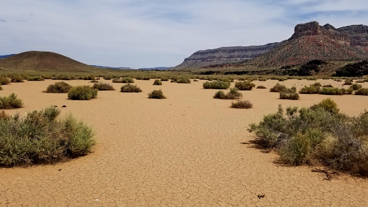
There is a challenging route down the pumice and ash slope on the south side of Vulcan's Throne to the river, 2 miles and 1/2 mile elevation change each way, but driving to the trailhead would also be a real challenge. Here's an article on the trail. The topo map from a link in that article shows "alternative trailhead parking" which is the 2WD parking area mentioned above. And here is another article on climbing Vulcan's Throne across Toroweap Lake, total 4 miles (3rd and 4th pictures above).
There are plenty of at-large campspots in the national monument north of Tuweep; I've used a couple on the east side of Mt Trumbull (in the 3rd picture). No services south of Colorado City. For this trip in June 2020 the Tuweep campground was closed due to COVID-19; I didn't see another person or vehicle all day south of the Tuweep ranger station. Perfect!
by Kevin Hartley, Alamo Group Outings leaderFrom the e-Mailbag
From time-to-time, the Alamo Group receives messages concerning local environmental issues. If you have thoughts to share on any of these issues, send me a message and I'll forward them to the writer.
Leave habitat for Woodlawn Lake birds
Editor's note: the Woodlawn Lake Eco Alliance submitted the following letter to City leaders.
Re: Noise Advisory at Woodlawn Lake
Honorable Councilpersons Sandoval and Trevino, and Staff,
The noise and lights which are being used to frighten away egrets from Woodlawn Lake also frighten all but the most adaptable birds. When we have had mallards and coots, scissortails and night herons, we will wind up with Egyptian geese, pigeons and grackles.
Please leave habitat for our wildlife at Woodlawn Lake Park! The noise, the excessive removal of cattails, the harmful pruning of the largest and lowest branches from cypress trees takes away suitable habitat.
Instead, plant native riparian plants which act as water filters, like cattails. Plant understory trees and shrubs for cardinals and American redstarts. All these species have been seen there over the years. Perhaps the benign neglect of the park was beneficial for wildlife.
If the pandemic has taught us anything, it is that we need the outdoors, more than ever. We need green spaces, places that are as wild as an urban area will allow. We can do it! This fair City treats Salado Creek and the San Antonio River corridors as wild places, planting native plants and ridding the area of invasive species.
If we want to keep our neighborhood viable, we need to clean the lake water with biofiltration plants. We need to allow native wildlife a place to thrive. We can continue to allow the Lake to be nothing other than a drainage area for the City. Or we can treat it like the wild place it could be with the right environmentally sound care, not just management, but care!
There is room for wildlife and room for humans at Woodlawn Lake Park.
P.S. Why can't the planes fly above the flight area for birds?
from Rita Maria Contreras Avery
Outings: The Call of the Wild
Visit the Alamo Sierra Club Outings page on Meetup for detailed information about all of our upcoming Sierra Club Outings.
The Alamo Sierran Newsletter
Richard Alles, Editor
Published by The Alamo Group of the Sierra Club, P.O. Box 6443, San Antonio, TX 78209, AlamoSierraClub.org.
The Alamo Group is one of 13 regional groups within the Lone Star Chapter of the Sierra Club.
Changed your contact information?
If you're not sure whether the Sierra Club has your current email address, send an email to Member Services with your name and address and/or member ID (see Locating Your Member ID) so they can add your email address to your member record.
Have you moved? Let us know by sending your old address, your new address and your member ID to: address.changes@sierraclub.org.
Go online for the latest news and events
 |