Alamo Group Elects New ExCom Members
The Alamo Group's Executive Committee is comprised of volunteer leaders who are elected by you, the Sierra Club's members. They help guide the Group and deal with important strategic and administrative decisions that allow us to achieve our objectives.
Our membership recently voted in 2 new Executive Committee members, Stephen Avery and Joe Yakubik. They also returned Darby Riley to the committee for another term.
Darby Riley has been practicing law in his native San Antonio since 1976. He is married to Chris Riley (mayor of Leon Valley) and they have three grown children. He has been an active volunteer on environmental issues for many years and serves as the Alamo Group's Political Chair.
Stephen ‘Steve’ Avery, long-time member of the Sierra Club and the Nature Conservancy, has advocated for urban environmental issues for most of his adult life. As a successful businessman and investor in residential housing in the inner city, he was a proponent of higher urban density on the City's Board of Adjustments.
With San Antonio’s Open Space Advisory Board, Stephen advocated for more green space and linear parks, and as a member of the Citizens Advisory Panel for the SAWS Board, he spoke for under-represented citizens on environmental justice in infrastructure creation and fair rates for all. Closer to home, Steve was a founding member of the Jefferson Woodlawn Lake Community Development Corporation. As President of the Woodlawn Lake Community Association, Steve spearheaded tree plantings and native wildflower/meadow creation in what has become one of the most-used parks in the city.
Joe Yakubik moved to San Antonio, Texas in 1998 while serving in the Air Force and is currently an electrical engineer. Interests in gardening, bicycling, and hiking created an increased awareness of the changes in climate and the need for action to mitigate these effects. Locally, he has served on the San Antonio Water System (SAWS) Rate Advisory Committee and the City Public Service (CPS) Citizens Advisory Committee as a City Council appointee.
by Richard Alles, Newsletter EditorIn Memory of Gay Wright
One of the Alamo Group’s most active members, Gay Wright, died on January 7 after a prolonged illness. Gay was unstinting in her volunteerism, rarely turning down an opportunity to table an event or attend a meeting.
She also wrote a number of letters to the Express-News editor that were published. Shortly before the onset of the infirmity that eventually took her life, Gay walked the Martin Luther King march with other Sierrans, keeping up with much younger people. Before her illness Gay arranged for a green burial of her body.
by Loretta Van Coppenolle, former Executive Committee member and Conservation Chair50 Years of Conservation: The Story of the Bamberger Ranch Preserve
Our February general meeting features ecologist Jared Holmes, who will tell us about the environmental restoration of a large Hill Country ranch.
Tuesday, February 15, 2022
6:00 p.m.
Online via Zoom
RSVP
To receive an email with the information you need to join the Zoom meeting, visit our event page and submit the RSVP form.
Program topic
In 1969, J. David Bamberger sought to buy the worst piece of ranch land he could find in the Hill Country, with the specific intention of restoring it back to functional health. Over the ensuing 50+ years the 5,500 acre ranch in Blanco County has become one of the largest habitat restoration projects in the state, winning numerous awards.
With the removal of many of the Ashe juniper and the replanting of native grasses, long absent springs are now constantly flowing. Overflow from this spring along with other smaller springs and seeps produce the headwaters of Miller Creek which flows into the Pedernales River, and thence into the Colorado River.
Join us to learn about the history of the ranch, as well as some basic stewardship principles on working with the landscape.
About our speaker

Jared Holmes is an American Ecologist and Zoologist. Jared attended Texas A&M University to further pursue his studies in zoology focusing on snakes and lizards.
He was hired by the ranch full-time in 2014 as a staff biologist. Now, as the Director of Education, Jared works to coordinate the educational programs conducted on the Bamberger Ranch Preserve.
He has authored scientific papers, pamphlets, and manuals on a variety of subjects dealing with the natural world. He has been a contributing scientist on the PBS Show NOVA, featured in TV episodes on the Outdoor Channel, and on various podcasts. More importantly, he has been educating land owners and underserved children for over 15 years on the importance of nature and ethical land stewardship. There is more information about Mr. Holmes and this program on our event page.
Our general meetings are held the 3rd Tuesday of most months. They're always free and open to the public.
Helotes Canyon Watershed’s Future at Stake with Guajolote Tract Decision
Editor's note: This story was written before San Antonio Water System trustees voted, on February 1st, to supply water for 3,000 new houses in the Guajalote Tract. Read the E-N story "Decision by SAWS upsets residents".
Helotes Canyon northwest of San Antonio has seen its share of small-scale development, but the water in Helotes Creek still flows clear and plentiful as it makes its way downstream toward the Edwards Aquifer Recharge Zone.
But with developer Lennar Homes planning the canyon’s densest development yet — a 3,000-home subdivision on a 1,160-acre property — this could all change in only a few years. Could Helotes Creek become yet another dead Hill Country stream, choked with algae and sediment, bearing greater flooding risk, and channeling stormwater runoff from roads and lawns into the Edwards Aquifer?
Will treated sewage be discharged into the creek?
Since last year, Lennar Homes has been planning its development for the Guajolote Tract, one of the largest undeveloped ranches left in Helotes Canyon. Lennar hasn’t yet said how it plans to deal with the sewage generated by 3,000 new households, but GEAA anticipates the proposal of a wastewater treatment plant that would likely discharge either to Helotes Creek or Chiminea Creek, one of its main tributaries.
Wastewater treatment plants are the ideal sewage treatment proposal in some areas, but they’re just plain wrong for Helotes Canyon. The area is one of the few remaining Bexar County watersheds over the Edwards Aquifer with no sewage treatment plants. In a 2020 City-funded study that considered a range of possible wastewater alternatives along Helotes Creek, Southwest Research Institute scientists concluded that any new wastewater infrastructure, regardless of type, would significantly reduce the quality of water recharging the aquifer.
Impervious cover, downstream flooding are concerns
Not only that, but the blanketing of all this natural ranch land with asphalt, concrete, and rooftops will inevitably increase downstream flooding, affecting property owners who have lived in Helotes Canyon for generations.
As recently as last month, the Greater Edwards Aquifer Alliance has been working to hold Lennar Homes accountable for increased flooding caused by another of its Hill Country projects. In Bulverde, where Lennar recently completed its 4S Ranch development, GEAA and Bulverde Neighborhood Alliance (BNA) had in 2019 filed a notice of intent to sue in an effort to get Lennar to comply with a 2016 agreement to avoid flooding its neighbors and protect a large recharge cave on the property.
The agreement was necessary because, as with the Guajolote Tract, Lennar wanted an overly dense development for the area. In the settlement deal, Lennar agreed to contain stormwater runoff to 90% of pre-development levels. Annalisa Peace, GEAA’s executive director, had expressed hope at the time that 4S Ranch could one day become a showcase of responsible Hill Country development.
When the rains came
Then came a heavy rainstorm in October 2019, when a deluge of stormwater laden with mud and construction debris flowed off of 4S Ranch onto a neighboring property. Clearly, Lennar hadn’t followed the agreement and reduced its stormwater runoff. BNA also caught the developer trying to sell lots in a buffer zone meant to protect the cave, another violation of the agreement.
Last year, it became even more clear that Lennar hasn’t kept up its end of the bargain. A consultant hired by BNA determined that the volume of stormwater flowing off of 4S Ranch onto neighboring properties has only gone up, not down, according to the Dec. 14, 2021, report by engineer Freese and Nichols. Last month, GEAA’s attorney sent a letter to Lennar notifying the developer of its obligations to meet the terms of its agreement.
Lennar has clearly demonstrated that it’s unwilling to take simple steps to avoid flooding its neighbors. That’s another reason why GEAA is recommending that the developer create a plan with a density that’s more appropriate for the Guajolote Tract. With residential lots large enough to accommodate septic systems, there would be no need for a wastewater treatment plant discharging to Helotes Creek.
Guajalote and the North Sector Plan
Principles of environmentally conscious growth are embedded in San Antonio’s North Sector Plan. Currently, the North Sector Plan designates that Guajolote Tract as “country” for residential land use, meaning “large tract detached single-family housing; served by well water and septic systems; lots greater than 10 acres.”
We at GEAA had originally thought the Guajolote Tract couldn’t be developed to Lennar’s specifications without the developer having an amendment to the North Sector Plan approved by City Council. If it were inside City limits and the property needed re-zoning, that would be the case. But, according to our own research and indirect confirmation by City staff, the North Sector Plan will not hold regulatory weight in this case.
That’s a shame, because crafting a document like the North Sector Plan is no easy task. It requires dozens of people, many of whom vehemently disagree with the others’ notions of the best possible future of our community, to sit in a room together for hours and reach compromise. That’s what happened in 2010, when City officials and stakeholders sat down to haggle out the document that would outline the next 35 years of growth on the North Side.
San Antonio’s North Side is its fastest-growing sector, but it’s also the most environmentally sensitive area when it comes to the security of the city’s drinking water supply. Developers are paving over and upstream of the delicate Edwards Aquifer Recharge Zone, where rain that falls on the surface flows through cracks, holes, and fractures into the groundwater below. Because of these conduits and its location just west of San Antonio, aquifer scientists estimate that Helotes Canyon is one of the most significant recharge areas for the San Antonio Water System’s Edwards Aquifer supply.
The North Sector Plan included safeguards meant to discourage rampant, overly dense development over the Recharge Zone. Volunteers who served on the stakeholder groups, including representatives of the building and development trades, agreed that growth could be managed responsibly, without sacrificing clean drinking water.
Unfortunately, the City has allowed developers to repeatedly undermine the vision of the North Sector Plan. Since 2010, City Council has approved 85 changes to that plan, proposed by developers who would prefer to not comply with these rules. Read this excellent report by GEAA researchers Juliet Sikorski and Cheyanne McDaniel to learn more about this trend.
What’s the point of spending all this time and effort creating a North Sector Plan, then turning around and undermining it through amendments? This type of behavior by government neuters public participation and increases civic apathy. Why would anyone volunteer their time and input seeing a plan all the way through City Council approval, only to later see that plan undermined?
On Jan. 3, GEAA and nine of its member groups, including the Scenic Loop – Helotes Creek Alliance representing Helotes Canyon residents, sent a letter urging City Council to deny any attempt by Lennar to amend the North Sector Plan in a way that could make it easier to cram a dense subdivision onto the Guajolote Tract. We think it’s important that developers see how their actions will likely affect their downstream neighbors, not to mention the millions who rely on the aquifer for clean drinking water.
by Brendan Gibbons, Assistant Manager, Greater Edwards Aquifer AllianceFrom the e-Mailbag
From time-to-time, the Alamo Group receives messages concerning local environmental issues. If you have thoughts to share on any of these issues, send us a message and we'll forward it to the writer.
The views and opinions expressed here are those of the authors individually and do not necessarily reflect the views or opinions of the Alamo Group or its members.
Council gives Microsoft OK to destroy thousands of trees
January must have been "tree destruction month" as the interwebs were ablaze with comments on the subject. One front page story in particular, Microsoft given OK to remove massive number of trees for data center, raised the ire of Sierrans. By approving a huge variance for this $2.2 trillion corporation, City Council enabled destruction of over 2,000 significant trees and 18 of 19 heritage trees on the land. Comments received included:
Nature doesn’t have a chance in San Antonio! Climate change will repay us for our actions in the future!
I read in the San Antonio Report that over 2,000 trees will be sacrificed to build a Microsoft data center that will likely get discounted electric rates while the citizens of San Antonio are paying higher rates. The tree ordinance that exists was a compromise with the development community for the maintenance a fraction of heritage trees and significant trees with the sacrifice of young trees and understory that is part of a healthy natural world.
The apparent justification for this variance is what I have termed 'real estate socialism'. It is the destruction of a functioning natural world for real estate values of a neighborhood. The world is an ecological crisis due to these types of decisions that create flooding, heat island effects, global climate change, etc.
Tree removal proposed in Brackenridge
CoSA Parks & Recreation's plans to destroy trees in Brackenridge Park were especially unpopular. It is apparent that at least some of the trees are being removed to drive migratory birds out of the park. Among the many comments we received are these:
What’s a park without birds? Four species that nest at Brackenridge are listed on the state’s wildlife action plan as species of greatest conservation need or SGCN. Targeting any species will impact all the others in a given area. At Brackenridge Park, nests with viable eggs were destroyed in 2020; I documented with photos and video before and after.
It would seem that the attitude of "business as usual" actually keeps their internal modus operandi grounded in outmoded, unscientific disregard for current natural science and, in particular, old attitudes that disregard the current status of endangered or soon to be endangered species and wildlife. Urbanization at all costs, commercialization at all costs, including the sacrifice of a cherished park and now even more valuable "green space" that families can call their own is reflective of thinking that must be completely uninformed with regard to current environmental facts about the future of Earth's environment and ecology. The presence of wildlife and their nesting habits are even more critical in these times when species are disappearing at an alarming rate on a world-wide basis.
Water for sure, is a sacred resource to all, or should be — even to politicians, bird haters, dept. heads/staff. Lambert Beach was Brackenridge Park's epi-center for "modern, progressive San Antonians' summer recreation". I have seen old family pix of it when it was the place to swim, frolic and picnic for San Antonio with the bathhouse, etc. and nothing but pure, clean Edwards Aquifer spring water flowing from present Incarnate Word University on down. And, even if we go back 200 years to the Spanish and then the Texians — how mistreated was the river then as a "disposal"? If you look at the sacred river pictures now, except for some native trees and water flow, it is not much more sacred than the commercial downtown Riverwalk. No natural river bottom and plants; No natural river bank riparian system; and SAWS wastewater effluent piped in replacing the former headwaters.
The next effort parks wants to do is to hire the USDA's wildlife services to blanket the city if you will. I’m attaching the emails we uncovered via a FOIA with discussion of destroying nests with viable eggs and even killing some birds. All of this is being hidden from the public. And the USDAs own warning is that their methods may also harm the public, non-target species and the environment!
They say relocate the rookery, the last rookery in a city park, and all planned out without public knowledge or transparency. In 2018 they sprayed the public with a pesticide for four months. Parks received Notice of violations along with a contractor by the Texas Department of Agriculture. They tried the same thing at Elmendorf Lake Park. Using pyrotechnic explosives, using them in high winds and directed over the parking lot and buildings at OLLU.
City Council: Reject CPS Energy’s Proposed Rate Hike
Editor's note: This story was originally published on January 11th in Decleration News before City Council's January 13th approval of CPS Energy's rate hike. Subsequently, portions of the article were revised for this newsletter.
In America today we privatize profits and socialize losses. CPS Energy’s existing rate structure is how huge profits are created for businesses that use the most electricity at the expense of nearly all residential ratepayers. On Thursday, City Council is expected to vote on a 3.85-percent increase in electricity and gas rates, largely to cover weatherization that should have been done a decade ago to prevent losses like those in Winter Storm Uri. Until CPS Energy enacts fundamental rate reforms and commits to a significant climate response by 2030, Council needs to vote no.
CPS Energy’s current proposal asks for an across-the-board increase in electricity rates, locking in the many inequities built into the current rate structure. That rate structure is the problem, not the solution.
The proposed rates would further inequality by raising residential bills disproportionately while minimizing costs for those residents and businesses using the most energy. The biggest consumers pay much lower rates than the rest of us. All rates for profitable businesses should be high enough to pay their full cost to serve. [Utility retail customer bills have traditionally been based on the cost to the utility to provide service, or the “cost to serve,” including labor and technology, acquiring/creating and transmitting energy to customers, which is then divided by the total number of customers.]
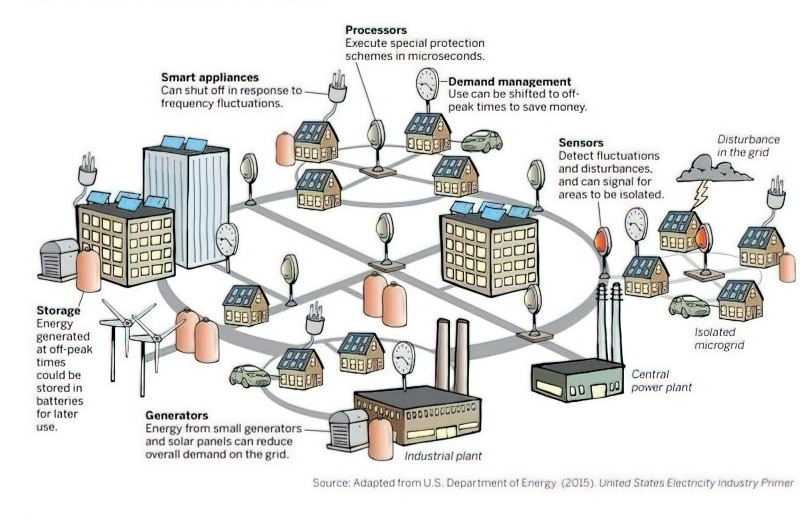
The CPS Board unanimously approved San Antonio’s Climate Action and Adaptation Plan, but two and a half years later CPS is still refusing to commit to reductions of greenhouse gases by 2030, a milestone necessary to avoid the worst impacts of climate change. City Council has the authority to set policy requiring the rate structure to promote both significant reduction of electricity usage and investment in Distributed Energy Resources (DERs), like solar arrays and battery storage. These distributed systems are crucial for creating local microgrids that both supply energy and stabilize the grid during severe weather events.
CPS appears eager to embark on a costly transformation of Spruce 2 coal unit into a gas-fired power plant, ensuring more decades of greenhouse gas emissions. Is it prudent to borrow money to build another fossil fuel-intensive power generation facility with a 40-year lifespan if a federally mandated price on carbon will almost certainly be in place long before 2040? Not accounting for that now leaves CPS at high risk of stranded assets and unpaid debt.
The City Council and the Mayor must not shirk their responsibility to the people of San Antonio. The City Council has the authority to hold our public utility accountable for failure to protect people from Winter Storm Uri. As Uri and many historic heat waves have shown, people die when they don’t have electricity to keep warm or cool.
Until there are significant reforms at CPS, City Council must reject rate-hike requests and insist CPS expand the weatherization of all older housing, especially in low-income neighborhoods.
To better understand how CPS is doing business, Council must require CPS to reveal details (not just averages) about residential energy usage. There are three rates for residential electricity usage, but only one (RCE, Large-Use Residential Capacity Energy) is designed for rich residents who use inordinate amounts of electricity.
Instead of a rate structure that promotes conservation and energy-efficiency, the RCE rate encourages heavy usage and waste. CPS justifies this by saying, in a recent presentation to the CPS Rate Advisory Committee: “The higher the use, the more likely a residential customer will cover the total cost to serve.” Councilmembers: Don’t let CPS hasten climate chaos with such backward thinking!
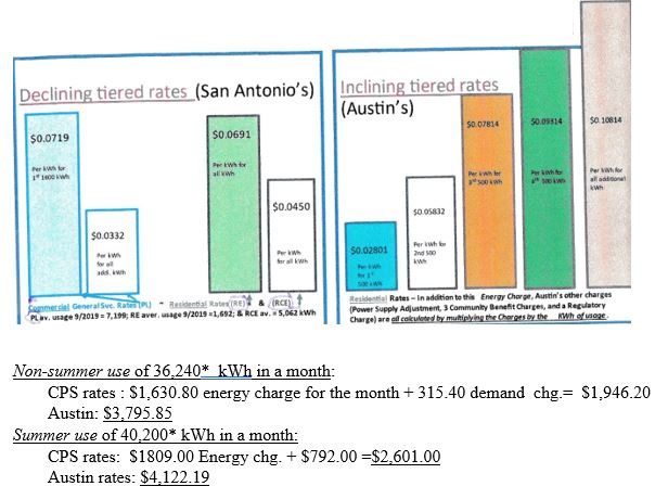
It is appalling that a special rate for wealthy residents using the most energy (at $0.0450/kWh) is much lower than basic RA (Residential All Electric) and RE (Residential Electric) rates for the rest of us (at $0.0691/kWh). Basing the “cost to serve” on average amounts of energy use rewards the highest users with unfair breaks while forcing the more energy-conserving (and often low-income) customers to pick up the tab for those breaks. Since RCE ratepayers pay much less per kilowatt hour than others, all non-RCE customers are stuck subsidizing wasteful customers.
RCE ratepayers use thousands of kilowatt hours per month more than the average customer. Why does it matter? If all residential ratepayers dropped their usage below 1,500 kilowatt hours per month (kWh/mo), CPS could retire air-polluting Spruce 1 without needing any replacement generator.
In contrast to the CPS model, Austin Energy has an inclining tiered rate structure that rewards those using less than 1,000 kWh/month but penalizes those using over 1,500 kWh/month and 2,000 kWh/month.
During February’s deadly blackouts, some energy-intensive businesses on working circuits remained open and consumed lots of power through the crisis. That electricity was for producing profit. Council should require CPS to reveal details about amounts used by the heaviest demanding businesses (ELP-Extra Large Power and SLP-Super Large Power), including identifying which businesses were on open circuits during blackouts and for how long. Those businesses must pay their proportionate share of CPS’s outrageously high winter storm bill. No residential ratepayers should have to subsidize those highly profitable businesses.
Council must ask pointed questions: Exactly why is CPS’s current rate for the largest industrial users (the SLP category) so miniscule — a mere 16 percent of the cost it takes to provide them service? Under the current proposal these heavy users would only pay for 30 percent of that cost. See below:

Why have those profitable businesses been paying such tiny amounts of their costs all along when struggling residential ratepayers are going from 40 percent to nearly 70 percent under the proposed rate hike?
Why is our public utility hurting residential ratepayers with greatly increased fixed charges, while profitable SLP business customers are not even providing many good jobs?
City Council has the authority to demand reforms to CPS Energy’s rate structure and hold CPS accountable. Make CPS deliver on its own motto: “People First.”
To keep SA’s people first, CPS must provide essential quantities of energy necessary to keep people safe, alive, and well during extreme weather events. Essential utilities must be available to all households, regardless of their ability to pay costs.
The City Council should postpone approval of any part of CPS Energy’s requested rate increase until CPS:
- takes responsibility for its failure to adequately protect the residents of this city and cover their existing needs through by cutting frills like travel, entertainment, and executive perks;
- limits proposed residential ratepayers’ rate hike (including fuel adjustment charges) to usage greater than 1,500 kWh (kilowatt hours) per month, and requires profitable businesses using the most energy to pay at least 90% cost recovery;
- cooperates immediately in a thorough Rate Allocation Review with a recognized outside, impartial, and Council-approved organization with experience shaping rate structures that protect vulnerable low-income communities, followed by an Interim Rate Case;
- commits to a fully equitable rate structure that promotes significant climate action, to be put into effect by January 2023;
- commits to beating the City of San Antonio’s greenhouse-reduction goals of nearly half of energy-related emissions by 2030.
These data above were described by the Decleration News editor:
High residential users of the RCE class described above also pay a per-kilowatt “demand charge” of $8/kW in the summer months and $3.80/kW the rest of the year. While this starts to narrow the gap between what the richest San Antonians pay compared to other residential users (particularly in the summertime), the gaps remain large.
For instance, comparing the per-kilowatt cost for electricity used plus CPS demand charges included in two sample bills provided to RAC members recently showed a summertime savings for the RCE users of $176 for a summer month over a typical residential bill and more significant $1,259 undercharge (when compared with a typical residential user) for a non-summer month.
Hardly ever (perhaps never) is the RCE rate category mentioned in the news or explanation of CPS rates, perhaps because the utility does not want the Council to know that the RCE rate creates substantial discounts for Residential class customers who use far too much electricity. Comparing CPS rates with Austin’s, as applied to RCE level of usage shows how much better Austin Energy’s inclining tiered rate is for apportioning the "Cost to Serve" both fairly and effectively, resulting in strong incentives to use far less electricity. The authors of this article doubt that “sample bills” presented to the RAC were actual bills for a real customer, because --even in SA’s biggest mansions, it would be difficult to use so much electricity so many months a year.
Postscript
After the City Council vote, District 5 Councilperson Teri Castillo wrote for the Express News a very compelling essay — Why I voted against the CPS Energy rate increase — about her decision to vote no.
Our San Antonio group of the Sierra Club will be working hard for rate-structure reform both at CPS and SAWS. San Antonio needs our businesses and residents to reduce their water and energy usage, so we become better prepared for climate change-induced weather extremes, like long-lasting heat waves and extreme winter storms.
by Meredith McGuire & Alfred Montoya. Dr. Meredith McGuire, now retired, taught sociology and anthropology at Trinity University. Dr. Alfred Montoya was born and raised and currently resides on the city’s West Side. He is a medical anthropologist and associate professor at Trinity University.The Kaibab Plateau, North of Grand Canyon National Park and The Lesson of the Kaibab
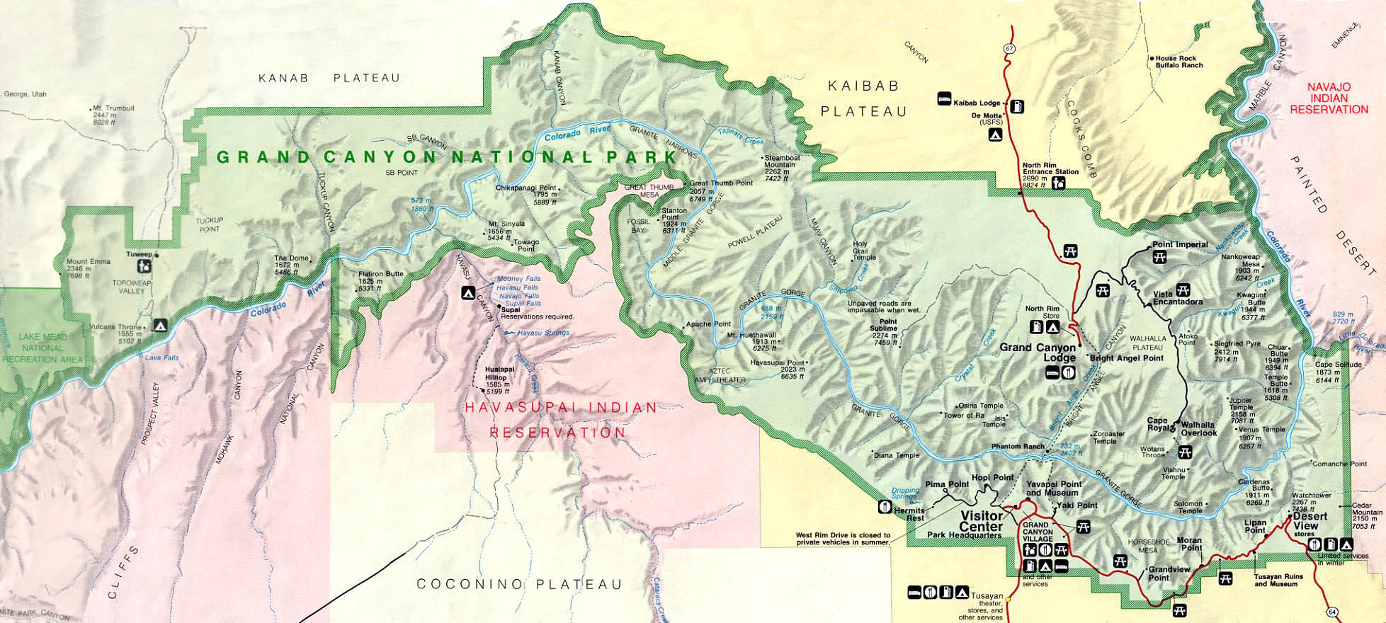
The Kaibab Plateau is why the Colorado River makes a 50-mile detour to the south between Lake Powell and to the southwest of Steamboat Mountain (2nd picture below). Driving across the plateau you are in Kaibab National Forest until close to the gorge of the Colorado, where it becomes Grand Canyon National Park.
The drive to the developed area on the national park North Rim area is south along AZ Hwy 67 across the center of the plateau. This passes close to the high point (9200') of the plateau (Wikipedia) which is a big uplift a bit southwest of the center of the much larger Colorado Plateau (Wikipedia).
Here is a high level map of the whole area; no detail. But we can see the national park boundary and that of the national forest north section, and Grand Canyon-Parashant National Monument to the west. Correlating with a better map we can pick out some key spots mentioned below and in the January 2022, December 2021 and May 2021 issues of this newsletter. The December 2021 issue article mentions that these vistas include many buttes and peaks named by geologist Clarence Dutton, and how we can often figure out what we are looking at.
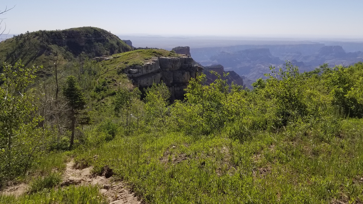
The first picture below is in the far northeast corner of the plateau, on a hike from Point Imperial in the national park. Near here I heard ethereal music, maybe accordion? No other sounds at all. Then saw a couple on the viewpoint center, therefore the music; on passing they seemed to express guilt for possibly violating Leave No Trace Principles, but I said I was entranced, and of course there was no trace afterwards.
This is in Saddle Mountain Wilderness. The trail was through miles of totally burned forest, no trees larger than 15' or so, but the vegetation is recovering well. I couldn't identify when this fire might have been, but there have been some in recent decades and surely will be more.
Yet more vistas
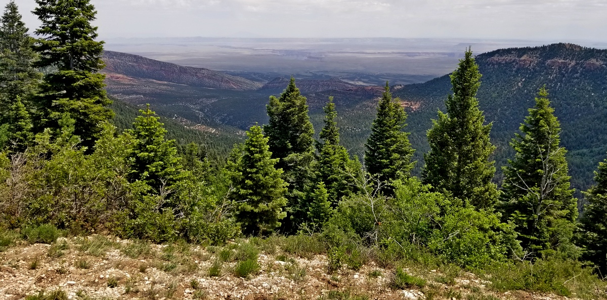
Timp, Fence, and Parissawampitts viewpoints lie along the Rainbow Rim trail (next picture below). This web page has pictures of more vistas taken from the trail.
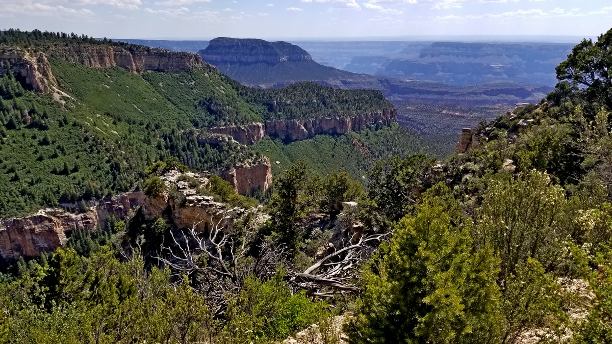
A vista photo taken from the East Rim Trail is the 2nd picture below. This trail travels along the west and east rims of the Kaibab Plateau.
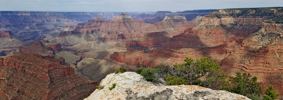
There are some other viewpoints that can be reached by navigating cross-country, largely without trails, where there are traces of abandoned roads. One example is in the last picture which was taken from Honan Point (here's a page with more pictures), which is west of Cape Royal at the south end of the Walhalla Plateau, which itself is a thumb attached to the southeast corner of the greater Kaibab Plateau.
This is about 6 miles round trip from the Cliff Spring trailhead if you pay attention as regards navigation. There are also Komo and Francois Matthes points nearby, and Tiyo Point which is just west of Widforss Point.
The Lesson of the Kaibab
This is the title of some biology education materials found on the Internet (example). In 1905, the population of mule deer on the Kaibab Plateau was estimated at 4,000. The carrying capacity of the plateau was estimated, by Aldo Leopold and others, to be 30,000 to 40,000.
Leopold surely regretted that early work later in life; see an article in the March 2021 issue. Why so few if the capacity was so large?
Predation was supposed to be the problem; so in 1906 Theodore Roosevelt established the Grand Canyon Game Preserve on the plateau “to protect the most important deer herd in America”. Between 1907 and 1939, 816 mountain lions, 20 wolves, 738 coyotes and over 300 bobcats were killed.
Roosevelt himself shot one of the last remaining mountain lions. The deer population exploded; there may have been 100,000 deer on the plateau by 1924. The vegetation was severely overgrazed and many of the deer starved to death. See the chart on this webpage.
A lot of this detail is at the end of the Wikipedia Kaibab Plateau article. Roosevelt did many important things to protect public lands but this was not one of them.
Food for thought
Our remnants of wilderness will yield bigger values to the nation's character and health than they will to its pocketbook, and to destroy them will be to admit that the latter are the only values that interest us.by Kevin Hartley, Alamo Group Outings leader
- Aldo Leopold
Less is More, Turning Range Anxiety into Energy Awareness
I live in San Antonio and drive a small Mitsubishi I-MiEV battery electric vehicle (EV). It has a range of about 60 miles on a full charge.
I use the I-MiEV to get around town. I find that the I-MiEV, even with limited range, accomplishes 95% of my in-town trips. Because of the limited range, I plan my trips carefully. I charge primarily at night in my driveway and occasionally charge as needed at select locations. Because there are no startup/warmup emissions as with gasoline or diesel vehicles, I don’t worry if I need to drive it for short jaunts.
The I-MiEV has a digital display of the remaining range, effectively the distance till the battery is depleted. I keep an eye on this display as I drive and it has been quite an education. The gauge displays remaining range in miles or kilometers and factors in the existing load on the vehicle. When I turn on the air conditioner or cabin heater, or increase my speed on the highway, the remaining range goes down quickly! When I first began driving this car, the display engendered a great deal of range anxiety.
As I accumulated experience driving the I-MiEV, I gained some interesting perspectives. The limited range has taught me to combine trips to be more range-efficient. A typical trip almost always involves engaging members of my household in a conversation to determine if they need anything in the vicinity of my planned trip. If the answer is yes, I can eliminate a separate trip. Transportation professionals term this “trip chaining” and estimate that this practice can reduce vehicle miles travelled 20 to 50 percent.
In order to increase my effective range, I frequently avoid using the air conditioner and cabin heater. EV’s don’t generate as much waste heat as internal combustion engines, so heating must be accomplished using battery energy. As an alternative to using the heater in cold weather, I use the heated driver and passenger seats to increase comfort. If it’s particularly cold I wear an additional coat and/or hat.
If the weather is hot, I roll the windows down for a few minutes when I first start driving to cool the passenger compartment. Then I assess whether I can avoid using the air conditioner. This decision is trip-dependent, based on ambient temperature, insolation, remaining range, trip length, and the clothes I am wearing at the time. If I were driving a gasoline vehicle with effectively unlimited range, my threshold for using the additional energy for the air conditioner would be substantially lower.
The limited range of my I-MiEV has influenced the route I take for specific trips. I find that usable range decreases substantially if I choose higher-speed highways as opposed to slower-speed city streets. At first this concerned me because I thought a city street route would substantially increase the time required for each errand. As I gained experience, however, I found that I avoided many traffic delays on the highways, particularly at rush hour, and that transit times were about the same. I still have to plan the route carefully and take street construction into account.
There’s an added benefit to avoiding highways that was not apparent at first. I arrive at my destination less frazzled by high-speed traffic and the defensive driving stance that I have to adopt to travel the highways. I still drive defensively on city streets, but it seems less wearing on my psyche. When I drive a gasoline-fueled vehicle I seldom ponder the route. I am more likely to take the fastest way, regardless of energy consumption or emissions considerations.
The limited range of the I-MiEV has helped me turn range anxiety into energy awareness. Lower range EVs are a perfect fit for in-town trips and short commutes. I highly recommend them!
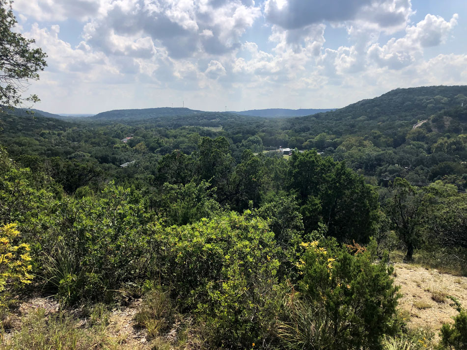
by Alan Montemayor, Alamo Group ChairRolling Hills, Spring-fed Rivers, Wildlife... or a Moonscape?
I’ve always known I wanted to come back to central Texas to live out my days. In 1996, we found our little slice of paradise here in Comal County. We purchased five acres of land surrounded by all that I had come to associate with the Hill Country.
We would be nestled amongst oak, cedar, and elm trees with an abundance of wildlife, birds, bats, and insects. To the west-northwest sat the beautiful White Ranch.
We planned, we scrimped, we saved and in 2016 we completed construction of our forever home. But soon came word that the White Ranch had been sold to Blue Pine Holdings, Inc. Turns out that Blue Pine is a shell company owned by Vulcan Construction Materials, LLC. and they have plans to turn the White Ranch into a quarry.
What is to become of our beloved Hill Country & Comal County?
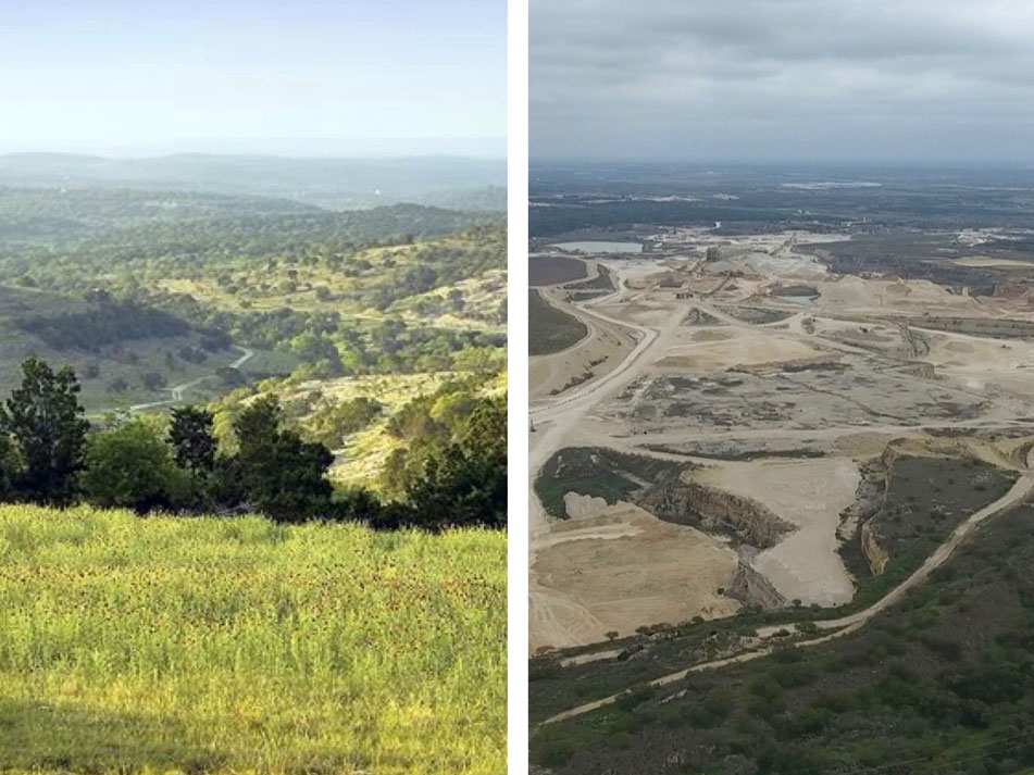
The White Ranch, 1500 acres (2.3 square miles) of pristine Texas Hill Country rangeland, sits in the middle of Comal County amidst caves, rivers and streams, wildlife, and fauna. The ranch sits under the migratory paths of bats, monarch butterflies and whooping cranes. Numerous legacy ranches and homesteads are nearby along with Indian remains and artifacts on neighboring properties and in adjacent caves.
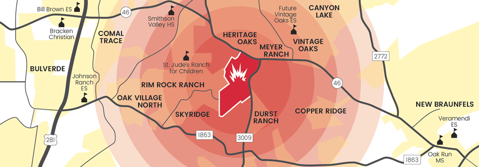
Proposed quarry is over aquifer recharge zone
The property extends southwest nearly three miles from the corner of State Highway 46 and Farm-to-Market 3009. This land is one of the largest pieces of undeveloped property in the county and is in unincorporated territory midway between New Braunfels and Bulverde. Of the utmost concern, White Ranch rests entirely over the Edwards Aquifer Recharge Zone (EARZ), and is unfortunately, in the crosshairs of the aggregate production operation (APO) industry in Texas.
To understand the concerns of a quarry in the middle of the EARZ there needs to be a basic understanding of how a karst aquifer works. Karst is a terrain formed by dissolution of bedrock – in our area this bedrock is limestone. Common features of limestone bedrock are sinkholes, caves, underground streams, and large streams or aquifers. Precipitation provides the surface water that feeds the karst aquifer system.
Karst is fractured and the millions of cracks and crevices form conduits through the limestone. As water enlarges these conduits, they capture more water, growing at ever-increasing rates until large enough for human entry. This is how Natural Bridge Caverns and Bracken Bat Cave were formed.
The water continues through these conduits to the underground streams or aquifers. Prime example, the largest artesian spring in Texas is here in New Braunfels, Comal Springs.
Pristine creeks could be polluted
Not only does the White Ranch sit atop the EARZ but the West Fork Dry Comal Creek runs through it, converging downstream with the Dry Comal Creek before merging with the Comal River in New Braunfels. The Comal River is fed by springs from the Edwards Aquifer and is home to several endangered species. The clear, temperate waters of the Comal are widely used for recreational swimming and tubing activities before discharging into the Guadalupe River. Dry Comal Creek and Comal River are essential natural resources in Comal County, supporting economic development and recreation in the city, as well as agricultural operations and wildlife throughout the area.
The portion of the West Fork Dry Comal Creek that runs through White Ranch is the only section of the Dry Comal Creek and Comal River watersheds that is not polluted. In 2010, TCEQ listed the Dry Comal Creek for impairment to its designated contact recreational use due to elevated Escherichia coli (E. coli) concentrations.
Each of these water systems has a bearing on the other. The Dry Comal Creek and Comal River watersheds are also experiencing rapid urbanization, which adds another basis of pollution. Karst is vulnerable to pollution and the relationship between its many features, - creeks, streams, aquifers, and caves are complicated.
Comal County has numerous waterways – Dry Comal, Cibolo, Rebecca, and Honey creeks; Comal and Guadalupe rivers; Comal and Hueco springs, the Trinity and Edwards aquifers; and Canyon Lake. If any of these water sources becomes polluted or is irreparably harmed, the others are in danger as well.
A quarry sitting in the middle of all these water resources would present numerous challenges to these many interlinked systems, leaving our community exposed to water quality and quantity sustainability issues.
Area residents have fought for years
In 2017, Vulcan applied for an air quality permit with the Texas Commission on Environmental Quality (TCEQ). Area residents banded together to create an all-volunteer grassroots organization to contest the scientific and factual validity of the permit. Preserve Our Hill Country Environment (PHCE) and PHCE Foundation DBA Stop 3009 Vulcan Quarry and Friends of Dry Comal Creek were born.
- February 27, 2018, TCEQ held a Public Meeting at the New Braunfels Civic/Convention Center. Over 500 residents, local and state leadership, and media showed up to support our efforts, voice their concerns and submit public comment for the permanent record.
- December 2018, TCEQ granted our requests for a Contested Case Hearing (CCH) with the State Office of Administrative Hearings (SOAH).
- March 6, 2019, SOAH Preliminary Hearing. There was standing room only in the Comal County Courthouse when the Administrative Law Judge (ALJ) extended the affected party boundary from one to five miles and granted AP status to all who had requested it.
- June 2019, the Contested Case Hearing, lasting 3 days, was held in Austin. In August, the ALJ released a recommendation to TCEQ granting the air permit.
- November 2019, TCEQ Commissioner’s granted the air permit. We filed a motion for rehearing on the permit citing the judge’s lack of consideration on the impact that the quarry would have on air pollution, increased truck traffic, decreased property values, endangered water quantity and quality, and other environmental issues. Also cited was the claim to “trade secret” allowed by the ALJ on Vulcan’s composite core sample used to determine silica content of the mining materials. The rehearing was not granted.
- February 2020, we sued TCEQ in Travis County District Court. We asked the state to reevaluate the permit, noting that the agency ignored important environmental data and made legal errors when it approved the quarry in November 2019.
- December 8, 2020, Hearing presided over by Judge Maya Guerra Gamble. Friends of Dry Comal Creek, Stop 3009 Vulcan Quarry v. Texas Commission on Environmental Quality (TCEQ) and Vulcan Construction Materials, LLC.
- March 6, 2021, Judge Gamble struck down Vulcan’s air permit remanding the permit back to TCEQ. In April, TCEQ and Vulcan appealed that decision to the Third Court of Appeals.
Long story short, we followed the arcane “set to fail” process set forth by TCEQ and now the property’s future is in the hands of Texas courts. TCEQ stood with industry over citizens and issued the permit without adequately considering the impacts on the environment, our natural resources, and the health of the community, as required by state law.
Aggregate product is essential to the growth of Texas, but it is best produced in an industrial setting using common-sense, environmentally protective practices. The White Ranch is not an appropriate location. The sensitive features that comprise the White Ranch and ultimately affect the citizens of Comal County and New Braunfels need to be protected and preserved.
Understand what our Texas Hill Country stands to lose. For more information go to Stop 3009 Vulcan Quarry. Support our cause by attending the Bluebonnet Extravaganza Dinner & Auction or donate at Preserve our Hill Country Environment
by Milann Guckian, President, Preserve our Hill Country EnvironmentIn Memoriam: Thích Nhất Hạnh, 1926-2022
Thích Nhất Hạnh, a Buddhist monk and peace activist, died at his temple home in Hue, Vietnam January 22nd. From the Wikipedia page: "... Nhất Hạnh's relationship with the government of Vietnam has varied over the years. He stayed away from politics, but did not support the South Vietnamese government's policies of Catholicization. He questioned American involvement, which put him at odds with the Saigon leadership, which banned him from returning to South Vietnam while he was abroad in 1966.
He studied at Princeton and taught at Columbia in the US. He met Trappist monk Thomas Merton, who wrote an essay Nhat Hanh is my Brother. In 1965 he wrote Martin Luther King Jr. a letter titled In Search of the Enemy of Man. In 1966 he urged King to publicly denounce the Vietnam War. In 1967 King gave a speech Beyond Vietnam: A Time to Break Silence. King nominated Nhất Hạnh for the 1967 Nobel Peace Prize."
The San Antonio library has a bunch of his 100+ books, including Zen and the Art of Saving the Planet, Being Peace and The World We Have – a Buddhist Approach to Peace and Ecology.
Nhất Hạnh founded Plum Village near Bordeaux, France, in 1982. On their website are a bunch of testimonials, for example “It is not an exaggeration to say Thích Nhất Hạnh writings saved my life and continue to beautify it” and “I'm just a regular guy from Texas. I read about Thay [Hanh] and ordered The Pocket Thich Nhat Hanh. It completely changed my life. I stopped rushing and seeking. I learned to be still and enjoy each moment.”
by Kevin Hartley, Alamo Group Outings leader
Outings: The Call of the Wild
Visit the Alamo Sierra Club Outings page on Meetup for detailed information about all of our upcoming Sierra Club Outings.
The Alamo Sierran Newsletter
Richard Alles, Editor
Published by the Alamo Group of the Sierra Club, P.O. Box 6443, San Antonio, TX 78209, AlamoSierraClub.org.
The Alamo Group is one of 13 regional groups within the Lone Star Chapter of the Sierra Club.
Changed your contact information?
If you're not sure whether the Sierra Club has your current email address, send an email to Member Services with your name and address and/or member ID (see Locating Your Member ID) so they can add your email address to your member record.
Have you moved? Let us know by sending your old address, your new address and your member ID to: address.changes@sierraclub.org.
Go online for the latest news and events
 |