Sustainable Features of Our Home
Our family lives in a mid-century ranch house that was built in 1959. Our home is approximately 1700 square feet in size. We raised two sons in this home, and our current household size is two adults. We have owned the home since 1986, and have made incremental changes during the past 36 years to reflect our desire for a sustainable lifestyle.
Insulate, insulate, insulate
Our first step in improving the energy efficiency of the house was to weatherstrip our doors and windows and add R38 fiberglass blown-in insulation in the attic. We noticed an immediate increase in comfort on hot and cold days and a significant reduction in our heating and cooling costs.
Next, we replaced the original single-pane aluminum windows with double-pane argon-insulated low-E vinyl windows. Again, we noticed an immediate improvement in comfort and further reduction in our heating and cooling costs. As a spinoff benefit, we noticed a reduction in city noise infiltrating into the house and less dust!
Efficient devices
Our next step was to replace our incandescent and fluorescent lighting with LEDs. This brightened up the house, lowered the energy bill and minimized heat from the bulbs to reduce the air conditioning demands in the summer. We now have only three bulbs in the house that are incandescent or halogen: the oven bulb and two reading lights.
As our appliances failed, we replaced them with energy efficient models. This included a refrigerator/freezer, washer, dryer, water heater and air conditioner/heater unit. We utilized a number of energy rebates from our local utility. The biggest energy reduction was replacing our refrigerator/freezer.
Benefits from shade trees
Our home faces the southwest. In our backyard, two heritage oak trees overhang our house and protect our home from cold winds in the winter. These same trees provide shade from the morning and midday sun in the summer, thereby reducing our air conditioning use during the hottest months.
In the front yard, a large bald cypress tree provides shade from the west in the summer and allows the sun’s rays to warm our home in the winter after it has shed its needle-like leaves.
During the summer and on warm winter days we use a clothesline for drying clothes. On colder days, we wear additional layers of clothing indoors and reduce our thermostat to 64 degrees. In the summer, we shed layers of clothing indoors and increase our thermostat to 82 degrees. In the summer, we minimize air conditioning by opening windows at night and closing them as the day warms. We have ceiling fans in every room and occasionally add portable floor fans if needed for better air circulation.
On sunny days we sometimes cook outside with a solar oven. On hot days we often cook on the back porch using a crock pot to minimize heating of the kitchen.
Conserving water
Like almost everyone, we installed low-flow toilets and shower heads several years ago. We also use our air conditioner condensate to water our plants.
The biggest reduction in our water consumption, however, was reducing landscape watering. Every year for several years, we removed another section of our St. Augustine turfgrass and installed water-saving native plants. We chose native plants that are specifically designed to attract insects and other pollinators as well as birds and other wildlife. We transformed a neglected side yard into a native wildflower garden.
We also removed seven species of invasive plants that were already on the property at the time of our purchase. To date, we have removed 85 percent of the turfgrass and have replaced it with four species of native grasses, five species of native groundcovers/vines, nineteen species of native shrubs, four species of native trees and forty-seven species of native annual and perennial wildflowers. We use mulch to prevent moisture loss in the summer and to protect our plants from freeze-damage in the winter.
The National Wildlife Federation has named our yard a Certified Wildlife Habitat. Texas Parks and Wildlife has certified our yard as a Texas Wildscapes Backyard Wildlife Habitat. We are a Monarch Waystation with Monarch Watch and a Monarch Butterfly and Pollinator Habitat with Texas Butterfly Ranch. Last, we are “On the Map” as a Homegrown National Park. These certifications reflect the shift we made from a traditional monoculture turfgrass lawn to a biologically diverse ecosystem with water reduction advantages.
Driving electric
During the past five years, we retired our hybrid-electric first-generation Prius sedans and purchased two, used, electric vehicles.
Our first purchase was a used 2014 Mitsubishi i-MiEV battery-electric vehicle. It is a small, four-seat sedan with a range of 60 miles. The range is perfect for short trips around town. With the i-MiEV, we accommodate the limited range by consolidating trips and charging appropriately. It’s clean and quiet and fun to drive!
Our second purchase was a used 2017 Chevy Bolt battery-electric vehicle. This five-passenger vehicle has a range of 238 miles, which is plenty of range for longer trips.
Typical charging time is 3 to 6 hours using a 120-Volt or 240-Volt plug. We are able to use faster, Level-2 chargers for free at Eco-Centro, Central Library, Pearl, etc. using ChargePoint stations. While traveling, we can connect with fast-charging stations in convenient locations along major highways. At home, our vehicles are charged directly from our solar panels.
Maintenance costs on our electric vehicles are minimal. Consumables include windshield wipers and windshield washer fluid. Brake pads last >100,000 miles due to regenerative braking. Our vehicles have a tenth the number of moving parts of an internal combustion vehicle.
Using CPS Energy electricity rates, our cost is 3 cents/mile to drive, which means that we can drive 300 miles for $9.00. If gas prices are $3.00 per gallon, with an average vehicle getting 30 miles per gallon, the equivalent cost for the same 300 miles in a gasoline powered vehicle would be $30.00.
Generating our own power
Three years ago, we installed rooftop solar panels. This installation became economically feasible due to CPS and Federal renewable energy credits. After hail damage, we replaced our composition shingle roof with a standing seam metal roof. The metal roof facilitated the mounting of 10 solar panels using clips secured to the standing seams. This allowed us to do a zero-penetration installation that maintained the integrity of the metal roof. We selected an inverter that incorporated a level-2 electric vehicle charging system for our two electric vehicles.
Because our energy consumption is so low, our 3.3 kW grid-tied solar energy system supplies more energy on a yearly basis than we consume. Our monthly average cost for electricity and natural gas usage is $9 per month plus the $18 charge for service availability, which is a fixed charge. Our solar panels provide enough electricity for all our household needs and 95% of the charging of our two, battery-powered vehicles. That means that we have driven our two EVs free of refueling charges for almost three years!
Capturing rainwater
Our most recent installation was a 3200-gallon rainwater capture system for our home. We have 3800 ft2 of roof area. With this roof area, a one-inch rain yields approximately 2300 gallons! We installed 6-inch gutters around the perimeter of the roof with stainless steel micro-screens. The screens prevent leaves/sticks/acorns/catkins from clogging the system and minimizes maintenance. We installed two 1600-gallon stainless steel water tanks with the accompanying fill, overflow and water supply piping. A small pump adds water pressure as needed.
The primary goal of our rainwater capture system is to water our 200-square foot, raised-bed, three-season vegetable garden. We use both a drip irrigation system and hand watering. We do not grow vegetables in May, June and July due to temperature extremes.
The secondary goal of our rainwater capture system is to minimize urban runoff from our property. Overflow from the tanks flows into buried drain pipes to slow, sink and spread the water to the roots of native grasses.
We have an outdoor sink that is connected to our rainwater tanks for washing up and rinsing vegetables. We also use our rainwater to refill our bird bath, wash our cars and add water to our passive compost pile to facilitate decomposition.
Planned future uses of the rainwater include an outdoor warm-weather solar heated shower, evaporative cooling of our air conditioner condenser unit (increases efficiency of A/C during hot dry times), and evaporative cooling of our solar panels during hot/dry times to maximize panel output.
Five Rs
As far as purchasing preferences, we Refuse, Reduce, Reuse, Rot and Recycle in that order (R5). We use reusable shopping bags stored in our vehicles. We compost our kitchen and yard waste. We purchase a large percentage of our food from local community supported agriculture and increasingly grow our own vegetables and herbs using rainwater and raised bed gardening. We reuse packaging whenever possible. We fix most things rather than replacing them when they break. We are trying to minimize plastic purchasing and use. We recycle aluminum, plastic, glass and paper.
For 36 years we have been incrementally changing features in our home and yard that increase our resilience to change and reduce our impact on the environment. By reducing water, energy and resource use, we live lighter on the planet. Our lives have become simpler in many ways. Auto maintenance and repairs are greatly reduced. We no longer fertilize, water, edge, trim and mow turfgrass. Our native plant landscape requires very little maintenance and is a haven for wildlife. We enjoy the aesthetic beauty of our yard, local wildlife, fresh herbs and vegetables from the garden and the satisfaction that comes from reducing our ecological footprint.
Come see our home on April 16th
Before Covid, we periodically opened our home to interested visitors, demonstrating the sustainable features of our home. We are now ready to resume in-person tours. The first tour is April 16, 2022 from 10am to 2pm at our home at 152 Bluet Lane. We invite you to join us to see which sustainable features might work well for your home!
by Alan Montemayor, Alamo Group ChairWest Side Rising: How San Antonio’s 1921 Flood Devastated a City and Sparked a Latino Environmental Justice Movement
Our April general meeting features Char Miller, PhD discussing how a Latino environmental justice movement grew out of a flood that killed over eighty people in San Antonio's west side neighborhoods.
Tuesday, April 19th
6:00 p.m.
Online via Zoom
RSVP
To receive an email with the information you need to join the Zoom meeting, visit our event page and submit the RSVP form.
Program topic
On September 9, 1921, a tropical depression stalled just north of San Antonio and within hours overwhelmed its winding network of creeks and rivers. Floodwaters ripped through the city’s Latino West Side neighborhoods, killing more than eighty people. Meanwhile a wall of water crashed into the central business district on the city’s North Side, wreaking considerable damage.
The city’s response to this disaster shaped its environmental policies for the next fifty years, carving new channels of power. For more on this topic, read The Flood that Sparked a Latino Environmental Justice Movement, Sierra Magazine, October 9, 2021.
About our speaker

Pomona College
Char Miller, formerly a professor of history at Trinity University, is the W. M. Keck Professor of Environmental Analysis & History at Pomona College in Claremont, CA. He is the author of West Side Rising: How San Antonio’s 1921 Flood Devastated a City and Sparked a Latino Environmental Justice Movement.
For more information about this program and our speaker, visit our event page.
Our general meetings are held the 3rd Tuesday of most months. They're always free and open to the public.
Changing Rainfall Patterns Are Impacting Flood Risk
The professionals charged with flood management have clearly seen the impact of climate changes in rainfall patterns. Fortunately, local flood agencies in Texas, along with the regional office of the U.S. Army Corps of Engineers, raised money for a new study of Texas rainfall patterns released as Atlas 14 in 2018 by the federal Commerce Department’s National Oceanic and Atmospheric Administration (NOAA).
This update also reflects a change in organizational responsibilities. Previously, the Texas Department of Transportation worked with the federal Interior Department’s United States Geological Survey (USGS) for the 2004 precipitation estimates.
This new NOAA analysis found that the average 24-hour rainfall in a 1-in-100-year storm, regularly used in flood planning, had generally increased. For Comal County, for example, from 10 inches to 13 inches, or 30% more rain is projected. A similar increase has been noted in the Austin area where the estimated number structures at substantial risk of flooding went from 4,000 before the Atlas 14 projections to 7,200 now.
As a result, many local flood plans and projects of the past are out-of-date. Kevin Shunk, Austin Watershed Protection Department Flood Plain Administrator, has noted that, "Any flood-[mitigation] infrastructure in the entire city is currently undersized. every bit of it."
The FLOODS Act now in Congress would fund NOAA to better address flood planning needs, including updating its rainfall forecasts every five years, instead of relying on the initiative of state and local agencies. Stay tuned!
by Bill Barker, FAICP, FITE, Alamo Group Excom MemberJoin Us at Earth Day
Please join the Alamo Group of the Sierra Club at our booth at the Earth Day Celebration. We will feature a "get rid of plastic" theme and will offer periodic Mexican street theater with an environmental theme.

The Other Side of Nowhere: Big Bend Ranch State Park
This this the biggest state park in Texas, 311,000 acres, northeast of Presidio. There is good general info on the Wikipedia page and specifics on the park website. Here is the park's map page, with the first map (PDF) being the overview brochure and map. At park visitor centers you can buy printed maps and a sticker showing the title of this article.
There are numerous tremendous vistas across the Chihuahuan Desert with some moderate climbs and arroyos. Very lightly visited, particularly the park interior, unlike Big Bend National Park just east. There is a lot of hiking, biking and horse trail mileage, some campgrounds and vehicle accessible primitive campsites. The park was assembled from old ranches, so many of the trails follow bits of ranch roads reverting to desert. Texas Parks and Wildlife bought most of the land in 1988 and the park fully opened in 2007.
There was an extensive article with pictures published in Texas Monthly, April 1977, Forgotten Places. Good explanations about the geology, wildlife and history. One place mentioned is Fresno Creek, see the second picture and hikes section below.
The info and pictures below are only about spots accessible off FM 170, just north of the Rio Grande, between the visitor centers in Lajitas and Presidio. In the next two issues of this newsletter we'll cover areas in the interior of the park.
Where to camp
There are four campgrounds just off FM 170, between Lajitas to the east and Presidio to the west. Park visitor centers, Barton Warnock and Fort Leaton respectively, are located near those cities. None of the campgrounds have wells and Rio Grande River water could be contaminated with toxic materials. But the visitor centers have water faucets in or near the picnic areas.
Maps: on the maps page, linked in the first paragraph, the “Discovery Map” link provides a good overview PDF map. Zoom way in the read labels. For particular hikes it is good to download the area PDF maps, which provide more detail, and print parts of them.
There's an article in Texas Highways about biking in this park. And an article at PlanetWare.com about things to do in the park, mostly along FM 170, including hikes mentioned below, but there are good pictures. And a mention in BigBendGuide.com of FM 170 between Lajitas and Presidio as “the most scenic drive in Texas”, with more pictures. The latter is likely true, but a close runner-up would be US 385 between Marathon and Panther Junction in Big Bend National Park.
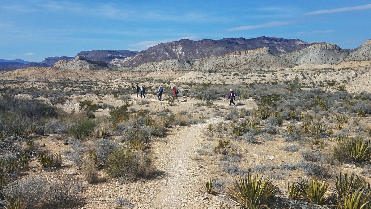
A few hikes
The pictures above were taken on hikes from West Contrabando trailhead, which is 6.5 miles west of the Barton Warnock visitor center on the east side of Lajitas. Fresno Creek passes just below and west of the trailhead. Here is the Fresno Canyon Area park map, PDF. There are a number of mercury mine ruins beside the trails, so the trails must be following old mine roads. One sign mentions a mine owner/operator dying of mercury poisoning. There are some large rusting bits of mining equipment near the trailhead, and what appears to be a filled-in mine shaft nearby. These are historical artifacts of environmental contamination that surely resulted.
Fresno Divide trail (park brochure, PDF) follows the east side of Fresno Creek a few miles and then cuts east to meet the trail shown in the first picture. The creek rises 15 miles north of the trailhead and flows south past flatirons on the west side of the Solitario, a big volcanic uplift. The latter needs serious attention by itself and will be covered in the second article about this park.
There is the East Contrabando trailhead, just east of Barton Warnock. Here is the Contrabando Multi-use Trail System brochure with map. This goes between the west and east trailheads, passes south of Contrabando Dome, and appears to be aimed at bikers. Between the trailheads it is 10 miles backcountry and 7.7 miles back on FM 170.
There are additional trails going further north from Contrabando Dome loop; the Fresno Canyon Area map looks interesting. I once had a scheme of backpacking a big loop northwest into the interior of the park from the east trailhead when I was younger, but realized water sources were questionable. If there were a problem likely no other hikers would happen by within a reasonable period.
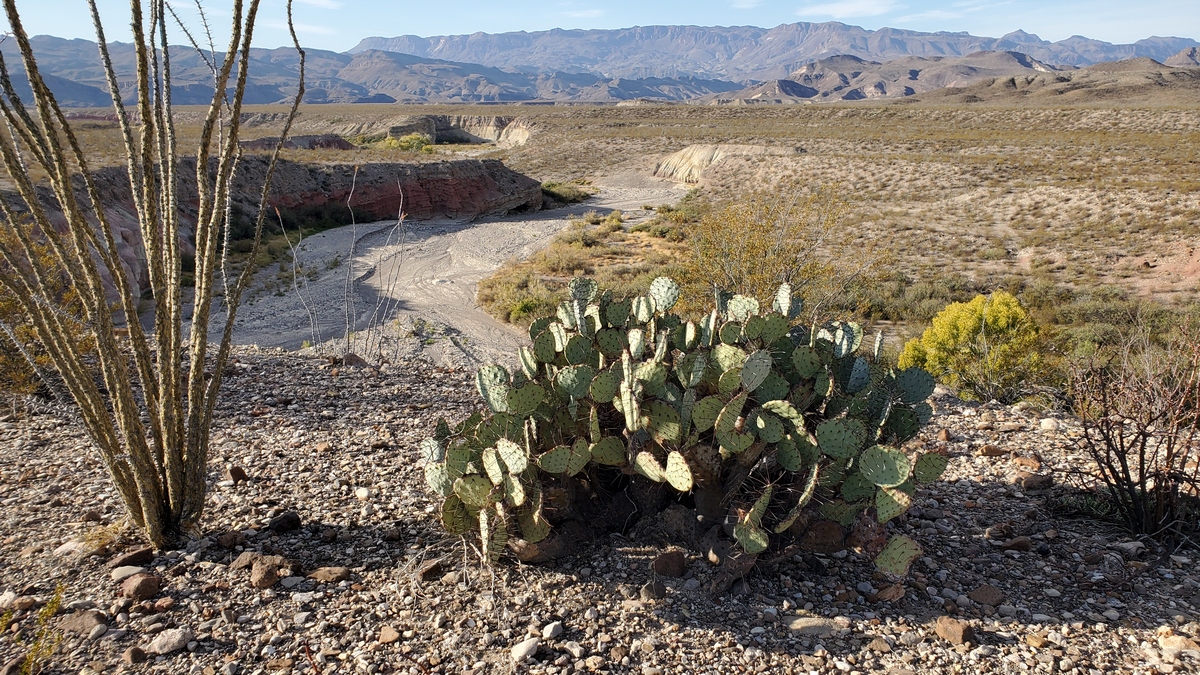
Rancherias loop and Rancherias Falls trail: these run north from FM 170. The loop is a nice three day backpack between the East and West Rancherias trailheads. The east trailhead is 20 miles from Barton Warnock and the west is 22.7. So if we don't have a shuttle that's a bit of a walk back to our car at the other trailhead. Water: there are springs on the east side at Casa Reza (above picture's caption) and another on the north side that flows seasonally down at Rancherias Falls.
From the west trailhead can also hike up Rancherias Falls trail. I hiked 11.8 miles RT on this February 2021; didn't bother going to the falls, which were dry. Did wander from the bottom of the trail over to the west side of the Rancherias loop to see a bit of that again, wasn't any further.
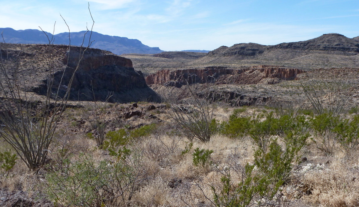
The next picture is from the Hoodoos trail; here is the park brochure (PDF). This is an easy 1.2 mile loop from the trailhead off FM 170 towards the Rio Grande, 26 miles west of Barton Warnock, and just west of Arenosa campground. The hoodoos, behind the viewpoint from which the picture was taken, are eroded columns of what looks like mudstone with caps of harder material.
And there is Closed Canyon. Here is the brochure. The trailhead is 22 miles west of Barton Warnock. This is 1.4 miles out/back, down the inviting slot canyon towards the Rio Grande as far as we can safely proceed. Beyond that we have to swim and have very sticky hands or a rope and buddies. My pictures weren't very good.
Invasive plants
Looking at the river side vegetation in the Hoodoos trail picture above I wondered what is the plant along the river. Then remembered at Grassy Banks campground there is a lot of a reedy plant likewise along the river, might better be named Reedy Banks. Could be giant reed; here is the page at TexasInvasives.org. Per a USFS page this was introduced in California from the Mediterranean in the early 1800s.
There is also salt cedar, aka tamarisk. Page at TexasInvasives.org. Said to have been introduced to the US in 1823 and was planted as an ornamental in the western US. By the 1920s was a serious problem. Likely bunch at this park but wasn't paying attention. Certainly have seen a lot in Utah.
Remains of another industrial operation
Havesting candelilla, picture above, for wax production was a big deal in west Texas by the early 20th century. There's an article on wax camps at TexasBeyondHistory.net and an NPS article about camps in what is now Big Bend National Park. On the Fresno Canyon Area map just north of the Fresno Divide trail there is noted “Wax Factory” and “ Buena Suerte Flotation Mill”. The Fresno Divide trail brochure mentions that the flotation mill was about candelilla processing, though the mill is just off the map in the brochure. See the hiking section above for the links to the map and brochure.
Primo campsite!
Good Texas Parks and Wildlife magazine web page Prime State Park Campsites. The photos are by Laurence Parent, an outdoors/travel writer who lives in Wimberly. Some of us have surely read his guidebooks. The pictures look very inviting. But I must say I would sacrifice bits of vistas for isolation and solitude.
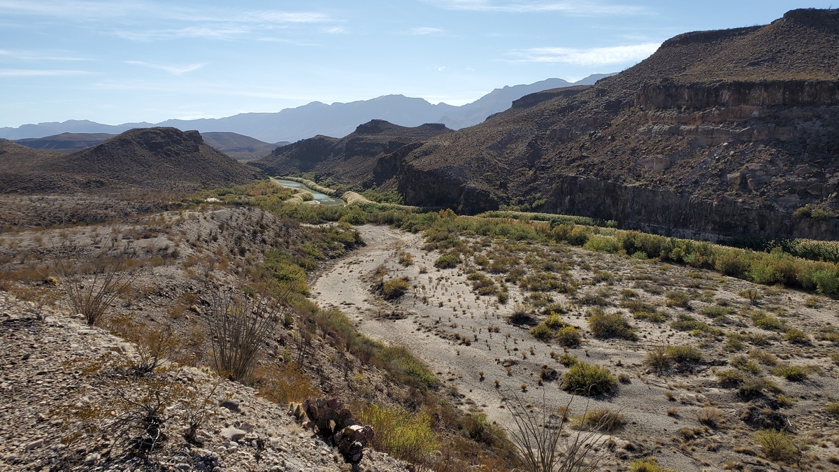
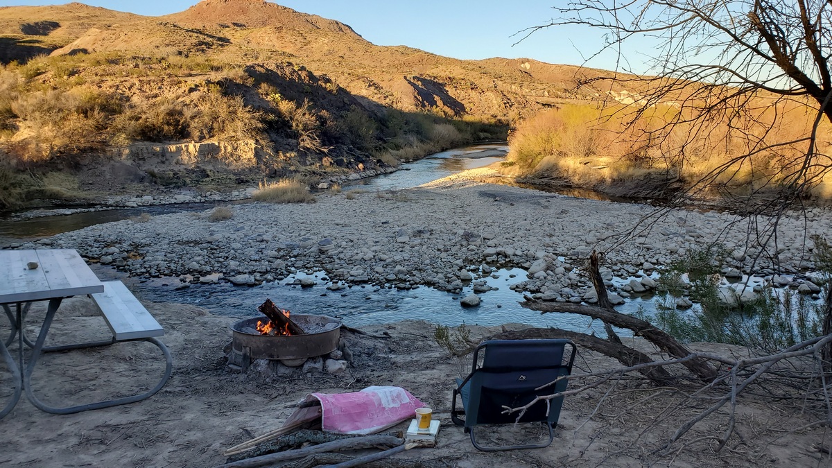
They seemed to have missed one in this park, personal opinion. Grassy Banks campground site #15, picture below. This is not just some puny Texas river like the San Antonio, Guadalupe or Pedernales. This is el Rio Grande! Though the river here is a shadow of it's former self in Colorado and New Mexico. This is the only site at the campground with a river view.
Stayed here again December 2021. The picnic table and fire ring have been moved up by the site's shade shelter, probably due to understanding that some of the bluff is due to collapse into the river anytime in the next few years. But this spot is still superb for the other activities in the picture. A stone fire circle remains.
The river had eroded the bank which is now overhanging a few feet in spots just below the fire ring in the picture. This erosion is happening as river channels move towards the outside of bends like the one here. Here is the Wikipedia page about point bars which explains why this happens. The river course what, fifty years?, ago was at the near side of the grassy area right. So Mexico has arguably picked up the rocky point bar center, but the opposite has occurred elsewhere along the river.
State Regulator's Email Contradict City Staff Claims Over Brackenridge River Wall
Statements of Texas Historical Commission staff released to Deceleration under a state Public Information Act request don’t jibe with repeated City claims that towering trees must be removed to fix the river wall.
Watch this video featuring recent statements by City staff related to the need to remove trees from Brackenridge.
Facts have been slippery things in the struggle over City plans to raze more than 105 trees in Brackenridge Park for a 2017 bond project intended to repair and restore a slew of historic features in the San Antonio River’s headwaters. Though rooted in a 2017 public vote, City staffers sprung an unexpected tree-clearing proposal on residents in January—billed as necessary for both repairing a portion of river wall (among other development goals) and helping drive out an established rookery of migratory birds.
In a quickly antagonistic confrontation with project critics, City staffers and regulatory partners with Texas Parks and Wildlife Department, for instance, repeatedly denied the project had any connection to a well-documented plan to force out an established rookery of migratory birds. Last month Deceleration published documents—including internal City emails and bond project language submitted by the City to San Antonio’s Historic and Design Review Committee—demonstrating the significant overlap of the two projects.
But in the fight to protect the birds and trees, it’s not only claims about the birds deserving public skepticism. Many of the repeated claims of City staffers intended to justify the removal of nearly 20 large trees to repair a section of river wall at the heart of the City’s plans—many classified as “heritage” trees and ranging from oaks to pecan to cypress—are also highly dubious.
In fact, a small trove of email communications generated by staffers at the Texas Historical Commission directly contradict numerous statements made by Jamaal Moreno, City of San Antonio landscape architect with the Public Works Department and a manager on the 2017 bond project. The documents were secured by Deceleration under a state Public Information Act request.
Moreno has repeatedly claimed, for instance, that modifications to the project that could save many of the trees were not only impractical but actually prohibited by state or federal regulatory agencies and direction provided to the City. His statements have been supported and amplified by others, including Parks and Recreation Assistant Manager Bill Pennell and Assistant City Manager David McCary on numerous occasions.
On January 26, while testifying for a favorable vote for tree removal from the San Antonio Planning Commission, Moreno said of the THC: “We asked them could we move [the river walls] forward or could we move them back to address some of the proximity issues with some of the large trees that we have. They considered it but basically told us, ‘No if you’re going to rebuild and rehabilitate these walls and these other structures they have to be rehabilitated in place.’ They have to be rehabilitated as close to original condition as possible.”
The statement was repeated in the project application itself, which read in part:
In addition, The Texas Historical Commission (THC) and the Office of Historic Preservation (OHP) have both weighed in on the importance of reconstructing and repairing all the cultural resources to their original condition and in their original location and configuration in order to preserve the historical significance of each particular cultural resource. For instance, in the case of the Lambert Beach walls and the Upper Labor Acequia walls, we would not be allowed to move walls forward or backward or adjust any configurations (i.e., lines, curves, angles, etc.) to avoid, or otherwise distance the walls from, any of the existing trees.
See the Brackenridge 2017 Bond Project Concept Drawings.
Though many residents turned out to the meeting to challenge the City’s narrative, Planning members in January approved the tree-removal request. From there, City staff still needed agreement from San Antonio’s Historic and Design Review Commission.
During a February 12 site tour, five days after THC’s Executive Director wrote the Public Works Department to say that the agency would not approve any tree removals based upon the information submitted to date, Moreno said that “we’ve got multiple governmental entities telling us that we cannot remove [the walls].”
Speaking before the Historic and Design Review Commission on February 16, at what could have been the last local hurdle to removing the trees, Moreno said that the Texas Historical Commission “indicated that something like this [moving the wall to protect the trees] would not be possible.”
Then, on a February 21 broadcast of Texas Public Radio’s ‘The Source,’ Moreno said that City staff are prevented by National Register of Historic Places protections over Brackenridge Park from modifying the wall. “When we’re rehabilitating them [historic structures], we can not adjust them or rehabilitate them to our liking. They typically have to be put in their original condition and in their original place.”
Slide show of some of the trees slated for removal
Full list and map of trees to be removed
However, based upon a review of dozens of internal THC email communications and at least one formal letter to the City of San Antonio’s Public Works Department, it appears that many of these statements are not accurate. In several messages relayed internally within the THC and one email shared with an employee of the SA Conservation Society Foundation, THC staff lamented what they described as Moreno’s mischaracterizations of the Commission’s position. More broadly, several emails complained that City staff was rushing through permits in San Antonio for the Sunken Gardens Theatre and the proposed tree removal at Lambert Beach while failing to first secure the necessary clearance from the THC.

“The THC is currently reviewing the City’s proposed tree removal project and has not made any determinations—formal or informal—pertaining to the proposed plans, including the fate of any heritage trees,” wrote Ashley Salie, the historic preservation project reviewer over Bexar County within THC’s Division of Architecture, in one of dozens of emails and related documents released to Deceleration under a state public-information request.
“I personally have not make any claims about tree removal or retention to Mr. Moreno, and I am unaware of my predecessor, or any of my other THC colleagues, making similar statements regarding heritage trees,” Salie wrote.
In this case she was responding in this case to a query from Beth Standifird, staff librarian for the San Antonio Conservation Society Foundation.
Bess Graham, director of the THC’s Division of Architecture, reviewed Salie’s email, responding: “Thanks, Ashley. Good response to Ms. Standifird.” Graham then suggested that Salie reach out to Moreno directly to discuss what the team believed were mischaracterizations of fact.
“Regardless of what they claim in the press,” Graham wrote, “we will proceed with the Antiquities Permit review.”
Here’s another similar statement from the bunch:

After the City’s plans to remove the trees came to light in January, a growing number of residents publicly challenged the City’s logic. City staff, including Moreno, rejected all calls from the community to reimagine the project to save the largest heritage trees slated for destruction.
Moreno and Pennell asserted regularly, with the support of Assistant City Manager David McCary and others, that modifying or moving the river wall in a way that may save the trees was a non-starter. They insinuated on multiple occasions that regulators at the the US Army Corps of Engineers and the THC have specifically prohibited such actions.
“The US Army Corps is no joke,” McCary told members of the HDRC in a hard press for an affirmative vote. The majority of HDRC members, much like the director of the THC back in February, we are now learning, opposed the tree proposal due to the City’s failure to prepare and submit a project plan. In spite of the fact the tree-removal proposal has received consideration by local community committees, the actual project the tree clearing is intended to serve has yet to develop beyond vague concept drawings highlighting the “story of water” in the City.
At the time that McCary was talking up his team’s transparency and the very serious nature of the US Army Corps, additionally, the feds had long since advised the City that the Army Corps was not stepping in on the matter of the trees. In an email to THC staff released as part of Deceleration’s record request, USACE Fort Worth District’s archeologist and project manager James Barrera wrote:
“The January 20, 2022, site visit was in large part to help USACE determine if we would have a federal action for the proposed tree removal activities and after discussions with all the City of San Antonio staff (and review of the design/plans) we determined that no discharge into waters would occur as a result of the tree removal activities,” Barrera wrote to THC staffers. “So no USACE permit would be required to complete these activities.”

The USACE, in other words, would likely be overseeing future construction work at the site, if it advanced, but were not stepping on on the tree removal plans.
Formed in 1953, the Texas Historical Commission’s mission is to “protect and preserve the state’s historic and prehistoric resources for the use, education, enjoyment, and economic benefit of present and future generations.” It has regulatory oversight under the National Preservation Act when projects impacting historical sites have federal involvement. Section 106 of the NHPA will likely be triggered in the drive to renovate Sunken Gardens because of past federal investment, but likely not on the Brackenridge tree removal, according to internal THC communications.
COSA’s dependence on the THC is due to Brackenridge Park’s listing in the National Register of Historic Places and designation as a State Antiquities Landmark. That landmark designation triggers THC review for any proposed work beyond what can be classified as “routine maintenance.”
In preparing on February meeting with City staff on the project, Salie wrote she was expecting “pushback” from City staffers since “not everyone involved in the project is a preservationist.” It was also clear that the authority of the agency to assert protections for the trees may be challenged, she wrote at the time. “It’s possible some of the preservationists will ask if the trees are truly in our purview as they are not part of the built environment per se; however, the landscape is a signifiant aspect of the park and is emphasized in the NR [National Register] listing,” Salie wrote.
A week later, on February 18, Salie wrote to one of her team’s media liaisons about what she saw as the mischaracterization of regulatory positions on the proposed mass tree removal:
“I wanted to add one more note of clarification as a follow up to our conversation this morning. COSA has been quoted as stating (in so many words) that the THC and USACE have said the raceway walls at the Lambert Beach area of Brackenridge Park need to remain, and therefore the adjacent trees must go. Again, to my knowledge, no one from THC or USACE has made any such comment. Beyond that, THC has not reviewed or approved the tree removal project as a whole, which I know we discussed in-depth this morning.”
Paul Berry, a spokesperson for the Public Works department, said that Moreno “stands by his previous comments.” He added that no one from THC had at any time reached out in an attempt to correct Moreno either. Staff at THC were not available for comment on Friday. But the difference between the public statements of City staff and the private emails of state regulators couldn’t be more stark.
Days after the Planning Commission approved the City’s request to take out the trees, Salie wrote Graham, director of the THC’s Division of Architecture, and a fellow THC program coordinator.
“Jamaal Moreno with the city, who was present at the Brackenridge meeting I attended on January 20, is quoted in this article saying something to the effect that the THC won’t let heritage trees remain in the Lambert Beach area because they are damaging the cultural resources (historic walls and other above-ground structures). There has not been a formal review by the THC on this project giving any sort of indication like this. I also did not say anything that would give that impression during the site visit on January 20.
“Based on this article, and the fact that COSA is presenting the project in front of the HDRC,” she continued, “I am sensing either a misunderstanding of state review protocol on COSA’s end, or a misunderstanding of city review protocol on my end. Something does not seem to be adding up to me.”
Days later, Salie wrote to a member of THC’s communications team: “THC has not completed its formal State Antiquities Landmark and Section 106 review of the project, so there is a disconnect between COSA and THC as far as the project’s approval status and overall progress.”
Although approved by voters in 2017, City staff did not ramp up on the bond project until January of this year. The request for tree removal—paired with a preexisting campaign to forcefully evict an established rookery of migratory birds—caught the attention of many community members and sparked a surge in grassroots resistance. That seemed to crest at February’s HDRC hearing with two hours of public testimony almost universally opposing the project. Now with a new City bond vote approaching in May, again with Brackenridge funding on the line, and birds returning to their roost, staff were advancing with full urgency.
They just weren’t advancing fully prepared. And it showed.
The City advanced its tree-removal agenda without a plan for local commissions to review and without a complete permit application on file with the THC. While Deceleration first reported the lack of a permit application at the state weeks ago, these new emails show the City was rushing for approvals based on partial maps with promises of revisions to come.
On January 13, for instance, Jennifer DiCocco of COSA’s Public Works department filed what she called an “interim plan set” for the proposed tree removal with the THC, saying that staff were still actively mapping trees and further changes would be coming. Yet even as she submitted inadequate paperwork she also alerted the regulatory agency that the City planned to start the tree removals two weeks later.
“Changes could be to which trees are going to be removed or which ones require monitoring of aboveground resources and to the notes provided in the plans—both current in the set and ones to be added,” DiCocco wrote. “A final and complete set will be provided to both the THC and USACE as soon as possible after today, but before the work is planned to begin on 1/26/2022.”
Emily Dylia, the archeologist with the THC on the receiving end of that email, did not seem impressed.
“We understand and appreciate the tight timeline on this project,” Dylia replied. “As such, we will do our best to provide a timely response. However, I do want to point out that the THC has a 30-day review period, and at best you are asking us to review in half of that time.”
In a letter on behalf of THC Director Mark Wolf sent almost a month later, Salie reminded Miranda Garrison, project manager at San Antonio’s Public Works Department, that THC still did not have a suitable application from the City. “The review staff is unable to complete a formal SAL [State Antiquities Landmark] permit review at this time due to inconsistent and insufficient documentation provided in the application materials,” she wrote.
In detailing COSA’s faulty work, Salie continued:
“THC will not approve demolition of a tree within an SAL without first reviewing evidence that clearly demonstrates why the tree negatively affects another historic resource, nor will it approve demolition of trees for the purpose of accommodating and implementing the new construction of an unapproved design. Sufficient documentation for demolition rationale includes approved plans, photographs, and narratives.”
Read the full letter from Ashley Salie
A week after HDRC granted the City a week to develop a plan to submit for consideration, San Antonio City Manager Erik Walsh announced on February 22 that the project would be pushed into 2023, ostensibly to allow for more public dialogue.
Based upon the materials from the THC, however, it now appears the delay was not only a recognition of rising community protest. The THC communications show the City’s hand being forced by state regulators who refused to act on faulty, incomplete, or nonexistent development plans.
“No one wants to remove heritage trees, especially from a historic City park,” Walsh was quoted in the City’s press release, “but if the removal ultimately remains necessary to protect the public and historic structures at Brackenridge, I want the community to understand the full context of the project.
“I have directed staff to pause consideration by the HDRC, which has dominated the conversation and distracted from the broader benefits of the restoration work, while we complete the design and work with our partners and stakeholders.”
With that HDRC ‘distraction’ out of the way, the City is preparing to sell their vision afresh at the first of three public hearings scheduled for March 22 at the Witte Museum.
by Greg Harman, Independent Journalist and publisher of "Deceleration"
Outings: The Call of the Wild
Visit the Alamo Sierra Club Outings page on Meetup for detailed information about all of our upcoming Sierra Club Outings.
The Alamo Sierran Newsletter
Richard Alles, Editor
Published by the Alamo Group of the Sierra Club, P.O. Box 6443, San Antonio, TX 78209, AlamoSierraClub.org.
The Alamo Group is one of 13 regional groups within the Lone Star Chapter of the Sierra Club.
Changed your contact information?
If you're not sure whether the Sierra Club has your current email address, send an email to Member Services with your name and address and/or member ID (see Locating Your Member ID) so they can add your email address to your member record.
Have you moved? Let us know by sending your old address, your new address and your member ID to: address.changes@sierraclub.org.
Go online for the latest news and events
 |