In Memory of an Alamo Group Leader
We lost one of our early leaders in the Alamo Group with the passing of Helen (Kiss) Telfer on February 10, 2022. Helen was born in 1931 in a log cabin without running water near the town of Crystal Springs, Mississippi.
She graduated from Berea College in Kentucky with a BA degree in history in 1957, making pottery and tapestries to help pay for her education. Helen later contributed her pottery to fundraisers for the Alamo Group. In 1959, she obtained her Master of Arts degree from Southern Illinois University.
Helen joined the Alamo Group in the early 1970's after moving as a widow of Arnold Kiss to San Antonio with her daughters Mary and Beth. She had obtained a teaching certificate to help support her family.
As a 4th grade school teacher, Helen was off every summer. Helen was the membership chair for the Alamo Group for many years.
The following is a quote from her daughter Mary:
I remember her typing mailing labels and member lists late into the night. I also remember attending several meetings where slide shows featuring various club outings opened my eyes to the big beautiful world in which we all live. Helen led annual trips to Lost Maples in November and helped to put together an outing to Lost Maples before the park was opened to the public where volunteers helped to clear trails. That trip was a lot of work and I remember it was not as fun!!!
Helen used to wear a shirt that said, “The mountains are calling, and I must go.” According to Mary:
Helen felt that the Sierra Club helped raise her two girls. Being widowed, mom felt it was important we were exposed to camping and being part of the Sierra Club group environment. It enabled Helen to expose her children to events and challenges we otherwise wouldn’t have experienced. It all felt so natural to us; i.e., for a widow to pack up two young girls and head off for adventure. Big Bend and Zion National Forest were both big hits with our family.by Jerry Morrisey, former Alamo Group Outings leader
A Whirlwind Journey of New Findings in the Solar System
Our June general meeting features Danielle Wyrick, Ph.D, from the Space Science and Engineering Division of Southwest Research Institute, discussing the latest developments in the science of our solar system.
Tuesday, June 21st
6:00 p.m.
Online via Zoom
Meeting schedule
Zoom link opens at 5:30. Please join early to ensure you are admitted prior to the start of the featured program.
| Informal get-to-know-you | 6:00 pm to 6:15 pm |
| Announcements | 6:15 pm to 6:30 pm |
| Featured program | 6:30 pm to 8:00 pm |
RSVP
To receive an email with the information you need to join the Zoom meeting, visit our event page and submit the RSVP form.
Program topic
With all that is happening in the world, it can sometimes be easy to forget that our planet is part of a vast solar system. Come for a whirlwind tour of the solar system with Dr. Wyrick, and catch up on the current state of the science, how we have been able to explore our near and more distant planetary neighbors, the habitability of these worlds, and where we are headed next.
About our speaker
Dr. Danelle Wyrick is a planetary geologist with a background in structural geology, volcanic-tectonic interactions, and fluid/gas migration through fractured systems. Her research includes analyses of the origins of geologic and tectonic features and processes, including faulting and tectonics on Mars, Ganymede, our own moon, and other smaller planetary bodies such as Eros and Vesta.
She currently serves as a Science Co-Investigator on NASA’s Lunar Reconnaissance Orbiter and Europa Clipper missions. For a nice introduction to Dr. Wyrick and her work, visit the August 2021 episode of Think Science | Spirit & Opportunity: New Frontiers in Space Exploration.
The Alamo Group of the Sierra Club holds its general meetings the 3rd Tuesday of most months. They're always free and open to the public.
The Other Side of Nowhere: Big Bend Ranch State Park — More Stuff In the Interior
This article, set in Texas' largest state park, is largely about hikes and vistas in the interior of the park off Main Park road.
This is further to basic info about this park in the April 2022 issue, which covered hikes and campgrounds along FM 170, just north of the Rio Grande. In addition, article in May 2022 covered some other spots in the interior of the park, particularly near the Solitario. Here's the link to the park maps page; the Discovery Map is the big overview. The Other Side of Nowhere is explained in the May 2022 article.
Visiting the interior
It is a 27 mile drive east from Presidio along Casa Piedra and Main Park roads to the Sauceda visitor center near the center of the park, which has showers and a bunkhouse. Just east of Sauceda is South Leyva campground; a bunch of sites with shade shelters, fire rings and a composting toilet.
And there are a bunch of widely distributed primitive campsites in the interior of the park, many accessible only by 4WD roads; for these we are supposed to bring our own toilet. There is a really excellent park guide for the primitive vehicle accessible sites assembled by a park volunteer; good photos for each site.
It is quite excellent to stay a spell at South Leyva and do short drives west and east to trailheads. But note that, in the event of a problem, traffic in the interior of the park, even along Main Park road, is very limited. Some campsites may not see visitors for months or longer.
Hardly any cell phone service anywhere but there is wifi at Sauceda. Park rangers do drive Main Park road daily, at least to Sauceda.
It is important to be prepared for vehicle problems. On prior trips I had no problems though was not very well prepared.
On a trip December 2021 I was well prepared happily, as I had a flat tire and saw another camper did also. Highly advised: full size spare wheel, tire inflator, tire plug kit, tools, jump starter, jumper cables, multimeter, tow strap, fire extinguisher, shovel etc. Ask others if they need help with a problem; could be us next time.
Just a few hikes
How to plan hikes such as the ones below: first search for web pages about “Big Bend Ranch state park best hikes”. Correlate with the park maps; the most popular ones have park brochures.
Second: look at the Discovery map for trails near stuff that might be of interest, particularly loop routes. Search for web pages about these also, using the canyon name or such.
Third: prioritize and construct a sequence to minimize driving. Might wish to change campsites. After spending many hours at this we have a list of hikes that will take more than one trip. Then on the trip we make some changes and have more ideas; then have trips in our heads for years to come, just for this one park.
Horsetrap trail is a nice hike that I didn't include a picture from below, don't want to overdo. This is an easy 4.5 mile loop from Sauceda. Here is the trail brochure.
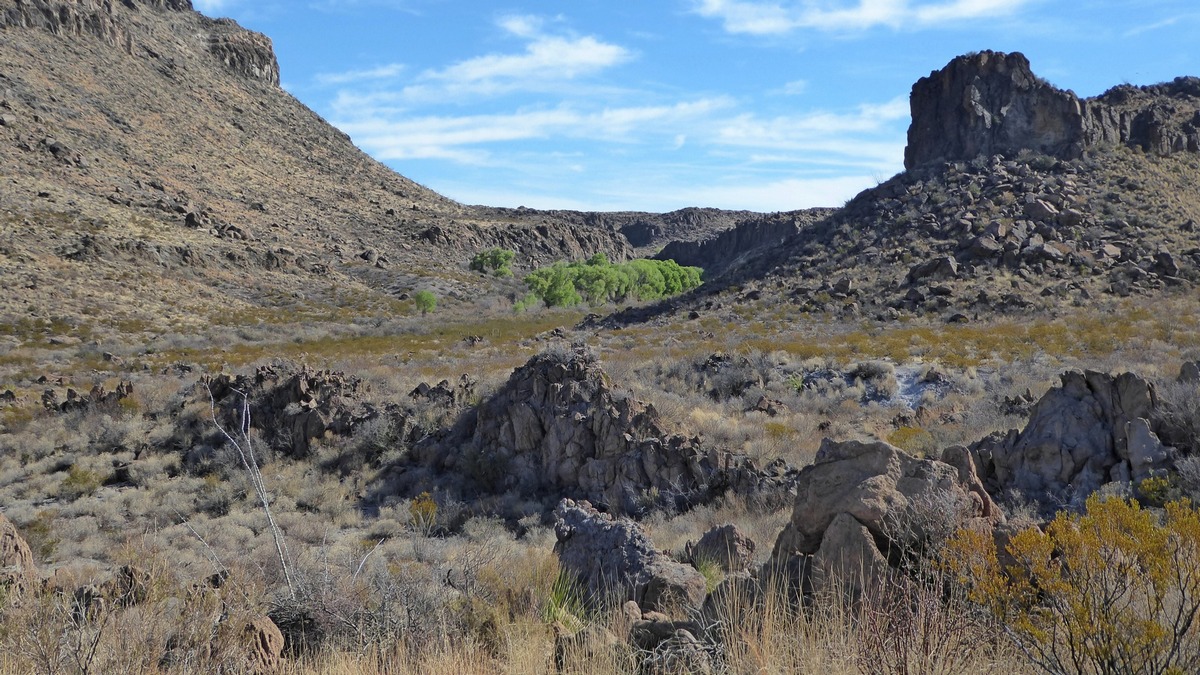
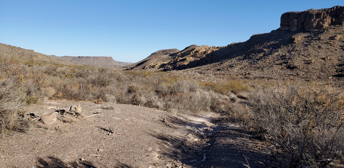
The first picture was taken near the trailhead for Ojito Adentro (translation: small spring within), looking north. The trailhead is 8.2 miles west of Sauceda on Main Park road. Here is the trail brochure.
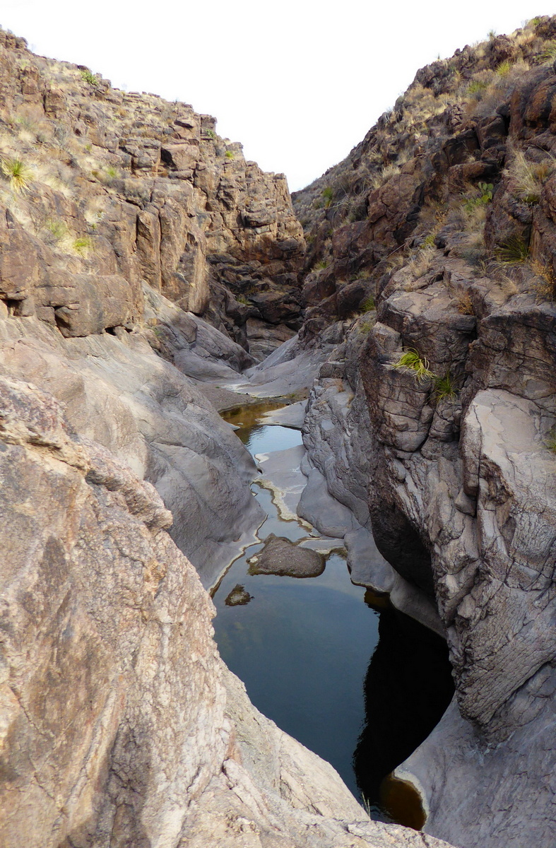
The next two pictures are about Cinco Tinajas (translation: five pools) and two loops north of that spot. The trailhead is 1.5 miles west of Sauceda on Main Park road. Here is the trail brochure.
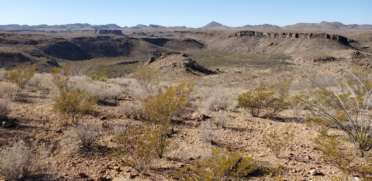
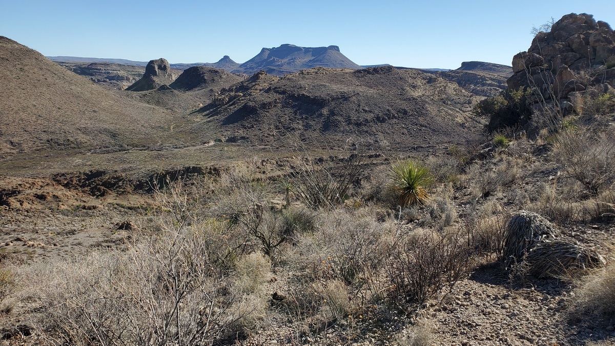
The next picture is from the Rancho Viejo trail. The turnoff for this is 13.6 miles west of Sauceda on Main Park road.
Then it is less than 1 mile in to the trailhead, which is just past Rancho Viejo campsite. There is an operating windmill near the campsite, and the water is accessible but must be sanitized. The campsite would be a bit noisy due to the windmill.
This trail is an out-and-back; I did 6.7 miles round trip to Papalote Alto (slang, high windmill), which is on the map. Another pleasant meander across the Chihuahuan Desert.
I had the bright idea could make a loop of it, turning south on a mapped route of some sort near Papalote Alto, then working back to the trailhead along Palo Amarillo Creek, also on the map. Should be doable, right? Decided not to upon seeing the serious canyon containing the creek near the trailhead.
Also on the map we can see the trail continues east from Papalote Alto a few miles to a fork. Here one branch goes to the Yedra trailhead (following two pictures), and the other south to Main Park road.
Sunshine and lollipop loops
Next two pictures are from a lollipop loop route up Yedra Canyon, 10.8 miles round trip from Yedra 1 campsite. Looked questionable to drive to Yedra 2, and only an extra mile or so each way. Turnoff is 4.8 miles west of Sauceda on Main Park road. Driving to the actual trailhead would have been even worse I realized once I saw the road condition.
This is an example of a nice route about which I couldn't find any web pages. Looking at the Discovery map we can see Yedra Canyon northwest of Cinco Tinajas, with a couple loop routes noted. Such notations on the maps are often traces of old ranch roads that are now occasionally used by hikers and bicyclists. So gave this one a try; very nice.
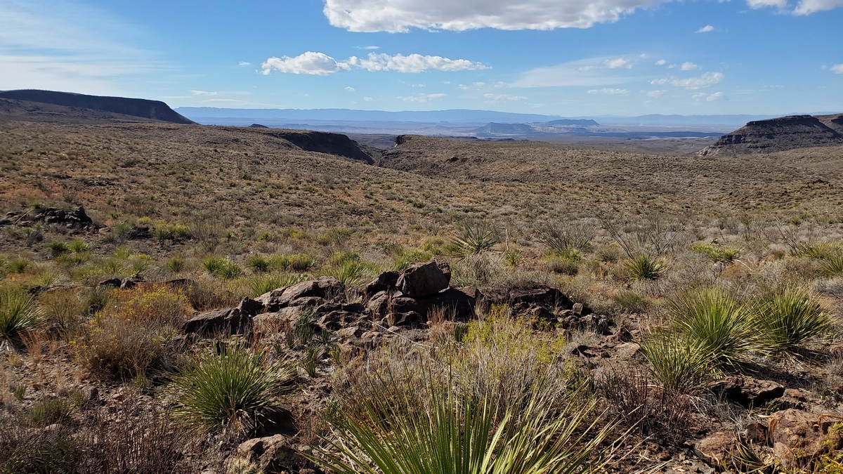
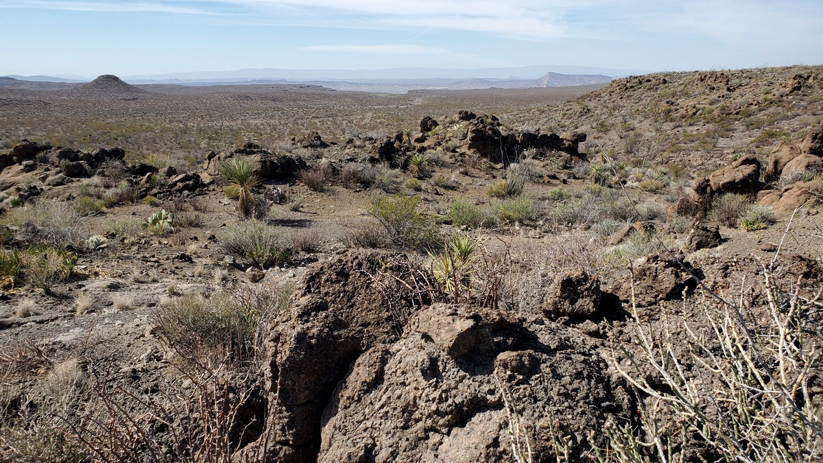
The last picture is from the Palo Amarillo trail. The turnoff from Main Park road is 14.5 miles west of Sauceda. We can look at the area map, Bofecillos Highlands/Cienega and Alamito Lowlands.
I didn't look closely before doing the hike, so didn't identify the drainage that is Palo Amarillo Creek nor the spot marked as a spring at the end of the trail. Likely dry anyway. This drainage starts south of Papalote Alto and the Rancho Viejo trail, mentioned regards the fourth picture. Runs to the Rio Grande about four miles southwest of the spring site.
The Vista de Bofecillos campsite is near the trailhead for this trail. What's this about? Looking at the map a year after doing the hike I see Bofecillos Creek and canyon to the south. And Bofecillos Peak is four miles southeast, elevation 5002'.
The Bofecillos Mountains are six miles southeast, including the highest elevation in the park, Oso Mountain, 5137'. So can we climb Oso? Found a web page, sounded ok, with access via Oso Loop road. But the east end of this road, how I planned to get in, may not have been graded since no telling when. Decided not to, but could have gone in the west end which looked good, and there is a supposed route to the peak on the map. Couple more hike ideas for a future trip.
Outings: The Call of the Wild
Visit the Alamo Sierra Club Outings page on Meetup for detailed information about all of our upcoming Sierra Club Outings.
The Alamo Sierran Newsletter
Richard Alles, Editor
Published by the Alamo Group of the Sierra Club, P.O. Box 6443, San Antonio, TX 78209, AlamoSierraClub.org.
The Alamo Group is one of 13 regional groups within the Lone Star Chapter of the Sierra Club.
Changed your contact information?
If you're not sure whether the Sierra Club has your current email address, send an email to Member Services with your name and address and/or member ID (see Locating Your Member ID) so they can add your email address to your member record.
Have you moved? Let us know by sending your old address, your new address and your member ID to: address.changes@sierraclub.org.
Go online for the latest news and events
 |