Q&A: CPS Energy CEO Rudy Garza on 'The People's Right to Energy'
CPS Energy is a utility in transition. Internal commitments and culture, global market and climate forces, and sustained community pressure have all pressed the nation’s largest City-owned provider of electricity and natural gas into the shape it holds today.
While electricity is generated primarily from a mix of coal, gas, and nuclear power, CPS bought deeply and early into wind power and is building out solar again this year after a years-long slowdown. Through its branded FlexPower Bundle effort launched in 2020, CPS announced its plan to bring online 900 megawatts (MW) of additional solar, 500MW of “firming capacity” (originally billed as “gas” but modified to allow for the possible entry of more renewables at the request of San Antonio Mayor Ron Nirenberg an ex officio CPS board member), and 50MW of energy storage. (Read the original Request for Proposals here.)
The first tranche of 300MW of solar was announced last week. CPS Energy is also the operator of one of the nation’s youngest coal plants: The two-unit Spruce plant is the region’s largest climate offender. With a pressing need to close the coal plant, thousands of megawatts of old gas units aging out, and explosive growth in the housing sector (as well as heavy energy users like data centers accumulating and crypto miners crashing into Texas) the utility’s leadership is looking closely at cleaner power sources—like geothermal—and evolving storage technologies, such as compressed air. (You can see a short video on emerging tech under discussion on Decel’s Twitter here.)
Editor's note: On June 16th, City Council voted 7-3 to approve a 5-year extension of the STEP energy efficiency program. Read the rest of this story on Deceleration.
by Greg Harman, founder and co-editor of DecelerationSan Antonio Water System’s Proposed Rate Structure
Our July general meeting features Joe Yakubik (SAWS Rate Advisory Committee Member 2019/2022), discussing SAWS's proposed new water rates in the context of affordability for low-income residents, climate change, population growth and the critical need for conservation.
Tuesday, July 19th
6:00 p.m.
Online via Zoom
Meeting schedule
Zoom link opens at 5:30. Please join early to ensure you are admitted prior to the start of the featured program.
| Informal get-to-know-you | 6:00 pm to 6:15 pm |
| Announcements | 6:15 pm to 6:30 pm |
| Featured program | 6:30 pm to 8:00 pm |
RSVP
To receive an email with the information you need to join the Zoom meeting, visit our event page and submit the RSVP form.
Program topic
As south-central Texas endures a record hot summer, combined with a prolonged drought, coupled with booming population growth, the San Antonio Water System is proposing a new rate structure to determine who pays how much for water. Affordability and Conservation were the top-two ranked objectives for the Rate Advisory Committee (RAC), with Drought Management ranked seventh of the eight emphasis areas.
Revenue Stability was a primary concern for the SAWS staff, with potential reductions in water sales in average-to-wet years seen as a risk to the economic viability of the utility. The water rate structure depends on the type of water service received.
So far, the RAC has recommended few changes to the General Class structure (i.e. businesses), where customers’ rates are based on prior-year use and not the volume currently sold. Rates for the direct sales Recycled Class are proposed to increase over the next five years; currently this program is subsidized by approximately 66%.
Residential rates are a complex combination of meter size (“service availability charge”), usage volume, and other factors. The proposed structure must be approved by the SAWS Board, and then approved by City Council prior to taking effect. SAWS will engage with the community about the changes in the upcoming months. The SAWS rate structure affects us all, today and tomorow. Come and learn.
About our speaker
Joe Yakubik was the District 9 representative to the SAWS RAC in 2019 and in 2022, serving as the Vice Chair in 2019. He has also represented District 9 as part of the CPS Energy Citizens Advisory Committee.
His interest in water and rates was borne out of concern about the accuracy and clarity of public information from the local utility. When it rains, he uses captured rainwater to irrigate the pollinator habitat in his San Antonio yard.
The Alamo Group of the Sierra Club holds its general meetings the 3rd Tuesday of most months. They're always free and open to the public.
Organ Pipe Cactus National Monument & Was It Worth It? A Wilderness Warrior's Long Trip Home
Organ Pipe is on the border southwest of Tucson, Arizona. Here is the NPS web page and from there the map page. An article in this newsletter March 2016 (PDF) contains some basic info about visiting.
This is in the Sonoran Desert, as compared to the Chihuahuan Desert in the Big Bend region of Texas. Here's the Wikipedia page about the desert.
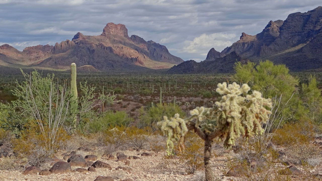
On my hike into the Bates Mountains, picture above, I was tracked down by couple Border Patrol guys in a truck. They smiled and said “we followed your boot prints; don't see many of you here!” Meaning a white guy with hiking gear, instead of someone with brown skin, worn-out clothing and a nearly empty water jug.
On other hikes I saw some water and food caches I believe left by No Mas Muertes (No More Deaths), a humanitarian aid organization based in Tucson. I'll be sending them another donation.
Quitobaquito Springs and the Wall, dammit
These springs likely come from the Quitobaquito Hills to the northwest, or the Cipriano Hills further north. These fill the pond in the picture below, which is called Quitobaquito, just north of the border, in the southwest section of the monument.
Here's the park page, which was last updated June 2018. But there are park alerts about closure April-May 2022 for pond restoration; hopefully we'll be hearing how that went. This was one of only two bits of standing water I saw in the entire monument. Extremely important for wildlife.
I read in a National Geographic article that by July 2020 the flow rate of the springs had dropped by about 60% from the average in 2008 (chart in the article). Likely due to wells drilled for wall construction. The pond may have went dry and a lot of animals died. Supposedly wells weren't drilled within five miles of the pond, but the hydrology of the area is poorly understood. An earlier section of border wall used 700,000 gals water per mile; but the new wall is twice as high.
If Edward Abbey (see the last section) were still around he surely would write a book about sabotaging wall construction equipment starring George Washington Hayduke. We miss Ed.
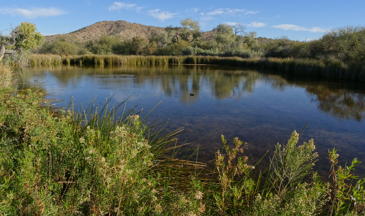
We've read about the impact of the wall on wildlife migration. Quitobaquito is the only water within many miles at least on the US side, and the wall is just to the south. So most wildlife to the south can't get to the water anymore even if the pond is restored. Even ground-dwelling birds are inhibited.
I was in particular thinking about migrating jaguars being stuck behind the wall, having heard they had been spotted in Arizona. Found this article: The Controversial Plan To Bring Jaguars Back To the US. Seems the sightings were in the Chiricahua Mountains to the east of Tucson, not near Organ Pipe.
In the article there is a picture taken in the Tohono O’odham reservation just to the east of Organ Pipe. That tribe participated in the re-introduction plan but their reservation is just west of the planning area.
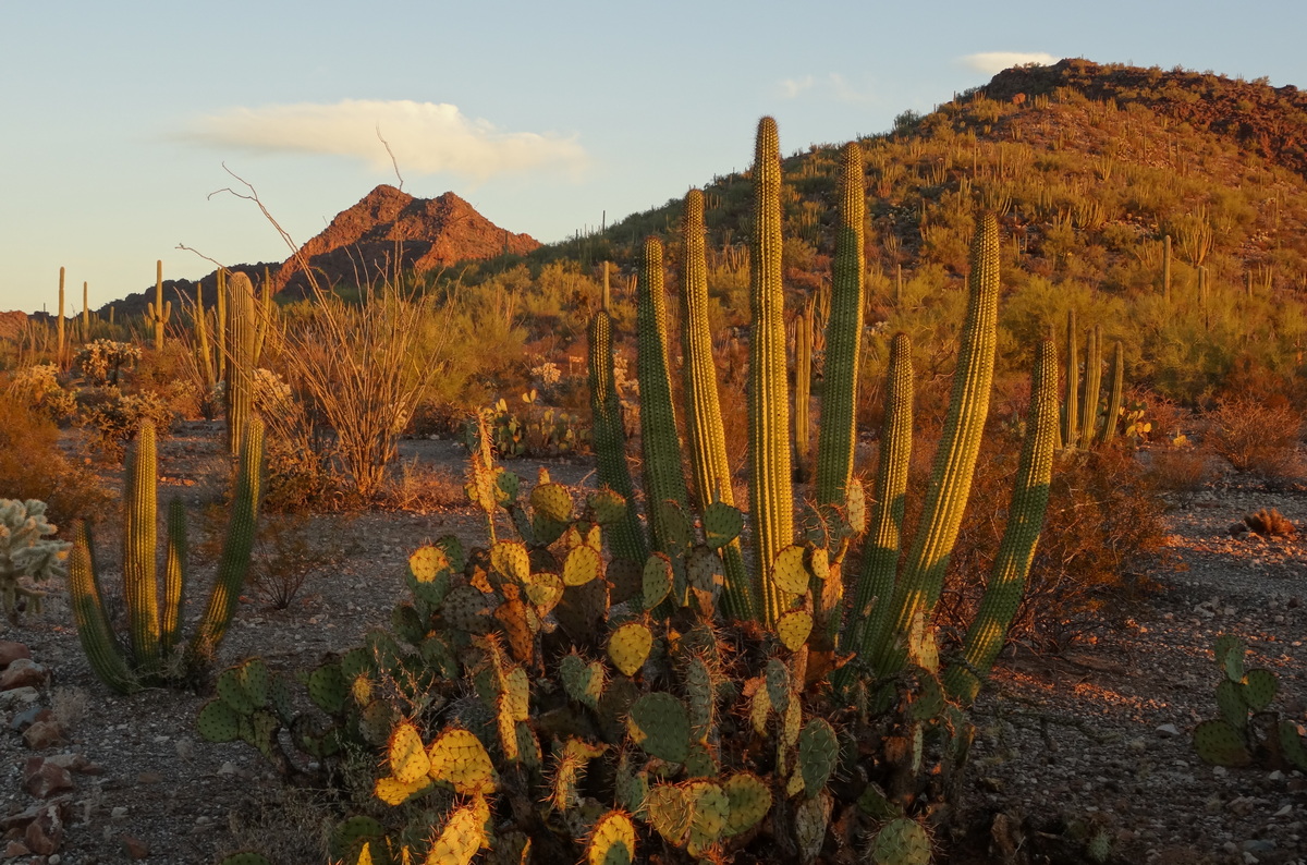
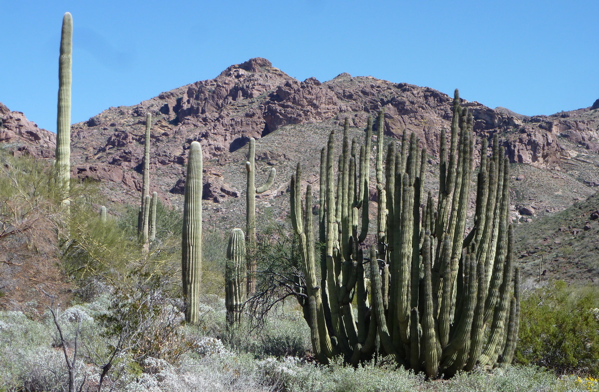
The range of organ pipe and senita cacti
Organ pipe cactus, next picture, is common in the national monument but rare outside of that. Wikipedia page. Senita cacti are even more rare; here's a page on those. Second picture below. The latter look a lot like organ pipe but have woolly masses of spines at the tops of the branches. I guess I drove in from South Puerto Blanco Drive to do the Senita Basin hike and get the 2nd picture below.
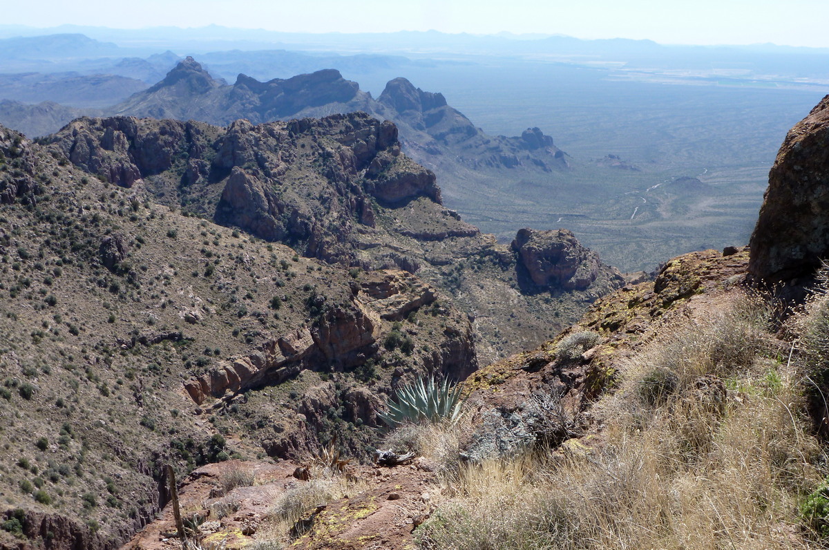
South Puerto Blanco and North Puerto Blanco drives comprise a super loop (see the map) with a bunch of good hikes and great vistas.
Was It Worth It? A Wilderness Warrior's Long Trip Home
That is the title of a book by Doug Peacock, published 2022. In the book he travels a bunch of places with other wilderness protectors/advocates/authors including Jim Harrison, Terry Tempest Williams and Rick Bass. And also Yvon Chouinard, founder of the outdoor equipment and clothing company Patagonia. The book publisher is Patagonia. His writing style is appealing and often self-diminishing as he talks about his ignorance and mistakes.
Peacock was a Green Beret medic in Vietnam, and later dealt with PTSD by photographing grizzly bears, covered in his first book, Grizzly Years. He would camp in the nastiest brushy spots as the bears would avoid those. Here's his webpage.
Peacock was the inspiration for Edward Abbey's George Washington Hayduke character in the books Monkey Wrench Gang and Hayduke Lives! He and three friends illegally buried Abbey un-embalmed on public land in southwestern Arizona as he had wished. Based upon hints the spot is likely in the northeastern section of Cabeza Prieta National Wildlife Refuge, just north and west of Organ Pipe, or in the western bit of Organ Pipe.
He mentions Growler Wash, which drains from the Growler Mountains in Cabeza Prieta into Organ Pipe, in connection with visiting Abbey's grave. He knows a lot about this area; mentions traversing Cabeza Prieta ten times, distances up to 165 miles, with pack weights up to 95 lbs including 3.5 gallons of water.
In the book's last chapter he is re-visiting an area in Shiwassee Flats National Wildlife Refuge, in Saginaw County, Michigan, that he frequented as a child and collected a bunch of Native American artifacts. On the trip back he is burying the artifacts where he found them, a bit of outlaw repatriation as he describes it. With bunch of profound background commentary.
In the postscript he talks about the impact of climate change: "When it is indeed out time to walk offstage with the mammoths, what might be the measure of our character at the end of our tour? After peering into the abyss, how do we behave? There is great joy in doing the toil of the world, fighting for wild causes, saving pieces of the magnificent natural world. There's plenty of work; do your job with decency and an open heart. Love your brothers and sisters in all actions, in all relationships. Speak the truth. Extend your innate empathy to distant tribes and strange animals. Arm yourself with friendship and love the Earth."
Now I wish I had visited Cabeza Prieta when I was at Organ Pipe in 2015. I was already halfway there at Bates Well, the trailhead for the route into the Bates Mountains (1st picture). It is said to be a reasonable AWD drive up into the Growler Mountains on Charlie Bell road, west of Bates Well. Here's a page about the refuge at AmericanSouthwest.net. The road at least to Bates Well was pretty washboarded when I visited, I presume due to Border Patrol traffic.
Peacock also wrote Walking It Off, which includes bits about his friendship with Abbey. And helping him during his last days. I must read this again.
by Kevin Hartley, Alamo Group Outings leaderMovie Review: Deep in the Heart
I got a chance to see the movie “Deep in the Heart” yesterday and enjoyed it. With at times stunning photography, it documents various animal species in different ecosystems of Texas. If you like nature photography, you’ll like this movie.
It is playing some local theaters now and is likely to be on streaming platforms later in the year. I attended a special showing in Austin last night, and the movie director Ben Masters said they had to wait three hours for a blind catfish that lives in the Edwards Aquifer to swim through a hole in a rock. They nicknamed the catfish Ray Charles.
The director was very excited about the daylight footage they got of a Texas ocelot in the wild with kittens. Check it out!
by Bill Barker, FAICP, FITE; Alamo Group Executive Committee member
Outings: The Call of the Wild
Visit the Alamo Sierra Club Outings page on Meetup for detailed information about all of our upcoming Sierra Club Outings.
The Alamo Sierran Newsletter
Richard Alles, Editor
Published by the Alamo Group of the Sierra Club, P.O. Box 6443, San Antonio, TX 78209, AlamoSierraClub.org.
The Alamo Group is one of 13 regional groups within the Lone Star Chapter of the Sierra Club.
Changed your contact information?
If you're not sure whether the Sierra Club has your current email address, send an email to Member Services with your name and address and/or member ID (see Locating Your Member ID) so they can add your email address to your member record.
Have you moved? Let us know by sending your old address, your new address and your member ID to: address.changes@sierraclub.org.
Go online for the latest news and events
 |