Like Science
Global warming is like nuclear weapons –
both threaten all life but we ignore them.
Meanwhile we watch Wimbledon.
Humans are like tyrannosaurus rex –
masterful, dominating predators
till our home-made asteroid strikes.
Earth is like other planets round our sun
except here water begets biosphere,
beauty begets consciousness.
Tomorrow can’t be like yesterday
nor like now. We must open our eyes
to save our home. When, and how?
Building a Clean Energy Future: CPS Energy, the Public Utility Commission, Climate Justice, and Building a Stronger Sierra Club
Our August general meeting features leaders from the Lone Star Chapter of the Sierra Club. Cyrus Reed (State Conservation Director) and Dave Cortez (State Chapter Director) will be discussing their work to fix the Texas grid with people-centered solutions and make CPS Energy more responsive to climate justice initiatives.
Tuesday, August 16th
6:00 p.m.
Online via Zoom
Meeting schedule
Zoom link opens at 5:30. Please join early to ensure you are admitted prior to the start of the featured program.
| Informal get-to-know-you | 6:00 pm to 6:15 pm |
| Announcements | 6:15 pm to 6:30 pm |
| Featured program | 6:30 pm to 8:00 pm |
RSVP
To receive an email with the information you need to join the Zoom meeting, visit our event page and submit the RSVP form.
Program topic
Texans are suffering multiple intersecting crises this summer. As we endure record heat and drought, our power grid remains vulnerable and our energy bills are skyrocketing.
Air pollution is on the rise and politicians across the state and in San Antonio seem less and less motivated to take strong action in response to the climate crisis. Join staff from the Sierra Club’s Lone Star Chapter as they initiate a discussion of ongoing work to press Governor Abbott and the Public Utility Commission to fix the grid with people-centered solutions, and hear updates on our support for community campaigns to make CPS Energy more responsive to climate justice initiatives.
There is no path to victory and change without broad based organizing and bringing in more voices. Come learn about how you can plug in and be part of a unique opportunity to organize for energy democracy in San Antonio and across Texas.
About our speakers
Cyrus Reed, Conservation Director of the Lone Star Sierra Club
Cyrus has served as Conservation Director for the state chapter for the last 15 years. He has a Ph.D. in Geography from the University of Texas at Austin, with a focus on water policy and the dispute over the Rio Grande water with Mexico.
He serves on several committees at ERCOT, is the state chapter’s main lobbyist during legislative sessions, and also serves on the City of Austin’s Electric Utility Commission.
Prior to becoming conservation director, Cyrus served as Sierra Club's lobbyist on energy and air quality issues during the 2005 and 2007 legislative sessions, and directed the Texas Center for Policy Studies, an environmental policy and advocacy organization based in Austin, for five years. He is presently working on energy issues and their impacts.
Cyrus has also worked as a journalist and has spent considerable time in Mexico, Costa Rica and Nicaragua. He also has been a Girl Scout and Boy Scout leader as well as a volunteer soccer coach. He is married with three children, only one of whom is still at home.
Dave Cortez, Director, Sierra Club Lone Star Chapter
Dave is a 3rd generation El Pasoan now based out of Austin where he lives with his partner and 4 year-old daughter. He grew up and learned organizing on the frontera, where industrial pollution, poverty, gentrification, racism and the border wall are seen as intersecting issues.
Dave serves as the Director of the Sierra Club Lone Star Chapter and has been organizing in the Texas environmental movement for 16 years. The recent winter storm is the latest example of a crisis of multiple intersecting struggles. While Dave and his family were without power for about 60 hours and without water for several days, the trauma and stress of protecting his toddler daughter from the stress of the storm still lingers.
Unfortunately, for tens of thousands of Texans the storm was far more traumatic. Dave is supporting staff and volunteers across Texas who are organizing to center racial justice and equity in their work to win environmental justice, to expand clean energy, and to protect the land and resources so every Texan has access to clean water and clean air.
Useful Link: Texas Clean Energy Scorecard
The Alamo Group of the Sierra Club holds its general meetings the 3rd Tuesday of most months. They're always free and open to the public. View videos of our past meetings on our YouTube channel or our Facebook page.
Mesa de Anguila — Big Bend National Park
From the park's Mesa de Anguila page:
Remote, and isolated from the rest of Big Bend National Park, the spectacular Mesa de Anguila offers an opportunity for solitude in an area with exceptional views. [With the northwest corner being just south of the town of Lajitas], the mesa runs some eleven miles in a southeasterly direction, reaching a high point near its middle of 3,883 feet above sea level and ending in high, sheer cliffs at the mouth of Terlingua Creek on the Rio Grande. On its southern exposure the mesa drops precipitously in walls some 1,500 feet high to form the United States side of Santa Elena Canyon.
There is a fifteen mile total out-and-back on the south side of the mesa and then northeast to the vista in the 4th picture. Another pleasant meander opportunity across the Chihuahuan Desert. My visits were February and December 2021.
Visiting
The trailhead is at a free parking area in Lajitas Golf Resort & Spa, south of Lajitas. This is 9.5 miles east of Grassy Banks campground in Big Bend Ranch state park, and 41 miles west of the national park headquarters at Panther Junction.
We walk across the corner of the resort, ignoring the lush golf greens, very out-of-place in the Chihuahuan Desert, to the fairly obvious west end of this loop route. If we hike clockwise we do the hard stuff first, a good idea in case we have to turn around. And there are maybe a few people on the south side in the event of a problem (though encountered nobody at all the weekday I did the loop in December 2021.)
To loop or not to loop
Regarding the fifteen mile loop trail around the mesa: only the south and east sides of the loop, mentioned above, are shown on the current (2017) NPS brochure, (see links to image files at bottom of the page). I had not looked at the current brochure but instead had done my planning using a 2004 version which shows the whole loop.
The visitor center told me that the latter was removed from the map due to having very thick vegetation until it climbs up at the east end (the 5th picture). No trail maintenance. But the north side is still open.
It isn't very hard to find the route on the north side, but we wouldn't call it a trail in spots. Pay attention, look around, maybe backtrack a bit. A phone navigation app is a great help, but think about what happens if we lose or damage our phone. Look back occasionally to see how we got there in case having to turn around due to a phone failure. Myself, I carry a spare phone.
If we don't want to bother with the north side of the loop, we can go out-and-back on the south side and get to see the grand vistas twice.
There is a good article at TexasHighways.com by Laurence Parent, a travel writer who lives in Wimberly. And another, Lessons learned in Big Bend National Park’s Mesa de Anguila, by Russell Johnson, at AndrewSkurka.com.
A few pictures
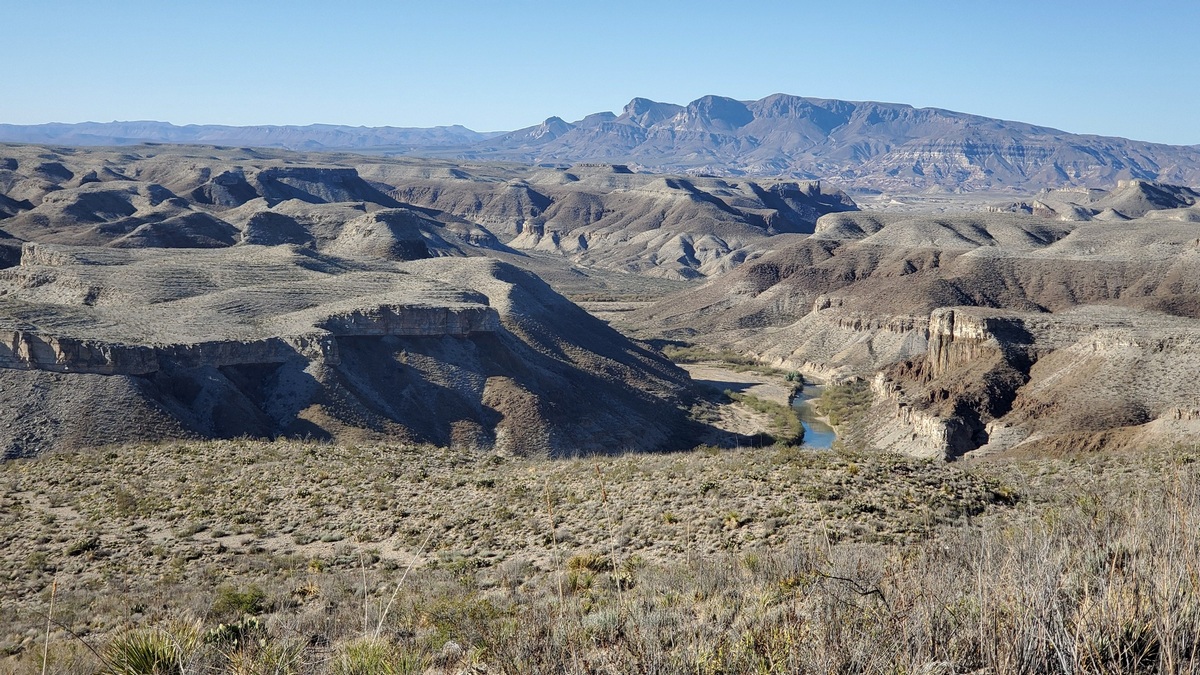
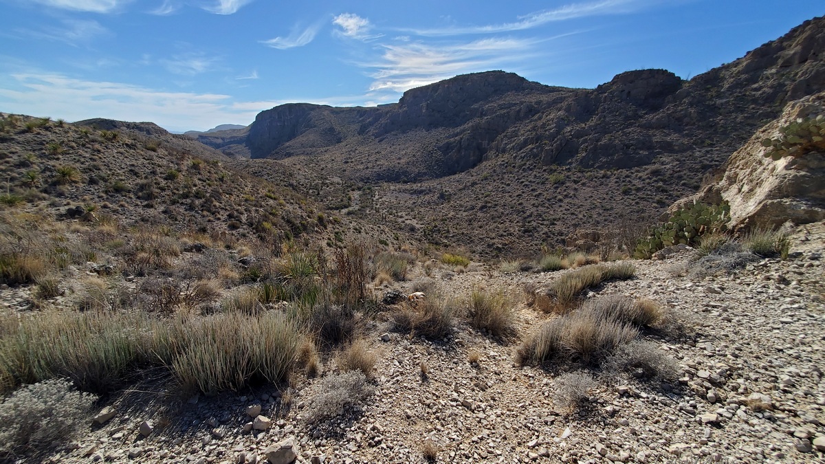
The first five pictures are in order of what we see hiking counter-clockwise. After climbing a ridge with a view of the town to the northwest we come through a cut to the south and have a grand vista across the Rio Grande, 1st picture.
Wished had walked south another fifty yards; surely would have gotten more of the river's course in the picture. So in December I did take such pictures, but the haze was pretty thick.
In Texas Mountains, an excellent book by Laurence Parent and Joe Patoski, we read that the haze many of us have seen in the national park is at least partly from a couple of coal-fired power plants along the Rio Grande to the west.
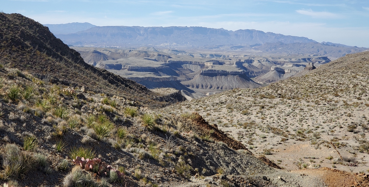
Many of us have camped/hiked in the Chisos Basin. Some have climbed Emory Peak and seen Elephant Tusk from Ross Maxwell Scenic Drive, on the west side of the central section of the park. Further to the next picture.
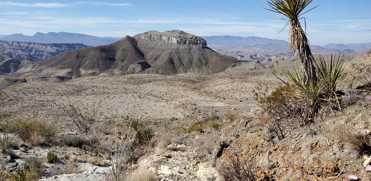
A change of plans
Started my February 2021 hike here a bit late. I was attempting the loop counter-clockwise, and so got the first picture.
Then I decided doing the whole loop was a not so bright idea, especially with the challenging/confusing north side at the end of the day. Surely it would be more interesting to shortcut across to the north side than do an-out-and-back, with so many vistas of the golf course on the way back down the ridge. Found with my navigation app what hopefully would be a reasonable spot to climb down. Thought I could turn around if really necessary.
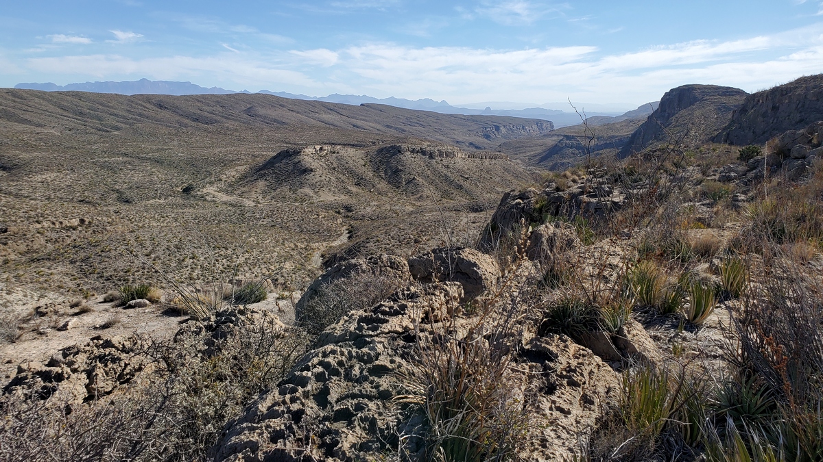
The picture below is one of several interesting sections. Turned out this shortcut was another not so bright idea, but did get down safely.
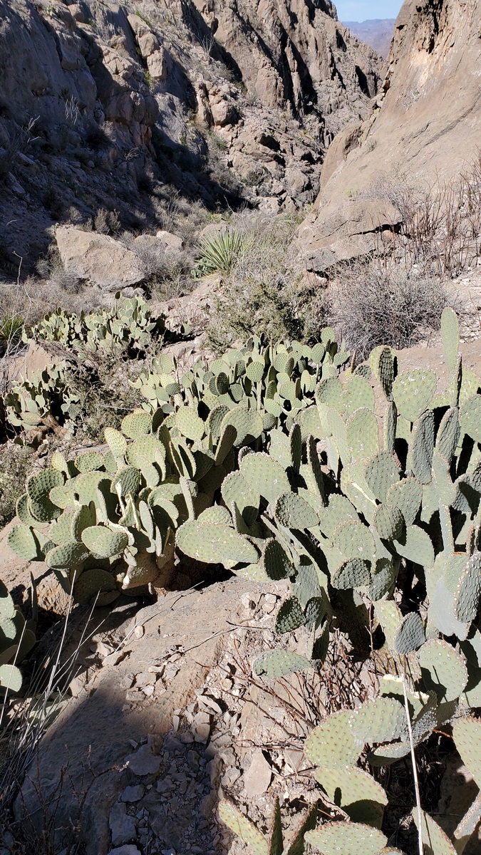
The cacti are blind prickly pear (Wikipedia). They have eyes with sharp hairs, no spines. The blindness is what is said can happen to cattle from hairs blowing off in high winds getting in their eyes. I think a Spanish giant dagger yucca is upper center.
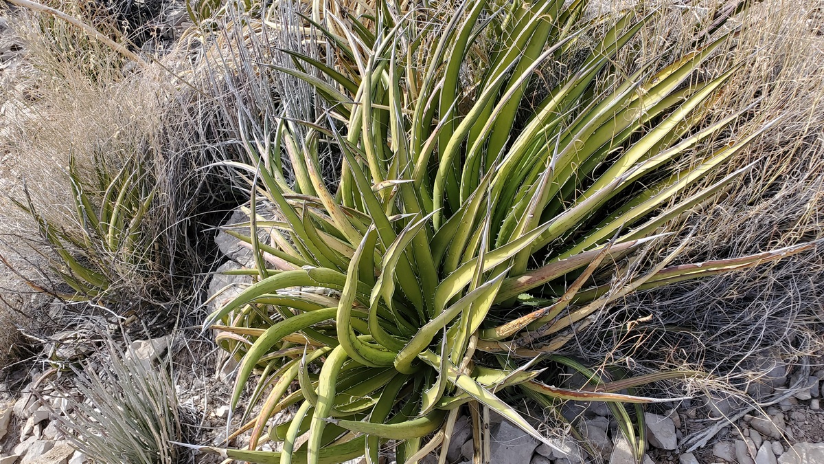
Lechuguilla
The picture below is of lechuguilla, an agave that is an indicator species of the Chihuahuan Desert. Here's the Wikipedia page. This plant flowers after five to twenty years and then dies, like nearly all agaves, unlike yuccas and sotol which keep on going.
I saw some of these plants at Big Bend Ranch state park that had been seriously torn up, likely to get at the more edible stems. Wondered if this had been done by feral hogs, feral cattle, or javelina? Probably the latter, based upon a few web pages.
There is a page with good reader comments at An Eye for Texas. And a page about how it can be processed/preserved/cooked at TexasBeyondHistory.net; though I imagine not many of us will bother.
There's an article about javelina at a park web page, with picture of one eating a prickly pear pad. And we complain about getting a spine or hair in a finger! How can javelina get away with this? There must be some evolutionary adaptations to dodge infections from punctures and put up with the annoyance.
Outings: The Call of the Wild
Visit the Alamo Sierra Club Outings page on Meetup for detailed information about all of our upcoming Sierra Club Outings.
The Alamo Sierran Newsletter
Richard Alles, Editor
Published by the Alamo Group of the Sierra Club, P.O. Box 6443, San Antonio, TX 78209, AlamoSierraClub.org.
The Alamo Group is one of 13 regional groups within the Lone Star Chapter of the Sierra Club.
Changed your contact information?
If you're not sure whether the Sierra Club has your current email address, send an email to Member Services with your name and address and/or member ID (see Locating Your Member ID) so they can add your email address to your member record.
Have you moved? Let us know by sending your old address, your new address and your member ID to: address.changes@sierraclub.org.
Go online for the latest news and events
 |