Coal Ash Ponds Threaten Groundwater & Calaveras Lake

On September 26th, the Sierra Club and Earthjustice filed comments in support of an EPA proposal to increase federal oversight of CPS Energy’s toxic coal ash ponds located at the Spruce coal plant. Among several violations of federal coal ash disposal standards, these unlined ponds are currently threatening Calaveras Lake and the area’s groundwater with contaminants that can seriously harm human health and the environment. Despite a nationwide requirement that utilities update their coal ponds by April of 2021, CPS Energy failed to bring their ponds into compliance, instead requesting a last-minute extension.
“It’s completely unacceptable to see CPS Energy kicking the can down the road on an issue that so directly affects our health and environment here in San Antonio,” said Emma Pabst, a Campaign Representative with Sierra Club’s Beyond Coal Campaign. “CPS should be working to close the Spruce coal plant because of the harm it does to our community, not spending millions of dollars on a new coal ash pond. The least CPS Energy could do is clean up the mess that it’s making. We strongly support EPA’s proposal to monitor the clean up of these toxic ponds more closely and urge CPS Energy to act as soon as possible.”
Coal ash, which is produced from burning coal in coal-fired power plants, poses numerous threats to human health and the environment. Chemicals such as arsenic, lead, and mercury can leach from unlined ponds to contaminate ground and surface water, causing cancer, developmental delays, birth defects and more in people who consume or inhale these toxins. CPS Energy’s coal ash ponds are located over the Carrizo-Wilcox Aquifer, which spans more than 60 Texas counties and supplies over 670,000 acre-feet of water per year to private well owners, municipalities, agricultural producers, and industry. The nearby Calaveras Lake is a popular fishing spot for locals. Utilities across the country have known for nearly a decade that coal ash ponds can harm human health.
The Coal Combustion Residuals (CCR) Rule, which regulates how utilities dispose of toxic coal ash, was passed under the Obama administration in 2015. The rule required utilities to update or line their ash ponds by April of 2021. CPS Energy continued to utilize its outdated ponds for years, instead approving $50 million in funding to construct a new pond in February of 2022 – nearly an entire year after EPA’s deadline.
CPS Energy’s current coal ash ponds are violating several provisions of the CCR Rule:
- CPS failed to demonstrate that the groundwater monitoring well placement and the networks for all four ash ponds are designed in compliance with required criteria.
- CPS failed to demonstrate that the groundwater monitoring well accurately represents the quality of groundwater around Calaveras Lake.
- Despite its inadequate groundwater monitoring network, CPS discovered statistically significant increases in numerous hazardous contaminants, including boron, chromium, cobalt, lithium, radium, and fluoride, as well as elevated levels of pH, calcium, and chloride, which are typically markers of additional pollutants.
- CPS tried asserting that the coal ash ponds were not the cause of the increased contamination and instead asserted that those pollutants were “naturally” occurring – an extremely flawed analysis.
- CPS failed to conduct adequate statistical groundwater analyses, as required by statute, between 2018 and 2021.
- CPS failed to properly evaluate and report combined concentrations of radium 226/228, as required by the CCR Rule.
Texas Water Supply Challenges: Deja Vu All Over Again!
Our October general meeting features Ken Kramer, the Water Resources Chair for the Lone Star (Texas) Sierra Club, discussing the past, present, and future of Texas water.
Tuesday, October 18th
6:00 pm
Meeting schedule
| Informal get-to-know-you | 6:00 pm to 6:15 pm |
| Announcements | 6:15 pm to 6:30 pm |
| Featured program | 6:30 pm to 8:00 pm |
Venue
This will be a hybrid meeting. We are asking everyone to RSVP whether you are attending in-person or via Zoom. Please visit our event page and submit the RSVP form. Subsequently, you will receive an email containing the Zoom meeting access information.
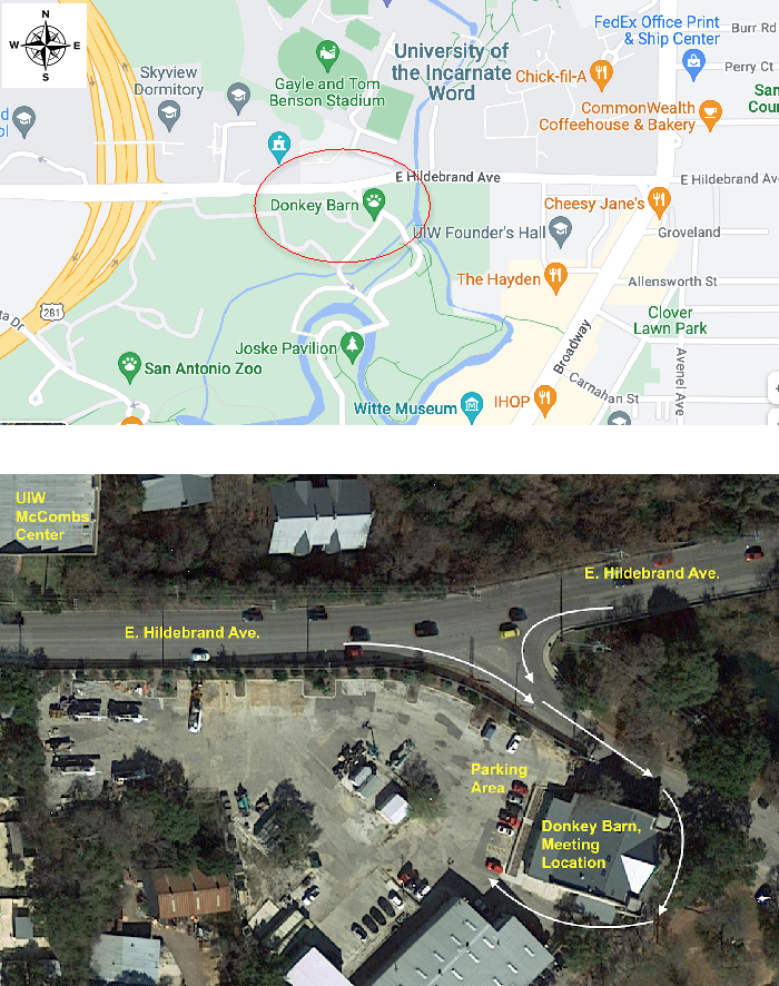
In-person location
The Donkey Barn in Brackenridge Park, 950 E. Hildebrand Ave. Entrance to the Donkey Barn is at the back of the building and a map is provided below.
Program topic
Since the historic drought of the 1950s, Texas has been grappling with how to provide a clean and dependable water supply for a growing population, and how to do so while meeting the water needs of the environment and dealing with dramatic climate changes. The Sierra Club has been an important player on the state's water issues for decades, especially in its successful opposition to the ill-advised 1968 Texas Water Plan.
The water challenges are ongoing, however, including periodic grandiose ideas to make the state one big plumbing system. Ken Kramer will provide a timely review of the past, present, and future of Texas water, as much of our state finds itself once again struggling with drought.
About our speaker
Dr. Ken Kramer is volunteer Water Resources Chair for the Sierra Club Lone Star Chapter. His Ph.D. (Political Science (Rice University, 1979) dissertation focused on the implementation of federal air and water pollution control policy in Texas.
Dr. Kramer has served on numerous advisory committees to Texas state and local agencies and officials, including as co-chair of Task Force 21, which advised the state’s major environmental protection agency on industrial air quality, water quality, and waste management (for which he received a Governor's Environmental Excellence Award, 1993). He also served on the state’s Water Conservation Advisory Council from its creation in 2007 until 2021.
Dr. Kramer currently serves on the Region H Water Planning Group and on the stakeholder committees on environmental flows for both the Brazos River Basin and the Trinity & San Jacinto River Basins & Galveston Bay. He is a member of the board and Treasurer of the Texas Water Foundation. Dr. Kramer has earned many illustrious awards for his environmental work.
He is editor of The Living Waters of Texas, published by Texas A&M University Press in 2010.
The Alamo Group of the Sierra Club holds its general meetings the 3rd Tuesday of most months. They're always free and open to the public.
View videos of our past meetings on our YouTube channel or our Facebook page.
Lennar Homes Guajolote Ranch Development Threatens to Pollute the Edwards Aquifer
The Texas Commission for Environmental Quality recently received an application to permit a waste water treatment plant that will discharge 1 million gallons/day of sewage effluent into Helotes Creek to serve a new development of 3,000 homes that Lennar Homes has planned for the 1,120-acre Guajolote Ranch site located off of Scenic Loop Road in northwest Bexar County. The prospect of discharging such a large amount of waste water into an Edwards Aquifer recharge feature is truly dismal.
A South West Research Institute study, commissioned by the City of San Antonio’s Edwards Aquifer Protection Program, warns that that installing additional wastewater systems to in the Helotes Creek watershed, regardless of type, would significantly degrade the watershed and the quality of water recharging the Edwards Aquifer.
Can we trust Lennar to protect our aquifer?
Lennar Homes is definitely not what you would call a good neighbor. In 2020 GEAA received a $175,000 settlement from Lennar and its contractors, including Pape-Dawson Engineers, for violating for violating the Clean Water Act at its 4-S Ranch subdivision.
In October 2019 muddy water and construction debris from a Lennar construction site flooded a downstream neighbor’s property, causing over $100,000 in damages.
The site of the Guajolote Ranch is currently designated in San Antonio’s official North Sector Plan as “country,” suitable for properties 10 acres or larger. Lennar’s proposal is too dense to comply with the plan. A development of this density, besides being totally inconsistent with current land uses, poses a real threat to San Antonio’s water supplies and to well-being of nearby neighbors.
Local residents are also very concerned about the increase in traffic, especially as it will impact beautiful Scenic Loop Road. The City of Grey Forest is not prepared for this kind of growth.
Sign our petition to stop this awful project
Please sign the petition telling Lennar Homes CEO Stuart Miller to stop this awful project. You can learn more details about why Guajolote Ranch a bad idea here.
GEAA is joining with our local member groups and the neighborhoods near the Guajolote tract to oppose Lennar’s waste water discharge permit. Those wishing to make a tax-deductible contribution to cover legal expenses can donate here or mail a check to GEAA at PO Box 15618, San Antonio, Texas 78212. Be sure and write “Guajolote” in the subject line.
Stay tuned for more on this and other issues by signing up to receive GEAA alerts via e-mail.
by Annalisa Peace, Executive Director, Greater Edwards Aquifer AllianceSan Rafael Desert — Southeastern Utah
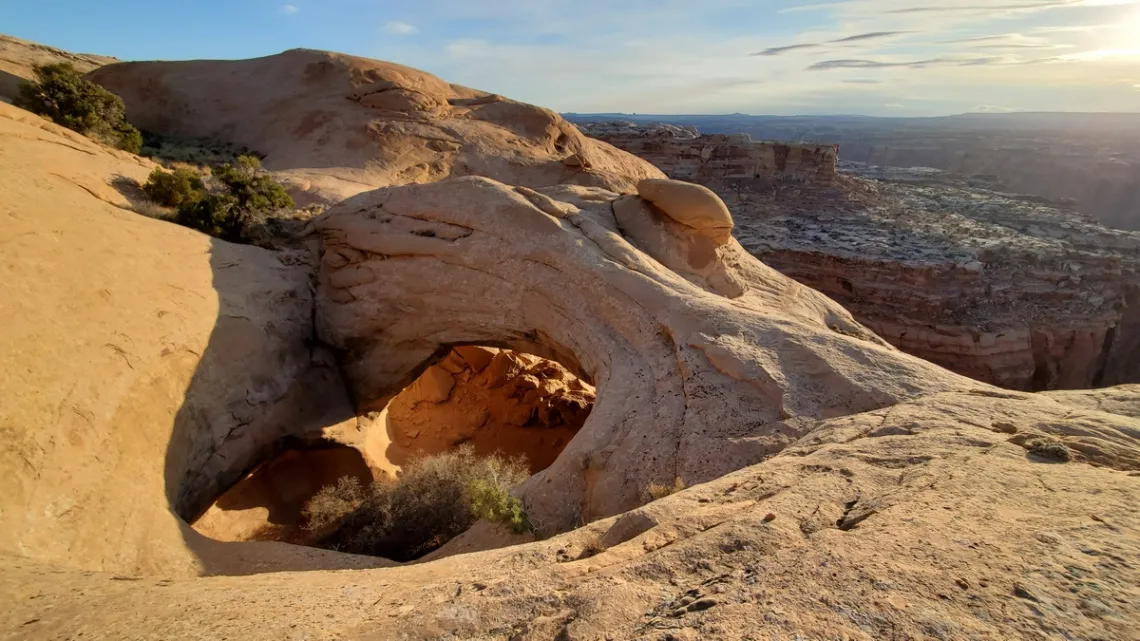
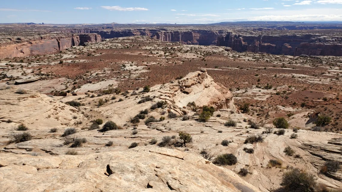
March 2021 I did a trip to San Rafael Swell (article in this newsletter, September 2022) and drove through San Rafael Desert on the way there. San Rafael Desert is east of San Rafael Swell and west of the Green River. The area between the river and Emery county road 1010, and north from Horseshoe Canyons Unit of Canyonlands National Park past Trin-Alcove Bend of the river, is Labyrinth Canyon Wilderness. This was designated at nearly 54,600 acres in 2019. A page for this wilderness is at Wilderness.net, including a map.
John Wesley Powell named this section of the Green River gorge Labyrinth Canyon on his 1869 expedition down the Green and Colorado rivers. The Green joins the Colorado in Canyonlands National Park Needles District, 32 miles southwest of Moab. Rafting the Green is quite popular, now using rubber rafts, not wooden boats like Powell had (Powell lost a boat on the Green at Disaster Falls, Lodore Canyon, in what is now Dinosaur National Monument). Here is a rafting guide.
And here is a detailed Emery county map, PDF (have to zoom way in to see labels). We can drive northeast from Hanksville on UT hwy 24; at 13 miles we pass the turnoff west to Goblin Valley State Park and some of the southern swell hikes, particularly the Little Wildhorse and Bell canyons loop (article in September, 2022 newsletter).
It is 19 miles on UT 24 to the turn east on county road 1010, on which it is 31 miles to the Horseshoe Canyon unit of Canyonlands National Park (good hike to pictograph panels from a campground at the trailhead, no water or services). Just before Horseshoe Canyon road 1010 turns north and goes 6.5 miles to Keg Knoll road, which goes east to the trailhead for Colonnade Arch and Bowknot Bend, first 4 pictures below. Nice at-large camping near the trailhead, but the road is high clearance particularly near the end and likely impassible when wet.
There are good details on hiking Colonnade Arch at RoadTripRyan.com with better pictures than mine (1st picture). He has a separate page for Bowknot Bend. It is about 8.2 miles total round trip to Bowknot including the side trip to Colonnade Arch. Or 2.4 miles round trip to Colonnade Arch only.
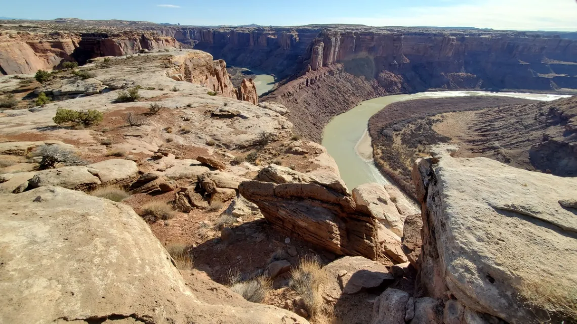

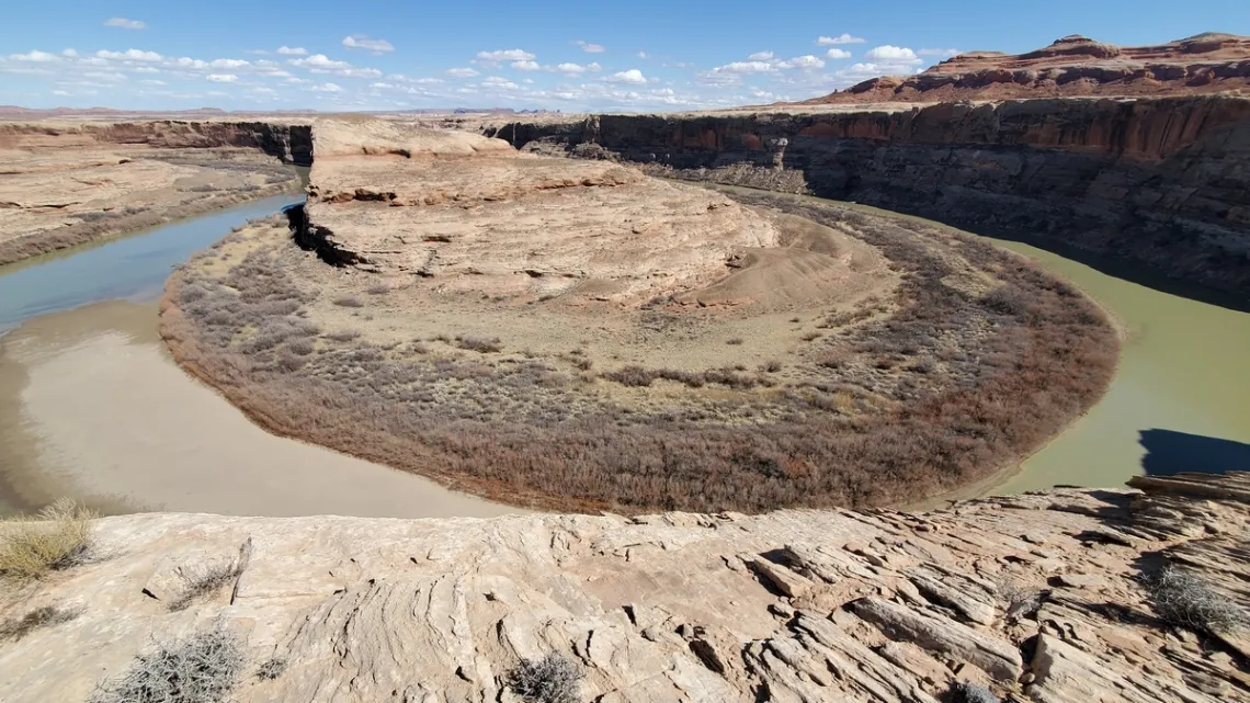
Another interesting view is at Trin-Alcove Bend of the Green, picture below; turn off county road 1010 12 miles north of Keg Knoll Road. It is a few miles drive to the rim, with the last 1.5 miles being high clearance, but it is easy to park halfway in and walk.
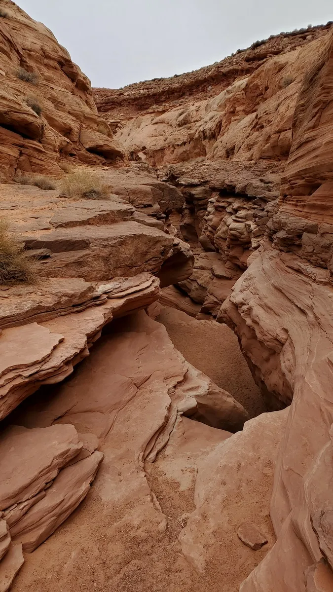
Just south of the Trin-Alcove Bend turnoff on county road 1010 is the turnoff west for Moonshine Wash, a loop hike, rather more challenging than the other two in this article! Part of Moonshine is not a “wash”, but a slot canyon with serious chimneying to be done. Haven't done much of this and didn't have a rope to pull up my pack. Couple young women that had also been camping at-large near the trailhead were coming along in the “wash”. They appeared at a rather challenging spot where I was chimneying back up after turning around; tossed them my pack as needed to have my back to the wall. Surely they made it around ok. Here's a webpage on Canyoning Techniques, including a bit on chimneying with photos.
Court Rules Against Comal Citizens for 1500-acre Quarry
In a disappointing decision on September 29th, a three-judge panel of the Third Court of Appeals reversed the district court ruling to strip the air permit from Vulcan Materials for its proposed 1500-acre quarry between New Braunfels and Bulverde. The appellate decision effectively restores the TCEQ air quality permit to Alabama-based Vulcan Materials, sidestepping contamination issues raised since 2017 by an alliance of Comal County citizens, concerned community groups, and organizations such as Comal ISD and Greater Edwards Aquifer Alliance.
Read the press release by Stop 3009 Vulcan Quarry for additional information.
by David Drewa, Stop 3009 Vulcan QuarryFrom the e-Mailbag
From time-to-time, the Alamo Group receives messages concerning local environmental issues. If you have thoughts to share on any of these issues, send us a message and we'll forward it to the writer.
The views and opinions expressed here are those of the authors individually and do not reflect the views or opinions of the Alamo Group or its members.
Exciting conference on healthier eating
President Biden had a White House Conference on Hunger, Nutrition, and Health on Sept 28th. He is looking for ideas for a national strategy for healthier eating. Here are the items I jotted down from another site about the initiative.. He is interested in these areas:
- Treat food as medicine.
- Focus on the quality of calories and not just quantity.
- Expand access to delivery and lifestyle counseling.
- Support food entrepreneurship.
- Increase the number of new farmers growing healthy foods using regenerative farming techniques.
- School meals are free for all students.
- Establish a food czar, a national director of food and nutrition.
Hope some ideas are added to these. Thanks.
submitted by Barbara M.The San Antonio Refinery
Same place, different names, but has not stopped flaring in years: The San Antonio Refinery -TSAR. San Antonio River Authority is the only entity that publicly prosecuted.
submitted by Rachel C.
Outings: The Call of the Wild
Visit the Alamo Sierra Club Outings page on Meetup for detailed information about all of our upcoming Sierra Club Outings.
The Alamo Sierran Newsletter
Richard Alles, Editor
Published by the Alamo Group of the Sierra Club, P.O. Box 6443, San Antonio, TX 78209, AlamoSierraClub.org.
The Alamo Group is one of 13 regional groups within the Lone Star Chapter of the Sierra Club.
Changed your contact information?
If you're not sure whether the Sierra Club has your current email address, send an email to Member Services with your name and address and/or member ID (see Locating Your Member ID) so they can add your email address to your member record.
Have you moved? Let us know by sending your old address, your new address and your member ID to: address.changes@sierraclub.org.
Go online for the latest news and events
 |