Coal Burning in SA Nearing Its End
Our local electric and gas power provider, CPS Energy, is owned by the City of San Antonio, and thus by the citizens. We benefit greatly from funding provided to the city budget by CPS. CPS is governed by an appointed Board of Trustees that is approved by City Council. CPS is accountable to the people of San Antonio as a result, and its policies and actions are expected to align with the best interests of our citizens.
For a long time the Board sent the city money and received little scrutiny from our elected officials, or the larger community. In fact CPS was accountable only to powerful business interests.
Many may remember the strong public opposition to construction of the Spruce 2 coal plant, which was ignored. This project was pushed by our business “leaders” and imposed a billion-dollar debt on ratepayers. The plant was completed in 2010 and is expected to run until 2060 or later.
Spruce ditching coal by 2028
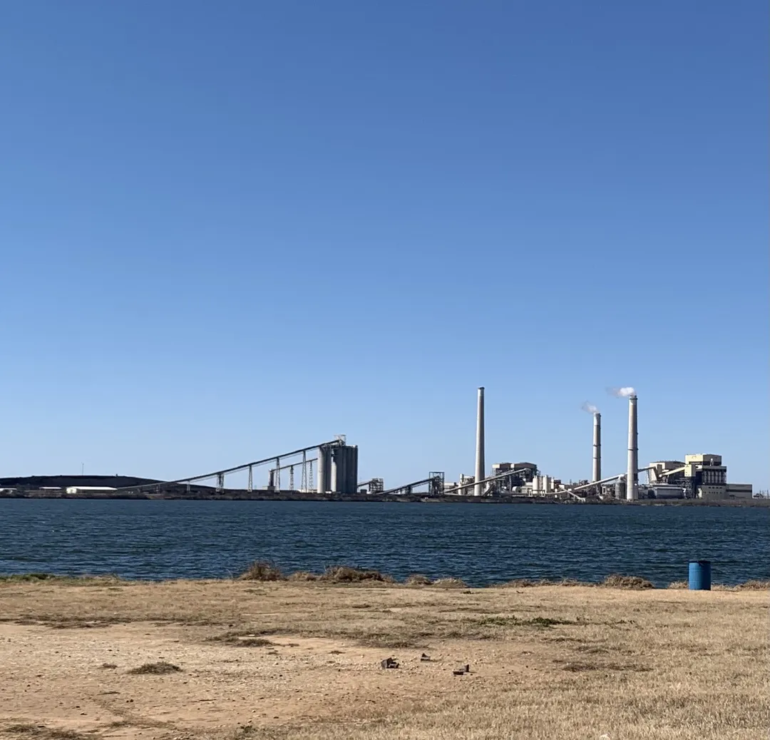
It is with tremendous gratitude that we finally see CPS plans to stop using coal at both Spruce power plants by 2028. Many social justice and environmental groups, including Sierra Club, have pushed for a decade to achieve this result.
Shutting the Deely coal plant was an earlier success, and easier as it was a much older and dirtier plant than either Spruce unit. The last several years have seen our Sierra Club and other groups become more aggressive in our demands for transparency and true public dialogue at CPS. Climate urgency and environmental justice cry out for this, and gradually the Mayor and CPS Board have begun to listen and engage with the full community.
Natural gas usage to increase
CPS has a new, more open, leader in Rudy Garza and climate change denier Ed Kelly is off of the Board. CPS has a new citizen Rate Advisory Committee (RAC) that has worked hard over the last year to examine rate design and generation planning. In this process dialogue and listening were achieved and nine different portfolio generation mixes were examined. They chose Portfolio 2 (P2), which provides for conversion of Spruce 2 from coal to gas, and will barely meet our city’s Climate Ready goals by 2030, and miss 2040 goals badly.
The RAC majority believe that gas is more reliable than the renewables favored in P9. This argument was once again proved fallacious over the Christmas weekend, when extensive gas shortages, due to freezing pipelines, pumps etc, were reported across much of the country. The shortages resulted in huge spikes in prices, rolling black outs etc.
We saw the same problems in Storm Uri less than 2 years ago. We will be paying on the cost of that gas shortage event for decades. Renewables can be as reliable as fossil fuels, especially with energy storage, enhanced efficiency and demand management.
The RAC studies clearly show that enhanced efficiency is cost effective, so hopefully CPS and COSA will return to this subject and approve the more ambitious proposals they rejected last winter. Proper rate design can also alleviate the massive number of delinquent bills CPS is experiencing.
Even with P2, we can celebrate the end of coal burning in San Antonio, which will help our air quality and health as well as our climate. We will continue to push for an end to all fossil fuel burning, including gas, in the near future.
by Terry Burns, Alamo Group memberWe Can’t Slash Emissions Without Low-Cost Energy Storage
Let’s acknowledge that fossil fuels are incredibly useful. First, they are extremely energy dense. A gallon of gasoline contains as much energy as the mid-day sun delivers to a square foot of the ground in 300 hours.
Second, fossil fuels can deliver a lot of power. A gasoline pump in the US delivers 6-8 gallons per minute, which in energy terms is equivalent to 20,000 horsepower. What would our ancestors have said if we told them we could capture the energy produced by 20,000 horses over a few minutes, store it in a small container in the back of a wagon, and use it to travel 300 miles in just a few hours?
Third, fossil fuels are relatively safe and easy to store. We feel comfortable traveling at high speeds in a box containing as much energy as 100 pounds of dynamite.
Lastly, fossil energy is available to us whenever we need it. We can pile the kids into the minivan and drive to grandma’s house whether the sun is shining or not.
These features have delivered enormous benefits to our society over the past two centuries: increases in life expectancy, reductions in poverty, conveniences our ancestors could not have imagined. Of course, we are now painfully aware of the enormous risks to our health and safety associated with burning fossil fuels.
I write this not to engender guilt or to advocate for a return to a pre-fossil fuels lifestyle, but rather to highlight the enormous challenges we will face in the next few decades. Developing new energy storage technologies that deliver the energy density, power, safety, and convenience we are used to will not be easy, but it is essential if we are to reach our decarbonization and sustainable development goals.
Here, I’ll highlight two applications of energy storage. The passenger EV market has grown substantially over the past decade, due largely to reductions in the cost of lithium-ion batteries. But challenges remain; currently, only 1% of cars on American roads are electric.
Improvements needed in EV energy storage
Batteries store only about 10% as much energy by weight as gasoline, so manufacturers need to pack a lot of batteries on board to achieve a range of 300 miles or more. This makes EVs expensive. Furthermore, we have gotten used to “charging” gasoline-powered cars at 6 gallons per minute---20,000 horsepower---but today’s fastest EV superchargers deliver only 330 horsepower. These two challenges also make it very difficult to electrify larger vehicles, such as trucks, airplanes, and cargo ships.
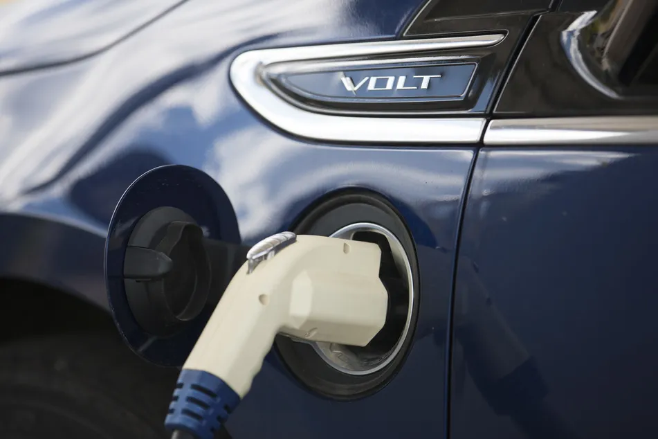
Researchers around the world, including those in my research group, are developing lithium batteries that can charge faster and store more energy than today’s batteries. Our focus is the negative side of the battery---the anode. Conventional anodes are made of a lithium-graphite composite. Removing the graphite and using only lithium offers a potential 10-fold increase in energy density as well as faster charging. But pure lithium is very chemically reactive, so we need to modify the separator between the positive and negative halves of the battery to mitigate the associated safety risks.
Intermittency of wind/solar generation necessitates massive storage capacity
Our electrical grid also needs energy storage, since renewables, unlike fossil fuels, are intermittent. Texas curtailed 10% of the solar generation and 5% of the wind generation in 2020, mainly during periods when supply exceeded demand and there was not enough storage to take up the excess. Curtailment has increased over the past 5 years and will continue to do so if energy storage installations lag wind and solar installations. We will not be able to achieve 100% renewable electricity without energy storage on a massive scale.
Although many utilities are starting to use lithium-ion batteries to store excess electricity, they are too expensive for storage over periods of days or weeks. We need cheaper alternatives. Currently, most of our energy storage capacity involves pumping water uphill into reservoirs, but it is difficult to expand this capacity further, especially given ongoing droughts in many mountainous parts of the US. Low-tech solutions involve heating rocks or graphite, or pressurizing air. My research group is investigating low-cost materials that store energy by chemically binding to water.
We need to demand more investment in energy storage from our elected officials. Heating rocks may be less glamorous than installing solar panels, but it is an essential technology for our energy transition. As consumers, we can alleviate the need for more storage by running our dishwashers and charging our EVs at night, when renewable electricity is abundant, rather than at 5 pm when everyone returns home from work. Let’s help pave the way towards a society powered by 100% renewable energy.
by Sam Greene Ph.D, Postdoctoral Researcher at UT-AustinThe El Malpais Lava Field — Northwestern New Mexico
This area is south of Grants off I-40. Much of it is in El Malpais National Monument with additional area surrounding in El Malpais National Conservation Area. Here's the park map (PDF). There was another article in this newsletter July 2019 about this national monument with a few pics.
South from I-40 we can drive along highway 53 and highway 117, on the north and east sides of the national monument. Those links are to park pages about stuff to do there. This article contains updates and pictures from a visit April 2022.
What to see/where to camp
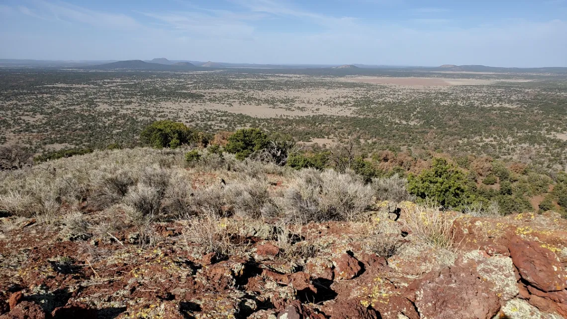
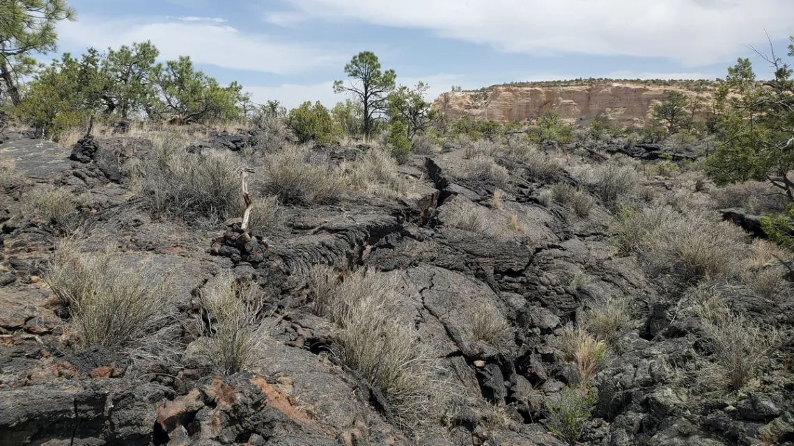
The lists of stuff from the highways pages above are good. Driving south on hwy 117 from I-40 we pass the ranger station at 9 miles and then Joe Skeen campground at 12 miles. In the list of particular interest are Sandstone Bluffs viewpoint, the east end of the Zuni-Acoma trail (3rd and 4th pics), Narrows Rim trail and Lava Falls loop.
Then we might drive back north and west on I-40 to hwy 53. 21 miles south on 53 we are at the west end of the Zuni-Acoma trail (arguably a bit easier than the east end). At 25 miles we are at the turnoff for the fun El Calderon loop (pic in the July 2019 issue linked above). The visitor center is 28 miles from I-40.
The only campground is Joe Skeen (no water), but there is at-large camping along Chain of Craters road (section below). There is water at the ranger station (access limited to when open) and the visitor center, which seems I remember has an outside faucet, important for CDT (Continental Divide Trail) hikers. Can't remember ever having seen any standing water or running creeks anywhere. Limited cellular service, particularly off the highways.
After visiting here we would surely be sorry if don't also do El Morro National Monument, 17 miles west of the visitor center along hwy 53, article July 2016. Serious archeology and history along a great loop trail, and a nice campground.
The Big Tubes area!
Here's the brochure. 4.5 miles south on Chain of Craters road (next section) from hwy 53 there is the turnoff east. Then 3 miles to the trailhead; this bit of “road” is mostly loose sand, no prob with high clearance though was badly rutted due to someone driving through when it was soaked. I centered over the ruts, no problem. AWD advised.
There are campspots with a toilet at the trailhead. Couple picnic tables and grills, but no fires allowed this visit.
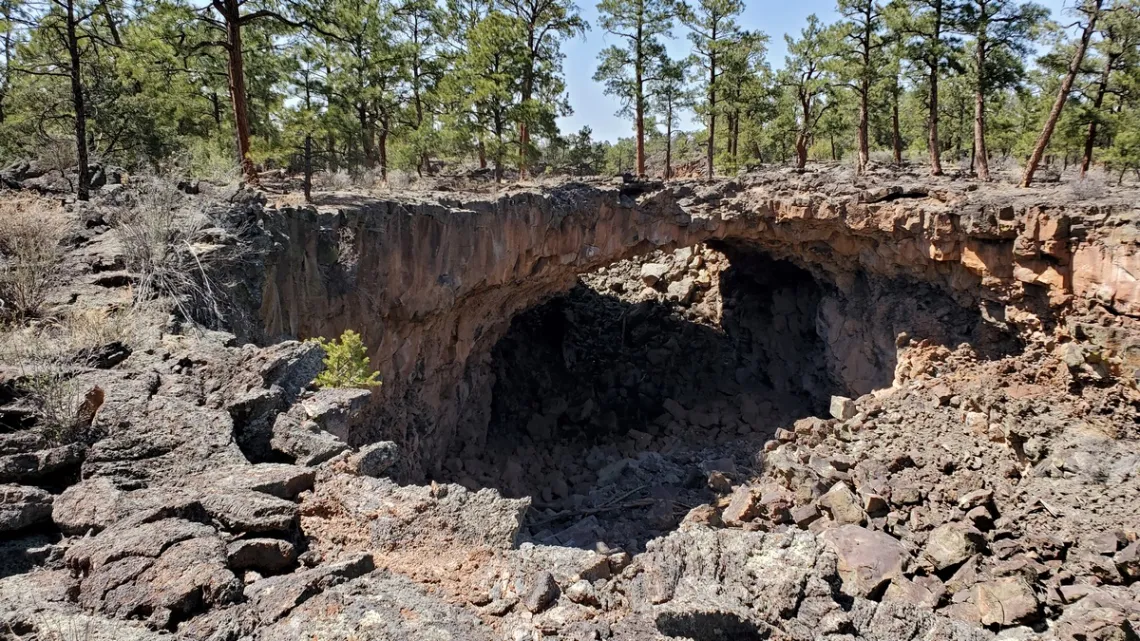
The “trail” is pretty well cairned, total distance including 2 loops around 2 miles. Along the north loop there is Caterpillar Collapse, a big collapsed tube. Along the south loop there is the Seven Bridges section (next picture). And a number of caves, which were closed this visit, signs said due to limited resources (park staff) and safety issues. If we do get to visit the caves a permit is required, which entails education and sanitation to prevent transmitting white nose syndrome to bats, a serious fungal disease.
Best we pay close attention to our route; spot the next cairns, then look back and note the previous and what the terrain looks like in the other direction. It wouldn't be hard to get a bit lost if wandering and not knowing which way is which due to overcast conditions. Maybe we are sure our navigation app is keeping track, but then we drop/smash/lose our phone. Also: trekking poles are a great help with balance in many spots. But keep hands out of the pole straps in case of a fall; don't want to get tangled up and unable to put hands out before hitting a knee, shoulder or head. Learned this the hard way on another trip.
Chain of Craters Road!
The turnoff is south and west 26 miles along hwy 53 from I-40. This high clearance road, county road 42, impassible when wet, goes south 33 miles to hwy 117, where it is 35 miles north back to I-40. Drove this with hiking buddies, picture in the July 2019 issue; one buddy commented on the road quality. Was hoping for a great road spot picture for this article further to that comment. I could see the bypasses created by visitors at the formerly deeply rutted swampy spots, but the whole road was dry and well graded this visit.
This road is very lightly used, only saw two other vehicles this time. Best to be well prepared for vehicle problems and have more water than we could possibly need; someone else might need some. No cell service.
South along Chain of Craters there are turnoffs for the various “craters” which are cinder cones. No signs. Of note is Cerro Brillante, the southernmost one, pic below. Reasonable short hike up the east side; poles with baskets were extremely helpful. Like climbing a sand dune, small lava fragments and finer grained stuff. Could see my car below beside the road from couple spots. This was nice as was imagining reaching the road with failed phone navigation app; is the car north or south?
The Zuni-Acoma trail!
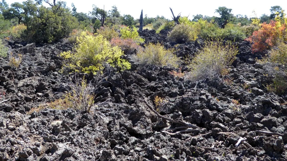
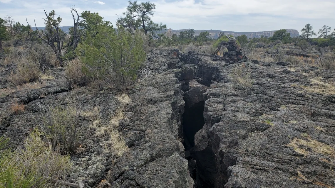
This is a 7.5 mile route, each way, that connected the pueblos of the Zuni and Acoma tribes. Here's the park page with specifics and photos. And see the next two pictures. Pottery fragments dating as early as 850 CE have been found, with most evidence dating to 1050-1150 CE. This route is included in the CDT, so in addition to the cairns there are some markers for that. This crosses McCarty's flow at the east end and the Bandera flow at the west/north end, with loose sand sections in the middle. See the next section about this volcanism stuff.
Can we understand this volcanism stuff?
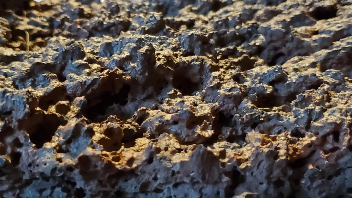
Noticed the lava at east side of Zuni-Acoma trail looked very young; rather prickly. Closeup pic of this lava below. Lava at Big Tubes was smoother, but wouldn't want to land a knee on it. Had to figure this out a bit. Here's the park page about the lava flows at El Malpais. Found a page with detailed info; a flows map and ages table.
Now we can understand somewhat. The east side of Acoma-Zuni is McCarty's flow, only 2,000-3,000 yrs old, that's why is almost painful to touch. Correlating the flow map with park map can see the flow at the north end of Chain of Craters road is the Bandera flow, 9,000-10,900 years old. Big Tubes area is also Bandera. A ways down Chain of Crater road from the north that lava flow disappears.
There is the El Calderon flow at the north edge of the park, this is 115,000 years old, the oldest here. A picture from the El Calderon cinder cone was included in the above linked July 2019 issue. Apparently this started as an eruption and then turned into a flow as viscosity decreased.
From the map the Chain of Craters cinder cones are "older basalts", eruptions, not flows. Found a good background page on lavas. So, eruptions as opposed to flows? Yellowstone (January 2019 issue), Mt St Helens (November 2017) etc eruptions were felsic magmas (high viscosity), the Malpais flows must have been mafic (low viscosity). The viscosity is higher with increasing fraction of silicon in particular.
CPS Energy: A Utility in Transition
San Antonio’s City-owned electric and gas utility has shifted from a gas utility to one with sizable stakes in coal, nuclear, wind, and solar, delivering electricity to more than 900,000 areas residents. It’s also our largest climate offender and generator of toxic materials released to the air, water, and land.
But a CPS commitment to zeroing out its carbon emissions by 2050—and expected shuttering its last coal plant by 2030—show a possible pathway to progress.
Editor's note: Visit Deceleration's CPS Energy Resource page for comprehensive background information about CPS as well as links to past (and future) stories about CPS and San Antonio's Climate Adaptation Plan.
by Greg Harman & Marisol Cortez, Ph.D., Independent Journalists & Co-editors of Decleration
Outings: The Call of the Wild
Visit the Alamo Sierra Club Outings page on Meetup for detailed information about all of our upcoming Sierra Club Outings.
The Alamo Sierran Newsletter
Richard Alles, Editor
Published by the Alamo Group of the Sierra Club, P.O. Box 6443, San Antonio, TX 78209, AlamoSierraClub.org.
The Alamo Group is one of 13 regional groups within the Lone Star Chapter of the Sierra Club.
Changed your contact information?
If you're not sure whether the Sierra Club has your current email address, send an email to Member Services with your name and address and/or member ID (see Locating Your Member ID) so they can add your email address to your member record.
Have you moved? Let us know by sending your old address, your new address and your member ID to: address.changes@sierraclub.org.
Go online for the latest news and events
 |