Conversion to Fracked Gas is a Costly Mistake
Editor's note: this piece was also published in the January 27, 2023 edition of the San Antonio Express-News
More than 10 years ago, San Antonio’s utility, CPS Energy, decided to close an old coal plant and replace it with a fracked gas power plant in nearby Seguin. Despite warnings from environmental and public interest groups about trading one pricey and polluting energy source for another, the utility charged ahead.
Now here we are, a decade later, and unhealthy smog encases the city and bills are higher than ever. And CPS Energy just repeated the same mistake. On Monday, CPS Energy made a crucial decision that impacts ratepayers who pay the bills, city residents who breathe the air, and the environment and climate that so often suffer from our choices.
On one hand, the utility committed to closing its last remaining coal plant — a commendable move and one that many utilities across the nation have recently made. Unfortunately, CPS Energy then locked in decades of dependence on volatile fracked gas. Again.
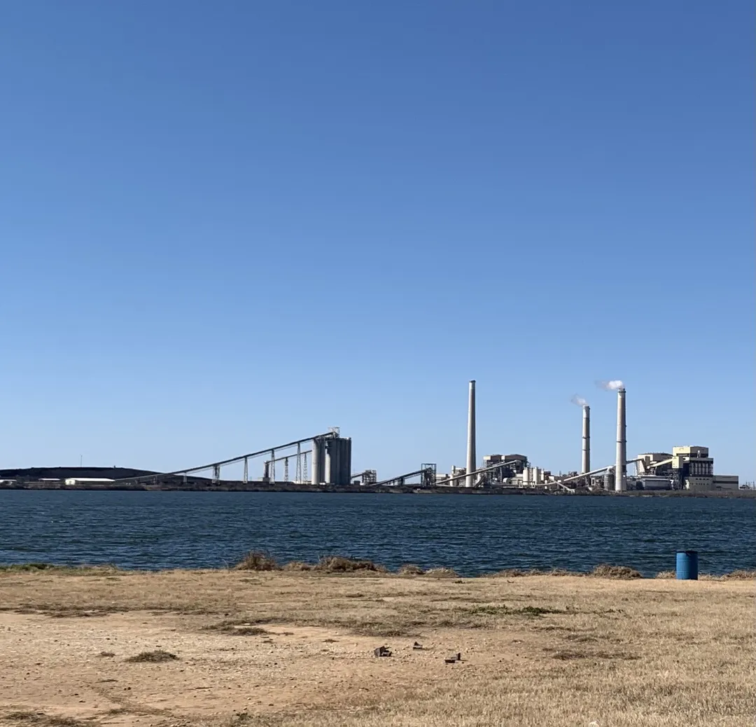
The CPS Energy board had several options for how to replace the energy generated by its Spruce coal plant, including cost-effective and reliable solutions like renewable energy, battery storage and energy efficiency. But the option favored by a majority of the utility’s board of trustees will convert over half of Spruce to run on gas until 2065.
CPS Energy has once again kicked the can down the road, claiming it’s not quite ready to fully harness clean energy. In 2019, CPS Energy executives said the utility needed to slow its transition to renewable energy sources so it didn’t have to rely on “new … big power plants.” Well, CPS Energy is going to create that new big power plant anyway while continuing to shun lower-cost, cleaner solutions.
This bewildering support for dirty fuels comes despite clean energy being the most affordable source (massive new federal funding should make this even cheaper) and a majority of Texas voters wanting more action on climate change. Last year, CPS Energy customers saw rates increase and bills shoot to record levels as gas prices increased.
We must push back against the reliability claim: The failure of gas plants during the February 2021 winter storm was the leading cause of billions in debt for ratepayers and grid blackouts.
San Antonio voters, who elected a mayor and City Council that passed a climate action plan in 2017, know fracked gas is not a climate solution. Methane, the primary component of gas, warms our environment more than 80 times faster than carbon dioxide emissions from coal. Scientists estimate that at least 25 percent of today’s global warming is driven by methane, outpacing the decline in emissions from coal.
Gas plants also produce dangerous air pollutants that threaten San Antonians’ health and combine with other chemicals in the atmosphere to form ozone smog, causing lung inflammation, asthma and other respiratory conditions. San Antonio has repeatedly failed to meet federal standards for smog pollution.
The CPS board had several strong options rooted in the economics and common sense of renewable energy sources, storage and energy efficiency. But it stuck with the status quo. It went the route it has traveled before. As if we haven’t already been there and learned where the path leads.
by Emma Pabst, Beyond Coal Campaign Representative, Sierra ClubAcross Southern New Mexico — Vistas, Geology and History
This is about traveling east to west across the southern part of the state, with detours north and south on the west side. Spectacular views of course and interesting stuff to learn, and lots of places to camp, some for free. We may feel a little guilty about burning up gasoline, but hopefully we won't have a monster pickup truck hauling a mobile home.
Refuge from diminishing habitat
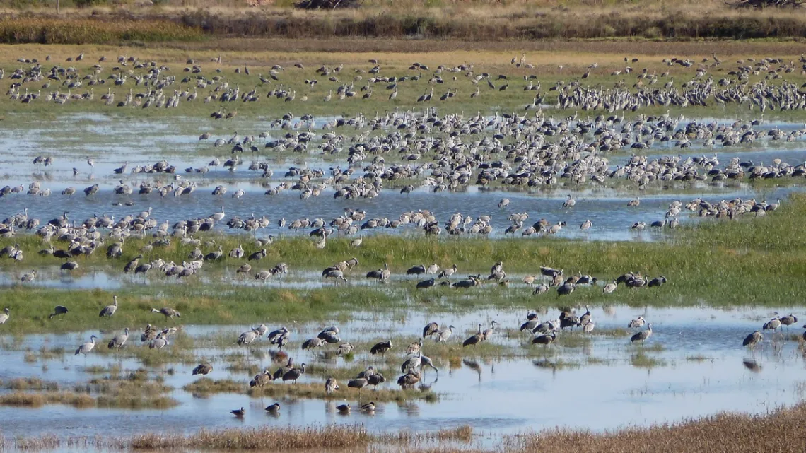
After crossing the New Mexico state line on US 380, in 80 miles we are just east of Roswell. North is Bitter Lakes National Wildlife Refuge (NWR). Sandhill cranes in particular winter here; the first picture is further to an article in the July 2013 issue of this newsletter. South of US 380 here is Bottomless Lakes State Park.
Further about NWRs; we know how critical these are, particularly for migrating birds in the US, due to the conversion of wildlife habitat, particularly wetlands, to farm and ranch lands. In particular I am thinking of Balmorhea State Park, part of which I believe used to be a serious wetland; likely was a major destination of sandhill cranes each year. Now they mostly have to hang out winters at NWRs, where they are quite spectacular, but maybe we should try to think of what used to be.
Through Roswell 63 miles further we are at Fort Stanton-Snowy River Cave National Conservation Area, lots of horseback riding/bicycling/hiking trail mileage, mostly south of US 380. There are two campgrounds, the west one developed. Haven't done much here myself except use at-large camp spots in the east one.
The book Apache Voices by Sherry Robinson is a profound recounting of persecutions, forced migrations and war against the various Apache tribes in the 19th century. Fort Stanton (Wikipedia) was a base of US Army operations particularly against the Mescalero Apaches. Another related memorable book is Indian Country by Peter Matthiessen.
Extreme heat — natural and man-made
Through Carrizozo 36 miles further west we are in the middle of a vast lava flow. The Valley of Fires Recreation Area is, to quote the website,:
"...located immediately adjacent to the Malpais Lava Flow. Approximately 5,000 years ago, Little Black Peak erupted and flowed 44 miles into the Tularosa Basin, filling the basin with molten rock. The resulting lava flow is four to six miles wide, 160 feet thick and covers 125 square miles. The lava flow is considered to be one of the youngest lava flows in the continental United States. From a distance, Valley of Fires appears as barren rock but when you walk through the nature trail there are many varieties of flowers, cactus, trees and bushes typical of the Chihuahuan desert”.
Nice developed campground in this rec area.
Another 47 miles west on US 380 we are at the Trinity nuclear test site historical marker (Wikimedia Commons page with photo). This is about the first atomic bomb test, not far south in what is now White Sands Missile Range, July 16th 1945.
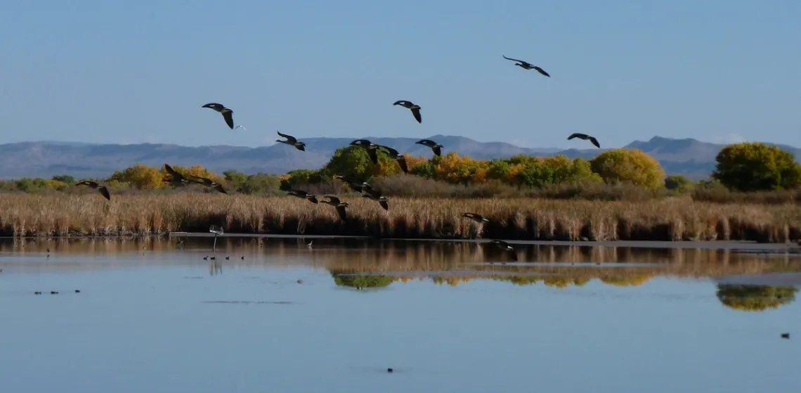
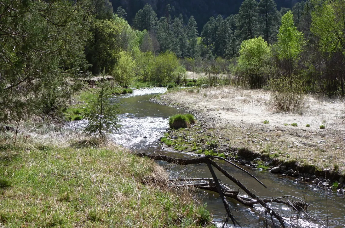
Another 11 miles and we are at the Rio Grande; just south is Bosque del Apache NWR (picture below). Somewhere near here there is a historical marker for Journada del Muerto (Journey of the Dead Man), Wikipedia. This is a 90 mile section of Camino Real de Tierra Adentro (Royal Road of the Interior Land), PDF brochure. The 404 mile section of the latter in the US is now part of the National Historic Trail System.
Jogging north a bit on I-25 we can take US 60 west from Socorro. In 8 miles there is Box Recreation Area to the south. There are technical climbing opportunities and campsites. Another 8 miles and there is the turnoff south to Water Canyon campground in the Magdalena Mountains, Cibola National Forest.
Driving another 33 miles through Magdalena we are at the NRAO VLA (National Radio Astronomy Observatory Very Large Array) picnic area on US 60. Picture below; there is a museum via a drive in south. This array is one member of NRAO's Very Long Baseline Array, along with a radio telescope in the Davis Mountains among others.

This area is a serious pièce de résistance. We are near the middle of the Plains of San Agustin. Wikipedia says this area lies “...within the Mogollon-Datil volcanic field, just south of the southeast edge of the Colorado Plateau, and west of the Rio Grande Rift Valley. The basin is a graben (a down-dropped block which subsided between parallel faults).” The VLA was located here to minimize radio noise, being in a vast low empty plain between mountain ranges.
Carrying on west from the VLA picnic area 14 miles we are at Datil Well Recreation Area. A historic cattle drive route came through here; we can look at the old water wellhead and cattle trough. There is a nice campground. And a 3 mile loop trail, with a detour to a high point from which we can get a glimpse of some of the VLA antennae down on Plains of San Agustin. Just west on US 60 we are in Cibola National Forest. Believe the turnoff south I've taken to at-large camp spots is 3.5 miles west of the rec area.
From the rec area the Continental Divide is 10 miles west. Another 11 miles on US 60, just past Pie Town, we are at the turnoff north for county rd 603, which is on the CDT (Continental Divide Trail) route.
At this point on US 60 we are 56 miles east of the Arizona state line. Continuing west in Arizona we can drive up the Mogollon Ridge, which is the southeastern corner of the Colorado Plateau. But never mind about that now.
Detours north
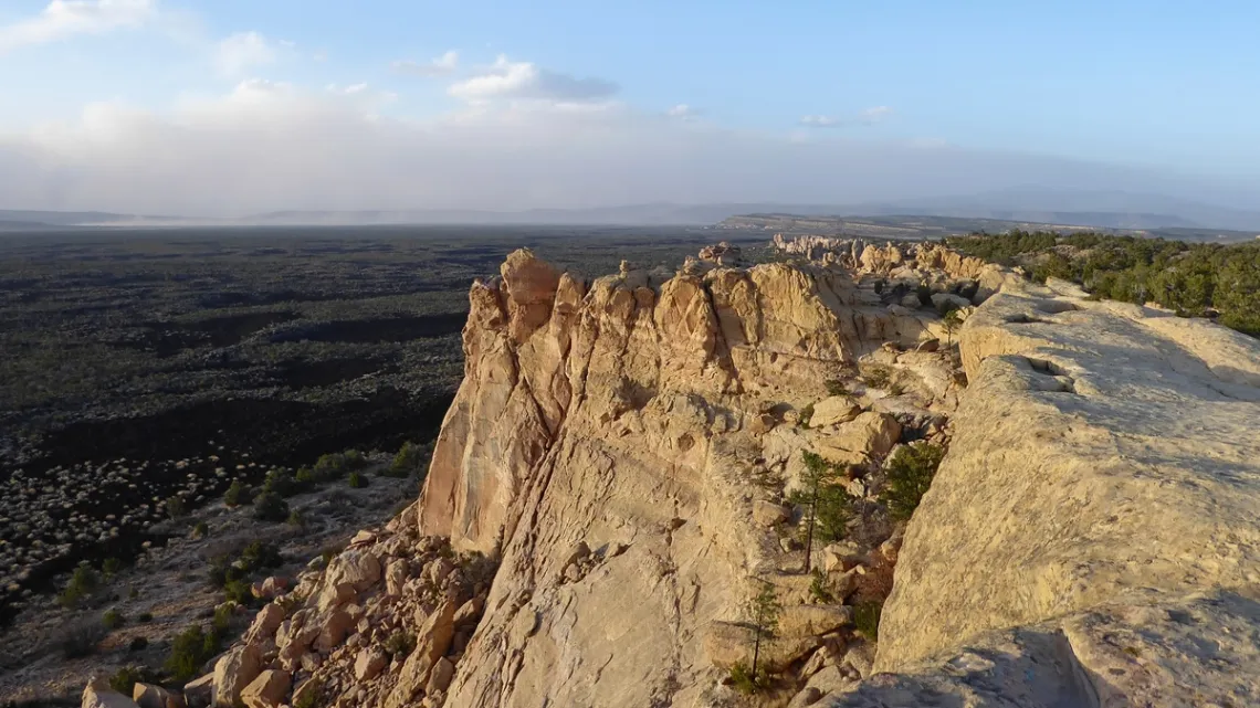
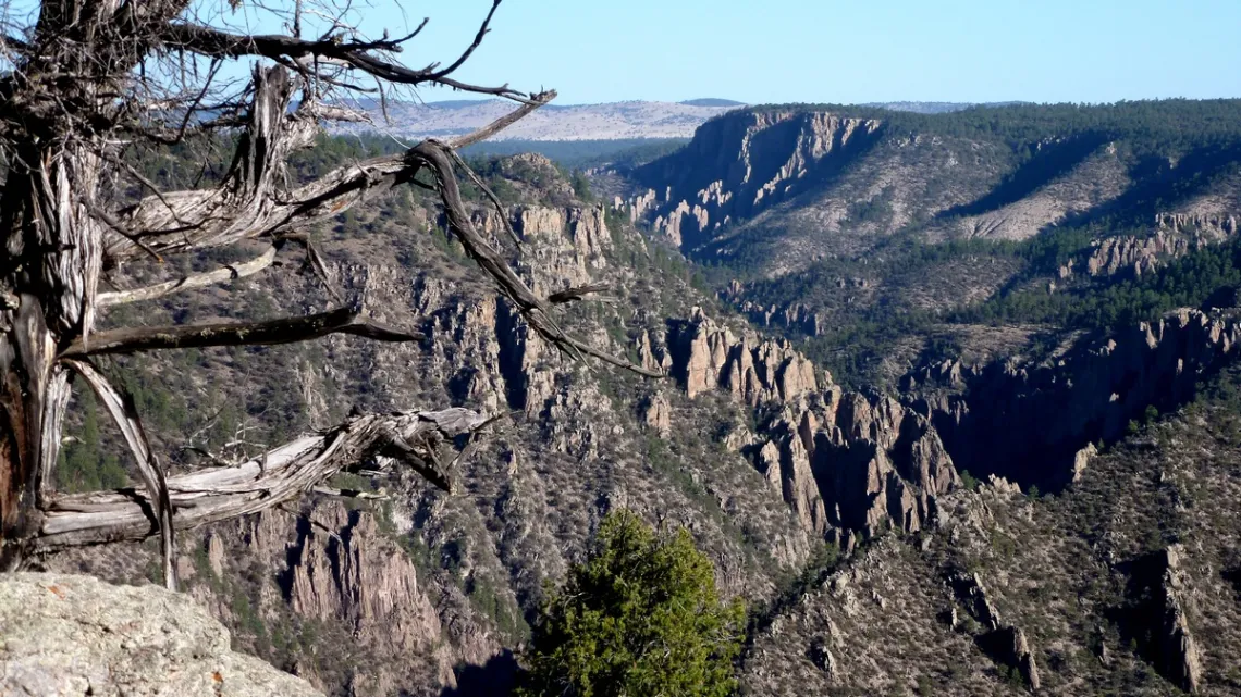
Following the CDT north: county rd 603 from Pie Town to hwy 36 to hwy 117, 24 miles, we at at a turnoff for county rd 42. Here is a CDT sign at the south end of Chain of Craters road in El Malpais National Conservation Area, with El Malpais National Monument just north. These were the subject of articles July 2019 and January 2023; details on the local volcanic history particularly in the latter.
Nineteen miles further on hwy 117 is the eastern trailhead for the Zuni-Acoma Trail, which follows an ancient route connecting pueblos of those tribes. The CDT also follows this west, 7.5 miles across the El Malpais lava flow in the national monument to hwy 53. Not far due west off hwy 53 is El Morro National Monument (article July 2016), very historic with a nice campground.
Detours south
The next town west on US 60 from Pie Town is Quemado. From there driving south on highways 36 and 12 through Gila National Forest we get to US 180. South on US 180 we pass some primitive campgrounds, and 42 miles south of the junction with hwy 12 there is Aldo Leopold Vista Picnic Area.
From this section of US 180 there are hiking routes along the Gila River, including in Gila Wilderness. The latter was the first US wilderness area, established largely by the work of Aldo Leopold (article March 2021). I did a 3 day backpack loop in this wilderness from Gila Cliff Dwellings National Monument April 2012. This is at the north end of hwy 15, 43 miles north of Silver City. City of Rocks State Park is rather neat, not far southeast of Silver City.
After the bit in Gila Wilderness I did a hike in Aldo Leopold Wilderness which is just east. I think that was from Emory Pass on hwy 152 to Hillsboro Peak, 8 miles out-and-back.
Found a page by folks who also got here. They met the fire lookout on the tower, as I did. The lookout asked if I had read Grizzly Years: In Search of the American Wilderness by Doug Peacock.
Had not but now have, and also read two others of his, Walking It Off: A Veteran's Chronicle of War and Wilderness and Was It Worth It? A Wilderness Warrior's Long Trail Home. Peacock was a Green Beret medic who dealt with PTSD by photographing grizzlies. He would camp in the nastiest brushy spots as the bears would avoid those. Peacock was the inspiration for Edward Abbey's George Washington Hayduke character in The Monkey Wrench Gang and Hayduke Lives!. There was a bit about Peacock and Abbey at the end of an article July 2022.
by Kevin Hartley, Sierra Club Life Member
Outings: The Call of the Wild
Visit the Alamo Sierra Club Outings page on Meetup for detailed information about all of our upcoming Sierra Club Outings.
The Alamo Sierran Newsletter
Richard Alles, Editor
Published by the Alamo Group of the Sierra Club, P.O. Box 6443, San Antonio, TX 78209, AlamoSierraClub.org.
The Alamo Group is one of 13 regional groups within the Lone Star Chapter of the Sierra Club.
Changed your contact information?
If you're not sure whether the Sierra Club has your current email address, send an email to Member Services with your name and address and/or member ID (see Locating Your Member ID) so they can add your email address to your member record.
Have you moved? Let us know by sending your old address, your new address and your member ID to: address.changes@sierraclub.org.
Go online for the latest news and events
 |