The Henry Mountains and Horseshoe Canyon, Southeastern Utah
I was thinking would finally climb Mt. Hillers in the Henrys, then do Horseshoe Canyon, on the way for a few bits in San Rafael Swell and San Rafael Desert. The latter two were subjects of articles in this newsletter in the September 2022 and October 2022 issues. This was March 2021.
The Henrys
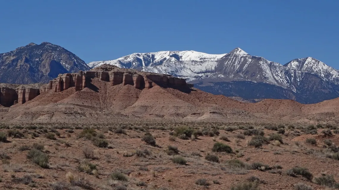
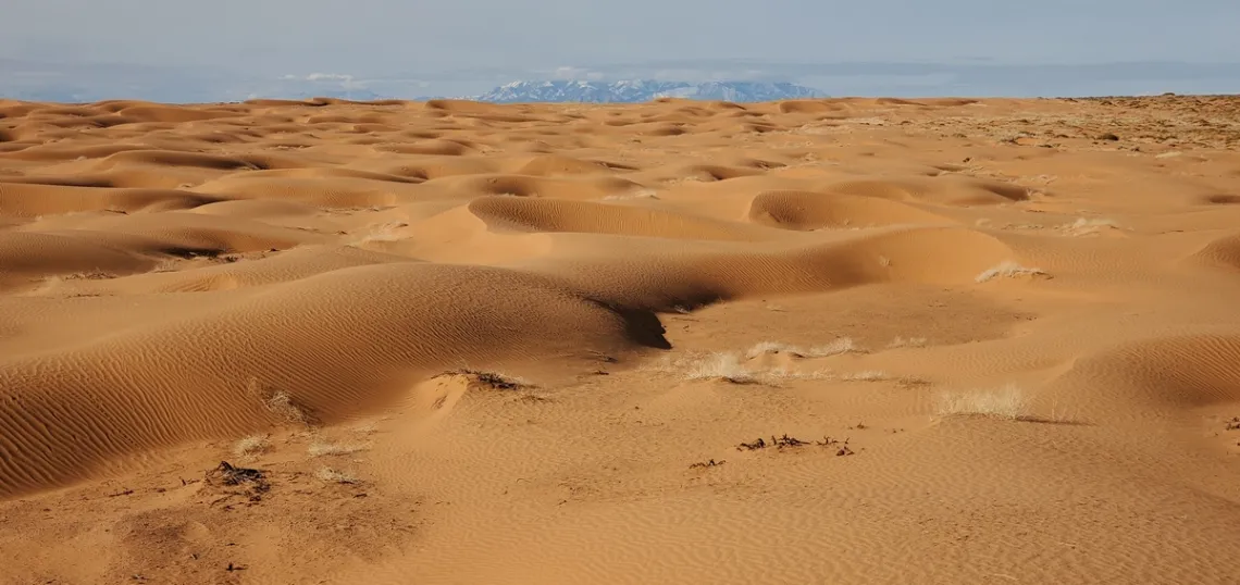
The Henry Mountains was the last range added to maps in the contiguous 48 states. Here is the Wikipedia page and one with a map and bunch of detail at AmericanSouthwest.net. There are three principal peaks southwest of Hanksville; Ellen, Pennell and Hillers (first four pictures) and Holmes and Ellsworth further southeast (fifth picture). These two groups are separated by highway 276, which runs from highway 95 south of Hanksville south to Bullfrog marina on Lake Powell.
Years ago I read an article on climbing Mt. Ellen from Lonesome Beaver campground. To avoid driving north and then a long road south I decided to drive in from the east and do a shorter road north.
But not all roads are created equal; turned out the latter was very rough and narrow with steep dropoffs. No place to turn around; had to back out. Not a bright idea solo without a full-size spare wheel etc for my old Outback. Saw nobody else up there. Got out ok; very educational.

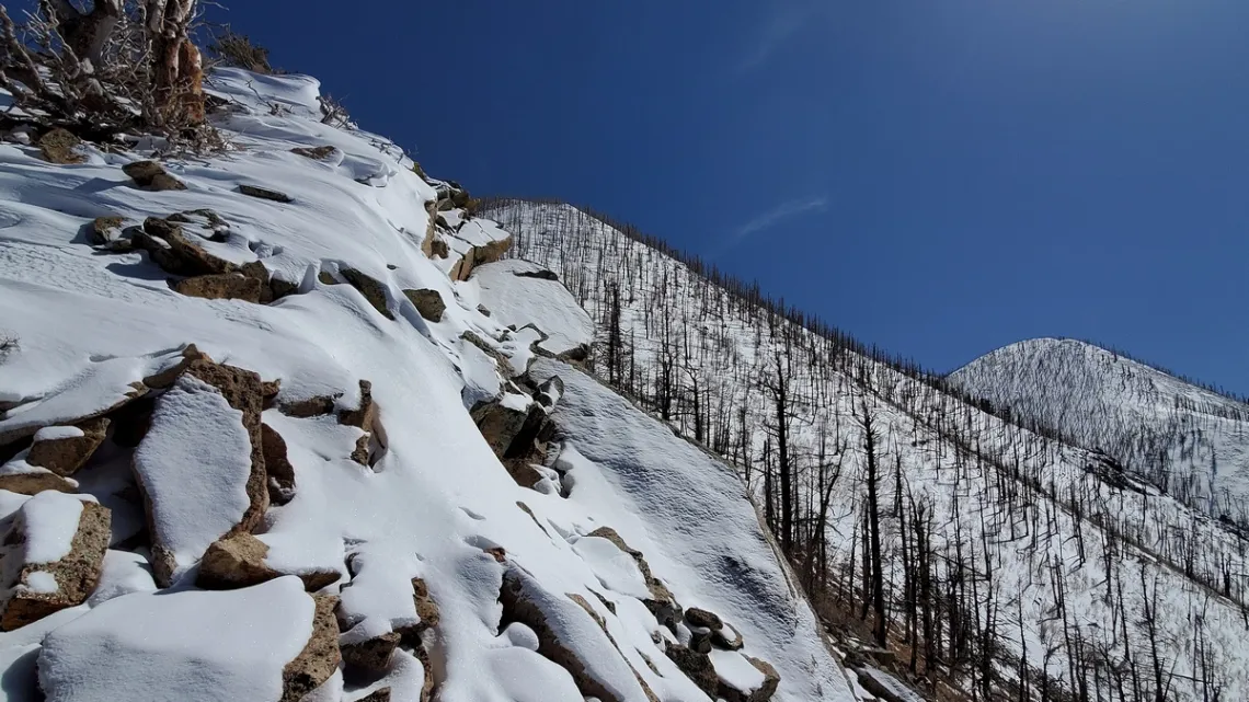
In March 2021 had another bright idea; climbing Mt. Hillers, lower than Ellen and the trailhead is accessible from a “reasonable” road. Saw nobody else on the road or the mountain, not even footprints in the snow left over from the serious storm in February. Wasn't hard to get to a pass, center in the fourth picture, not much snow up to there.
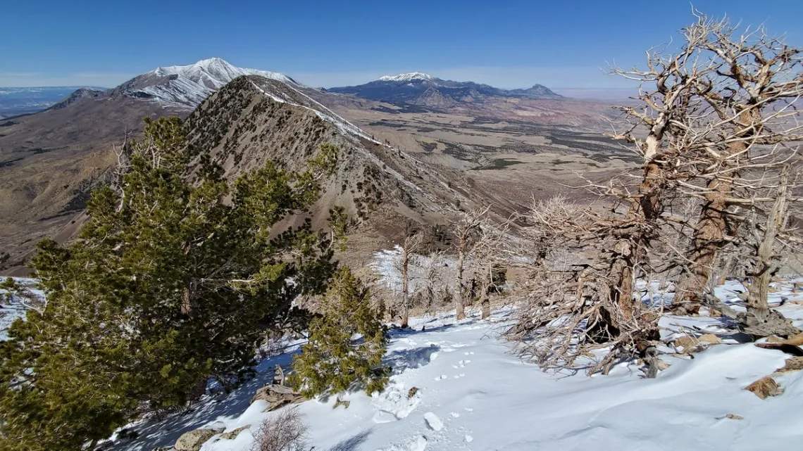
But then I could see there would be deep snow in spots above, and didn't have snowshoes or snow baskets on my poles. So decided to just try for a lesser summit, next two pictures, didn't quite make it. And then climbed down the wash to the north of Hillers, where the real route is. Apparently had forgotten why I didn't climb up there.
The snow in the wash was very deep; so that was a quarter mile of postholing up to 4' deep back down to the reasonable section. But it was vastly easier postholing downhill than up. The poles were a great help, even with summer baskets. Was able to climb out of postholes with help of the poles placed horizontally.
A great memory and again very educational. Starr Springs campground along the road in was very nice; nobody else there even on a weekend.
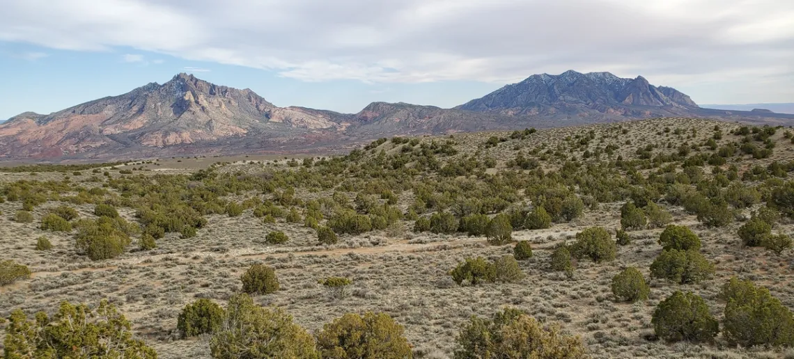
Searching for info about the wildfire resulting in the above picture's scene I found a 2015 BLM article, Long-Term Vegetation Change in Utah’s Henry Mountains (PDF). This resulted from a study comparing historical and new photos of the same vistas, and analyzing the vegetation coverage.
From the article:
...the Henrys were very heavily grazed during the late 1800s and early 1900s. Mount Pennell had been so overgrazed [by domestic sheep] that [we] had trouble finding a place where [we] could pasture our horses... At the time of our fieldwork (1935–1939) the range in the Henry Mountains region had been greatly damaged, not only by erosion, but by deterioration in the type and quantity and forage.
In large parts of the desert, the shrubs were closely trimmed and stubby; [while] in the mountains oak brush thickets were leafless as high as sheep could reach [termed highlining]…. The overgrazing was caused not only by too many animals but by grazing too early in the spring and by crowding stock near watering places.
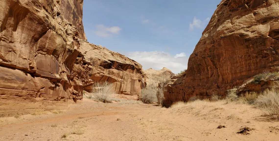
Horseshoe Canyon Unit of Canyonlands National Park
Here's the NPS page. This unit was added to Canyonlands in 1971. Artifacts have been found dated as early as 9000-7000 BCE and as recently as 500 CE. Fremont and Ancestral Puebloan peoples were also here though briefly in comparison with the others.
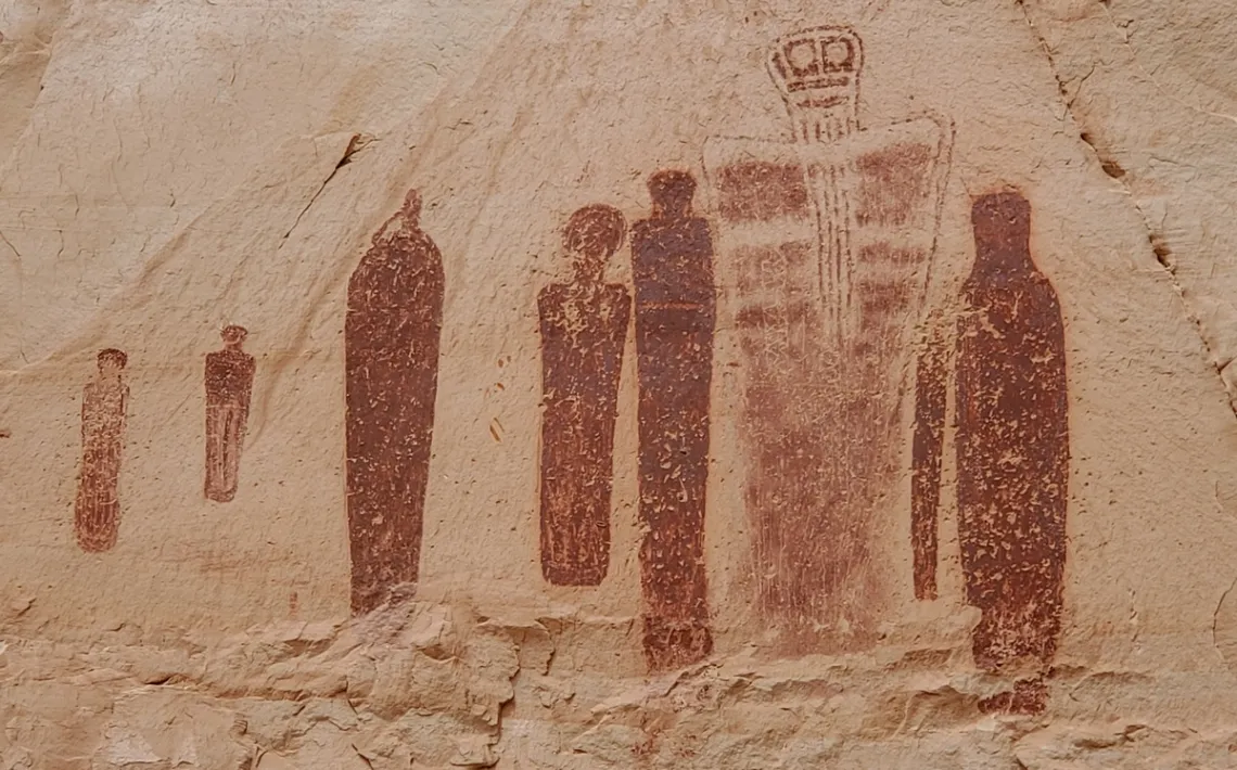
A chief attraction is the four major pictograph panels. Round trip from the trailhead to the furthest one, Great Gallery, (next picture) is 8 miles, max elevation difference about 600'.
Here's a page at RoadTripRyan.com with a map, pictures and bunch of explanation. There is free primitive camping at the trailhead, with a toilet but no water.
The Great Gallery, next picture, is the largest of the panels in Horseshoe Canyon. A Natural History Museum of Utah page says the 60' long panel is thought to have been done between 2000 BC and 0 AD.
The page quotes Ed Abbey regards this panel, from Desert Solitaire:
These are sinister and supernatural figures, gods from the underworld perhaps who hover in space, or dance, or stand solidly planted on two feet carrying weapons - a club or sword. Most are faceless but some stare back at you with large, hollow disquieting eyes.
Demonic shapes, they might have meant protection and benevolence to their creators and a threat to strangers: beware, traveler, you are approaching the land of the horned gods....
Educational, but Ethical? The Tension within Historic Skeletal Collections
Our June general meeting features Jennifer Barron, Ph.D., discussing the ethics of historic skeletal collections, how we view them, and our stewardship of them.
Tuesday, July 18th
6:00 pm
Meeting schedule
| Informal get-to-know-you | 6:00 pm to 6:15 pm |
| Announcements | 6:15 pm to 6:30 pm |
| Featured program | 6:30 pm to 8:00 pm |
Venue
This meeting will not be webcast on Zoom. Attend in-person at:
William R. Sinkin Eco Centro, 1802 North Main Avenue
Map
Program topic
Historic skeletal collections in the US that were assembled during the 19th and early 20th centuries have recently come to the forefront of ethics discussions in biological anthropology. Most, if not all of these collections were amassed prior to landmark guidelines such as the Nuremberg Code, or the Belmont Report in which research subjects are afforded voluntary participation, beneficence, justice, and informed consent.
Knowing that these collections do not follow today’s bioethical guidelines for research, and are contradictory to today’s theoretical paradigms, how do we view these collections and our ongoing stewardship of them? What steps do we take to mitigate the ethics within a collection if they also provide and educational component?
Within American institutions, an unknown number of human remains reside in historic skeletal collections, amounting to above-ground necropolises. Currently, there is no existing best practice industry standard for the treatment of non-Indigenous historic human remains used for teaching, research, and display within institutional collections.
By recognizing that these collections are composed of disempowered individuals who were dissected and studied without their consent and working to produce an applicable best practice policy, this research produces the first document offering tangible solutions for the museum, biological anthropology, and bioethical fields.
About our speaker
Jennifer Barron is a career museum professional who has worked within academic and institutional settings interpreting collections for over 15 years. Current and past projects include collaborating with a team of scholars, educators, and museum professionals to complete the transformation of the Witte Museum in San Antonio, Texas (2011-2016), collaborating on forensic casework for Operation Identification, and NAGPRA repatriation.
Education
PhD, Applied Anthropology, Texas State University, San Marcos, TX
MLitt Museum and Gallery Studies, University of St Andrews, St Andrews, Scotland
BA Anthropology, University of Missouri- Columbia
In 2017, with the guidance of Dr. Michelle Hamilton, Barron curated the Grady Early Skeletal Pathology Collection in the Forensic Anthropology Center at Texas State (FACTS) which led to her doctoral research in ethics and informed consent within human remains collections. Barron received her BA in anthropology from the University of Missouri- Columbia and her Master of Literature in Museum and Gallery Studies from the University of St Andrews, Scotland. She recently completed a PhD candidate in the Applied Anthropology Program at Texas State University.
The Alamo Group of the Sierra Club holds its general meetings the 3rd Tuesday of most months. They're always free and open to the public. View videos of our past meetings on our YouTube channel or our Facebook page.
From the e-Mailbag
From time-to-time, the Alamo Group receives messages concerning local environmental issues. If you have thoughts on any of these issues, send us a message and we'll forward it to the writer.
The views and opinions expressed here are those of the authors individually and do not reflect the views or opinions of the Alamo Group or its members.
Partner Spotlight: Rachel Cywinski
The Meadows Center for Water and the Environment recently published this story about Alamo Group member Rachel Cywinski's work as a Texas Stream Team community scientist with the San Antonio River Authority's "River Warriors" program.
submitted by Rachel Cywinski
Outings: The Call of the Wild
Visit the Alamo Sierra Club Outings page on Meetup for detailed information about all of our upcoming Sierra Club Outings.
The Alamo Sierran Newsletter
Richard Alles, Editor
Published by the Alamo Group of the Sierra Club, P.O. Box 6443, San Antonio, TX 78209, AlamoSierraClub.org.
The Alamo Group is one of 13 regional groups within the Lone Star Chapter of the Sierra Club.
Changed your contact information?
If you're not sure whether the Sierra Club has your current email address, send an email to Member Services with your name and address and/or member ID (see Locating Your Member ID) so they can add your email address to your member record.
Have you moved? Let us know by sending your old address, your new address and your member ID to: address.changes@sierraclub.org.
Go online for the latest news and events
 |