On Numbers and Climate Action
In 2008, Professor David MacKay, of the University of Cambridge, published a book titled Sustainable Energy – without the hot air. In it, he argues for the intelligent use of numerical comparisons to guide our policies and personal actions to address environmental issues such as climate change.
Numbers, when discussed without context or comparison, can be misleading. He offers an example: since cell phone and laptop chargers use energy when they are plugged in but not in use, we can unplug them when we finish charging our devices to save electricity. If every UK citizen implemented this suggestion, the country would save enough electricity to power 66,000 homes each year.
This would be a huge win for the environmental activism movement, right? Not when compared to total domestic electricity use in the UK, MacKay argues. Just as 66,000 is 0.25% of the total number of homes in the UK, the amount of electricity used by idle chargers is 0.25% of the total electricity used by the average UK home.
Using some simple back-of-the-envelope calculations, MacKay gives a nice sense of which parts of our everyday lives require the most energy and have the greatest environmental impacts. Based on MacKay’s assumptions, the four biggest contributors to the average person’s energy usage — and therefore greenhouse gas emissions — are:
- buying consumer goods (36%)
- driving (24%)
- heating and cooling (22%)
- flying (18%)
Is anyone else surprised? So much of the environmental messaging I have seen has centered on recycling, composting, installing compact fluorescent lightbulbs, bringing my own bags to the market and filling them with organic, locally grown kale. Most of these actions do little to address those four contributions.
I don’t mean to suggest these actions aren’t important, but they alone are unlikely to bring about change at the scale needed to solve our biggest environmental challenges. Such change will of course require coordinated action on the part of governments, corporations, and nonprofits, but I believe we can accelerate such action through our votes, activism, conversations, and consumer behavior.
So, I encourage all of us to focus our efforts on the actions that matter most, guided by numbers, context, comparisons, and expert opinions. As our society decarbonizes and corporations face more public pressure to clean up their acts, I suspect we will see more initiatives and suggestions that seem good at face value but have little impact. We can do a lot of good by asking ourselves, our communities, and our elected officials whether we are spending our valuable time and dollars most effectively.
A footnote: MacKay’s book is freely available at withouthotair.com. Reading it significantly changed my personal behavior. For example, after I learned about the huge environmental impact of manufacturing and shipping new consumer goods, I have been buying most of my electronics and clothes used. I have learned that it has become much easier over the past few years to find high-quality used products online.
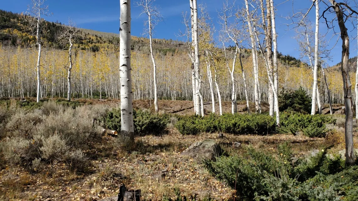
by Sam Greene, postdoctoral researcher at the University of Texas at AustinPando Aspen Grove and the “Little Grand Canyon” in Utah
Pando Aspen grove
From the Wikipedia article: "Pando (Latin for 'I spread'), also known as the trembling giant, is a clonal colony of an individual male quaking aspen (Populus tremuloides) determined to be a single living organism by identical genetic markers and assumed to have one massive underground root system. The plant is located in the Fremont River Ranger District of the Fishlake National Forest at the western edge of the Colorado Plateau in south-central Utah, United States, around 1 mile southwest of Fish Lake.
Pando occupies 108 acres and is estimated to weigh collectively 6,000 tons, making it the most massive known organism. The root system of Pando is estimated to be several thousand years old, placing Pando among the oldest known living organisms.
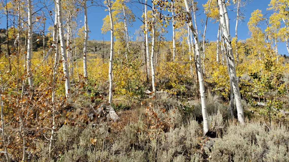
Pando's long-term survival is uncertain due to a combination of factors including drought, human development, grazing, and fire suppression. The Western Aspen Alliance is studying the tree in an effort to save it in collaboration with the United States Forest Service. In areas of Pando lacking adequate protective fencing, grazing animals have prevented Pando from developing enough young stems to fully replace existing older stems as they die. This decline in recruitment of young stems began in the 1980s and has been attributed primarily to mule deer, though Pando also undergoes restricted grazing by domestic cattle and is potentially browsed by elk."
Closing part of Pando from grazing with a high fence is fine for the purpose of study. But this is of course unnatural. There should be some grazing by deer and elk, though cattle aren't natural. With extermination of wolves and maybe mountain lions there are too many deer and elk. So let's bring back the predators!
A trophic cascade would result (Wikipedia), as happened in Yellowstone National Park with the re-introduction of wolves, a keystone species (a bit in this newsletter June 2020). Another good explanation of that phenomena at Nature.com.
What is a single organism?
Ok, all these aspen are male and have the same genome, so came from the same root system. But: about the lower third of the grove was cut off by construction of hwy 25 which is now paved.
Found a blog by the Utah Public Lands Program of Grand Canyon Trust. I asked about the impact of the road on this organism. Got the following reply from a staff member:
"I've wondered the same thing, and we don't know the answer for sure. My hunch is that they probably are connected under the highway. My colleague said 'The road bed has been there at least 70 years and aspen roots can reach up to 150 feet from mature trees. Having said that, we have no way of knowing for sure whether they are definitely connected. If they are not connected, is it still the same organism? Well, yes and no. Both sides of the road are genetically identical, but (assuming disconnection) two physically separated bodies; sort of like a worm that lives on after being severed. Probably a philosophical answer is best.'"
Oldest living organisms
The Pando root system may be several thousand years old. But much older are some bristlecone pines (article in this newsletter December 2017); one in Ancient Bristlecone Pine Forest Preserve is over 5000 years old. Here is a USFS page on bristlecones. There are others in Great Basin (April 2017), Bryce Canyon and Death Valley national parks. At the latter on the slopes of Telescope Peak; there are likely some in pictures, June 2019.
Fish Lake Scenic Byway
This one goes around Fish Lake and includes hwy 25, which cuts through Pando. Here is the Utah Scenic Byways brochure (PDF). Drove around this on another trip after the one in September 2020; lots of at-large campspots around the north part of the lake. Was in too much of a hurry to stop and wander some. Doctor Creek campground is just north of Pando; we got free firewood! Night temps were in the 20s due to the altitude.
Here's a page for this scenic byway. Has a short video with nice mountain views; link at the bottom. Makes me think might go back again. Have done some research; can't locate a pile of trails that look appealing as often can for other locations. So likely not crowded, a good thing. We find our own memorable adventures.
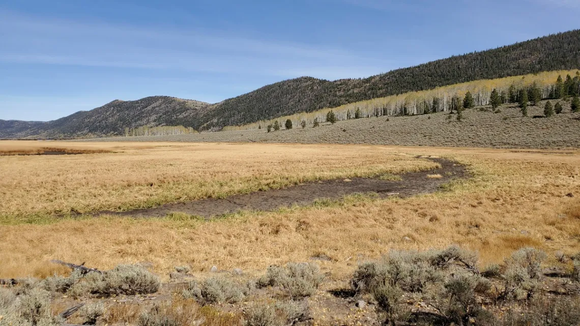
Is Pando in the Great Basin or not?
Have been looking at spots around the southwest trying to understand what is within the Great Basin, which is delimited by the Great Basin Divide. An article on the Great Basin is planned for October.
Zooming in on a topo map it appears that further up the ridge left in the first picture is the Divide! Waters west go to the Sevier River in the Great Basin and are stuck. Waters here go from Fish Lake to the Fremont River as mentioned in the above picture's caption.
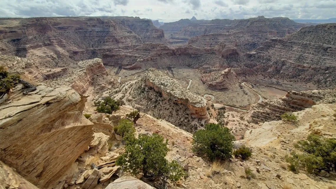
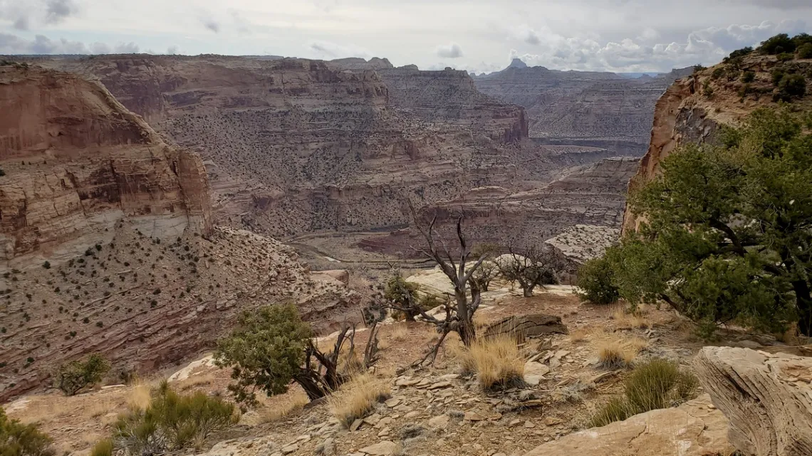
The "Little Grand Canyon" in the San Rafael Swell, southeastern Utah
About ninety miles northeast of Pando is the San Rafael Swell. Basic info about the Swell was provided in the September 2022 issue, with pictures from a couple hikes in the south section. Went back to the Swell a second time in March 2021 and got the picture below in the north section.
This is called the Little Grand Canyon, though there are places with that nickname in other states. That is the San Rafael River winding around below, heading for it's merger with the Green River 42 straight-line miles southeast.
Good Water Canyon Rim trail!
A page at UtahMountainBiking.com (with map) says "this is one of the best rides in Utah". The double loop is 21 miles total including the 15 miles along both sides of the rim, and a bit of Wedge Overlook Road on the west side and a county road on the east side. The trail meets the latter at the north end of Good Water Canyon (halfway around), so if hiking could do the whole thing in two day hike loops with camping at the head of Good Water.
The pictures below are from the Rim Trail. The first one gives a big picture, but wish the weather had been more clear. The second is about a 1/2 mi hike NE of the first picture's spot.
There is a large pile of other spots to visit/hikes to do in the Swell; a page at RoadTripRyan.com is a good reference.
by Kevin Hartley, Sierra Club Life MemberFrom the e-Mailbag
From time-to-time, the Alamo Group receives messages concerning local environmental issues. If you have thoughts on any of these issues, send us a message and we'll forward it to the writer.
The views and opinions expressed here are those of the authors individually and do not reflect the views or opinions of the Alamo Group or its members.
Environment threatened by wastewater
Hello! I am a resident of Guadalupe County and I reside in Seguin.
We have been given notice that our neighbor will be allowed to spray 172,000 gallons of human domestic septage on his property annually. The land sits over Wilcox Aquifer and is also in a FEMA floodplain. This will adversely affect not only our quality of life, but our ground water, natural grassland and wildlife.
I have gone to TCEQ and have gotten no where. I have spoken with our local commissioner and he is saying our hands are tied.
Can you help? Is there anything we can do to stop this?
Background information from August meeting
Editior's note: Our August General Meeting featured Stephen Lucke from Gardopia Gardens. He has provided this additional information about his references and upcoming events.
- https://docs.google.com/document/d/12XNkSbbkgWyaeAY6D1G28PY5ZmlXLDQYo2T1C_Zewxo/edit?pli=1
- https://docs.google.com/document/d/1IVKqTunQFR9ZPm6X6zHW6K3l5VEox-gJybCzS47J9x4/edit
- https://www.google.com/search?sca_esv=557296444&rlz=1C1GCEA_enUS990US990&q=tree+trunk+protectors&tbm=isch&source=lnms&sa=X&ved=2ahUKEwj88qT9-d-AAxWelWoFHa1uA14Q0pQJegQIDxAB&biw=1280&bih=603&dpr=1.5#imgrc=lExaKqM0hBXoRM
- https://www.abc.net.au/gardening/how-to/food-forest-fundamentals/12726464
- https://www.ipcc.ch/report/ar6/wg3/downloads/report/IPCC_AR6_WGIII_FullReport.pdf
- https://americas.uli.org/wp-content/uploads/ULI-Documents/Agrihoods-Final.pdf
- https://americas.uli.org/research/centers-initiatives/building-healthy-places-initiative/food-real-estate/
- https://storymaps.arcgis.com/stories/341621004abc4195b272da63a2f2cda2
Dates
- Saturdays @Gardopia (9a - 11a)
- 8/30 @City Council Chambers (5p - 6p)
- 9/9 @YWLA Primary (9a - 12p)
- 9/23 - Farmers Market @ Gardopia (4p - 7p)
- 10/27 - Garden Awards Gala
Outings: The Call of the Wild
Visit the Alamo Sierra Club Outings page on Meetup for detailed information about all of our upcoming Sierra Club Outings.
The Alamo Sierran Newsletter
Richard Alles, Editor
Published by the Alamo Group of the Sierra Club, P.O. Box 6443, San Antonio, TX 78209, AlamoSierraClub.org.
The Alamo Group is one of 13 regional groups within the Lone Star Chapter of the Sierra Club.
Changed your contact information?
If you're not sure whether the Sierra Club has your current email address, send an email to Member Services with your name and address and/or member ID (see Locating Your Member ID) so they can add your email address to your member record.
Have you moved? Let us know by sending your old address, your new address and your member ID to: address.changes@sierraclub.org.
Go online for the latest news and events
 |