CPS Energy’s Clean Energy Target is Not Consistent with Our Climate Goals
In order to limit warming to 1.5 degrees Celsius and avert the worst effects of climate change (such as heat waves more intense than last summer’s), the IPCC tells us that we need to achieve net zero carbon emissions by 2050. CPS Energy’s commitment to become carbon neutral by 2050 is not consistent with this target.
The IPCC’s target applies to all sectors of our economy, some of which will be more difficult to decarbonize than others. For example, zero-carbon jet fuel is currently 3-4 times more expensive than conventional fuel and is not expected to play a significant role in reducing aviation emissions until the 2040s at the earliest.
In contrast, electricity generation is easy to decarbonize. We already have the technologies we need---wind, solar, and storage---and green electricity is already cheaper than dirty electricity in much of the US. We need to decarbonize electricity generation first to buy ourselves time to develop and scale the technologies needed to decarbonize other sectors. This is why President Biden has set a nationwide goal of 100% clean electricity by 2035.
This past October, the Sierra Club released a report analyzing the climate pledges of 50 American utility companies. CPS Energy received a score of 40%, corresponding to a C grade, in part because of its plans to keep operating gas plants. Let’s pressure CPS to instead invest in green electricity, as this will save us money in the long term, avoid the health risks associated with natural gas, and support our decarbonization goals.
by Sam Greene, postdoctoral researcher at the University of Texas at AustinTrying to Make the Best Use of the Space Occupied by an Urban Freeway
In December 2023, National Public Radio had a story about Hunter's Field Playground in New Orleans, Louisiana, which is underneath an elevated section of Interstate 10, locally known as Claiborne Expressway. The playground is over nine years old, but it is in good shape because children do not play there. It is too noisy and unpleasant of an environment.
Motor vehicles, after all, produce noise, water, soil, and air pollution. Several studies have found that people living, working and going to school near such facilities are statistically less healthy. California banned new-school construction on land within 500 feet of freeways in 2003. As done elsewhere, the City of San Antonio’s Office of Sustainability discourages motor vehicle idling near schools.
Clearly, encouraging people, especially children, to gather and engage in physical exercise under a freeway overpass is not a good idea from a public health perspective. Physical exercise increases the volume of inhaled air, so “…it is crucial to avoid exercising in places with a high concentration of air pollution (i.e. near to a high traffic road).” A careful, detailed study of pedestrians aged 60 years and older found that, while walking had positive cardiopulmonary effects, walking along a busy street with high levels of air pollution eliminated these benefits.
But, land in the core of a city is a valuable asset, so what can be done to capture this community value? The Congress for the New Urbanism (CNU) has had some success in the promotion of the conversion of urban highways to more community- and environmentally-friendly boulevards. Bandera Road (SH 16) in Leon Valley and San Antonio may soon be a local example.
For urban residents, highways have a “barrier effect” from the “…delay, risk, noise and air pollution exposure that motor vehicle travel imposes on walkers and bicyclists, which degrades nonmotorized travel conditions, reduces active travel, and causes travelers to shift to less preferred modes, which tends to increase user and external costs such as traffic congestion, road and parking facility costs and pollution emissions.”
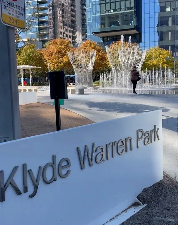
In 2023, the federal government established a new Reconnecting Communities Pilot Program intended to reduce the impact of urban freeways on urban neighborhoods by, in part, reducing the barrier effect. An approach to this is to depress the highway and put a walkable cap or lid on it. Klyde Warren Park in Dallas may be one of the best examples of such a cap.
When I moved to the Dallas-Fort Worth area in 1973, Dallas leaders had recently finished a lengthy campaign to get the new Woodhall Rogers freeway built as a depressed highway. This two-mile stretch of road was intended to connect Interstate 35 with North Central Expressway and Interstate 45 and thereby complete a freeway loop around downtown Dallas. A common urban freeway network design strategy is to provide a loop around a central business district to make sure every downtown destination can be accessed by highway. Unfortunately, this type of freeway loop can be an obstacle to close-in neighborhoods connecting with downtown. Dallas leaders did not want to cut off near northside Dallas neighborhoods from downtown.
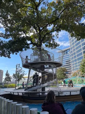
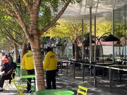
On a visit to Dallas in 2023 – 50 years after my first visit – I explored the “rooms” of the 5 acre park Klyde Warren Park and was totally impressed with how this freeway footprint was transformed into the most popular park in Dallas with the obvious positive economic impact of the surrounding area. Pedestrians, cyclists, motorists, and transit users – including riders of the heritage streetcars of the McKinney Avenue Trolley - can easily cross the freeway using the cap.
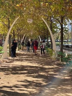
This urban oasis includes 37 native plant species and 322 trees. A Federal Reserve Bank of Atlanta economist concluded that “…the Klyde Warren Park lid over the freeway in downtown Dallas made the city a more attractive place to live and work.”
The motor vehicle emissions are still there, of course. They are confined to the roadway “tunnel”. Another National Public Radio story in October 2023 included a discussion of the air quality impacts of a cap built as part of the expansion of I-70 in Denver. Unsurprisingly, air quality is worse at the edge of the cap overlooking the highway and better in the center of the park built on the cap.
A report from the Tufts University Community Assessment pf Freeway Exposure and Health partnership found evidence that moderate reductions (<40%) in air pollution are observed in areas adjacent to freeway decks.
I keep thinking that something like Klyde Warren Park over a depressed I-37 at Commerce Street in downtown San Antonio would stimulate an amazing transformation of this area!
by Bill Barker, FAICP, FITE, Alamo Group Executive Committee memberIntroduction to the Great Springs Project
Our January General Meeting features Bill Barker, FAICP, FITE, Regional Transportation Planning Director – Great Springs Project, introducing us to the Great Springs Project, a corridor of protected lands between San Antonio and Austin.
Tuesday, February 20th
6:00 pm
Meeting schedule
| Informal get-to-know-you | 6:00 pm to 6:15 pm |
| Announcements | 6:15 pm to 6:30 pm |
| Featured program | 6:30 pm to 8:00 pm |
Venue
This meeting will not be webcast on Zoom. Attend in-person at:
William R. Sinkin Eco Centro, 1802 North Main Avenue
Map
Program topic
The Great Springs Project is creating a national park-scale corridor of protected lands between San Antonio and Austin over the Edwards Aquifer recharge and contributing zones. In addition, the four major springs in the corridor are being connected with an active transportation trail network from the Alamo to the Capitol.
Timely completion is important. As one of the fastest growing regions in the U.S., development is rapidly filling in the remaining open spaces between San Antonio and Austin. But, progress is being made due to the many public and private partners engaged in, or supporting, the effort.
This presentation will provide an overview of the Great Springs Project and how it relates to the rapid spread of impervious land cover threatening water supplies, wildlife, flooding, and open space. An update on the current progress will be provided.
About our speaker
Bill Barker has been advising Great Springs Project since 2019. He has served in the City of San Antonio’s Office of Sustainability, as VIA Metropolitan Transit’s Planning Director, as Executive Director of Solar San Antonio, and as an adjunct urban transportation and sustainability professor at UTSA and Trinity University.
As a consultant, Bill has helped public and private clients in seven states, Canada, and Mexico as well as the U.S. Departments of Energy and Transportation along with the Agency for International Development. He has been engaged in “think tank” projects with the UTSA Center for Urban and Regional Planning Research, Houston Advanced Research Center, the Environmental Defense Fund, the Center for Urban Transportation, and the National Academy of Sciences’ Transportation Research Board.
He also worked on the Apollo Program for NASA’s Manned Spacecraft Center in Houston. Bill is the only professional that is recognized as a Fellow by both the Institute of Transportation Engineers and the American Institute of Certified Planners. He has a B.S. in physics and a M.A. in urban affairs.
Contact: barker@greatspringsproject.org | 210-376-0776
The Alamo Group of the Sierra Club holds its general meetings the 3rd Tuesday of most months. They're always free and open to the public. View videos of our past meetings on our YouTube channel or our Facebook page.
The City Nature Challenge 2024
The Alamo Group plans on participating in a great worldwide naturalist event, City Nature Challenge 2024, which is staged on iNaturalist. See the City Nature Challenge website for information.
The iNaturalist app on a cellphone is an excellent tool to identify the plants and animals observed on an outing. With good cellphone photos the app gives in order the best fitting species of flora or fauna. Observation can also be made with digital cameras and added to the iNaturalist website. Both types of observations are on a website to be reviewed and confirmed by other observers including curators. Once confirmed as research grade they form a database that can be used by biological scientists for many purposes.
The outings program of the Alamo Group will incorporate training for this wonderful tool in naturalist outings this spring. This will be a great opportunity for participants to better learn the plants, birds butterflies, insects, spiders, and other fauna of the area. Another reward of becoming a regular iNaturalist observer is the development of iNaturalist friends. Users can become followers of other observers and help confirm their observations and vice versa. Outings together can follow.
The City Nature Challenge 2024 is an event staged by iNaturalist on April 26 through April 29 where observers in Metro areas around the world submit observations. These observations help document the state of biodiversity in the world. Part of the format is competition between Metropolitan Areas for the most observations and most species observed. This competition helps recruit new observers to iNaturalist who in turn can help document the diversity and distribution of species worldwide.
The San Antonio Metro Area has competed for 5 years in City Nature Challenge with increased observations each year. We barely passed the Austin Metro Area in observations and were at less than half those of Dallas-Ft Worth and Houston-Galveston in 2023. A Challenge Team for the San Antonio Metro Area has put together an organizational effort to greatly increase the number of observers and observations.
Registration, training, observational events, internal competition, and awards for participation are included in the website. One of the internal competitions on the site is between teams that are formed.
The Alamo Group would like to put together teams that pair our experienced iNaturalist observers with less experienced or novice observers. If interested in being a member of an Alamo Group team, you can contact Jerry Morrisey at jlmorrisey@aol.com.
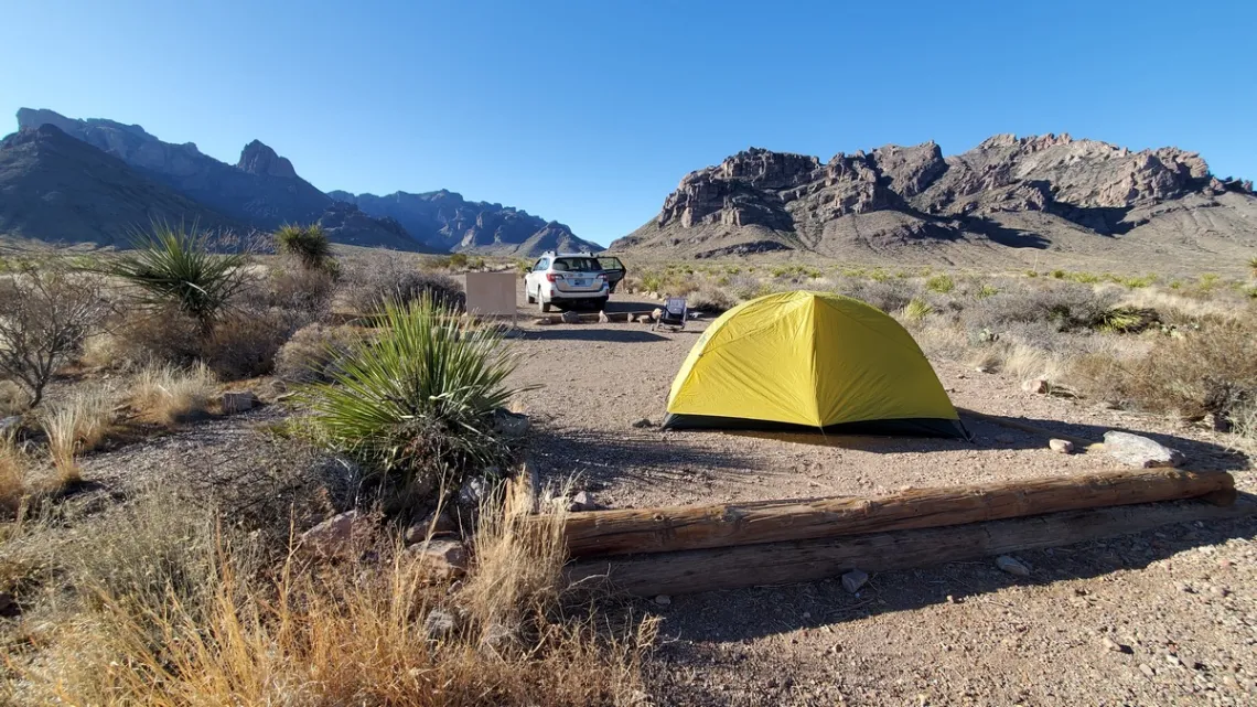
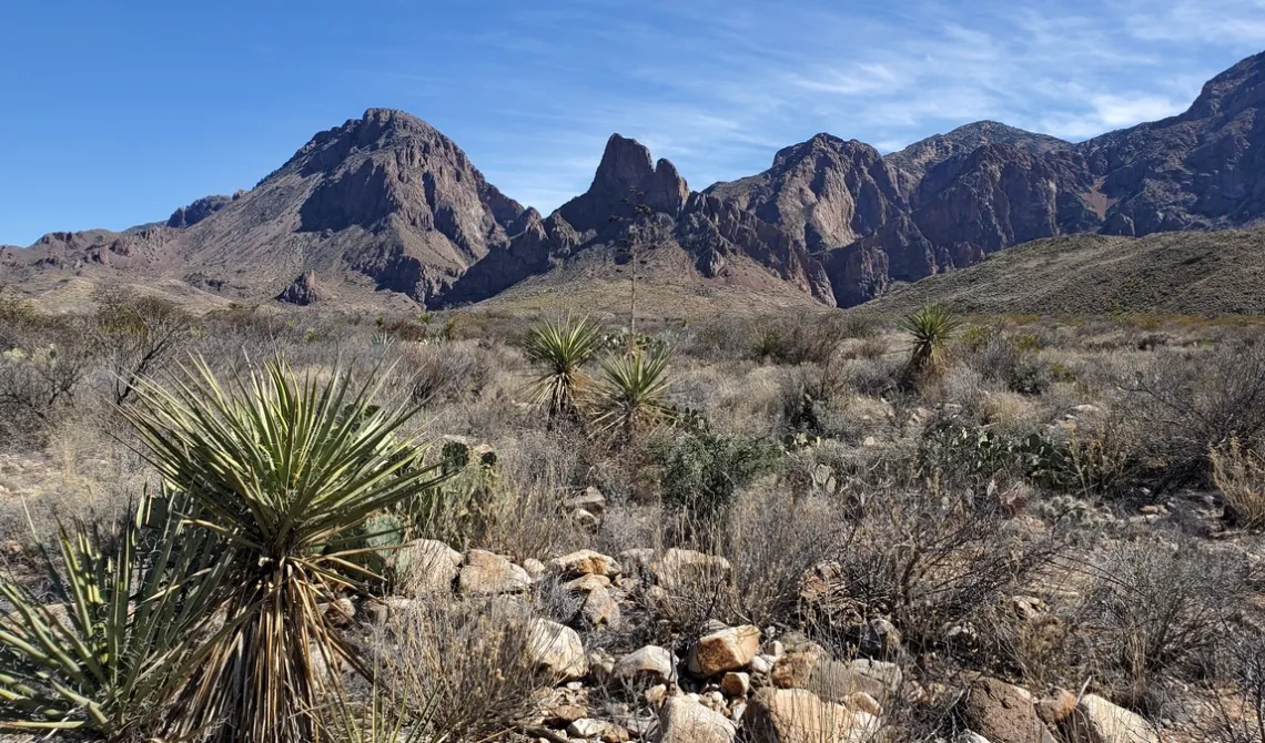
by Jerry Morrisey, City Nature Challenge 2024 Team MemberBig Bend National Park: a Couple Spots Not Often Visited and a Book, Death In Big Bend by Laurence Parent
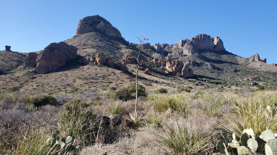
The most popular places in the park include Chisos Basin, the Rio Grande Village area and Lost Mine trail. A few alternatives are Pine Canyon, Oak Creek and Cattail Falls.
Pine Canyon
The turnoff south from Rio Grande Village road is 5.5 miles southeast from the visitor center. Then Pine Canyon road goes west 6 miles to campsite #5. Site #1 looked easily reachable for RVs and one was there. Some high clearance spots along the road but not bad.
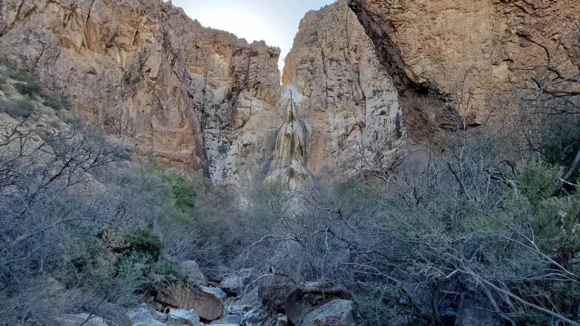
Pine Canyon Trail is 2 miles one way, gains 1000' to base of Pine Canyon Falls. Here's the park page and another with good pictures. There is a sign somewhere about there having been a ranch up the canyon, presumably due to the water from the falls and likely a spring, though didn't see any remnants of a ranch.
On the way back looked at the appealing low-angle hikes to ridges just north; geez only a mile or whatever each way, surely grand vistas, though would have to dodge lots of prickly vegetation. For example, the third picture.
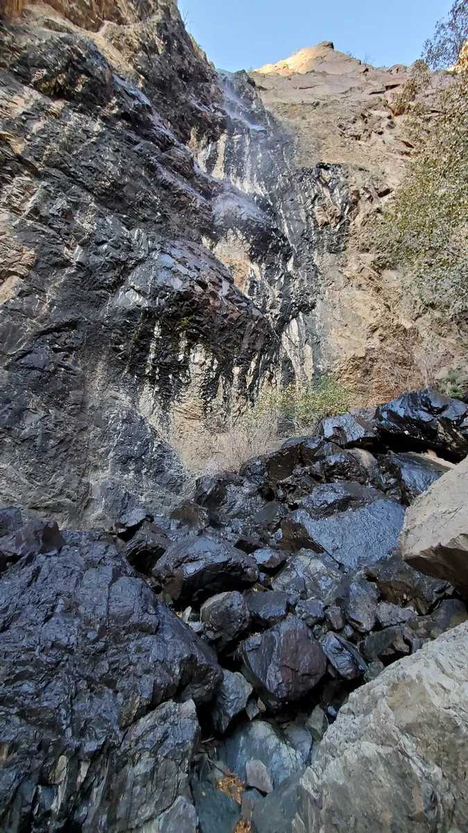
Oak Creek and Cattail Falls
We can do the Window trail from the Chisos Basin campground west to the Window, then down Oak Creek trail to Ross Maxwell road, 5.2 miles total. Have a buddy promise to pick us up at the road a few hours later. AmericanSouthwest.net has a good page with map and pictures.
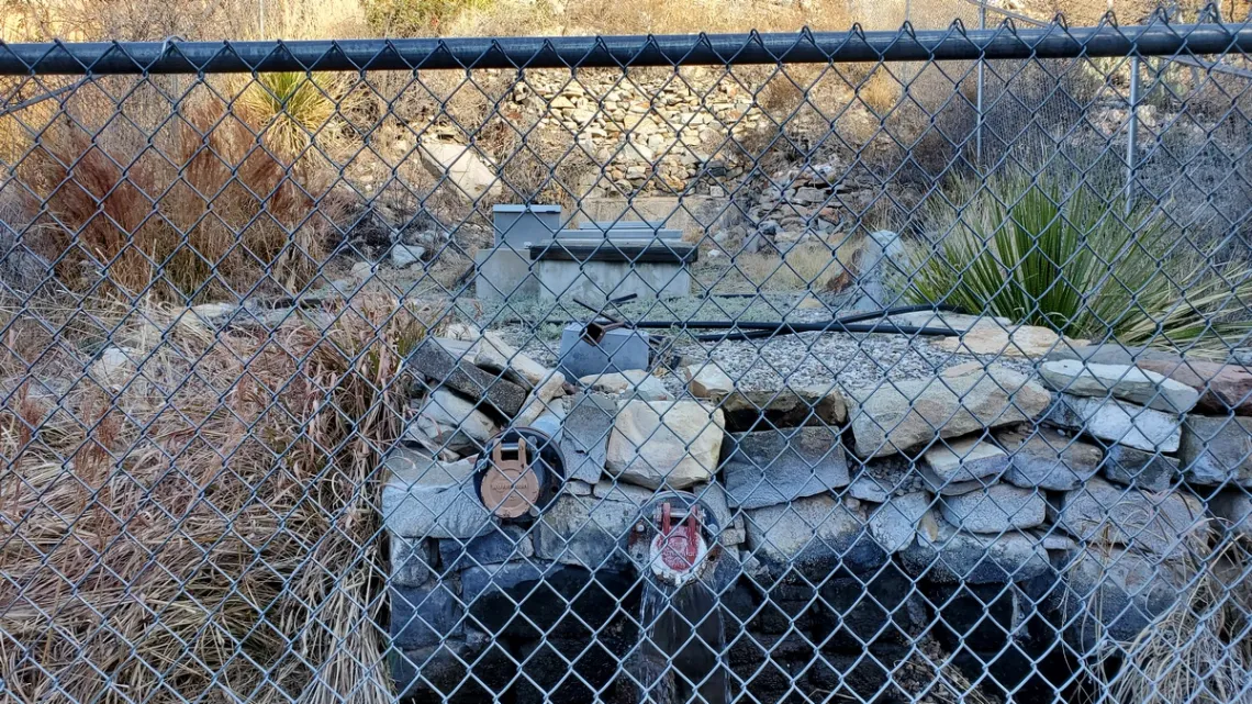
Much of the water used in the Chisos Basin for the lodge, cottages, dining room and visitor center comes from a pump at bottom of Oak Creek (3rd pic below) via a pipeline up through the Window. So the supply is strictly limited particularly during droughts. I got a message years ago asking for input regards water restrictions in the Basin. I replied that all hose bibs should be spring-loaded, all showerheads and faucets low flow and toilets ultra-low flush. And informational signs pleading for water conservation everywhere. We can refill containers at the north entrance station and Panther Junction for use in the Basin.
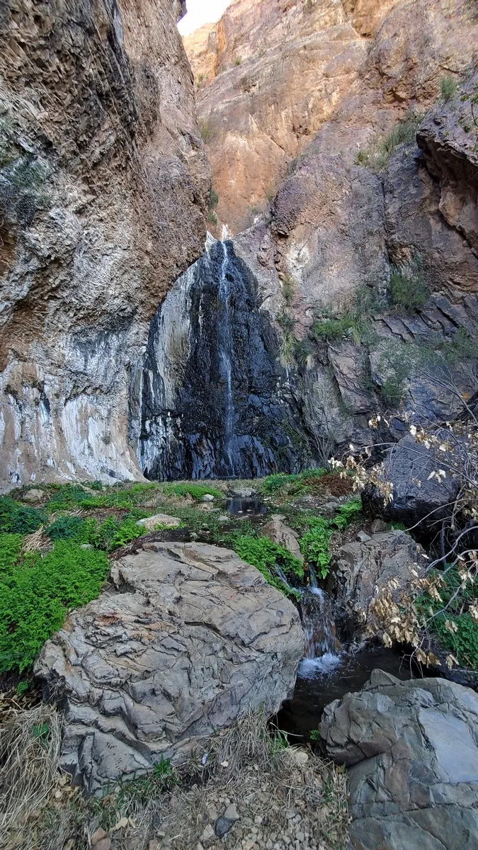
Hiking up from Ross Maxwell road we can visit Oak Creek a bit and then visit Cattail Falls. The junction for the trail to the latter, heading south then east, is clearly signed though this destination is not shown on park maps. I've read on a few websites that the park is trying to limit traffic to Cattail Falls due to this spot being ecologically fragile. If we visit let's stay on the trail, not touch the vegetation and stay out of the pool.
Death In Big Bend — True Stories of Death and Rescue in Big Bend National Park
This is a book by Laurence Parent, published 2010. Seventeen stories. Forward by a former park ranger and appreciative acknowledgment of staff assistance with park files.
Very educational stories, some of which ring bells for us as we remember doing that road or trail. Though not the route described below I'm sure.
The chapter titled Bryan Brock is about the death of a climber by that name during an attempt to descend the sequence of high falls ending with Cattail Falls (last picture). This was in December 1984.
Two buddies, experienced and strong, started out down the route from Laguna Meadows above the Basin with 80 lb packs including 765' of rope and technical gear. One rope was 600', so doubled for retrieval below that allows descent something less than 300' max. One pouroff is said to be 435', required tying in the second rope.
One guy got down finally with the assistance of the other above, though was getting hypothermic due to being in a waterfall. The other guy get stuck and died hanging in a waterfall. The first guy had desperately hiked out for assistance but it was too late.
From the e-Mailbag
From time-to-time, the Alamo Group receives messages concerning local environmental issues. If you have thoughts on any of these issues, send us a message and we'll forward it to the writer. The views and opinions expressed here are those of the individual authors and do not represent the views or opinions of the Alamo Group or its members.
Security and sustainability forum
This morning I attended a Webinar "Recalibrating Our Economic Compass: Embracing Circularity for a Healthy Planet” presented by the Sustainability Forum. It is one of a series, and is magnificent. I would like to publicize this series to Sierra Club members.
This session contrasted the linear (consumer-to-garbage) economic model with the circular model where products are designed so that resources are re-used. So many good ideas, such as the rather radical suggestion to tax materials (consumption; finite) rather than labor (potentially infinite). And to sell services rather than goods, such as renting washing machines rather than selling them (the company therefore is incentivized to use most durable products that require least maintenance); the consumer becomes a user.
Underying concept: we are guardians of resources (and Earth), rather than owners with no responsibility to future generations or other members of community/world. So obvious when stated clearly and without moralizing. The three invited speakers were all European, and they gave examples of how these ideas are being implemented there. Refreshing!
The webinar was recorded, and the archive of past Security and Sustainability Forum webinars is at www.ssfworld.org.
submitted by Joan C.
Outings: The Call of the Wild
Visit the Alamo Sierra Club Outings page on Meetup for detailed information about all of our upcoming Sierra Club Outings.
The Alamo Sierran Newsletter
Richard Alles, Editor
Published by the Alamo Group of the Sierra Club, P.O. Box 6443, San Antonio, TX 78209, AlamoSierraClub.org.
The Alamo Group is one of 13 regional groups within the Lone Star Chapter of the Sierra Club.
Changed your contact information?
If you're not sure whether the Sierra Club has your current email address, send an email to Member Services with your name and address and/or member ID (see Locating Your Member ID) so they can add your email address to your member record.
Have you moved? Let us know by sending your old address, your new address and your member ID to: address.changes@sierraclub.org.
Go online for the latest news and events
 |