Our group is dedicated to defending and restoring local natural environments while leading advocacy work within the Moreno Valley, Riverside, and surrounding areas on the following topics:
Protect the San Jacinto Wildlife Area.
The San Jacinto Valley in Southern California is the floodplain of the San Jacinto River in western Riverside County. The first native people settled in the San Jacinto Valley thousands of years ago. Later, the Maara’yam (or Serrano) and the Ivilyuqaletem (or Cahuilla) people arrived. Their villages were located along and near streams and springs. They were hunters and gatherers and they subsisted primarily on small game and acorns. The Soboba Indian Reservation, just east of San Jacinto, is now the home to the descendants of some of these people. More than a century ago, much of the Valley was colonized for agriculture, and the farming communities of San Jacinto, Hemet, Nuevo, and Lakeview were founded. For the most part, urbanization has not spread north of the Ramona Expressway.
With the development of Los Angeles, an aqueduct was constructed in the 1930s to transport water. The aqueduct depleted most of the water resources within the ranch and adjacent lands, and by 1938 most all of the water was gone. Because of the water loss, the lands were mostly leased out for cattle grazing until 1960, when they were converted into a facility for testing rocket propulsion systems. Rocket-testing activities ceased in 1974, and the land was kept vacant to retain the option of continued rocket testing. In the years following, grazing and farming was allowed on parts of the land, and the rest was left for fallow succession. All farming operations ceased when it was determined that the Stephens' Kangaroo Rat (SKR) was present on the ranch lands, primarily within the designated and utilized farming areas. However, grazing throughout the ranch remained in operation.

The Stephens’ Kangaroo Rat is a small-sized nocturnal rodent adapted for warm and arid conditions. Stephens’ kangaroo rats (SKR) primarily eat seeds, and collect seeds and other materials in exterior cheek folds lined with fur. SKR hop on two hind feet, and require open habitat on gentle slopes for efficient movement. SKR also use their hind limbs to excavate sufficiently deep burrows which provide shelter from predators, areas for nesting or food storage, and protection from most fires and other surface disturbances. By removing and redistributing seeds, SKR can act as keystone species in their habitat. Stephens’ kangaroo rats are known to occur in western Riverside County, western and central San Diego County. The SKR remains a threatened species to this day according to the US Fish & Wildlife Service.
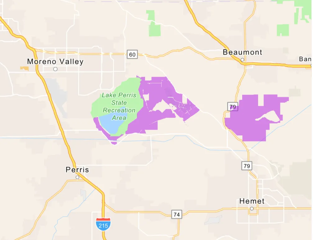
Today, the San Jacinto Wildlife Area (SJWA) covers approximately 19,000 acres, including 900 acres of restored wetlands. The area’s western boundary is adjacent to the 8,800-acre Lake Perris State Recreation Area. The SJWA, with its combination of wetlands, uncultivated grasslands and alkali flats, dairies and cropland, remains a mecca for grassland species and birds.

Due to the abundance of wildlife, the area was once considered a sportsman's paradise. Families and friends would often visit the area for vacation and social gatherings. Recognition of these lands as a valuable resource has led to their preservation. In 1979, CDFW, Department of Water Resources, and the Metropolitan Water District of Southern California executed a Memorandum of Agreement for the mitigation of the State Water Project's (SWP) wildlife losses in southern California. The mitigation actions were implemented pursuant to the Davis - Dowling Act of 1961, which includes the preservation and enhancement of wildlife and public recreation as purposes of the SWP. The agreement designated existing SWP lands for wildlife mitigation and provided funding for land acquisition, both of which contributed to the establishment of the San Jacinto Wildlife Area. In recognition of the region's value, the SJWA was established in 1979 to preserve upland and wetland habitats and provide public hunting areas
The property was designated as a wildlife area by the Fish and Game Commission in 1982. In the following years, areas within the Wildlife Area have been altered to enhance and enlarge wetland habitats for conservation and for native animal species.
The Box Springs Group has been on the forefront of defending this sensitive land area since our formation around 1990. Back then, the Moreno Highlands Project was proposing to develop 7,600 houses next to the SJWA. The SJWA has been under constant threat due to development by corporations and the nearby municipal authorities.
In 2001, the National Audubon Society recognized the northern San Jacinto Valley as an Important Bird Area (IBA) of Global Concern, based on scientific criteria. The IBA includes the SJWA, much of the northern San Jacinto Valley, Lake Perris, part of the Badlands to the east, portions of the Lakeview and Bernasconi Hills, and a discontiguous riparian woodland along San Timeteo Creek. Recently, thousands of new homes have been proposed immediately to the south of the SJWA, and millions of square feet of warehouses are proposed immediately to the north. These developments are a direct threat to the Valley’s bird life. In response to these and other threats, in 2013 the National Audubon Society recognized the San Jacinto Valley IBA as warranting special attention and protection. Five of the twenty-four Priority Species for North America are found here: Black-necked Stilt, Long-billed Curlew, Swainson’s Hawk, Tricolored Blackbird, and Western Sandpiper. This designation means that there are initial signs of population decline and enough potential threats to warrant a close watch on their status. By protecting birds, we are also safeguarding America’s great natural heritage for future generations, preserving our shared quality of life and fostering a healthier environment.
We owe credit and our sincerest gratitude to the following people and organizations for their information used in this explanation:
“A Brief History Of The Sierra Club San Gorgonio Chapter” by Alice Krueper & Sierra Club (1992)
History From The City Of San Jacinto
Overview & History From The State Of California, Department of Fish & Wildlife
Environmental Conservation Online System, U.S. Fish & Wildlife Service
Assist in the preservation of local trails, open-spaces, hilltops, and natural skylines.
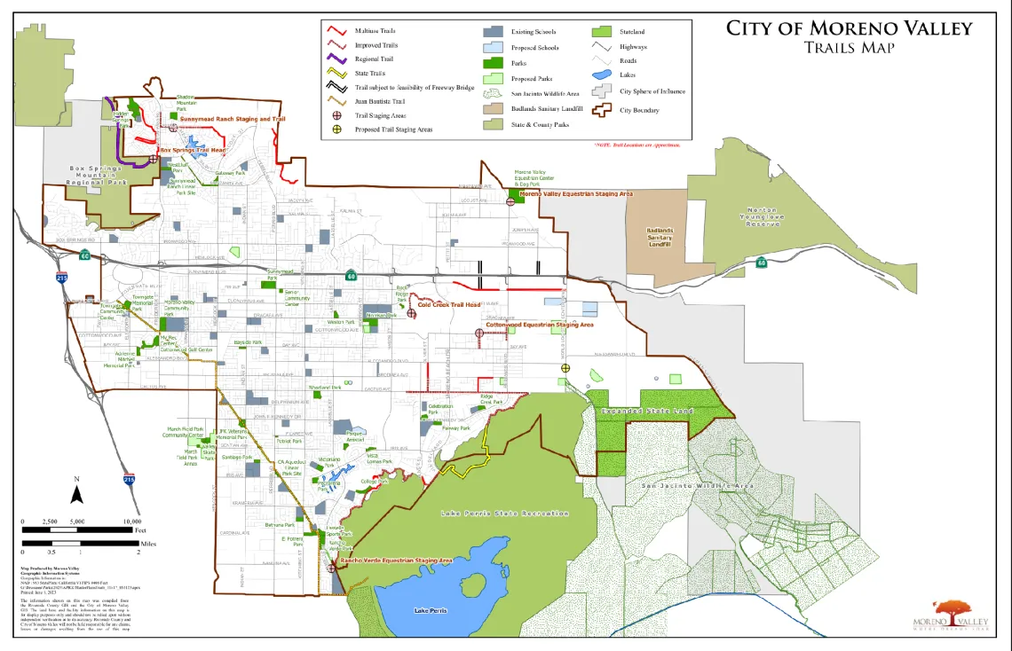
Moreno Valley maintains and operates 36 parks, trails and facilities including a golf course, sports fields, senior center, skate parks, equestrian center and community centers. The city is also home to the 8,000-acre Lake Perris State Park. This state park has boating, fishing and camping facilities. Moreno Valley’s Master Plan of Trails connects neighborhoods, parks, and regional destinations like Lake Perris and Box Springs Regional Park, offering 56+ miles of scenic paths for walking, jogging, biking, and horseback riding.

Riverside boasts over 31 miles of multipurpose trails distributed throughout the community and available for all levels of ability. They feature a variety of paved and unpaved offerings catering to the city’s walking, hiking, biking, and equestrian communities. The City of Riverside’s Park System includes almost 3,000 acres of park land, consisting of 49 developed parks, 6 natural or wilderness parks and 7 undeveloped future park sites.
Riverside County’s Box Springs Mountain Park, located off Pigeon Pass Road, encompasses 1,155 acres and provides trails for hiking and horseback riding.
Riverside County has over 40,000 acres of open spaces, parks, and wildlife habitat.
We owe credit and our sincerest gratitude to the following people and organizations for their information used in this explanation:
Moreno Valley: Parks, Trails, & Facilitates
Riverside: Trails Master Plan 2030
Riverside: Park & Facility Map
Riverside County Regional Park & Open Space District: Recreational Open-Space Areas
Inform and advocate on behalf of residents and our environment on local land-use, transportation, and air-quality issues.
California Government Code Section 65300 requires each city and county in California to adopt a General Plan “for the physical development of the county or city, and any land outside its boundaries which...bears relation to its planning.”
General Plans can be considered a city’s development constitution, containing both a statement of the community’s vision of its long-term development as well as the policies to support that vision by guiding the physical growth of the city.
California grants local authorities power over land use decisions. As a result, cities have considerable flexibility in preparing their general plans as long as State requirements are met. The California Government Code establishes both the content of general plans and rules for their adoption and subsequent amendment. Together, State law and judicial decisions establish three overall guidelines for general plans; General Plans should be: Comprehensive, Internally Consistent, & Long Range. The General Plan covers all the elements required under State law—land use, circulation, conservation, open space, safety, noise, housing, and environmental justice—as well as three additional topics of local importance to the community—economic development, community character, and health.
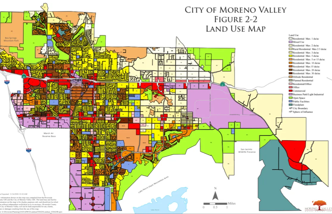
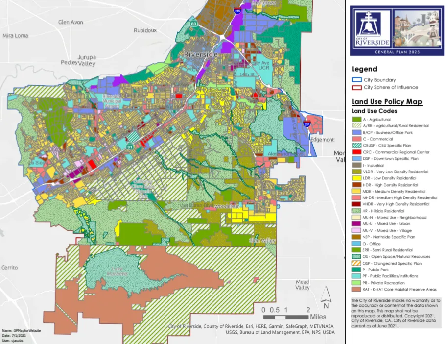
Land use is a framework of designated residential, commercial, industrial, and open space zones designed to balance growth, manage development intensity, and separate incompatible uses.
A General Plan Amendment (GPA) is an official, legislative change to a city or county's long-range, comprehensive land use policy document. It alters map designations or policy text, allowing for changes in development density, intensity, or land use type. GPAs are often necessary for major development projects, land use changes, or policy updates.
This is where many problems with environmental justice and irresponsible development begins. This early, technical, obscure stage is often underestimated or overlooked entirely by the majority of the public. It is at this point where cities and counties are able to rezone and reshape the future of their jurisdictions on a generational timescale. The most unfortunate instances involve land designated for residential, parks, open spaces, agriculture, and even commercial being lost to industrial uses which in itself opens the possibility of cascading environmental impacts on the surrounding areas.
Once an area is zoned for industrial, the surrounding communities can expect development projects that involve but are not limited to manufacturing, processing, storage, distribution, power plants, steel mills, mining, and oil refineries. These facilities and industries typically increase traffic congestion, infrastructure degradation, energy consumption, noise, pollution of all kinds, public health risks, and waste among other effects. Due to this output of impacts, cities and counties usually put themselves in an unfortunate circumstance because rezoning to industrial leads to a negative feedback loop where the only conclusion of what to build nextdoor is more industrial.
Cities have jurisdiction over their territory however unincorporated areas are managed by the county. This can pose an additional layer of inequity because these smaller populated areas may face even larger areas of neighboring land to be rezoned to industrial use by a small governing body that can be miles upon miles away with little to no representation for opposition.
Warehouses are not standalone buildings; they take in goods and move them out again – mostly with trucks, which burn fuel and clog up streets and highways. The 4,000 warehouses that line the region’s transportation corridors generate some 600,000 truck trips every day, producing a staggering 50 million pounds of carbon dioxide.
The implications for climate change and personal health are daunting. In just one year, from 2019 to 2020, the number of unhealthy air days in San Bernardino County jumped from 15% of the calendar to 20% of all days. And, predictably, the negative effects of that pollution and related traffic congestion are overwhelmingly concentrated in neighborhoods inhabited mostly by Latinos and low-income residents.
With a population of just over 200,000 people, Fontana houses distribution centers for Coca-Cola, Target, Smart & Final and FedEx, among others. Since 2010, Fontana has approved more than 70 new warehouses, which cover some 860 acres and produce more than 16,000 truck trips a day.
San Bernardino and Riverside Counties continuously rank first and second respectively for the worst ozone pollution in the United States. The two counties also ranked in the top ten for the worst annual particle pollution nationally, according to the annual State of the Air Report by the American Lung Association.
We owe credit and our sincerest gratitude to the following people and organizations for their information used in this explanation:
Inform and oppose the adverse effects of irresponsible development.
Every Californian should have the opportunity to live in a community that is healthy and safe. This is especially true for low-income communities and communities of color, who suffer disproportionate exposure to pollution and the resulting health impacts. In February 2018, the Bureau of Environmental Justice was established in California, and in April 2021, Attorney General Bonta announced the expansion of the Bureau. The Bureau is comprised of attorneys who are solely focused on fighting environmental injustices throughout the state of California and uplifting the voices of frontline communities who are all too often under-resourced and overburdened. Many of these communities are referred to as “disadvantaged communities” under state law.
Under state law: “environmental justice” means the fair treatment of people of all races, cultures, and incomes with respect to the development, adoption, implementation, and enforcement of environmental laws, regulations, and policies.
The Bureau of Environmental Justice works to: ensure compliance with state and federal environmental laws in all communities; investigate and bring enforcement actions that hold polluters accountable for illegal contamination of air and water in communities already overburdened with pollution; take actions to eliminate or reduce disproportionate exposures to lead and other toxins; protect the unique rights of Native American communities; and challenge the federal government’s actions that inadequately protect public health and illegally roll back environmental protections for all Californians.
If you have information to share regarding environmental justice issues in your community, please reach out to ej@doj.ca.gov.
Environmental racism is central component of environmental injustice. According to Dr. Benjamin Chavis, “environmental racism is racial discrimination in environmental policy making and the enforcement of regulations and laws, the deliberate targeting of people of color communities for toxic waste facilities, the official sanctioning of the life-threatening presence of poisons and pollutants in our communities, and the history of excluding people of color from the leadership of the environmental movement.”
Today, numerous EJ organizations, grassroots groups, and activists continue to fight against the disproportionate ways that environmental issues impact low-income communities of color. These efforts continue to expand to capture a more intersectional view of how various issues including housing insecurity, economic injustice, and fashion waste all contribute to disproportionate environmental impacts on low-income communities of color.
Environmental Justice, State of California Office of the Attorney General
Challenge all local logistic and distribution warehouses, AI data centers, and negligent developments; especially those in communities with heavy environmental justice disparities.
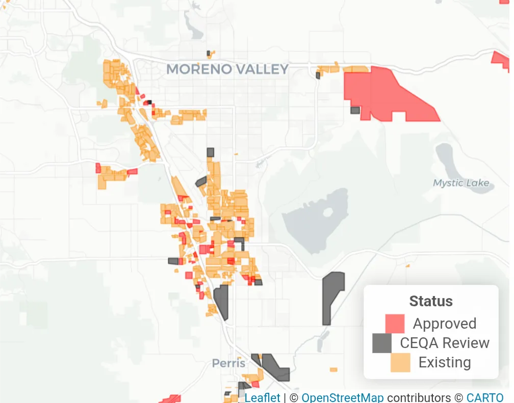
Today, warehouses occupy about 1 billion square feet of the Inland Empire. Another 170 million square feet has either been approved and is awaiting construction, or is pending approval from a local government.
In 1980, the region was home to 234 warehouses; there are now more than 4,000. And individual warehouses are getting bigger, too. Nearly 40 square miles of the region’s land today sit beneath the roof of a warehouse.
In just one year, from 2019 to 2020, the number of unhealthy air days in San Bernardino County jumped from 15% of the calendar to 20% of all days. And, predictably, the negative effects of that pollution and related traffic congestion are overwhelmingly concentrated in neighborhoods inhabited mostly by Latinos and low-income residents.
The growth in warehouses is in part a reflection of changes in the national and international economy. Indeed, most of the goods that pass through these warehouses are not bound for the Inland Empire at all. It’s merely a waystation for everything from pharmaceuticals to toys, arriving from Asia and making their way to points east of Fontana or San Bernardino.
The phenomenon also reveals holes in the region’s approach to planning. Warehouses typically are approved by local officials, often with little consideration for their impact on neighbors even though the cumulative effect of the new warehouses is regional rather than localized (pollution and traffic don’t stop at a city’s edge). But calls for regional planning test the Inland Empire’s politics and its structure, leading to confusing, uncoordinated policy decisions.
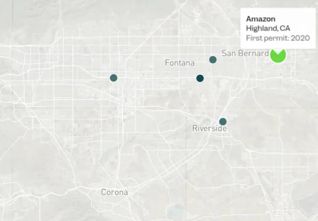
In June 2025, Business Insider found 1,240 data centers in America already built or approved for construction at the end of 2024 — the most comprehensive tally to date. 5 being in the Inland Empire.
Data centers are massive facilities that power cloud computing and our digital infrastructure, which are rapidly expanding across the United States. Once concentrated in a few regions, data center development has surged nationwide in recent years. The increasing demand for computing power, fueled by artificial intelligence and cryptocurrency, is placing unprecedented strain on the energy grid, land, water resources, and health of local communities.
Utilities are being pushed to build new power plants, often fueled by fossil fuels, to serve these facilities’ around-the-clock electricity needs. Without strong safeguards, households and small businesses could be left paying for costly infrastructure while communities face worsening air pollution, water stress, and land-use conflicts.
"See where data centers are across the US on our interactive map" Business Insider