By Tom Douglas
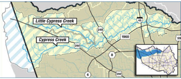
Cypress Creek arises near the border between Harris County and Waller County, flows across northern Harris County, and merges with Spring Creek near Interstate 69/US Highway 59.

Map of the Cypress Creek Watershed provided by Harris County Flood Control District
You may well have hiked down to the creek at one of the many parks, such as Jesse H. Jones Park & Nature Center, Herman Little Park, Mercer Botanic Gardens, Kickerillo-Mischer Preserve, or Bud Hadfield Park. Or, perhaps you have canoed or kayaked part of the Cypress Creek Paddle Trail on a Sierra Club outing.
Unfortunately, Cypress Creek does not currently meet the Texas Surface Water Quality Standard for contact recreation. It is classified as being impaired with respect to fecal bacteria, and there are additional concerns for nitrate, total phosphorus, depressed dissolved oxygen, and habitat for aquatic life.
To address these problems, especially the one with bacteria, the Cypress Creek Watershed Partnership has been formed. The Partnership is tasked with organizing background data from the field, bringing together computer modeling with stakeholders’ local knowledge, weighing the probable effects of future changes in patterns of land use, and coming up with science-based, practical solutions in the form of a Cypress Creek Watershed Protection Plan. Your participation is genuinely invited. Please check out the Partnership’s website for more about how you can get involved.
On July 23, 2019, the first organizational meeting for the Partnership was held in Cypress (western watershed) during the afternoon and in Spring (eastern watershed) during the evening. Participants were provided with background information, given an opportunity to indicate particular problem spots on maps, and asked to make suggestions for membership in the Partnership’s Steering Committee.
The second meeting took place in Spring on September 26, 2019. The 11-member Steering Committee was selected based on nominations made since the first meeting. Members of the Steering Committee came from diverse backgrounds: Agriculture, Business/Development, Community, Conservation, Forestry, Hydrology, Local Government, and Residents. Preliminary plans were made for a series of specialized Work Groups that will report their findings at the Partnership’s third general meeting, slated for November 21. Tentative areas to be addressed by these groups are: (1) Human Waste and Stormwater; (2) Agriculture, Wildlife, and Invasives; and (3) Hydrology. Existing data from monitoring stations located on Cypress Creek and its tributaries have been used to construct Load Duration Curves, which provide guidance regarding how large the reductions in bacteria levels will need to be for each part of the watershed to meet the standard. The next step will be computer modeling, which will combine field data, where available, with literature values and quantitative assumptions based on previous studies. Likely sources of fecal waste to be included in the models include humans, pets, livestock, wildlife, and invasive species such as feral hogs. Stakeholder feedback will be crucial for refining these preliminary estimates. The results of revised modeling and recommendations from the Work Groups will be presented at the third general meeting of the Partnership. Please join us on Thursday November 21 from 5:30 to 7:30 PM in the Barbara Bush Library, 6817 Cypresswood Drive, Spring, TX. All are warmly invited.