Comments from the Chair
Politics
1) Local elections
Election runoffs for San Antonio City Council are in early voting now, May 30th to June 6th, with full election day Saturday June 10th. Please check out our endorsements for local elections via our website TurnTexasGreen.org. Please help our candidates win, and please vote! We have a real chance to turn San Antonio government green.
2) Texas legislature
The regular session ends the last day of May, so by the time you read this it will be all over. Check out our story, The 85th Texas Legislature: Assessing the Highs and (Mostly) Lows, below. In addition, our Lone Star Chapter will be posting a post-mortem with analysis of the good, bad and really awful on its Legislature page.
3) Washington
The list of environmental assaults lengthens almost by the day. Check any of your favorite environmental news sources, especially the Sierra Club, for details.
National Sierra Club elections
Board of Directors elections were successful. Most importantly, voter turn out was sufficient to provide valid results.
Climate action
We will continue to press for action on climate change. I strongly hope we get our endorsed candidates as Mayor and City Council members this month so we can get some progress again.
by Terry Burns, M.D., Alamo Group Chair
Rapid Transit Corridors

Come join us at our June General Meeting to hear from VIA Metropolitan Transit regarding their ongoing Rapid Transit Corridor Studies.
Tuesday, June 20th
6:30 p.m.
William R. Sinkin Eco Centro, 1802 North Main Avenue
Map
The VIA Vision 2040 Long Range Plan identified key areas of opportunity, or Rapid Transit Corridors, where transit reliability improvements can improve our region’s transportation choices. VIA has begun to study four Rapid Transit Corridors, including:
- Southeast Corridor – connecting Brooks City Base, the Pearl, and Downtown San Antonio
- East-West Corridor – connecting Lackland Air Force Base, Our Lady of the Lake University, Downtown San Antonio; and the AT&T Center;
- Northwest Corridor – connecting UTSA, the South Texas Medical Center, Balcones Heights, and Downtown San Antonio; and
- North-Central Corridor -connecting Stone Oak, the San Antonio International Airport, San Antonio College, and Downtown San Antonio. The Rapid Transit Corridor
Studies will work to better understand who the transit system is serving, the infrastructure we have to work with, and how people are choosing to get around. With that information and continued community conversations, the Rapid Transit Corridor Studies will look at many options to improve reliability, assess each option’s benefits and costs, and make a recommendation of improvements to bring rapid transit to the region.
The 85th Texas Legislature: Assessing the Highs and (Mostly) Lows
Following is a summary of outcomes on the limited universe of bills that I was following this session.
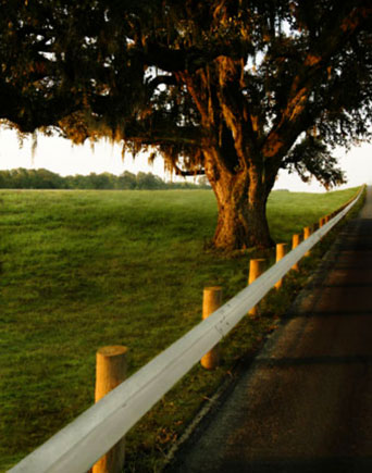
Anti-tree bills
Homebuilders got legislation reducing the amount of mitigation required to compensate for excessive tree removal. They have tried unsuccessfully since 2009 to axe tree preservation rules, and finally achieved their goal this session. Fortunately, Senator Lois Kolkhorst (R-Brenham), the sponsor, worked with stakeholders to moderate the bill's negative effects.
Encouragingly, four radical bills that would have gutted tree preservation rules and allowed clearcutting of development sites failed to even get committee hearings. There's more about the deal that led to this in our May newsletter.
Finally on the anti-tree front, a bill allowing landowners to cut down any trees they “believe” pose a fire risk got out of committee but ran out of time before its vote on the House floor.
Edwards Aquifer-related legislation
Sadly, a good bill prohibiting direct discharge of sewage effluent into waterways that recharge the Edwards Aquifer ran out of time before its House floor vote.
Another good bill, establishing a biennial study and report on the use of green stormwater infrastructure and low impact development in Texas, was voted down in the House.
A bad bill, that would have forced cities to buy conservation easements from developers who, because of impervious cover limits, must leave part of their land undeveloped, never got out of committee.
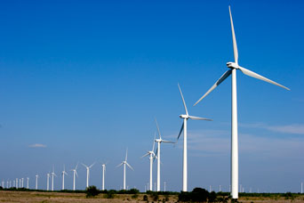
Wind energy
An anti-wind bill preventing wind farms from receiving tax breaks if they are within 25 miles of certain military airfields has cleared a Senate/House conference committee and will soon be on Abbott’s desk.
Deregulation
There were several bills filed to increase developers’ grandfathering out of local environmental regulations. Fortunately none of them passed. Note that Texas already has the most developer-friendly grandfathering laws in the nation.
In a welcome and unexpected reversal of fortune, an anti-annexation bill was killed by an 11th hour filibuster by Senator José Menéndez (D-San Antonio). It would have limited cities' ability to extend the geographic reach of environmental rules, such as tree and groundwater protection ordinances.
Governance
A bill by local rep Lyle Larson to end Governor Abbott’s pay-for-play system of appointments passed the House but never got a vote in the cowardly Senate.
In a related action, Abbott’s appointee to the TX Parks and Wildlife Commission, Kelcy Warren, was confirmed by the Senate. Warren is the billionaire CEO of Energy Transfer Partners who is building the notorious Dakota Access pipeline and another through the Big Bend region.
Recycling
A good bill establishing a statewide household battery recycling program never made it out of committee.
Ending with positive news, a bill to prevent cities from banning single-use plastic bags at stores went down in defeat.
by Richard Alles, Forests/Trees contact, May 29, 2017
A Plastic Ocean

This month, our Lions Field event is a screening of the feature length documentary A Plastic Ocean.
Thursday, June 22nd
6:30 p.m.
Lions Field Adult Center, 2809 Broadway @ Mulberry
Use VIA bus route 9 or 10
Map
In this film, two explorers set out on a four-year global journey to learn about the devastating crisis of ocean plastic that has polluted our waterways, choked aquatic life, and could spell major consequences for human health. Their journey is accompanied by engineers, scientists, and conservationists. This event is free and open to the public.
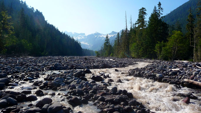
Wonderland Trail: Best Backpacking Loop in the Continental US?
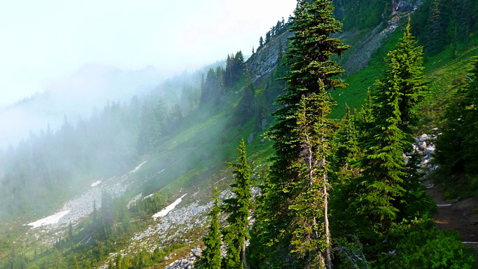
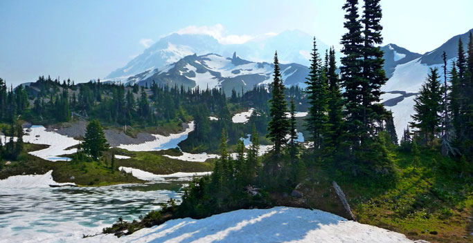
The Wonderland Trail around Mount Rainier is 93 miles long, gaining and losing over 20,000' elevation. This elevation change results from hiking in and out of the numerous river valleys (in the southwest we would call them canyons) that originate from the glaciers pouring down the sides of Rainier, the most glaciated peak in the northwest.
There are amazing river crossings (see the North Puyallup picture below) and views of a few glaciers, even with the serious recession due to global warming. Nearly every step exposes more spectacular scenery. Wildflowers abound into August.
The whole loop is usually hiked in 10 to 12 days. The trail segments are well maintained, with no real exposure or serious challenges, other than early or late blizzards and ice/snow accumulations. Here's the Mount Rainier National Park website. The backcountry trip planner and map shows the roads, trails and campsites.
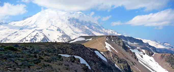
Rainier (originally known to Native Americans as Tacoma or Tahoma), is the fifth highest peak in the continental US at 14,411', (though only 84' lower than the highest, Mt Whitney). And, one of the most dangerous active volcanoes in the world. The entire Puyallup River Valley would be threatened by lahar flows from an eruption, including Tacoma and Seattle. Here's the Wikipedia article. The last real eruption was in 1854 but there has been minor activity since, though the volcano is now thought to be asleep — at least for the short term.
Visiting
The park requires a backcountry permit for use of the Wonderland Trail campsites, and this is strictly enforced due to the high demand. Here's the park wilderness permit page. These permits are getting very hard to come by; there were a record number of requests for 2017.
The park manages cache dropoff/pickup locations along the route, so it should not be necessary to carry more than four days worth of food. Everywhere on the trail, water is usually within a few hours hike, but must be sanitized. A good plan is to start/end at Longmire in the southwest corner of the park, as that does not have backcountry campsites as do the other cache pickup points.
Temperatures are very pleasant July/August. Insects require serious repellent at a few particular campsites, especially earlier in the season. Rain and winds might be limited as for my trip August 2010, or much less likely could be severe!
The large Cougar Rock campground is located just east of Longmire. There is also a large campground at White River on the east side, and others elsewhere.
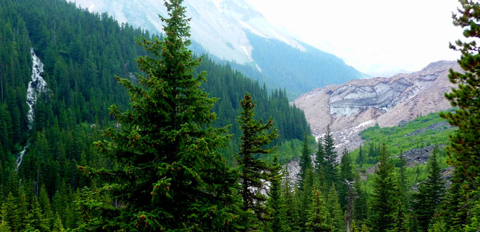
There are lots of trails accessible for dayhikes. You could hike most of the Wonderland via dayhikes with shuttles. In addition to dayhiking bits of the Wonderland itself there are great hikes including up Rainier from Paradise, across Burroughs Mtn from White River, the Naches Peak Loop Trail (including a little piece of the PCT), and some into the Tatoosh Range on the south side of the national park. The latter is probably not listed on the park's dayhike page due to being rather more challenging than the rest but here's a page at SummitPost.org.
Mt. St. Helens, which erupted in 1980, is just to the south of Mt. Rainer NP, in Gifford Pinchot National Forest. Here are another large pile of extremely scenic trails including the Loowit Trail, which circumnavigates the mountain.
My pictures above aren't technically very good; maybe I can do better this September as I have another permit, will do it again in twelve days with buddies. Plus some hikes in the Tatoosh Range, probably retracing some steps of my stepfather 75 years ago. So, maybe there will be an update of this article!
by Kevin Hartley, Alamo Group Outings leader
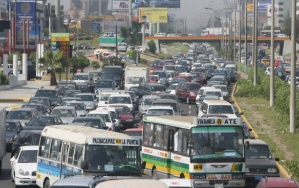
Chaos and Contamination
The good news is that today, DIGESA (General Office of Ambiental Health), announced that the level of air contamination in Lima had decreased 46% from the highs experienced in 2001. The bad news is that the air is twice as contaminated as it should be according to local regulations and the World Health Organization (WHO).
The study was made measuring microscopic particles in the air (PM 2.5) of lead, cadmium, copper, magnesium and other dangerous metals that can lead to illness and allergies. In 2016 the measurement was 26 micrograms/m3 (26 µg/m3), much lower than the 49 µg/m3 in 2001, although double the standard of 15 µg/m3.
The reason for the reduction in contamination is due to several factors, including the renovation of the fleet of cars in circulation with a massive infusion of new vehicles and the switch to natural gas on the part of the many taxis plying routes in the city. However in the last few years the level of contamination has remained stubbornly constant. Another measure of pollution, a larger particulate, PM 10, show levels still two times that permitted in several districts of the city.
Lima and the adjacent port are of Callao have a plan to combat contamination, although the next administration in power will probably ignore it. Almost half of the 12.5 tons of CO generated here annually is the product of vehicular emissions, so any plan has to consider this aspect, especially ridding the city of the most polluting cars, trucks and busses.
One part of the plan is mitigation, by increasing 10 square feet the area of green space per person. At that rate it would take 15 years for the city to reach WHO standards, as Lima has a deficit of 560 million square feet of green space and is the least green city in Latin America.
Even though newer vehicles run cleaner, the sheer increase in private cars is threatening contamination levels. There are approximately 2,800,000 cars in Lima. In 2008 there were 200,000 new cars purchased in Peru, most of which stayed in Lima, but in January of this year alone 20,000 new cars entered into circulation, a 20% increase. This surge in vehicle purchase is being driven by increased migration to Lima and a booming economy.
Since 2005 the economy has been hot, other than in 2008 when growth fell to 1% (in the USA it was - 0.3%). The 2009 GDP growth rate almost hit 10%. Because of a lack of planning and an adequate road infrastructure including traffic control, the result is total chaos and perpetual traffic jams. As a consequence cars run for far longer to get from point A to point B. It is frightening to extrapolate from these figures and project five or more years into the future.

There are important lessons here for San Antonio regarding uncontrolled sprawl and burgeoning populations. Obviously there are more resources available for road improvements, and hopefully mass transit, to reduce road congestion, but the density of personal cars with single occupancy in the metropolitan area points to moving further away from compliance with fresh air standards, which has been our reality since 2014.
by John B. Hertz, Green Buildings Leader, from Lima, Peru
Adopt the Sierra Club’s Water Management Plan, Not SAWS’
San Antonio Water System (SAWS) claims to invite public input about its Water Management Plan 2017, which could be approved by the SAWS Board as early as June 6. SAWS has not, however, been forthcoming about the substance of that WMP or any supporting evidence.
SAWS' plan
On its website, SAWS claims that it uses the following four guiding principles to update the 2012 plan:
1. Conservation
We identify conservation strategies to reduce per-person consumption by 30 percent between now and 2070. We are also committed to using leading edge technology for monitoring and reporting water loss.
2. New water projects
This is critical to meeting future population growth and reducing San Antonio’s dependence on the Edwards Aquifer. We’ve made great strides by adding the new H2Oaks Center desalination plant in southeast Bexar County, and the Vista Ridge pipeline will continue the trend toward diversification.
3. Regional water projects
By developing water supplies that can benefit multiple communities, costs are reduced and areas without the means to develop their own projects can benefit.
4. Innovative technology
Our innovative recycled water system and aquifer storage and recovery process both help maximize current water supplies.
Those are not principles; at best, they are goals and strategies for a business model that involves investing in huge amounts of water that San Antonio doesn’t really need so that SAWS could become a major purveyor of water to surrounding communities and so San Antonio’s business and real estate development can attract water-intensive industries. All that, while the heavy costs of the Vista Ridge pipeline and the new brackish desalination plant are borne by existing ratepayers!
The Sierra Club's plan
The Alamo Group of the Sierra Club has put forth a far more sustainable Water Management Plan that will make San Antonio far better prepared for future droughts. Unlike SAWS’ plan, the Sierra Club WMP puts resilience in the face of Climate Change as a primary goal. Read a summary of our WMP on our Water Management page.
Unlike SAWS’ plan, ours is based on real principles – fundamental truths that are a foundation for a whole chain of reasoning and planning. The first – and most important – three are:
- Water is essential for life and health; thus, water is a human right. Adequate amounts of water should be available to all city residents, regardless of ability to pay.
- Water is a public resource, not a commodity. Public policy must ensure the sustainability of safe water supplies for the benefit of all people and the natural environment.
- Water is a renewable resource, neither created nor destroyed. Public policy should prevent reliance on nonrenewable water (e.g., water withdrawn from an aquifer faster than the aquifer can recharge). There is no such thing as “new” water, so the water that we have should be used and reused carefully.
Conservation
SAWS claims to promote conservation, but its policy in the recent drought of record was to use water supplies to enable SAWS customers to avoid drought watering restrictions during the unprecedented stages III and IV drought in 2014. For more details about how SAWS new 2015 rate structure will actually reduce the bills of customers who would use so much water during a comparably severe drought in the future, see my essay Conservation, Not Growth, Should Guide Water Restrictions in the Rivard Report. San Antonio needs to learn from Melbourne, Australia, which experienced 13 years of severe drought.
Conserve first – What Melbourne did: Melbourne’s total per capita water use dropped approximately 50%, reaching a historic low and staying low long after the drought ended. Voluntary conservation and water efficiency measures reduced residential gpcd from about 79 to below 40. Detecting and fixing water system leaks reduced water loss from 9% before the drought to 5.4%.
What San Antonio could do: San Antonio is far ahead of most U.S. cities in water conservation, and SAWS’ Conservation Department is outstanding. However, the decision to promote San Antonio as a place of “abundant water” threatens to de-rail San Antonio’s water future. San Antonio could, with voluntary conservation, water efficiency measures, and fixing indoor leaks, reduce residential gpcd from 73 gpcd in 2015 to below 50 by 2025, at current rates of reduced usage, or - in case of severe drought - to 32 gpcd.
Detecting and fixing SAWS’ much greater system leaks (more than 11 billion gallons/year) could cut water loss by more than half. If SAWS’ leaks were reduced from 15% to to 7.5%, that alone would reduce the total gpcd from 118 to 109.
SAWS’ WMP is part of the problem with the SA Tomorrow plan, as it now stands. Without addressing water-related sustainability problems as soon as possible, San Antonio’s future resilience in the face of climate change will be greatly impaired.
Because CoSA (City of San Antonio) staff relied exclusively on SAWS’ flawed water management projections and representations about conservation, all of the water-related goals set for SA Tomorrow planning were unambitiously low (e.g., the per capita water overall usage goal was set at 110 gals/day by 2040 (instead of a do-able goal below 90).
New Water Projects: Vista Ridge pipeline should be abandoned altogether, and the desalination plant should be used only as needed. Instead of forcing SAWS ratepayers who are willing to conserve water to pay for such expensive water, SAWS rate-structure should make the residents and businesses that use the most water pay for the most expensive water.
The Sierra Club’s sustainable WMP calls for an integrated water collaborative that utilizes stormwater, wastewater, graywater, and decentralized rainwater harvesting to increase the city’s water supply by maximizing the use and reuse of the water that falls in our “City as Catchment”.
No Water Sales to Promote Unsustainable Growth: SAWS needs a whole new business model. It should not try to be a purveyor of water, but rather to provide services that meet our city’s needs. The kinds of growth that Vista Ridge would stimulate are completely wrong for this semi-arid region.
Innovative Technology is fine, so long as it is also environmentally sustainable. Technologies that are also energy-intensive are not the solution. The kinds of technologies our WMP promotes include rainwater harvesting, green infrastructure for dealing with stormwater to prevent flooding, Low Impact Development, and the kinds of city planning that provides water for growing local food and for irrigating the urban tree canopy to help keep us cooler in the face of climate change.
We urge everyone to read our “Water Management” page, which has lots of links to excellent examples in Melbourne, Los Angeles, and elsewhere. Then, contact your Council representative and be sure to vote for a Mayor and Councilperson who will firmly take responsibility for turning SAWS into the kind of water utility that San Antonio needs.
by Meredith McGuire, Co-Chair of the Alamo Group’s Conservation Committee

Outings: The Call of the Wild
Visit the Alamo Sierra Club Outings page on Meetup for detailed information about all of our upcoming Sierra Club Outings.
The Alamo Sierran Newsletter
Richard Alles, Editor
Published by The Alamo Group of the Sierra Club, P.O. Box 6443, San Antonio, TX 78209, AlamoSierraClub.org.
The Alamo Group is one of 13 regional groups within the Lone Star Chapter of the Sierra Club.
Keep your email address current!
Send updates to Loyd Cortez, providing your name, address and membership number (if known).
Changed your mailing address?
Have you moved? Let us know by sending your old address, your new address and your member number (look on the upper left corner of your mailing label) to: address.changes@sierraclub.org.
Go online for the latest news and events
 |