Since early human history, the vastness of the ocean has captured the intrigue of explorers, facilitated trade, and supported local economies. According to the National Oceanic and Atmospheric Administration (NOAA), our oceans cover 71 percent of Earth's surface, however it is estimated that humans have only explored as little as 5 percent (source). Despite how little is known about the ocean and its inhabitants, one thing is certain, sea levels are rising.
NOAA reports modern rates of sea level rise started as long ago as 1863, as evidenced by rudimentary tide gates (source). This change coincides with the start of the Industrial Revolution, when humans rapidly accelerated the burning of fossil fuels, leading to an increase in greenhouse gases released into the atmosphere.
We know seas are rising, but how? Respected climate organizations and government agencies have been researching the phenomenon for decades and have concluded that there are several different mechanisms that contribute greatly to global sea level rise.
What are the Primary Drivers of Sea Level Rise?
Thermal Expansion
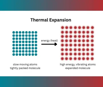
A primary driver for sea level rise is a scientific phenomenon known as thermal expansion. NASA estimates 90% of excess heat produced by greenhouse gases is absorbed by the ocean (source). As water molecules in the ocean warm, they expand. “Heat” is just energy, so the increased energy causes the individual particles of each molecule, atoms, to vibrate and move, making the once densely packed molecule expand. So, our seas are not rising just because there is more water, but because that water is occupying more space. Climate experts estimate this accounts for approximately one third of global sea level rise.
Ice Melt
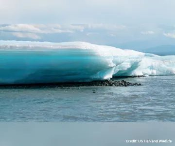
The most commonly understood driver of sea level rise is the melting of ice masses worldwide. The term “glacier” refers to large, slow-moving ice masses on land. Glaciers are categorized as “ice sheets” if they cover more than 20,000 square miles of land (source). The majority of Earth’s freshwater is captured in ice sheets. According to the Intergovernmental Panel on Climate Change (IPCC), ice melt from glaciers and ice sheets are the dominant contributor to rising sea levels (source).
Ice Sheets
The National Snow and Ice Data Center estimates that from 2002 - 2023, melt from Antarctica and Greenland’s ice sheets alone caused sea levels to rise 1.2 millimeters annually. On average, the two locations are estimated to add nearly 115 trillion gallons of freshwater to the ocean every year. That’s just larger than three times larger than Lake Tahoe, California’s largest lake. As human dependence on fossil fuels continues, the rate at which these ice sheets melt is expected to accelerate.
Glaciers
Although glaciers outside of ice sheets represent 1 percent of ice worldwide (source), they have a disproportionately dramatic effect on global sea level rise. NASA estimates that in the past century, glacial melt outside of ice sheets is responsible for 20 percent of sea level rise (source). This disproportionality is due to the locations of glaciers. They are commonly found in areas where the temperature is near that of water’s freezing point (32º F), making them more vulnerable to slight changes in temperature than ice sheets. The polar ice sheets experience colder temperatures, making the impact of a slight change in temperature less. Acting as a “canary in a coal mine”, glacial melt gives us a harrowing look at what the future may hold for polar ice masses.
Until recent years, sea level rise contributions from thermal expansion and ice melt were estimated to be around equal. Now, ice melt has overtaken thermal expansion and is the primary cause of rising sea levels. NOAA reports the Greenland ice sheet lost 34 billion tons of ice between 1992-2001, and 247 billion tons of ice between 2012 and 2016, a seven-fold increase. NOAA also reports that in the same time periods, ice loss in Antarctica quadrupled, and ice loss from glaciers quintupled. (source)
Groundwater Depletion
The final major contributor to rising sea levels is our usage of groundwater. USGS estimates half of the nation’s drinking water comes from underground aquifers. Without human intervention, this water would stay under the surface and remain “out of reach” of the water cycle. However, as human activity drains groundwater reservoirs, the water re-enters the water cycle and increases water in the ocean. NASA estimates that this depletion of underground freshwater accounts for 0.8 millimeters of sea level rise annually (source), which equates to roughly two Lake Tahoes added to the ocean each year.
Subsidence
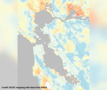
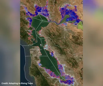
Not only is the sea rising, the land is also sinking. The ground beneath us is always moving, and this plays a part in how sea level rise impacts different coastlines. Vertical land movement (VLM) refers to the slight upward movement, uplift, and downward movement, subsidence, of the Earth’s surface. In coastal areas where subsidence is occurring, threats of sea level rise are magnified. The San Francisco Bay is experiencing some of the highest rates of subsidence on the West Coast. A new study by NASA found that coastal communities in the Bay, such as San Rafael, Corte Madera, Alameda and Foster City, are experiencing an annual subsidence rate of 0.4 inches (source). The researchers suspect this high rate is due to the use of landfill to build communities on the Bay. This factor suggests that sea level rise projections for the region may be significantly underestimating the impacts of sea level rise in the Bay.
How do we stop it?
There is no “solution” to sea level rise. Although reducing greenhouse gas emissions will lessen the severity of sea level rise, centuries of malpractice and abuse of natural resources has set in motion unstoppable geological and hydrological processes. Even if we stopped our emissions today, the sea would continue to rise for centuries before the Earth reached equilibrium status (source). Even then, forces such as subsidence would still result in an increase in coastal flooding. Instead of stopping sea level rise, communities must now assess how they can adapt to rising sea levels.
The San Francisco Bay Area, an epicenter for technological and scientific innovation, is now extending its global leadership to sea level rise adaptation. In 2024, the Bay Conservation and Development Commission (BCDC) approved the Regional Shoreline Adaptation Plan (RSAP), a novel and proactive playbook for shoreline communities around the Bay to follow as they plan to adapt to higher tides. Thanks to fervent community advocacy and collaboration with BCDC, the plan centers natural assets for shoreline resilience and vulnerable communities in the planning process.
The Sierra Club’s Bay Alive Campaign is actively engaged in local and regional efforts to advance natural and nature-based solutions, which leverage native ecosystems’ abilities to adapt to subtle changes in their environment in order to protect communities and critical shoreline assets. You can be a part of the campaign, volunteer today to keep the San Francisco Bay alive!