Los Angeles Reimagined
Bit by bit, nature is reclaiming the City of the Future
ON SOME DAYS, the Metro Gold Line train on its run toward East Los Angeles will take an informal extended pause—a ghost stop—between Lincoln Heights and Chinatown. Suspended momentarily over the concrete channel of the Los Angeles River, riders get an unexpected view of the water—its greenish stream along a 51-mile passage through sloped walls laced with elaborate graffiti. Vivid boxy letters float like clouds, and highly stylized tags claim territory or elicit warning. Surrounding the channel is a vast, ramshackle landscape, a stretch of century-old brick warehouses and large islands of open-air parking lots, hemmed in by the latticework of bridges and viaducts. The composite scene reveals layers of a city that at any given turn, depending on the viewer, tell a different story.
I'd taken that train countless times when, in 2005, I caught my first glimpse of yet another twist in this storied landscape. After that pause along the Metro route, the train lurched forward, moved past a gentle bend, and gathered speed. Then something unexpected came into view: a massive cornfield, sprouting up in the middle of rusting metal, broken concrete, and glass. The stretch of rogue, open, sparkling-green land seemed at odds with the city's not-so-distant looming skyscrapers and its seemingly endless sprawl.
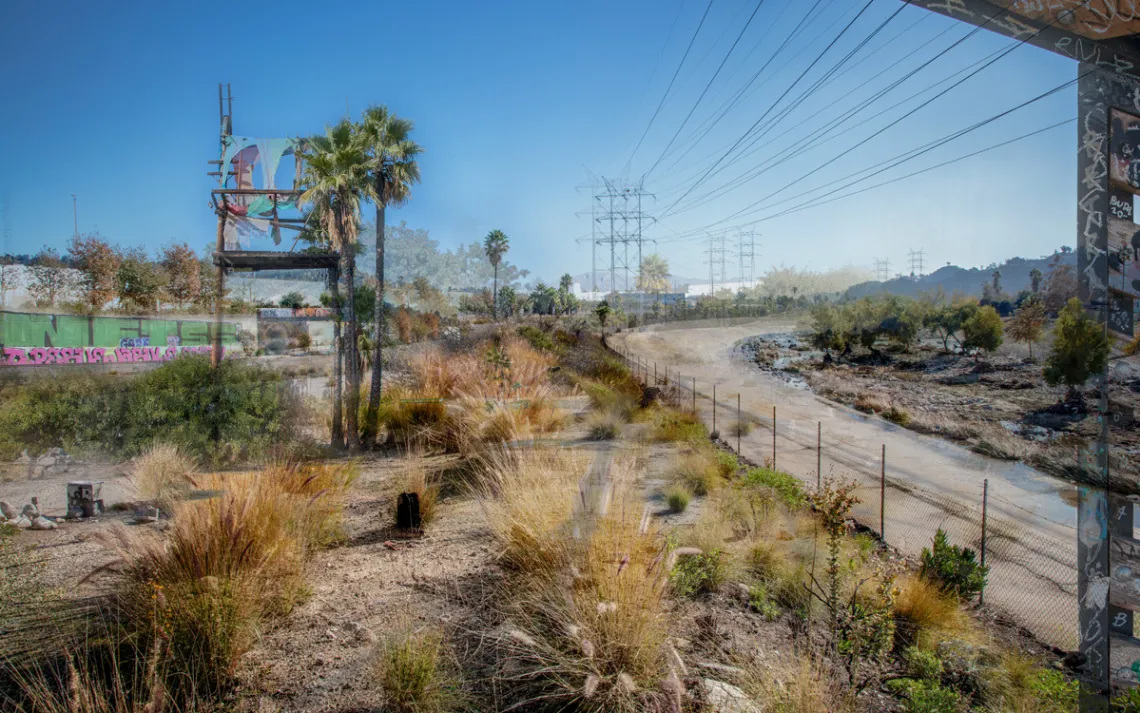
The cornfield turned out to be an ambitious installation by artist Lauren Bon. With Not a Cornfield, Bon intended to recall the tiered history of this land before it became "Los Angeles" while anticipating the arrival of a revitalized recreation space—Los Angeles State Historic Park. At that time, the site was a brownfield littered with debris and surrounded by aging warehouses and an abandoned railyard. In the 1990s, it had taken on the nickname "the cornfield" because, as the possibly apocryphal story went, corn had grown there generations before. As a nod to these yarns, Bon set out to turn the brownfield into a thriving green space, and for one season, her installation produced a full crop of corn.
In the weeks that followed, peering out from my murky Metro window, I'd take in the cornfield's meticulous evolution. What once seemed to be yet another layer of derelict Los Angeles was now shape-shifting, in chapters, into something magnificent. Open, fluid, wild—I could imagine myself in it. So often in LA, it's necessary to look twice—to make sure what you've happened into isn't just an apparition, a movie shoot, or a television backdrop. The fanciful crop of swaying cornstalks held a purpose. It was a declaration. Like the towering tags along the riverbank, it was marking place.
Over two decades, I've seen old government buildings left to crumble and decay behind razor wire and cautionary hazard signs. Blue-tarp and tent homeless encampments have bloomed and then been carted away. I've also observed another version of the city emerge from trash-strewn asphalt lots and fenced-in concrete dumping grounds, places that once were home to old sofas, fenders, and the occasional broken vending machine. Change abounds now in this place known as the City of the Future. Bit by bit, nature is taking Los Angeles back.
For more than 20 years, a community of deeply engaged residents, activists, artists, scientists, and culture workers has been reimagining what an urban and wild Los Angeles can be. The significance of that vision is more urgent than ever. The unique geography of Southern California makes it particularly vulnerable to the impacts of climate change—water scarcity, wildfires, rising seas, air pollution amplified by rising temperatures, flooding. Now Los Angeles, project by project, neighborhood by neighborhood, is a city at the vanguard of addressing the climate crisis by transforming public spaces into green spaces, replenishing native habitat, and preserving mature shade trees to increase the protective tree canopy. Many Angelenos have long advanced such notions for LA; today they have a better chance of succeeding, thanks to a push by the federal government.
Early in his administration, President Joe Biden issued an executive order establishing the America the Beautiful Initiative, which seeks in part to conserve at least 30 percent of US lands and waters by 2030. By identifying and rethinking the very concept of parks and natural areas, especially within urban centers, this initiative will help more Americans access and interact with nature. Among the goals for Los Angeles laid out in a 2019 mayoral plan: Double the amount of tree canopy in "areas of greatest need"; reduce the urban-rural temperature differential by at least 1.7°F by 2025 and 3°F by 2035; initiate the LA River Ecosystem Restoration project; and increase the public's proximity to parks and open areas. The region's residents—especially BIPOC communities, farmers, fishers, multigenerational families who have lived on and tended these lands but have often been excluded from the decision-making process around conservation, recreation, and landscape—are key to the success of the plan.
Meanwhile, many of LA's parks and open spaces are thriving, including Los Angeles State Historic Park; the nearby Bowtie Parcel, a strip of land abutting the LA River in Northeast LA; and the evolving Kenneth Hahn Park parcel located in the city's Westside. As paradigms of possibility and conservation, these parks also present Angelenos with an opportunity to at once safeguard place and tend civic memory.
The City of the Future has a chance to honor its promise of the past.
WHAT KIND OF SPACE—open or green—contributes tranquility or beauty to a neighborhood, along with the opportunity to connect and thrive?
"Getting to that deeper level, I always say, 'Let's think about space differently,'" says James Rojas, an urban planner, community activist, and artist who grew up in East LA. "The first step is to change people's perception of the possibilities on the nation's land. We will never have enough money to change everything, but that doesn't mean we can't see transformation."
Rojas is known for his leisurely walking tours and community-visioning workshops in which residents express their needs and desires for their neighborhoods. "We transform space as we move through it," he explains. Whether they're creating community-wide recreational areas or intimate neighborhood corridors, Angelenos, with their rituals and customs, reshape what exists—or hint at what's desired on a street-by-street level.
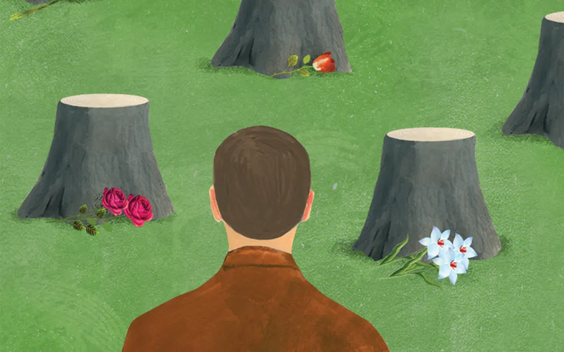
We wisecrack about it—the truth of the LA future we've inherited. What of those elaborate predictions for our futuristic metropolis? The reality of 21st-century Los Angeles may not have lived up to mid-20th-century magazine renderings of flying cars, jet packs, and sleek, multistory elevated concourses. Yet even though we live amid clusters of glass-and-steel high-rises, there has also been a remarkable grassroots effort to tunnel back to what was, or what could have been—an LA that honored and protected its open spaces, its flora and fauna in its natural state.
Part of reclaiming and revivifying Los Angeles—what it is at its very roots—is not simply about carving out space or revitalizing native habitat. It also requires understanding natural points of convergence—that metaphorical breathing space for recreation, strolling, meditation, convening across cultures, and creating alliances through them. It also requires understanding desire. As time has taught us, again and again, when designated gathering points don't exist, Angelenos make their place within and around what is there, personalizing it and then memorializing it when it's gone.
One such spot is the now-sealed Belmont Tunnel, a subway underpass formerly used by the Pacific Electric Railway's interurban streetcars between the 1920s and '50s. Located in the Westlake neighborhood, at the southern edge of Angelino Heights, the site (then known as the Hollywood Subway) was once the hub for the Pacific Electric Red Cars. After the last car rolled through in 1955, the complex—Toluca Yard—was shuttered. Over the years, the old substation was repurposed as storage for Cold War rations. Later, Westlake neighborhood residents adapted the site as a sports field for a pre-Columbian indigenous ball game, pelota tarasca, played across southern Mexico and El Salvador. Its participants, predominantly Mexican immigrants, converted the tunnel into a "stadium," drawing audiences from adjacent neighborhoods. In the 1980s and well into the '90s, the land also became an enticing outdoor clubhouse—a dynamic graffiti park, an all-hours gathering space and an ad hoc laboratory for young artists and musicians pulled there from communities across the LA Basin. In its kinetic chaos, that yard felt like a vital pulse, a portal into the spirit of a moment.
When the City of Los Angeles sealed the tunnel and granted permission to build a high-end apartment complex there, it brought that story to an end. Over and done. In a part of the city where several distinct communities intermeshed—Echo Park, Westlake, Angelino Heights, and downtown LA—the closure interrupted a story mid-thought. A story that was writing itself from the ground up.
IN 1930, THE OMSTED BROTHERS and Harland Bartholomew & Associates, a landscape architect and planning team, submitted an extensive report—Parks, Playgrounds, and Beaches for the Los Angeles Region—to the Los Angeles Chamber of Commerce. Three years and several field studies in the making, their report proposed a detailed system of parks and parkways, children's playgrounds, and public beaches to promote health and renewal and recreation. Greater Los Angeles had just gone through a building boom and was facing a Great Depression economy. There was time to correct the course.
Sophisticated and sweeping in its recommendations, the Olmsted-Bartholomew plan grappled with not only the physical size of Greater LA but also its infrastructure, amenities, and class strata. Additionally, the report examined the ways in which the region already lacked open space and how a systematic plan might rectify that—creating protected areas that the team identified as "untouchable reservations."
Even back in 1930, Los Angeles was sold on its possibility—its good bones, its fine features. And while overdevelopment and overuse were the key concerns of the report, it also pointed to environmental issues that could scar the region irrevocably. The Olmsted-Bartholomew plan highlighted the fact that efforts to protect park space were an investment in quality of life: "The benefit of parks bought now will accrue largely in future years and even to future generations," the authors affirmed.
None of it was implemented.
"The 1930s report is a window into a lost future," Mike Davis wrote in his 1998 book Ecology of Fear. "If their proposals had been implemented, the results would have been virtually revolutionary."
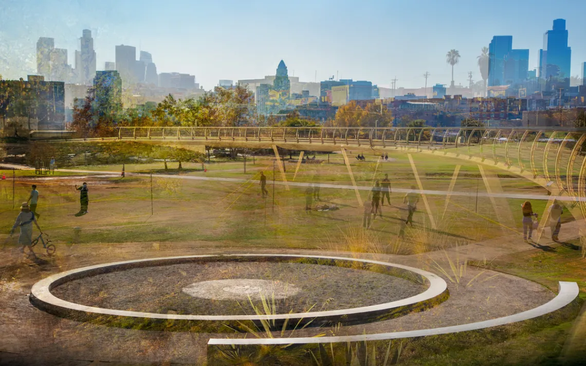
Ninety years after the report, bits and pieces of it are starting to bloom. On 32 acres, stretching alongside historic railroad ties, Los Angeles State Historic Park is a sparkling civic jewel, its terrain multifaceted and revealing. The big lawn is home to Frisbee tosses and soccer practice. The public orchard offers harvests of oranges for the picking. The placid, wooded area at the northmost end opens up to uninterrupted views of the San Gabriel Mountains, providing a site for conversation or solitude.
The park is a captivating example of what might have been. Three distinct yet discreetly demarcated areas unfold within its footprint to retell nested chapters of Los Angeles's chambered history, shedding light on the original people who made their lives here. After Southern Pacific abandoned this land in the 1990s, it moldered in plain sight. As the downtown grew, developers trained their sights on it. In 2001, after a protracted, emotional battle involving developers and a vocal and varied community coalition, the State of California purchased the land and designated it as a new park space. Making it so was a years-long process.
Along some of its rutted pathways—strewn with rock and with patches of the railroad's 19th-century paving stones peeking through—are a series of place-specific art installations. One sculpture, Origins: Los Angeles River 1815/1825, was created by artist Debra Scacco. The piece is composed of two large obelisks made of concrete, echoing the river's remade channel. Laced on its burnished-steel surface, Scacco's delicate hand-engraved etchings recall both the original and post-channeling paths of the river. Acknowledging the Indigenous Tongva, the people who first lived and worked on this land before the Spanish claimed sovereignty, Origins stands within the river's natural floodplain and within view of what was originally called the Zanja Madre, "mother ditch," "El Pueblo's" first aqueduct.
It feels nothing short of a miracle to walk along these paths and understand a sense of what the Tongva woke up to in the morning. The painterly views of the mountains, the chattering birdcalls. What siren song circled within the imagination of new settlers, generation after generation? Not just the etched lines of the mountain range against the sky but the sharp scents of laurel and sagebrush. The present-day vista also inspires a futile game of if only.
I lean in to marvel at Origins's feathery tracings of waterways. The reflective surface mirrors back a shadowy, blurred image. An impression of me.
Now, as I hoped all those years ago, I finally see myself here, in this place.
ACROSS THE BASIN, what we now see emerging adjacent to the old traces of the railroad, along the passage of the Los Angeles River, is beyond "beautification"—it is a recommitment to possibility. The intricate reclamation projects that have begun to take shape along the river owe a debt to the work of the Olmsted brothers and Harland Bartholomew. If not outright extensions or elegant nods, the projects at the very least are confirmations of what these designers so long ago dreamed could be.
William F. Deverell, a historian who has dug deeply into the Olmsted-Bartholomew vision, has been heartened by the developments. He sees echoes of its intentions when he takes students kayaking on the river. "The Olmsted-Bartholomew project had breadth, vision, and creativity going for it," he says. "But the client in the end said something like, 'Oh, we didn't mean for you to be that ambitious.'"
Organizations like Friends of the LA River have worked for decades to reconnect Angelenos with the river. In 1986, the organization's founder, poet Lewis MacAdams, famously brandished a pair of wire cutters and cut a passage through a portion of chain-link fence. Creating a jagged passageway, he declared it open to the public. This gesture gave birth to his decades-long initiative to "uncage" the river—unsheathing it from its cement jacket, restoring its riverbeds, its lush riparian habitat, mobilizing and educating Angelenos through high-profile public events at which MacAdams served as an ever-present booster, donning his signature porkpie or stingy brim fedora and affable smile.
At the Bowtie Parcel, along a trail near the asphalt north bank of the river, Julia Meltzer and I crunch along on a parallel course. Except for a freight train rattling past, it's surprisingly quiet. You wouldn't suspect that two major freeways loom just a couple of miles away. Meltzer and I are the only two people on the trail. There's just the hint of morning marine layer still present, making the light gentle, powdery. The cirrus clouds give the sky a canvaslike appearance. As we head east, we take in the activity on the "gentrified side," as most of my friends now call it. It's a stretch where you can get fancy coffee or solid sandwiches named after NPR personalities.
I make out brightly colored kayaks leaning against a fence and cafes with stacks of tables waiting to be set up for service. Couples and single riders whiz by on bikes and electric scooters. At the river's edge, on that side, there is an actual shore bank. Meltzer points out an egret, and we marvel not at its elegance but at the very fact that it is here. As city kids, both of us, it seems fitting that we are rooted on the side that is still ramshackle, still forming, tagged and imperfect. It's glorious and reminds me of the old Belmont Tunnel's scene lit up with parties and high jinks—a hideaway in open space.
Meltzer is the founding director of Clockshop, an arts and culture organization headquartered on a corner of the northeastern Los Angeles neighborhood of Elysian Valley, known to locals as Frogtown. Clockshop has hosted panels and cultural events in Elysian Valley as well as in Los Angeles State Historic Park. In May, Clockshop hosted its second-annual Community and Unity People's Kite Festival, an event that brought disparate neighbors together on the big lawn and honored the communities who fought to bring the park to fruition. Along this scabrous expanse of land, Meltzer commissioned art pieces—several of which still stand and have developed a lived-in patina. These are "projects that are temporary in nature and also bring awareness to what existed," Meltzer says.
While MacAdams's dream for the river was to free it from its concrete strictures, Meltzer recognizes that it may not be possible because of climate change. "Most of the time the river is dry. However, when it rains, it pours. In the case of a 100-year or 500-year flood event, the capacity of the channel will be challenged, and it will affect Frogtown dramatically. So my question is, What can we do to beautify and work with the channel as it is now?" She points to the examples of the Manzanares, a river in Madrid—which features a green space alongside playgrounds, gardens, and walking trails—and the popular San Antonio River Walk in Texas as thriving possibilities. With such a compromise, the site could honor a storied place, told in its distinct phases.
Officially a part of Rio de Los Angeles State Park, the Bowtie Parcel consists of 18 acres of land on this east bank. In 2014, Clockshop partnered with California State Parks to reimagine the landscape. Like the former cornfield, this stretch was once a busy, working railroad property called Taylor Yard, the headquarters of the Southern Pacific Railroad. Meltzer gestures toward a raised, wide concrete circle, emblazoned with vivid, billboard-size tags. Its center of river rock, wood, and weeds is studded with rusted spray-paint cans, beer cans, exhausted lighters, and other detritus—miniature delicate assemblage pieces made on the fly by late-night visitors. "People obviously gather here," Meltzer says. "It calls to people."
Even still, it's easy to imagine what if: From some places along the pathway, you can observe traces of the natural habitat, river water rushing over rocks. At one spot, if you look up, you'll see the Griffith Observatory standing watch. "We need to think about how you engage who is here now," Meltzer says. Along with recent arrivals, "there are families who have lived in these neighborhoods for generations who didn't have a park, a safe place to gather. They need to be part of these conversations."
From 2021 through most of 2022, California State Parks and Clockshop held a series of forums—"a listening process"—asking members of the surrounding communities about their hopes and needs for a park at the Bowtie. More than 2,000 people participated and responded to surveys, and with their direction and support, work can now commence on a project that will feel like part of the neighborhood rather than something imposed upon it. "Something that captures that dynamic of wanting to hold on to what is there," Meltzer says, "but also making it into a park that is more accessible."
For many of us Angelenos, the concrete channelizing of the river distanced our connection to a walkable wilderness in the middle of the city. It stripped the river of its full identity and its connection to its own history.
How do we prepare it to tell new stories that honor past and present?
A FEW DAYS AFTER the season's first big rain, I pointed my car toward Kenneth Hahn Park, an evolving recreation area in the Baldwin Hills neighborhood with resplendent views. Established in 1983 as the Baldwin Hills State Recreation Area, it was renamed in 1988 to honor Supervisor Hahn and his preservation efforts in his district. The property is partially reclaimed from use as an oil-drilling site. The working derricks and sucker rod pumps from my childhood years are an ingrained feature on these dun-colored hills. As the park grew, perched above the busy freeway-speed pathway of La Cienega Boulevard, it has offered a respite from the fast-forward pace of the city, offering hiking trails, playing fields, and nature areas.
Part of the park is built on land that was once the Baldwin Hills Dam. Constructed in 1951 to provide water storage for West Los Angeles, the dam collapsed in December 1963, destroying 65 homes and killing five people. Instead of being rebuilt, the dam was filled in and became part of the footprint of the park. I grew up within earshot of those fantastic stories—still-awestruck grown-ups describing the torrents of water flooding stores and homes, rushing wild through main thoroughfares. When my family moved into an adjacent neighborhood just northwest of the dam, we never forgot what once was. People and their stories wouldn't let us.
In 2000, the Baldwin Hills Conservancy acquired the public lands within Baldwin Hills. The agency created a plan for one big park with additional parcels that tie in the Baldwin Hills Scenic Overlook with a strip of land along Stocker Street and the site of my former elementary school, which in 2017 was transformed into the Stoneview Nature Center. Where red-brick classroom structures and concrete, mid-century-style breezeways once stood, there is now a five-acre nature preserve and educational center. Where there was once an asphalt parking lot, there's a simple labyrinth made from brown earth outlined in rugged stones.
These grounds tell a story of place. Circling the new pathways that both intersect and diverge with the old, it was not lost on me how much it would have meant for Angelenos to know what we lived around and on top of. Why there were foxes, skunks, and field mice. Why the derricks worked into the night. How these bits and pieces fit together into a necklace of sense of place, the story of Los Angeles. The story of us.
As kids, instead of playing in the neat neighborhood park, we cut jagged paths into those hills, clambered over rocks and through tall, pungent groves of eucalyptus trees. This site—with areas dedicated to small patches of oranges, avocados, milkweed, and a bee hotel that aids in the gardens' pollination—is now part of the Park to Playa Trail from Kenneth Hahn out to the community of Playa del Rey, with spans over Ballona Creek and wetlands. Now, carved stones with printed messages brief as haiku reveal pieces of the past—another artist's vision of building a bridge from the future to the past.
Links to an oil network
Reflect
Riparian corridor ahead
Remediation occurring
You are walking on oil rich land
My former school, aptly named Linda Vista, "beautiful view," boasted postcard panoramas of the city—the Hollywood Hills, downtown Los Angeles, Century City, and beyond. A modest sign, which stands at the northeast side of the property, narrates a backstory: population dip, school closure, abandoned building. A familiar arc.
This resurrection is a gift.
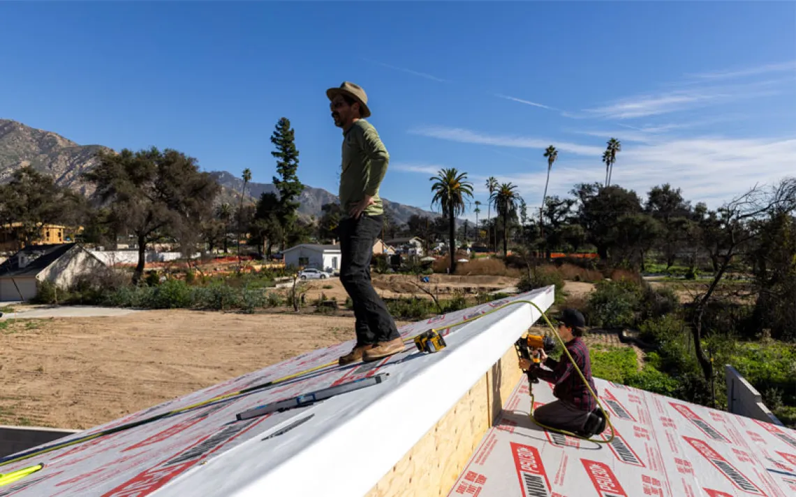
IN SUMMER, LONG BEFORE sunup, I head deep into the city with my camera and coffee to get my first close-up glimpse of the brand-new Sixth Street Viaduct. I find my people. Lots of sunrise folks with thermoses and snacks, stationed under the bridge. I miscalculated. I thought I'd be solo, but instead I've joined a party that's clearly been in progress for a while.
I slow-roll into a U-turn and take my first ride over the bridge toward Boyle Heights. At the side of the road, more cars and people idle in tight clusters, chatting, enjoying breakfast from coolers and take-out containers. The most glorious sight I encounter that morning, aside from the majesty of the bridge itself, tinted gold, and the camaraderie surrounding it, are two teenagers in red sweatpants, gray sweatshirts, and watch caps seated at the top of one of the arches, legs dangling, giving all who roll by below a royal wave from the wrist.
Taking in that early-morning joy, I hear an echo of what urban planner Rojas has always expressed to me: "People transform place and . . . they are transformed by it."
From 30 feet up, looking at the city, it's all yours. It certainly feels like it, if even for brief minutes. The shift in point of view is exhilarating, illuminating.
Envisaging is key. "It all starts with changing perception," Rojas told me. What we salvage or nurture begins with us. "It's not just Joe's [Biden's] plan but the whole nation's," Rojas said. "It's our work. If we can change perception, people's perceptions of possibilities on the nation's land, then we can achieve something."
In this sunrise moment, replaying Rojas's words, strange as it sounds, I almost don't want a finished, tightly curated, programmed park site. I almost want to leave it loose, let the urban be wild, let us determine with our footprints and high jinks what story we will leave for people to know about who we were—these 21st-century Angelenos who commandeered space, embroidered themselves on it with rituals, dreams, and ceremonies, and left artifacts and encoded messages to tell one more layer of the story.