Grande Slam
Although it's rarely paddled these days, the dehydrated Rio Grande can still hand out a drubbing.

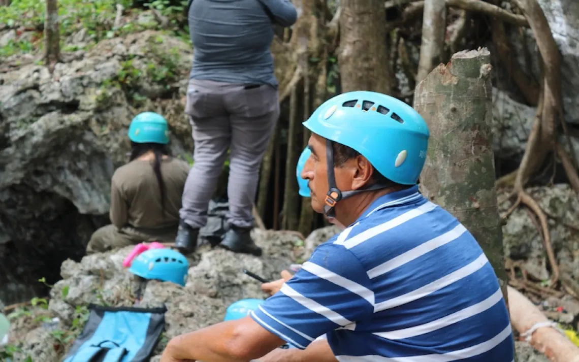
Paddlers enter the Rio Grande's lower canyons, a stretch of river downstream from Big Bend National Park. | Photo by Rob Kesselring
A CENTURY AGO, the torrents of the Rio Grande through the Big Bend country of southwest Texas mocked the best efforts of explorers to conquer the river. "Foaming and tumbling in a furious manner," Army Lieutenant Nathaniel Michler wrote in 1852, the river is "totally unmanageable."
Today, the fury has been calmed. Dams, diversions, hotter temperatures, and diminishing moisture have all taken a toll. Since Michler's time, the river that once served as a moat between countries has seen its annual flow decline by more than 80 percent at the point where it enters Big Bend. Still, it is premature to write the river's epitaph, as I recently learned on an 83-mile paddling trip through a stretch that Michler had deemed impassable. In fact, we probably should have paid more attention to his cautionary words, because even a parched and weakened river can still slap you around.

Running a rapid in the lower canyons, where exposed rocks were the main hazards.
Our group met in Terlingua, a bleached Texan hamlet just outside Big Bend National Park. There were seven of us. We'd come from as far away as California and Michigan, and though we were all experienced paddlers, none of us had been on this stretch of river before. We'd been brought together by Rob Kesselring, a Minnesotan who has been leading trips on Canadian rivers for many years, and whom we'd all canoed with in the past.
An outfitter drove us from Terlingua to the put-in at La Linda, a ghostly village dominated by the hulking shell of an abandoned DuPont fluorite-processing plant. The river's industrial past quickly gave way to prehistory as we glided through the limestone portal of Heath Canyon, which enclosed us in walls soaring several hundred feet high.
To our left was the Black Gap Wildlife Management Area; to our right, Mexico's Maderas del Carmen Flora and Fauna Protection Area. Both are part of a 3.5-million-acre binational conservation region—about 60 percent larger than Yellowstone National Park. We passed a lone camper in an orange cap, and after that we didn't see another human for almost a week.
It wasn't until 30 years after John Wesley Powell's famous 1869 trip on the Colorado River through the Grand Canyon that anyone documented a successful journey down the Rio Grande. In 1899, Robert T. Hill, a member of the U.S. Geological Survey, floated 350 miles from the town of Presidio, Texas, into what is today Big Bend National Park and on through the serpentine lower canyons.
Hill and his crew were terrified much of the time. Huge boulders atop 1,000-foot cliffs seemed poised to fall into their camp. A notorious bandit named Old White Lip roamed the countryside, robbing and killing. But it was the fast-flowing river that frightened them more than anything. "Too much water was to be dreaded rather than too little," Hill wrote.

Lining a canoe through a rapid that could not be run because of low water.
How things have changed. By the time we arrived this February, chronic drought and another warm winter in the Southwest had left the water level too low to float our canoes through the park. In the lower canyons, however, along a wild and scenic stretch managed by the National Park Service, several springs supplied enough water to give us a taste of the old rambunctious Rio Grande, the one that had kept Hill in a continual state of anxiety.
For the first few days, we bumped across shallows and riffles, frequently portaging over rocks and sandbars. Our canoes rode precariously low from the weight of 18 gallons of potable water—a necessary burden on a river often laden with agricultural chemicals and elevated levels of E. coli.
After 11 miles, we entered Maravillas Canyon and came upon the first significant rapids. At this same spot, a detachment of Texas Rangers had fled the river in 1882. The leader of the expedition, Captain Charles L. Nevill, and two of his men had nearly drowned, and they had lost most of their food and ammunition. "I was carried down the river like I was shot out of a gun," Nevill wrote.
During our run, there was just enough water in the canyon to provide a bouncy ride over a cascade of standing waves, too small even to splash water into the boats. But the river grew faster and more hazardous as we continued downstream. The trickiest passages came where the river turned sharply and the current surged into forests of giant reed. A bamboolike invasive species, the reed (a.k.a. wild cane) wreathes the river for miles, growing 20 feet high in places and choking out native vegetation and wildlife habitat. Curling over the banks, the tenacious stalks can put an unwary paddler in serious jeopardy. If you let the river sweep your canoe into one of these thickets, you can be pushed sideways in the current and tipped over. We lost hats and glasses to the cane and broke a paddle trying to escape from it, but no one capsized.
Native to India, giant reed was introduced to this country for use in erosion control and windbreaks. Today, it is the most conspicuous sign of the river's ill health. As water flows have diminished, sediment has accumulated, allowing the reed and another drought-tolerant alien, salt cedar, to proliferate. These plants, in turn, hold sediment in place, which narrows and straightens the river channel, steadily eliminating the meanders and pools that are the nurseries of aquatic life.
ALTHOUGH THERE IS STILL WHITEWATER IN PARTS of the nearly 1,900-mile Rio Grande, the "Great River" today is more like a patient surviving on intravenous injections. A pipeline from the Colorado River system provides the Rio Grande with enough water—for now—to meet the needs of New Mexico's largest cities. Downstream in Texas, almost all of the Rio Grande water that flows through Big Bend comes from the Rio Conchos, a tributary that originates in Mexico's Chihuahuan highlands.

Repairing a canoe that collided with a boulder in Palmas Rapid, 40 miles into the 83-mile trip. No one was hurt, and the canoe was successfully relaunched.
Even with those infusions, the Rio Grande is in trouble. In 2007, the World Wildlife Fund listed it as one of the world's 10 most endangered rivers. One study shows that 7 of 36 native fish species in the lower canyons have disappeared, and 8 others are nearing the brink.
Since the 1940s, the main channel of the Rio Grande below the Rio Conchos has narrowed by more than 50 percent, according to a study published in 2009 by scientists at Utah State University. "The changes in the riparian corridor, fluvial deposits and aquatic habitat are extreme," park scientist Jeffery Bennett wrote in a report for the U.S. Geological Survey.
Annual flows from the Rio Conchos to the Rio Grande have also plummeted—from more than 700,000 acre-feet in the early 1990s to 100,000 in recent years, the result of drought, agricultural diversions, and population growth in the region. Climate change is expected to reduce current stream flow in the Rio Conchos by an additional 25 percent before the end of this century. "The actual environmental conditions in the Rio Conchos are unsustainable," scientists concluded in a 2009 study by the Center for Research in Water Resources at the University of Texas at Austin.
The prognosis for the Rio Grande is no rosier. The U.S. Department of the Interior estimates that climate change will cut current flows by an additional 14 percent over the next 40 years.
Despite these pressures, the river was far from lifeless during our trip. Coots, teal, great blue herons, and flashy vermilion flycatchers patrolled the water, while a variety of hawks coasted high overhead. Wild burros brayed at our passing. Bighorn sheep grazed on rocky hillsides a few hundred feet above the river.
One morning, we rounded a bend in time to watch a mountain lion saunter up a terraced hillside. It switched its tail and gave us a sidelong glance before disappearing into the shadows. Occasionally, hikers in the national park have been attacked by the big cats, but from our safe vantage on the river, the cougar was a thrilling sight, evidence that we were in a part of the world where one of nature's aristocrats still reigns.
As we traveled downriver, springs poured in from rock outcroppings and billowed out in aquamarine swirls. The water level rose, and the rapids became more boisterous. Five of the seven boaters had canoed down bigger, faster rivers in northern Canada. Maybe we thought we'd taken the measure of this river, forgetting that even the tamest streams can set traps for the heedless. Or perhaps we didn't take seriously enough the warning of the outfitter to be careful in the Palmas Rapid, where the river boiled through a narrow channel between the left bank and two large boulders.
The first canoe—with me in the bow and Kesselring, the most experienced paddler, in the stern—sailed through without a hitch. But the next two entered the rapid too close together. When the leader ran aground at the bottom of the narrow chute, the trailing canoe (the only one of the four with a single paddler) had no passing lane. The paddler, part of the Michigan contingent, who'd done a flawless job as the soloist up to that point, hesitated just long enough for the current to slam his boat into a boulder.
Like many accidents in rapids, the event looked deceptively inconsequential: a canoe sideslips languidly and collides silently with a rock. We didn't realize how bad it was until we surveyed the damage. The paddler had escaped injury, but the canoe, still pinned against the boulder, appeared to be mortally wounded. Its bow was folded back, its wooden gunwale was in splinters, and three jagged gashes had opened up below the waterline.
No one needed to explain the fix we were in—seven paddlers sharing three canoes already weighted down with water and provisions, with the most challenging rapids of the trip still ahead. We considered going for help, but the nearest town was 25 miles away, and I recalled Hill's take on the hiking option a century ago: "Should we lose our boats and escape the canyons, what chance of life would we have in crossing these merciless, waterless wastes . . . ?"
Which meant we had to fix the boat. First, we had to rescue it from the middle of the river. After an hour-long struggle to leverage it off the rock, we pulled it to shore and set to work. Luckily, one of us had thought to bring a fiberglass-repair kit.
We bent the bow back into a reasonable facsimile of its original shape. Then came the trickiest part of the job: reinforcing the hull.
"Does anyone have a Swiss Army knife?" Kesselring asked.
We looked at each other like passengers in a disabled rental car who'd neglected to check for a spare tire. Then I remembered I'd carried such a knife, like a rabbit's foot, on outdoor trips for the past 20 years, even though I'd never used it. I retrieved it from my pack.
Working with the awl from the knife, a pocket-size Versa-Tool, and a handful of bolts, we reattached as much of the splintered gunwale as we could salvage. Next, we plugged the gashes with fiberglass patches. Nicaraguan rum substituted for the solvent we needed to clean the hull before smoothing on the patches with resin. We improvised an extra thwart from a piece of driftwood to stabilize the bow and wove a latticework of cord to hold the sides together. We worked long into the night, then waited impatiently the next morning for the sun to rise above the canyon walls and harden the resin.
THE FINAL PRODUCT LOOKED LIKE A SOAP DISH, but it floated, and it didn't leak. The first test was a rocky, zigzag rapid nine miles downstream. The rebuilt canoe survived without a dent.
That evening, we made camp below Burro Bluff, on a sandy shelf between salmon-colored cliffs that framed a night sky incandescent with stars. We were on the Mexican side of the river, where we were easy prey for local bandits, according to a Border Patrol agent who admonished us after the trip was over for not being armed. But in this place, cradled by towering walls that had stood sentinel for centuries, we felt only a sense of profound well-being.
We were more careful from there on, hauling the canoes around several of the remaining rapids. Like Hill and his crew a century ago, we had the river to ourselves. (A National Park Service logbook had earlier showed that no other groups had visited the lower canyons in more than two months.) The specters of illegal aliens and drug smugglers have reduced recreation in the area, even though Border Patrol statistics for the past several years indicate that illegal immigration through the Big Bend region is a trickle compared with virtually all the other sectors of the border from San Diego to South Texas.
By the time we departed the lower canyons, our clothes were spackled with sediment, a grimy keepsake of an ailing river. The Rio Grande nourishes one of the great expanses of wild country on the continent; no other aquatic habitat in the region hosts more species, according to park scientist Bennett. But as the sediment accumulates, the river suffocates in its own mud. The precedent has already been set upstream from Big Bend, where a 200-mile stretch known as the Forgotten Reach is barely wet much of the year.
A generation ago, raft trips down the Rio Grande through Big Bend were commonplace. For the river to thrive again, Mexico will have to agree to more releases from the Rio Conchos. Such a deal won't come easy, especially as climate change and population growth lay claim to surplus flows. The United States and Mexico recently came to an agreement that allows more flow from the Colorado River to reach that river's water-starved delta. But to date, there has been little movement toward a similar accord on the Rio Grande. These days, restoration efforts are for the most part limited to costly, painstaking cane-eradication projects in Big Bend National Park.
Those of us fortunate enough to paddle the river through the lower canyons won't soon forget the experience: the stillness, the stars, the soaring buttes, the stone remnants of ancient settlements, the cougar tracks in the sand—all part of the "noble surroundings" that Robert Hill described a century ago. They seemed timeless then. Not anymore.
Reverse Flow: Texans Fight For Their Rivers
In 2007, the Texas state legislature, with much urging from the Sierra Club's Lone Star Chapter and the National Wildlife Foundation, passed a bill designed to improve the health of the state's major rivers—and the bays and estuaries into which they flow. Senate Bill 3 calls for scientists to determine how much water each river needs to maintain a vibrant ecology and mandates meetings between environmentalists and other stakeholders, such as farmers, water districts, and municipalities, to establish "environmental flow standards" for the waterways. We asked Tyson Broad, longtime research associate with the Lone Star Chapter, to explain how these ongoing efforts might affect the Rio Grande.
Sierra: From an outsider's perspective, it's strange to think of the Rio Grande as having a natural ecosystem, since we usually just view it as a cartographic feature—a line on a map. How do most Texans regard it?
Tyson Broad: Most people here identify with the river only because it's our southern boundary. But it's interesting: The poster child for the effort to get Senate Bill 3 passed was an aerial shot that showed the Rio Grande stopping just short of the Gulf of Mexico. The river was so heavily utilized and so overrun by invasive species that it had stopped flowing into the gulf. That became the symbol of what we as Texans needed to do if we want to save our rivers. Because in Texas, if you want to get people motivated, you do things as Texans, together.
Sierra: The Rio Grande is about 1,900 miles long, but it seems that relatively few people ever see it in person.
Broad: It's true. Most folks don't have a relationship with the river from a natural perspective. Some people experience it at Big Bend National Park, but that's not easy to get to.
Sierra: The stretch of river that Frank Clifford writes about here has a steady flow of water, thanks to local springs. But the vast majority of the Rio Grande is in pretty bad shape, yes?
Broad: It's one of the most degraded rivers in the state. We'll never get the flows back to what they were historically, because you've got dams all along the system. That's one of the Rio Grande's biggest problems: It doesn't get the big flushing flows that it used to get to transport the sediment downstream. The channel is becoming narrower and narrower.
Sierra: Safe to say, you'll never impose restrictions that are designed to save only the Rio Grande. Because it's not just about the river's health; it's about all the people who use it as a resource.
Broad: Right. It's a balancing act. That's what the stakeholders are tasked to do once they get the scientific recommendation: to balance the needs of the river with human water demands. As you can imagine, those debates can get contentious, but the process provides an opportunity to work together to find solutions. —interview by Steve Hawk