Paddling the Lower Columbia River Water Trail
A veteran mountaineer discovers that long-distance kayaking is a whole different kind of outdoor adventure
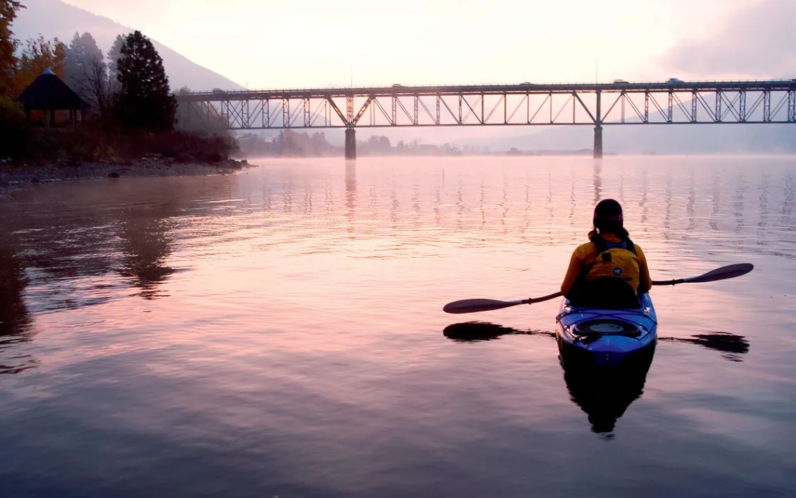
Photo by Aurora Photos/Alamy Stock Photo
I was folded into a kayak, paddling hard into the wind, and the muscles in my arms were tight. The hulls of our boats sliced through the green water as we watched silver salmon flash, ephemeral, against the light. The steep granite walls of the Columbia River Gorge flanked us (Oregon to the left, Washington to the right), and two bald eagles slid through the cold-afternoon air above. If we ignored our Gore-Tex gear and fiberglass paddles, we could almost convince ourselves that we were members of the Corps of Discovery.
It was late October when two friends and I set out to kayak a 146-mile section of the Columbia River, which runs 1,243 miles from the Rocky Mountains of British Columbia to the Pacific Ocean. Although all three of us are veteran backpackers and mountaineers, none of us had much experience as expedition kayakers. But months before, Bryan had read about a route known as the Lower Columbia River Water Trail—which runs from the Bonneville Dam to the ocean—and before we knew it, we'd committed to six days on the water. How hard could it be?
Our optimism may have been due to our astounding miscalculation of the time and effort it takes to kayak any meaningful distance. As we launched our boats into the water at Washington's Beacon Rock State Park, they were laden with tents, stoves, warm clothing, and a six-day supply of beef jerky and instant miso soup. "We'll just paddle out into the middle of the river and catch the current," Will said, squinting through the sheets of rain that were pummeling the kayaks. "It's got to be around here somewhere."
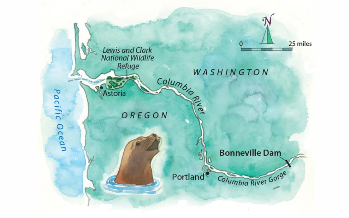
Map by Steve Stankiewicz
Four hours later, shaking with exhaustion and cold, we pulled our boats onto the shore. Immediately sinking into thigh-deep mud, I muscled my 80-pound vessel onto high ground, then went to find what would be our campsite for the night: an underpass beneath some train tracks. What the site lacked in charm, it made up for in shelter from the storm. "We paddled two and a half miles!" I shouted to my friends over the bone-shaking din of a train. Assessing the map and our tide charts, we agreed that we had underestimated the tidal influence this far from the ocean. To make the trip work, we would have to time our paddling to coincide with the ebb tide. For the next five days, we'd be slaves to the moon. I set my alarm for 3 A.M., stuffed toilet paper in my ears, chewed five ibuprofen, and tried to go to sleep.
The next morning, we had been pretzeled into our boats for hours when dawn broke as we paddled into Portland. Lines of cars pulsed on either side of the river. Staring at the commuters, I remembered the countless hours I'd spent on those roads. I had thought I was intimately acquainted with the Portland landscape—but I had never forced myself to move through it this slowly. Each paddle stroke propelled me only infinitesimally forward. The gray morning light melted into blue. Ever so slowly, we pushed toward the sea.
After Portland, the river turned northwest, and we entered a riverine ecotone where the suburban, the bucolic, and the wild intersected. One night, we camped on a sandy island draped in mist. One early morning, we boiled water for coffee on some public docks, then huddled around the warmth of a weak hand dryer in a county-park bathroom. At another point, I tried to have a pizza delivered to a boatyard. Once, a fat sea lion poked its head curiously out of the water, then glared at us in the rain.
Working with the tides was the only way to make progress, so we kept odd hours to stick to the ebb. We found ourselves talking about the river as though she were a person with moods and strong opinions about what we could and couldn't do. Mostly, it seemed, she wanted us to slow down, to rethink our assumptions about travel and adventure and progress. I started to time my paddle strokes to each heartbeat, searching for the water's pulse.
On the fifth day, we finally made it to landscape that felt alive: the eastern edge of the Lewis and Clark National Wildlife Refuge, a chain of some 20 small islands scattered along the last couple of dozen miles of the Columbia River. Thousands of ducks, tundra swans, and Canada geese gather on the sandbars there during their annual migrations. The fog kept us from seeing any of them, though birdcalls swirled on the wind.
The next day, we paddled into Astoria—which is within sight of the Pacific but before the notoriously dangerous Columbia River Bar. We had achieved our goal.
I dangled my wrists in the water and considered the arc of our journey. The river had humbled us by forcing us to slow down. It had reacquainted us with time. As I looked out at the water, I couldn't help noticing how deeply the river's channel had carved itself into the hills. No doubt it was the work of ages, something accomplished only through slow and steady labor. Just like paddling the river itself.
This article appeared in the July/August 2018 edition with the headline "On River Time."
Take a Sierra Club trip to Oregon or Washington State. Details at sierraclub.org/adventure-travel.
WHERE Lower Columbia River Water Trail, on the Oregon-Washington border
GETTING THERE The best place for paddlers to enter the water is at Beacon Rock State Park, west of the Bonneville Dam. From Portland, take Washington State Route 14 along the river.
MUST-READS The Lewis and Clark Columbia River Water Trail: A Guide for Paddlers, Hikers, and Other Explorers, by Keith Hay (Timber Press, 2004), and Paddling the Columbia: A Guide to All 1,200 Miles of Our Scenic and Historical River, by John Roskelley (Mountaineers Books, 2014)
PIT STOP Portland's Alder Creek Kayak & Canoe (aldercreek.com) is the best place to pick up missing equipment and get advice. Paddle directly up to the shop dock at 200 N.E. Tomahawk Island Drive.
BEST CAMPING SPOT There are plenty of places to camp for free along the route, but the Vista Park Campground (vista-park.org) in Skamokawa, Washington, boasts the best river view. Bring quarters for a hot shower and cash for firewood.
LAST SUPPER When you finally paddle into Astoria, head to the Astoria Brewing Company for a burger and a local IPA (144 11th Street, wetdogcafe.com).
MORE The Lower Columbia Estuary Partnership (estuarypartnership.org) has an interactive map that helps paddlers find campsites and develop a float plan.