Efforts to Restore the Los Angeles River Collide With a Gentrifying City
L.A. paved over a riparian watershed; who benefits from its restoration?
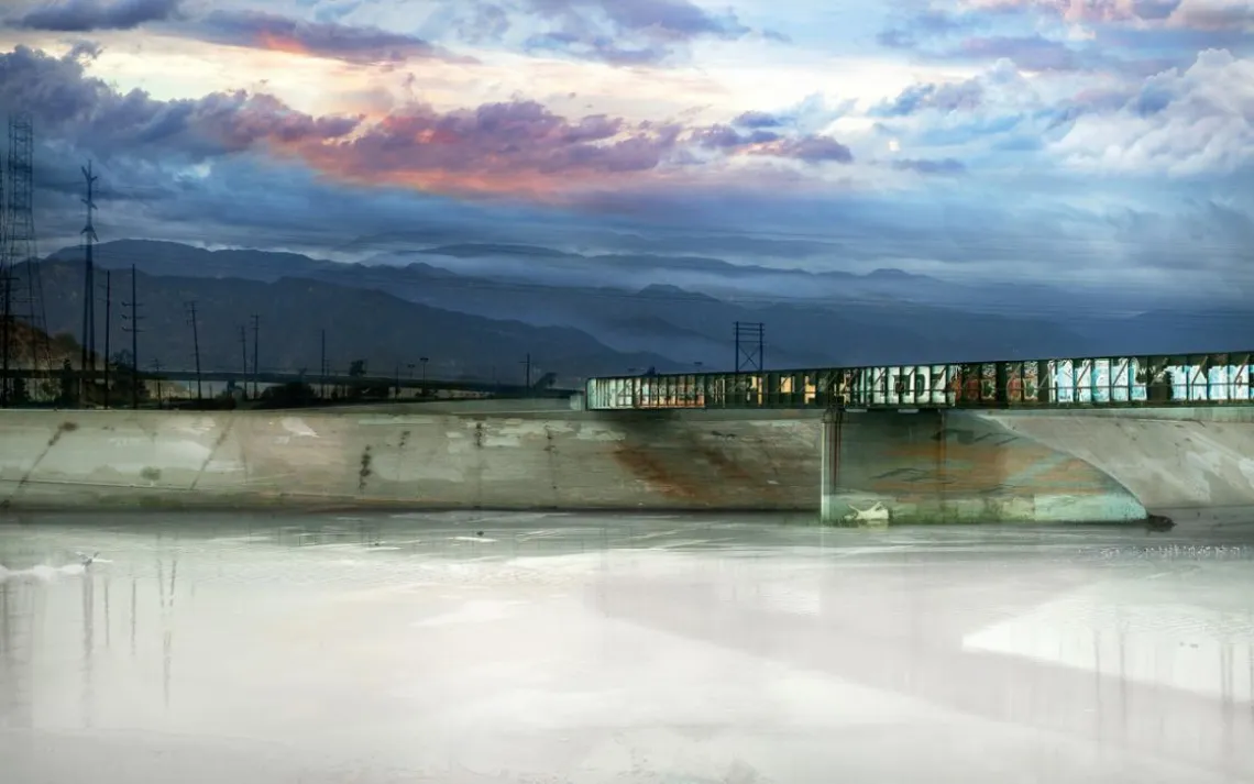
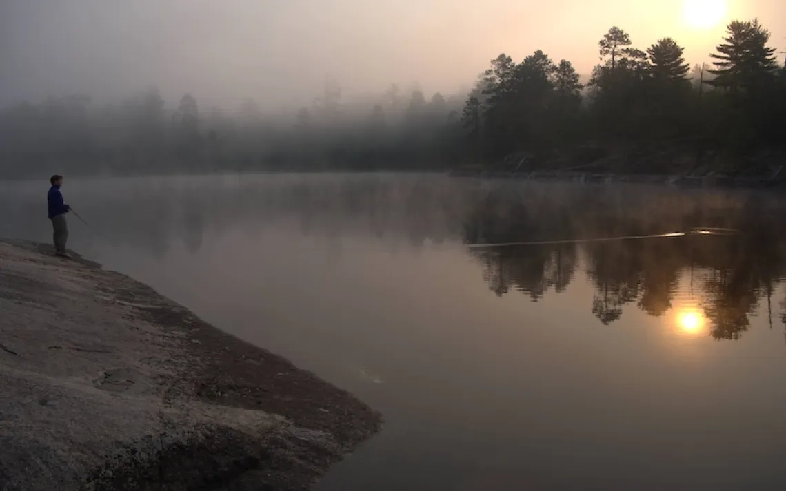
A multilayered photograph combines scenes from the L.A. River around East Compton with others along the 51-mile waterway.
IN MARCH, AS THE CITY OF Los Angeles was worrying about a possible rerun of California's recent epic drought, adrenalized meteorologists took to the airwaves to announce that a Pineapple Express was coming.
The "atmospheric river" is known for the long channel of water vapor that carries precipitation from the South Pacific to the West Coast, like a waterway in the sky. When the storm made landfall, it shadowboxed L.A. for three days but failed to wallop, and eventually most of the flood and mudslide warnings were rescinded. Still, it was enough to push a torrent of water down the giant, 51-mile-long concrete gutter known as the Los Angeles River, which snakes through the heart of the city.
Three centuries ago, the Los Angeles River was a rich riparian ecosystem—a burbling channel meandering along the base of the Santa Monica Mountains and through miles of wetlands and marshes. Cottonwoods and oaks dotted its banks. Grizzly bears hunted for steelhead along its shores.
That watershed would be unrecognizable to Angelenos today. Buried beneath miles of riprap and cinder block walls, hidden behind warehouses and chain-link fence, the Los Angeles River is little more than a sprawling drain. Except for three areas—in the Sepulveda Basin, the Glendale Narrows, and Long Beach—the entire length of the riverbed is encased in concrete, making it a flood-control channel on the one hand and a dumping ground on the other; for some, a canvas for graffiti, while for others, a place to fish, to jog, to daydream. The "river" has been a scene-setter for Grease, The Italian Job, and Terminator 2. Its steep walls slope and curve through some 32 miles of L.A., with the remaining span twisting through Compton, Long Beach, and 14 other cities. This serpentine gray scar zigzagging around freeways and city streets seems to lack a purpose, or an identity.

Yolanda Hernandez in River Garden Park
Efforts to restore and beautify the river date back to 1930, when Frederick Law Olmsted Jr. proposed a system of contiguous parks and greenways covering 71,000 acres—a plan that went nowhere. Now, the Los Angeles River is again at the center of a heated public-works debate, only this time, real money has been dedicated to revitalizing the once-thriving riparian landmark.
The city and its LARiverWorks policy team currently have a project either under way or in design for every mile of the river within city limits, aiming to improve connectivity, increase open space, and restore habitat. New bridges and trails will accommodate people on foot, bikes, or horseback. At some locations, such as the old Union Pacific Railroad Taylor Yard freight-switching facility, known as G2, it's possible to remove concrete and terrace back the riverbank to have a much wider, more meandering natural river. Plans for ecosystem restoration include everything from new parks and greenways to—in the case of one area south of Main Street near Chinatown—an actual channel change and a habitat terrace.
But to whose benefit? As the city embarks on the implementation of its ambitious Los Angeles River Revitalization Master Plan, adopted in 2007, engineers, community organizers, landscape architects, and Mayor Eric Garcetti find themselves pondering a kind of urban-redevelopment Rubik's Cube. The solution to each problem seems to just scramble another side: Can the city develop and restore the Los Angeles River in a way that helps revitalize L.A.'s watershed and reconnects the river and the city for everyone, not just the most privileged?
On March 22, as rain from the Pineapple Express sluiced down, few people could be seen along vast stretches of the river's occasionally dilapidated bike paths and throughways, from its toothy grin at the Sepulveda Dam in Encino to the Port of Long Beach. The pitched red and blue tents of the homeless hugged the river's medians in some places and its steep, graffitied walls in others. At the Verdugo Wash, where stippled concrete banks near Interstate 5 slope toward downtown, raging waters surged beneath a riveted truss bridge. A metal grocery cart sailed down the channel like a lost toy boat.
The water itself was a rare sight: The river channel is empty for most of the year. What people see during the dry season is reclaimed wastewater discharged from the Donald C. Tillman Water Reclamation Plant in Van Nuys. By some estimates, though, a storm producing just one inch of rain can bring up to 5 billion gallons of water to the river from the surrounding mountains and water tables. Not that the Los Angeles River is an answer to the city's increasingly urgent water needs. At least not yet.
On this day, as on any day since nearly the full span of the river was paved over, the gushing water that sloshed and foamed down the concrete banks was on its way to the Port of Long Beach and its final destination: the open sea.
TURN ON THE TAP IN JUST about any neighborhood in Los Angeles and you'll fill up a glass of water that came from hundreds of miles away. That's because in many neighborhoods in the third-largest urban economy in the world, 80 to 90 percent of the water is imported.
"The joke about Los Angeles is that if a drop of water falls anywhere in the western United States, L.A. has a pipe to bring it to the city, but if a drop of water falls onto the city itself, you shunt it out into the ocean," said Jonathan Parfrey, the founder and executive director of Climate Resolve.
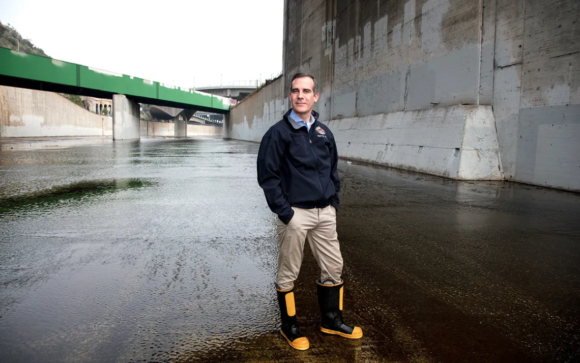
Mayor Eric Garcetti standing in the middle of the L.A. River on the west side of San Fernando Boulevard.
Few residents realize that what comes out of the faucet likely was once part of the Sierra Nevada snowpack, or flowed from Mt. Shasta or in the Colorado River—a paradox, given that many Angelenos live in a once-thriving floodplain. The city rests on the Los Angeles Basin, a lowland coastal area that was underwater millions of years ago. Then, like a huge alluviated bowl, the basin slowly filled in with rock, silt, and clay. The formation of the Santa Monica, San Gabriel, and Santa Ana Mountains around that bowl created the perfect geologic funnel for rainwater and, ultimately, seven major watersheds, of which the Los Angeles River is one.
Before Spanish missionaries founded El Pueblo de Nuestra Señora la Reina de los Ángeles in 1781, the area was populated by the Tongva people, whom the Spanish christened "Gabrielino." According to early settler accounts, the Tongva farmed sustainably, drawing from the river only what they needed, and were well aware of its potential for massive floods. The complex, unique geology of the Los Angeles Basin, with its interlocking and overlapping ridges and valleys, resulted in a wildly unpredictable river that often sent torrents of water tearing over its banks.
Not long after California became a state in 1851, the water needs of a booming population stressed the Los Angeles River to its breaking point. Meanwhile, the fitful river endangered the settlements multiplying throughout the floodplain. After catastrophic floods in 1914, 1934, and 1938, the city, at the recommendation of the U.S. Army Corps of Engineers, agreed to straighten the riverbed and pave it with concrete, deracinating whatever plant and animal wildlife was left. A complex of aqueducts, dams, and reservoirs was built to import most of the city's water; today, it delivers about 430 million gallons daily.
While contemporary critics often vilify the corps for destroying a wildlife watershed, the truth is more complicated. The paving of the river was the coda of a decades-long exploitation of its habitat, during which generations of settlers and city managers drained, rerouted, polluted, and overpopulated the basin's watershed. The corps was brought in to solve a problem, and in that, it succeeded. The vast waterworks established a flood-control system that protects millions of people crowding a floodplain.
Unfortunately, the corps installed a giant water superhighway that is ugly to behold and that generations of Angelenos have, not surprisingly, shunned.
"I never thought of the Los Angeles River as a river," said Yolanda Hernandez, whose home in Glassell Park is less than a mile from where the Verdugo Wash and the Glendale Narrows meet. She was sitting on a couch in her living room, hands folded in the lap of her black dress. "I just thought that's what it was called. For a long time I didn't even know it was there! I just thought that's where the water goes through when it rains."
Hernandez, a contract worker for the L.A. Unified School District, is one of six siblings in a Mexican American family that has lived in Glassell Park and neighboring Cypress Park for generations. Her mother, a housewife, was born in 1931 in East L.A.; her father was a carpenter who built everything from movie sets to the wood booths once common in L.A. restaurants. Hernandez and two brothers were born in Los Angeles, and her three other brothers were born in Ciudad Juárez, Mexico. Her parents bought their home in 1975; she bought hers in the same neighborhood in 1993.
Hernandez's parents never talked to her about the Los Angeles River, even though they lived right next to it. "When I was growing up, the river wasn't something that you went to go visit," she said. "The only time that you heard anything about it was when kids were skating there or something, or when some kid drowned. It wasn't something that you would go see. It was more like, 'Stay away.'"
When she was raising her own kids, there was virtually nowhere to go for outdoor activities. The only park in the area was Cypress Park. There was one baseball field for everybody, one gym, no picnic tables. If the family wanted to do something outdoors, they would drive to other neighborhoods to do it.
In 1998, the city announced that it would finally transform the withering Lawry's California Center, just a few miles from Hernandez's house, into the Los Angeles River Center, with Spanish-style fountains and gardens, bike paths, and picnic areas. She found herself thinking, "What took them so long?" and then, "What's the Los Angeles River?"
That was then. Today, Hernandez knows a lot more about the river, and she welcomes the city's efforts to revitalize it. Still, she remains concerned about what those efforts will do to gentrifying neighborhoods like hers and, especially, what it could mean for her kids.
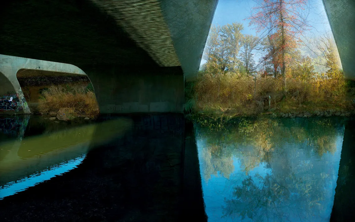
A multilayered photograph taken from within the Sepulveda Basin combined with scenes of forest growth.
Jessica Loya is Hernandez's 25-year-old daughter. "There are people like myself who want to move back to the community that I grew up in and buy a home—like my siblings are trying to do, my cousins are trying to do—and benefit from this green space, from this change," she said. "But we can't because we are being outpriced."
FOR DECADES, FEW THOUGHT OF the Los Angeles River as anything other than infrastructure. Then, in 1985, a poet named Lewis MacAdams and collaborating artists staged two Friends of the Los Angeles River performance pieces that included a 15-foot totem pole made out of driftwood collected from the river's banks.
Friends of the Los Angeles River (FOLAR) turned into a nonprofit movement at the vanguard of public efforts to restore the watershed. The group organizes an annual river cleanup, which in 2017 mobilized 10,000 volunteers who pulled 100 tons of trash out of the river's span.
"The river has been a 51-mile scar," Marissa Christenson, executive director of FOLAR, said. "When it was encased in concrete and no longer accessible as a natural resource, that also becomes a cultural scar. It's the area where a lot of disadvantaged communities have been relegated. So we have all sorts of different wounds in Los Angeles to heal."
In 2007, FOLAR helped fund an Army Corps of Engineers study titled Alternative With Restoration Benefits and Opportunities for Revitalization, the recommendations of which are considered the gold standard in ecological restoration for the river. That same year, the city's revitalization master plan codified urban-design guidelines for environmental improvements, accessibility, and economic development along 32 miles of the river.
The problem is, any time you fix up an eyesore in a place like Los Angeles, property values increase; new developments gentrify neighborhoods and push affordable housing further out of reach.
Case in point: The New York–based developer Pan Am Equities has proposed a high-end mixed-use development near south Atwater Village. The so-called Bow Tie Yard Lofts, a 419-unit apartment complex not far from Hernandez's home in Glassell Park, would include 720 parking spaces, 64,000 square feet of commercial space—and just 35 units reserved for low-income tenants.
Julia Meltzer is the founder of Clockshop, an arts organization in Frogtown (a section of the river known for its influx of frogs after rainstorms) that joined FOLAR in opposing the Bow Tie development. On the patio outside her studio, she laid the artist renderings of the apartment complex on a table. They depicted people walking, relaxing, and biking just beyond the complex walls. All the people shown were white.
Pan Am Equities called its development the Bow Tie Yard Lofts in a gambit to link the name of the development to a newly revitalized, community-focused public park nearby. (Under pressure, it later changed the name to the Casitas Loft Project.) "This is an example of how developers will behave in response to the river," Meltzer said.
But there are also examples of how to do development right. In 2017, the nonprofit developer WORKS proposed a community-oriented plan for the abandoned Lincoln Heights Jail, abutting the river. That plan included 122 housing units for low- and middle-income families, a daycare center, 39 units for the homeless, an arts space, and green space, too. WORKS lost out to another finalist in the end, but its plan was a community favorite that could serve as a model for other developments along the river.
GUSTS OF WIND BLEW FLAGS, buttons, and brochures off the display tables at the G2 parcel, located just a few miles from the Verdugo Wash. A dirt path led visitors past rusting concrete pylons. From there, the river looked like a drained salt marsh, with brackish water lapping at the occasional island of dead moss.
The city's Bureau of Engineering opened up the parcel to the public on January 20 for a self-guided tour, then followed it up with a community hearing a few days later at Sotomayor Learning Academies, which drew hundreds of people. The events were part of an effort to prioritize community participation in development projects like the one at G2: a 41-acre riverside property the city purchased in March for $60 million, considered the marquee project in the revitalization master plan.
Mia Lehrer is the founder of Studio-MLA, a landscape architecture firm that won the bid to redevelop G2 along with WSP, an engineering firm, and Mujeres de la Tierra (Women of the Earth), a nonprofit dedicated to ecological sustainability and environmental justice. Lehrer coauthored the 2007 master plan and has been involved in advocacy around the river since the 1990s. She grew up in El Salvador, where on weekends her family would often go to a beach 40 minutes away or go kayaking on a lake.
After moving to Los Angeles in the 1980s, Lehrer soon became fascinated with this "Los Angeles River" that looked nothing like a river at all.
"This isn't a river anymore; it's a concrete channel. How do you put that into the lexicon of ecology?" she said while sitting at a long table at Studio-MLA, located next to the river, a few days after the G2 tour. "It took people within the city and the county and smart ecologists and geomorphologists talking to the Army Corps biologists, all saying, 'How can we make this thing come to life?'"
Even if Lehrer and her team can solve the ecological side of the Rubik's Cube, developments like the Casitas Loft Project have residents and community organizers continuing to demand answers: How can the city balance the need for an affordable L.A. with pursuing the goal of a more accessible, more sustainable, greener river?
"The Los Angeles River is as complex, as diverse, as energetic, as troubling, as challenging as the diversity of this city of Los Angeles. So let's start there," Irma Muñoz said over iced tea at a coffee shop a few miles from the confluence of the Los Angeles and Arroyo Seco Rivers. Muñoz is the founder and president of Mujeres de la Tierra and has been doing community engagement work in Los Angeles for 20 years. "There are no simple answers and no right answers. That is what I've learned during my love affair with the L.A. River."
In 2007, Councilman Ed Reyes, then chair of the L.A. River Ad Hoc Committee, recruited Muñoz to spark community organizing around the city's efforts to revitalize the river. "There was this culture then that the river belonged to certain groups and certain people," Muñoz said. "He basically told me that the people who lived and worked around the river and enjoyed the river for decades were not part of the conversation and were not being heard, and he asked me to help him with that."
She started going door-to-door in Canoga Park and quickly learned that he was right. "I go up there, and it's very clear to me based on the people that I've spoken to that they feel their opinion doesn't matter. That everything that is improved in Canoga Park is at their expense and the expense of the neighborhood."
Muñoz remembers one woman—a mother dropping off her kids at Canoga Park High School—who made the point clear when Muñoz approached to get her opinion about river-development ideas.
"See that donut shop across the street?" the woman asked her. "For a dollar I can buy a cup of coffee and a donut. Now turn your head to the left: Westfield Mall. There's a Starbucks. You tell me what I can buy there for a dollar at that Starbucks? So why give you my opinion when I'm never going to be able to enjoy it, number one, and me and my community are going to be the victims as the result of redevelopment?"
TWO WEEKS AFTER THE Pineapple Express left town, Mayor Garcetti walked out into the Los Angeles River from a maintenance road on the west side of San Fernando Boulevard. He came there to have a conversation with this reporter about the future of a river that he had long enjoyed as a kid and that he's defended as a public official. The mayor, wearing rubber rain boots, stood in the middle of the riverbed, splashing wastewater all around.
"The river is the city," Garcetti said while a train rumbled overhead. "It's our birthplace. It sustained Native peoples here. It allowed the Pueblo of Los Angeles to be built. It was something we sought to use, to control, and we turned our backs to it. Now we seek to coexist with it and to live side by side with it, and to turn our faces to it once again."
Garcetti grew up in Encino, about a 10-minute walk from the river. His father would take him and his sister on outings along its east banks, often photographing them playing there. His grandfather told them stories about what the river was like when there was a flood: frogs everywhere.
While Garcetti's childhood outings are part of why the river's revitalization means so much to him, the other part is FOLAR's Lewis MacAdams: MacAdams was Garcetti's creative writing teacher in high school.
"My father and Lewis were the two people who really taught me about the river," Garcetti said. "One brought me to it; the other brought me to its potential."
The city and its LARiverWorks policy team have completed numerous miles of public-access projects along the river, including one in the San Fernando Valley to connect 12 miles of gaps there and one bridging another eight-mile gap downtown. Others are in the works: An iconic cable-stayed bridge will connect Griffith Park with Atwater Village. The Albion Riverside Park Project on the east bank in Lincoln Heights will be the first new park in that community in over a century.
But the long-standing problem of the river's environmental impact has yet to be addressed: There are no mechanisms in place for cleaning storm-water runoff draining from dirty city streets into the river and, from there, the ocean. A 2010 swale pilot project in Atwater proved that runoff can be captured and cleaned before it makes its way into the river channel—but nothing system-wide has been done yet.
The city also faces an uncertain future as its reliance on imported water collides with the realities of climate change. According to the 2016 Los Angeles Basin Study, by mid-century a temperature increase of 1.8°F to 5.4°F will reduce snowfall at lower elevations and decrease snowpack, with the Sierra Nevada snowpack shrinking by as much as 40 percent from its historical average. By the middle of the 21st century, a water shortage worse than the 1977 drought could occur in one out of every six to eight years; by the end of the century, in one out of every three to four years. Mayor Garcetti has proposed a climate initiative, Sustainable City pLAn, with a long-term goal of getting half of the city's water from local sources by 2035, which will require cleaning up the San Fernando Groundwater Basin aquifer and 150,000 acre-feet per year of storm-water capture.
But the other side of the Rubik's Cube still hasn't been solved: How do you make a greener, more sustainable L.A. while also making sure it stays affordable?
"I think that if we did nothing with the river, those forces of high rent, of displacement would still be here," Garcetti said. "We need to address those regardless of what we do with the river. We have to make sure that affordability is not just a consideration but the foundation when it comes to the redevelopment of any of those projects."
THERE IS NO ONE solution that solves every side of this complicated puzzle. But maybe that's not the point. Instead of looking at the Los Angeles River as a single, scrambled Rubik's Cube, perhaps it's better to look at it as dozens of them—each with its own patterns and combinations, waiting to be solved.
It may not be possible to stop the market dynamics transforming the city. But when Angelenos turn out to make their views heard, to demand justice in housing and justice in river restoration, they can at least help shape those dynamics into a process that better serves everyone, as well as the river their city began abusing so long ago.
That's why Irma Muñoz is organizing events like one at a retirement home this past March, billed as "Find Your Voice, Speak Up and Speak Out."
"People should be raising their voices and be engaged," she said. "We owe it to the L.A. River. We owe it to her. She's been waiting all these years for someone to heal her. I think in the process of healing the L.A. River, we'll be healing ourselves."
This article appeared in the July/August 2018 edition with the headline "River of Angels."