A Hiker Revels in an Appalachia Trail Without the Crowds
Pine Mountain is an ecological treasure in a region known for resource extraction

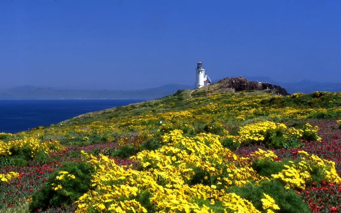
The Pine Mountain State Scenic Trail traces a portion of a 125-mile fault block through one of the largest unbroken forests in Kentucky. | Photo courtesy of Kentucky Department of Parks
I was somewhere above Indian Grave Gap when I saw my first yellow lady's slipper⎯the only one I'd see in the course of my two-day backpacking trip along the Pine Mountain State Scenic Trail. I let out a holler, a celebratory howl. My friend Michael, trudging uphill behind me, asked with a laugh, "Good news?"
He knew I'd found something I'd been hoping to see: the orchid Cypripedium calceolus, also known as the moccasin flower. It's a Kentucky native, unlike me. I've lived in the state less than a decade, but in that time, I've come to love the unique ecology of central Appalachia.
In 2016, I attended an artists' retreat on Pine Mountain, where I was introduced to the mountain's flora and fauna and its unusual geology. The 125-mile fault-block ridge stretches from Virginia to Tennessee, serving as an important wildlife corridor for everything from migrating raptors to black bears to salamanders. Since the retreat, I had returned often, but this was my first backpacking trip here.
Flowers dominated the slope where we stood. Mayapples, larkspurs, and an assortment of trilliums blossomed among the cobbled loaves of weathered sandstone. We'd only been hiking a few hours, and already we'd seen ravens, signs of a bear, an empty turtle shell, and a number of red efts⎯brightly colored juvenile eastern newts. It was the first weekend in May, Kentucky Derby weekend, and horses were the furthest thing from our minds.
I took a few photos of the yellow lady's slipper on my phone, and we continued our steep ascent. The Pine Mountain Trail runs 44 miles along the mountain, crossing one of the largest contiguous forests in Kentucky. The part we were hiking, the 15-mile Highland section, rises and falls along a ridgeline of 320-million-year-old Pennsylvanian sandstone, reaching as high as 3,200 feet. We followed a well-marked trail that twisted up and down through deep woods and exposed rock. Chestnut oak and Virginia pine dominated the high, dry ridges. Eastern hemlock and fern groves populated the moist ravines. At Twin Cliffs overlook, we paused to take in the undulating hills of Virginia spreading to the east.
Late in the afternoon, we arrived at the Adena Springs shelter⎯one of several designated camping spots on the Pine Mountain Trail. A steady rain fell as we set up our sleeping gear in the top loft and our cooking gear on the roofed picnic table. We were glad for the composting privy as well as the pile of firewood we'd use to dry our clothes in the morning. As evening fell, we were amazed to see a head lamp emerge out of the darkness; a lone hiker from Wise, Virginia, had set out from the opposite end of the trail at 5 P.M. and hiked a mountainous eight miles, mostly in the rain and failing light. In the morning, he continued on toward trail's end above Elkhorn City⎯a three-day journey end to end.
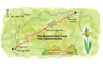
Map by Steve Stankiewicz
We set out early the next day, climbing out of the forest and up to the mountain's bare lip, with its views over the Cumberland Plateau to the west. We stopped for lunch under the soaring roof of a rock shelter, waiting out yet another squall, then gingerly crossed the 45-degree wet slopes of Mars Rock, whose name aptly describes an unearthly terrain of pitted sandstone. We descended to Bad Branch, a designated Kentucky wild river, where I spotted yellow birches huddled against the shores. We wiggled through the rock formation known as the Lemon Squeezer and later passed Eagle Arch, one of several imposing arches along the way. Over the course of the entire day, we came across only three people, hiking together in a group.
Part of what makes Pine Mountain special is its location in a region with a history of extensive resource extraction. The mountain itself is free of merchantable coal and thus has remained largely untouched. But threats such as logging, natural gas development, and limestone quarrying loom. The Kentucky Natural Lands Trust, the Office of Kentucky Nature Preserves, the Nature Conservancy, and the Pine Mountain Trail Conference have all pitched in to preserve the mountain⎯and the trail along its peaks. One goal: to extend the route to the Narrows, where the Cumberland River shoulders its way through a gorge in the mountain, a hiking distance of over 100 miles. This trail will serve as a vital link on the Great Eastern Trail, much of which is still under construction. When completed, that trail will run from Alabama to Upstate New York⎯becoming, in essence, a second Appalachian Trail.
Late on our second day, we arrived at the Flamingo shelter, a half mile from trail's end. Sunlight broke through the remaining clouds. Eastern phoebes and hooded warblers flitted among the trees, and in the advancing twilight a whip-poor-will sang out from a creek gully. We sipped bourbon by the fire, glad to spend one more night on the trail, even though temperatures were expected to drop to the 30s. We didn't think about whose horse had won the race, and when we came down the trail the next morning to meet the shuttle in Letcher Gap, it was like walking into our own winner's circle.
This article appeared in the March/April 2019 edition with the headline "Appalachia off the AT."
WHERE Pine Mountain State Scenic Trail (Highland section), Kentucky
GETTING THERE This is best hiked as a one-way route. It's easy to shuttle cars between Pound Gap off US 23 and Letcher Gap off US 119. The Pine Mountain Trail Conference offers a shuttle for $35 ($10 for each additional passenger).
WHEN TO VISIT Any time of year, though in summer it can be hot and buggy and water is hard to find. Spring, especially April and May, is peak wildflower season. October and November are the best months for fall colors. In winter, the trail can be snowy and icy.
PERMITS None required.
PRO TIPS Start the hike with plenty of water. Water sources are sparse along the trail. About halfway along from either direction, just below the Adena Springs shelter, are two reliable sources, with several more before the Flamingo shelter. Watch for poison ivy and ticks. For a two-night camping trip, with a stop at each shelter, start at the northern trailhead from Pound Gap on the Kentucky-Virginia border (US 23).
MUST-SEES Rock outcrops like cliff-edge Twin Cliffs overlook, High Rock, Box Rock, and Mars Rock offer vistas, some west over the Cumberland Plateau and some east to Black Mountain. Eagle Arch is a rare sandstone arch, and Baker's Rock is a house-size boulder.
MORE bit.ly/pine-mt and bit.ly/pine-mt-2
Take a Sierra Club trip to Kentucky. For details, see sc.org/adventure-travel.