The Meridian Chaser: Ricocheting Between Climate Divides Old and New
One writer road-trips through the Great Plains, witnessing the effects of the eastward-shifting 100th meridian

I CAN SEE THE PLANE'S reflection in the waterlogged fields of the Rio Grande Valley as it approaches the tarmac in late July. Outside Harlingen, Texas, flowering sorghum plants droop like weary refugees, marooned in the swamp. Corn. Sugarcane. Cotton too. A resident will later tell me that the water has been standing for weeks. Entire crops have been surrendered. An unusually wet summer following an unusually wet spring was enough to break the valley's multiyear drought, but the rain has proved to be too much too soon.
My plan is simple enough: Drive 2,000 miles north to Fargo. Stick to the 100th meridian. Ask questions. Observe.
The reason is a bit more complicated.
In 1878, a government geologist named John Wesley Powell, also a swashbuckling one-armed Civil War veteran, submitted to Congress his Report on the Lands of the Arid Region of the United States With a More Detailed Account of the Lands of Utah. By way of explaining the novel demands of this rain-shy region, Powell identified the 100th meridian, running vertically through the Great Plains, as America's climate divide, an invisible boundary between humid East and arid West.
"It is doubtless more or less meandering in its course throughout its whole extent from south to north, being affected by local conditions of rainfall, as well as by the general conditions above mentioned," he wrote. Temperature and altitude, mostly. "But in a general way it may be represented by the one hundredth meridian, in some places passing to the east, in others to the west, but in the main to the east."
Thanks largely to Wallace Stegner, whose 1954 classic Beyond the Hundredth Meridian rescued Powell's legacy from the historical dustbin, the geologist is celebrated today as a visionary whose blueprint for a more communal and deliberate use of the public domain, had it been adopted, "might have changed the history of a great part of the West." Powell proposed irrigation and pasturage districts run by cooperative unions, a pragmatic solution both for conserving natural resources (chiefly water) and for avoiding the litigation all but certain to arise if the free-for-all out West continued. Stegner called this unprecedented report a loaded gun, "for it challenged not only the initiative, individualism, and competitiveness which were quite as marked as co-operation in the American character . . . but it challenged as well the folklore bred up through generations of frontier farmers in a country of plentiful rain."

Congress dismissed his counsel, but Powell managed nevertheless to imprint the 100th meridian into what Richard Seager, a Columbia University climate scientist, calls our "national psychogeography." To most Americans today, it is where East and West collide. Even if we don't know it, we know it. Like "escrow," or "Michael Dukakis." A vague but definite something we've heard people say.
Regardless, scientists say that the "effective 100th meridian" is on the move. In March 2018, 140 years after the release of Powell's report, Seager was the lead author on a two-part study published in Earth Interactions. The first part used hard data—climatological, hydrological, agricultural, economic—to show how Powell's climate boundary has organically shaped human settlement, no regulation necessary. "In the end, as people used the land, they realized that these climatic limits that Powell was talking about are very real," Seager told me before I left to find the meridian. "And over decades, they've made that adjustment."
But the second part of the study was perhaps more surprising. Because of climate change, the effective 100th meridian, it found, has shifted approximately 140 miles east since 1979, closer to the 98th, and will continue shifting as greenhouse gas emissions climb, increasing aridity along the way. For those who live on or near the line, especially those tied to the land, the consequences could be dramatic. Less corn. More wheat. Expanding rangeland. Increasing irrigation. And what of the aquifer supplies in the southern Great Plains, where the recharge is much slower? What of the cattle that rely on all that corn, and the suffering forage too? And what of the small towns holding their breath, propped up by the wobbly foundation of agriculture—the grocery stores and diners and local mechanics?
So I'm chasing the West eastward from the bottom up, from Texas to North Dakota, Brownsville to Bismarck, the Laguna Madre to Lake Sakakawea, cutting through my home turf in central Nebraska along the way. Roughly 2,000 miles of corn. Perhaps the longest, flattest run in North America. I want to see what's changing, or maybe who's changing. I want to meet these meridian riders myself, ricochet between the old line and the new. I want to spread Seager's study out like a map and drive my dusty rental car straight through it.
I WEIGH THE PROS AND CONS of a coastal detour as I wait for the teenager behind the rental counter to finish his dead-eyed paean to the Ford Fusion. South Padre Island is just one degree shy of the new climate divide, and as Chris Gabler, a professor at the University of Texas Rio Grande Valley, was quick to note, the rest of my trip promised to "get pretty redundant." A lot of farms, he told me before I left. A lot of miles. If I didn't take the opportunity now to smell that briny potpourri, I'd miss it altogether.
I meet Gabler on the boardwalk of the South Padre Island Convention Centre, where he often brings students to show off the novel ecosystem of the Laguna Madre. He looks like the plant community ecologist that he is: straw hat, patchy beard, cargo pants. The boardwalk is less than a quarter mile long but offers a near-perfect illustration of how the coastal wetland ecosystem is changing in South Texas, he tells me. Gabler bends over the wooden railing and points toward an empty mudflat just a few yards below. Brown on brown on brown. A single blue heron perched on a tiny green island of sea oxeye daisies. A carpet of flowering yellow turtleweed. Behind it all, a buffer of black mangroves still recovering from the unprecedented ice storm that crippled Texas last February and a hazy caravan of pontoon boats drunkenly floating in the bay.
"This is what the aridity gradient looks like on the South Texas coast," Gabler says. "Less freshwater input means more salt accumulates, which means that the mangroves get pinched. They don't get as tall. The algae mats and the mudflats creep outward, and everything else shrinks back."
Because the Rio Grande Valley is so dry, and the lagoon so shallow, more water evaporates from the Laguna Madre than flows into it from the rivers of South Texas. It's what they call a "reverse estuary," Gabler tells me, meaning the lagoon is saltier than the ocean itself. The ecological chain reaction of such a rare condition has made the Laguna Madre a hot spot for migratory birds (including the invasive Midwestern snowbird) and butterflies and in turn created a $463 million ecotourism industry. But it's a delicate balance, Gabler says, and one that increasing aridity—the shifting meridian—could easily upset.
"Even a 10 percent change in freshwater could mean a 20 to 25 percent reduction in [mangrove] biomass," he says. "And that means 20 to 25 percent less plants. That means at least 20 to 25 percent fewer birds and butterflies and fish. And what does that mean for birdwatching? And butterfly watching? And . . ."
The boardwalk cuts through a beleaguered mangrove forest and finally burps us into open bay. The mainland is just visible on the horizon. A water tower. A sailboat. An old beach house. We watch a bloated redfish loiter in the blue-green waters below us before we part ways with a sweaty handshake.
"North of Corpus Christi, it's all just farms," Gabler says with a boyish grin. "I know that's not true, but exciting stuff happens at the edges. You're at the edge here!"
My whole trip is premised on the edge, of course, on what I might find out here, where the humidity runs dry. Just two hours later, I find myself on another edge, this one entirely conceptual. Marianna Wright at the National Butterfly Center invites me to join her and her husband for a sunset cruise on the Rio Grande, straddling the international border. The river is high, and the cooler is stocked with Shiner and Dos Equis.
To the south, manicured public parks and swanky riverfront villas interrupt large swaths of private ranchland crowded with invasive carrizo cane. A pair of Jet Skis race around the bend. A party boat crawls upriver, blasting music. To the north, a golden sunset illuminates the newest section of America's border wall, something the Wrights—both former Republicans—joke about with a sort of gallows humor.
In July 2017, Marianna Wright found a crew of chainsawwielding government contractors tearing through the 100-acre National Butterfly Center to clear a path for the wall, she tells me. The North American Butterfly Association, which owns the center, immediately filed suit to halt construction, and the battle has hijacked Wright's attention at the center ever since. If completed, the wall would destroy critical and hard-won butterfly habitat and restrict access to nearly 70 percent of the center's riverfront property. Wright is currently a plaintiff in two separate lawsuits targeting the steel monolith.
"And so while the US has been building a border wall for the last decade or so, Mexico has built three new dams [upriver]," she says as the muddy current flows around pontoons. "They know climate change is coming, and they're protecting their water source."
I wonder aloud whether the Wrights are outliers here in the Valley, whether John and Jane Doe in nearby McAllen, for example, are equally concerned about climate change. The boat erupts in macabre laughter.
"We have a syndrome here called mañana. We live in the land of mañana," Wright says. "Today the fruits and vegetables come up out of the ground magically. They fall out of the trees magically. And I don't know if people understand that's not going to last."
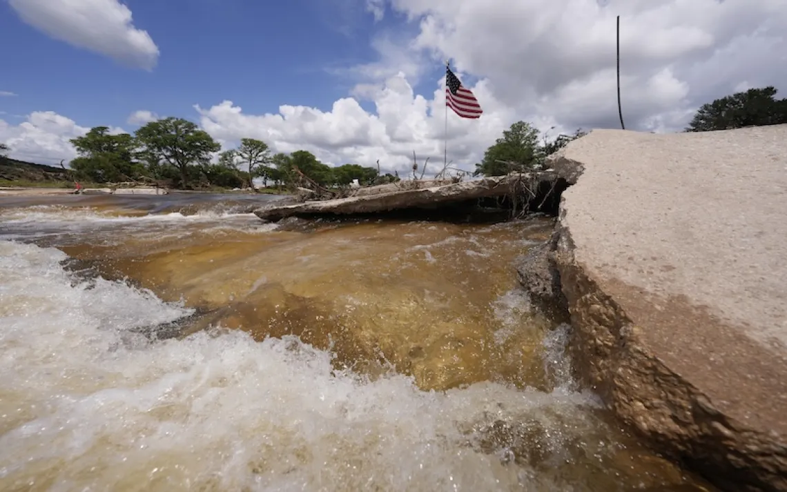
THE NEXT MORNING, as a ghoulish caravan of Border Patrol blimps looms over the Valley, I drive 70 miles west to Falcon State Park to see the water levels for myself. The Falcon Dam near Roma provides water for irrigation and hydroelectricity in both the United States and Mexico. Following the Wrights' advice, I head straight to the boat ramp, but the ramp is stranded in the bottom of a bone-dry inlet and barricaded from the parking lot. Fishermen instead haul their boats straight to the water—several hundred yards down—via sandy makeshift trails. The reservoir is at just 26 percent capacity and will drop lower still as the summer drags on.
I crank the AC and punch west to Laredo before cutting north on Highway 83, slaloming through a purple Hill Country at sundown and finally calling it a night in Abilene. In the morning, I drop by a sale barn on the northern edge of the city. Surely the local cattlemen, tied daily to the mesquite grasslands of the Panhandle Plains, will have something to say about an increasingly arid climate.
"Every year we have summer, they blame it on climate change," says Randy Carson, who owned the Abilene Livestock Auction for almost 20 years. He's sitting in a lawn chair outside the front door when I pull up, a can of dip protruding from his breast pocket. "It gets hot every goddamn summer and cold every winter. None of that's changed."
Carson finally sold the business in 2019 but still runs some cattle north of the city and visits the sale barn daily to feed Floozy, the cat he left behind.
"We've had the coolest spring we've had here in years. Now is that due to climate change?"
It's a rhetorical question.
"Bullshit," he says.
I don't stick around for long. After he blames government dysfunction on poor parenting and "the long hair and tattoos and britches down to their ass," I bid him farewell. Vexing as our conversation was, part of it reiterated what I would hear time and again throughout the trip. Most folks living near the climate divide already expect the unexpected. No matter their view on climate change, they resigned themselves long ago to whiplash.
"You have seasons where you get a lot of rain and the next season you don't," Carson told me. "That's happened forever."
THAT NIGHT, I CAMP OUT at the Wichita Mountains Wildlife Refuge near Lawton, Oklahoma, 200 miles northeast of Abilene. It's roughly a million degrees in the tent, and I'm wide awake in a sweat-logged sleeping bag when a snorting buffalo brushes my rain fly around three in the morning. A storm finally cools things down as dawn slants through the oak trees, but it's time to move on. Jeffrey Basara, an associate professor of meteorology at the University of Oklahoma, has agreed to meet me at the refuge, one of his favorite weekend getaways, for an early-morning hike.
The rain quits just as we hit the Kite Trail at Lost Lake. Under a slate-gray sky, the landscape explodes with color: slick red granite, cool green lichen, yellow coreopsis bursting like confetti between the rocks. Below us, the lake stares back without a ripple, and the ancient Wichitas—shaggy with bluegrass—huddle around us like the Sooners' defensive line. Rarely do the dog days of summer look so good here in central Oklahoma, Basara tells me.
"And that's where this message gets hard, because it's only supposed to be hot, dry, and really bad, and this isn't hot, dry, and really bad," he says as we descend into the trees. "I don't know what you see, but I see an ecosystem that's happy."
One week last June delivered two months of rain, and the system is still responding. It's an anomaly, but the anomalies are becoming less anomalous as climate change rattles the system. The variables more variable. The extremes more extreme and more frequent too.
"Humans, by nature, are A plus B equals C, but what we're dealing with here is A plus B plus C times D divided by E, you know, squared by F. You're getting into linear and nonlinear features that cascade out in time," he says. "To get people to think in the big picture is really hard."
Basara recalls the recent drought that nearly brought Wichita Falls to its knees. Nearby Lawton too. Both were down to a single month's water supply, he says. Forage was drying up. Ranchers were selling cattle, consolidating, quitting the business entirely.
"They levied a tax on the citizens to fund cloud-seeding efforts. Think about that!" Basara says. "This is the land of no taxes, right? That's where the desperation came in."
Though I didn't know it when I first reached out, Basara served as an anonymous reviewer of Seager's paper on the shifting meridian. He was envious of the study, he says, impressed with the research and concerned by the implications. I ask him where his mind first wandered when the paper crossed his desk. Another Dust Bowl? Mass migration? He doesn't skip a beat.
"The I-35 corridor," he says, from Oklahoma City to the Rio Grande Valley. One of the fastestgrowing regions in America. According to the Texas Department of Transportation, the corridor's population is projected to increase by 82 percent by 2040. And at some point, Basara says, if aridification continues and the effective 100th meridian keeps moving east, "you will reach a tipping point where it's not sustainable."
We tie off a three-mile loop and hit the road. The good doctor is due back in Norman, and I'm anxious to hit Kansas, if only to know I've made it halfway.
I make a fool of myself in the sagebrush oblivion to follow—knocking on isolated farmhouse doors, introducing myself to strangers, racing to explain the premise of my trip before I lose my breath or my will or my nerve. A California transplant near Laverne, Oklahoma, sets her shotgun aside after sizing me up behind the window. "You never know," she says. The supervisor of a coil-tubing business near Arnett calls himself "kind of one of them conspiracy guys" before dismissing anyone who worries about "cows farting and causing problems" as an "extreme idiot." (For the record, it's more the burps than the farts.)
Finally, I cross another state line, and after a quick bite on the 100th meridian in Dodge City, Kansas, I collapse in the last vacancy at the Super 8 in Great Bend and fall asleep to a "feels like" forecast draped in red and crowded with triple digits.
I WAKE UP TIRED. It's one of those dog-breath mornings that cling to your skin like plastic wrap. Humidity through the roof. Greasy horizon. My rental car smells like a motel carpet, the engine is overheating again, and my enthusiasm is waning, I admit. I'm not quite halfway up the 100th meridian. But I'm road-weary, and my brain hurts, and every goddamn farmhouse in the horse latitudes of Barton County, Kansas, is deserted. For a minute, I shut my eyes in the car and let the waves of rural talk radio lap at the shores of consciousness, constant and familiar. Commodity reports. Conservative babble. Hypnosis seminars.
If you have a healthy image, you attract healthy habits.
Three days of burnt coffee and greasy spoons. A cheeseburger in Dodge City. Fish tacos in Laredo. A shrink-wrapped "continental breakfast" in Abilene.
We work on taking the pleasure association out for smokers . . . and putting back in what they already know consciously: that it's a disgusting habit that they never wish they had started in the first place, that it's killing them dead. . . . Don't miss Mark Patrick seminars this Saturday at the Best Western.
Maybe that's it, I think. Maybe the Great Plains is hypnotized. Maybe that's why this region I call home, this region I chronically defend, this region so routinely neglected, has me feeling so disenchanted and dog-tired. Maybe every farmer I've spoken to since landing in Harlingen roughly 1,200 miles ago has come under the spell not of hypnotist Mark Patrick but the syndicated hate-mongers and conspiracy theorists who fill the schedule on KNSS radio: Glenn Beck, Sean Hannity, Dana Loesch. Maybe that's why—despite enduring claims of environmental stewardship and generational thinking—they keep dismissing my climate change questions, why they keep telling me that scientists and journalists are bona fide con artists, pulling a fast one on the American people. Stooges, they insist, for big-money special interest groups.
I'm lost in the corn when I receive a call from Heartland Farm, an organic operation roughly 15 miles west of Great Bend. At some point in my overheated wayfaring, I began rifling out emails to potential sources along the route. Finally I've snagged a response. They'd be happy to have me, says Teresa Johnson, Heartland's marketing coordinator. Soon enough, I'm pulling into a shady oasis, an 80-acre refuge in a sea of increasingly large and consolidated farms. A circle of volunteers sit in the grass, sorting garlic. Alpacas gather in the shade of an old wooden barn. A grain silo towers above the trees, retrofitted with a rainbow of stained glass from top to bottom.
"It was established by the Great Bend Dominican Sisters as a statement of rural solidarity," Sister Jane Belanger tells me, sitting with Johnson in the nuns' air-conditioned office. They bought Heartland in 1987, amid the farm crisis. "But also to do things a little different from conventional agriculture."
She and three other sisters live here permanently, in addition to the farm manager, and together they provide not only an arcadian space for contemplation but also a training ground for sustainable living. Though technically part of the Catholic Church, the Dominican Sisters of Peace are often far more progressive, Belanger tells me, especially when it comes to the environment.
"The Dominican Sisters' motto is Contemplata aliis tradere. That's good Latin for 'To contemplate and to pass on the fruits of contemplation,'" she says. "And so the farm is an exemplification of trying to do that."
In the early years, they were content in their own sanctuary, quietly toiling away as the world moved on. But the urgency of climate change has pushed the congregation to become more active in the community, to encourage a new generation to reconsider what farming looks like. In the past decade alone, Belanger says, they've experienced extreme drought and flooded roads. They've seen one creek run dry five years in a row and another one swallow their entire driveway the next year, leaving them marooned on an inland sea.
"And the tillage they do around here makes it worse," she says.
"We don't want to end up back in the Dust Bowl," Johnson adds. "And that's what the predictions are."
"I don't mean to sound defeatist here," I say, picturing the long drive still to come, the millions of acres of corn and soy and wheat, all that irrigation, all those chemical inputs, "but you're such a small operation. When you look at the size of the obstacles out here, how do you feel?"
"If it's worth doing, it's worth doing," Belanger says. "Even minimally."
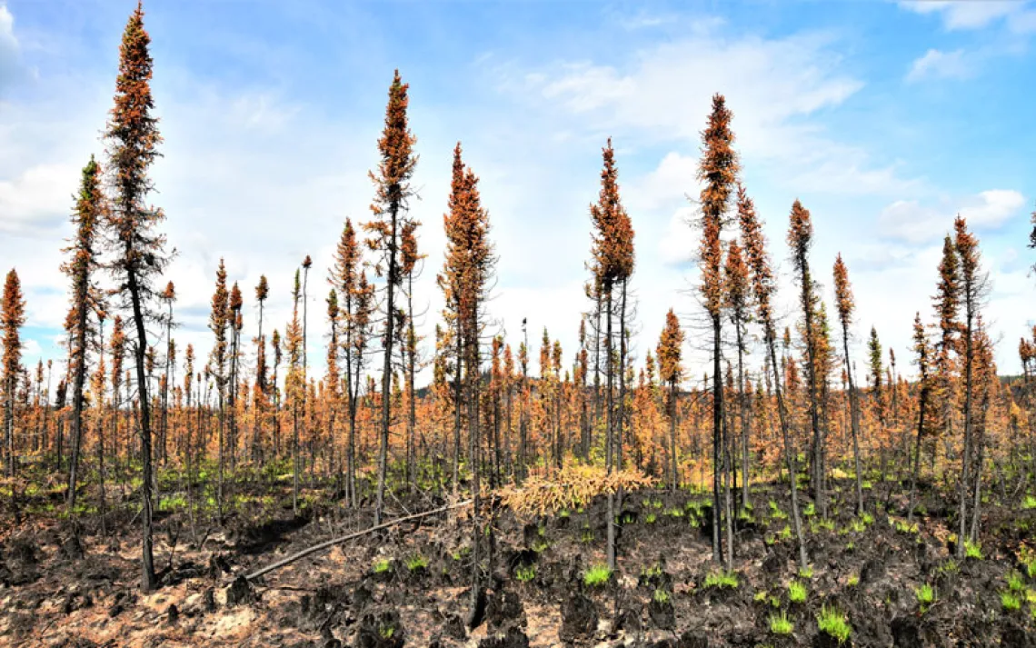
THE GHOST ROLLS IN somewhere near the edge of the Nebraska Sandhills. By the time I hit Ainsworth, the grassy dunes are cloaked in a gossamer shawl, and the cattle, the cottonwoods, the cattails—they're all blurry silhouettes. The sky is white, but the sun is missing, and when my throat starts to itch, I realize it's not some strange prelude to a summer storm but smoke drifting more than 700 miles south from wildfires in Canada—a strange prelude of its own.
The smoke persists the next morning as Nick Nemec, soft-spoken and graying at the temples, drives me around his 5,900-acre farm near tiny Holabird, South Dakota. Ten minutes after veering from the highway, he slows the pickup to a crawl. A light rain blurs the windshield, and a small herd of antelope ambles through the mist.
"So right now we're five miles from the highway," he says, "and it's the first native grass we've come to."
He's watched what he calls an "Iowa mix" of corn and soybeans creep farther west, thanks to no-till farming and drought-resistant GMOs. But few changes have been as obvious out here in central South Dakota, Nemec says, as the "plow out" of native prairie, the wholesale transformation of the grasslands he grew up with. And if the climate boundary is indeed moving east, he says, there may come a time when the GMOs can't keep up, when all these fields are replanted with native grasses and returned to cattle country.
Nemec pulls off the road 10 miles later, opens a gate, and drives into a sloping pasture stippled with black-eyed Susans. We pass a herd of black cattle and drive up to a shallow lake teeming with pelicans. If he's seen anything in his lifetime that testifies to the increasing variability of climate change, he tells me, it's this intermittent lake. In 1997, it filled with six feet of water after an especially wet winter. Only once in the previous 70 years had it risen even half that high, he says. But since then, it's hit that six-foot marker four times, while often vanishing entirely in the years between. The more he discusses the land—the knowledge passed from one generation to the next, the language of the prairie itself—the longer he pauses, the more his voice cracks. Finally he stops altogether and lets the breeze rush past him.
"I'm a son of the prairie," he tells me back in the pickup. "And I've admittedly benefited from the US government's crooked deals with the Great Sioux Nation, but my family has been here since the first homestead. It's not the magnificent, awe-inspiring beauty of, say, the Rocky Mountains. It's a much more subtle beauty that you gain an appreciation for by just slowing down, you know, and observing it."
He pauses again.
"It's just. . . . It's different."
I MAKE IT TO BISMARCK, North Dakota, later that evening and pitch my tent in General Sibley Park, just a few hundred yards off the Missouri River. The heat has finally subsided, the smoke has finally cleared, and I'm content at last to rest, to sleep late, to casually drift toward Fargo, my final destination. Just as I'm beginning to fade, however, I receive a text from Dakota Goodhouse, a Native American studies professor at nearby United Tribes Technical College. A friend of a mutual friend had spread word of my travels. "Hi. Sure," he writes. "When and where?"
Sporting a faded Flash Gordon T-shirt and smart wire frames, Goodhouse pulls up to my campsite around 10 the next morning. Unbeknownst to me, it's the anniversary of the Apple Creek Fight, a little-known battle instigated by the park's namesake in 1863. General Sibley and 2,200 soldiers chased thousands of Dakota and Lakota people west from the pothole lakes region and finally across the Missouri River at its juncture with Apple Creek, less than two miles from where we sit. But Sibley's forces couldn't topple the 500 Sioux warriors defending the bluff above.
"Sibley's letters, his officers' letters—they all minimized this conflict because it was a loss. This was the first interaction that Sitting Bull and the Lakota people had with soldiers and settlers. . . . And so the United States made an enemy where there was none."
An enrolled member of the Standing Rock Sioux Tribe, Goodhouse has petitioned the Army Corps of Engineers to rename the park, suggesting Thorn Apple or Little Apple instead—a more direct translation of the tributary's original Sioux name, derived from the fruit that once thrived on its banks. And it's this notion of language, how it binds the Sioux to their environment, he says, and to the resources found here, that pulls me back to the present, reminds me again why I'm sitting here on the 100th meridian—why I've traveled roughly 2,000 miles through the heart of the Plains. As a result of climate change, he tells me, those resources are shifting.
"Where we used to gather prairie turnips in mid-June, people are now gathering prairie turnips in the last week of May," he says. "We refer to July as the strawberry moon. When was the wild strawberry available for us to harvest [this year]? Last month. June."
It's thrown off their traditional calendars, he says. Their winter counts too. And because he creates both himself, he's now forced to look ahead, to play climatologist.
"If I get to November and call it the first winter moon, and there's no snow, it's not a winter moon anymore. So what is it?"
As we talk, towering cottonwood trees whisper above us, a million leaves shimmering like hungry minnows in the water. For a minute, we both fall silent, and suddenly I'm thinking of Nemec again, of those long pauses at the lake and his obvious affinity for the grasslands in retreat. Sister Jane in Kansas, too, and her quiet contemplation. I'm thinking of Professor Gabler monitoring the mudflats, Professor Basara finding patterns in all the chaos. How rare their attitudes seemed to be out here, how refreshing their attention to the landscape, the messages encoded within. Goodhouse mentions the wind—just the wind—how it supposedly drove so many white settlers insane.
"No Native person I've ever heard of has ever been driven insane by the wind."
It all makes me wonder how many signs we've missed out here by divorcing ourselves from that relationship, by strong-arming the landscape: damming the rivers, plowing the grasslands, even imposing a foreign language on the Plains. How we've made an enemy where there was none.
This article appeared in the Winter quarterly edition with the headline "The 100th Meridian Is on the Loose."