Desert Ruins
In the US-Mexico borderlands, Customs and Border Protection continues to harm the desert wilderness
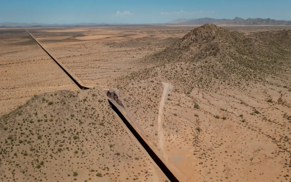
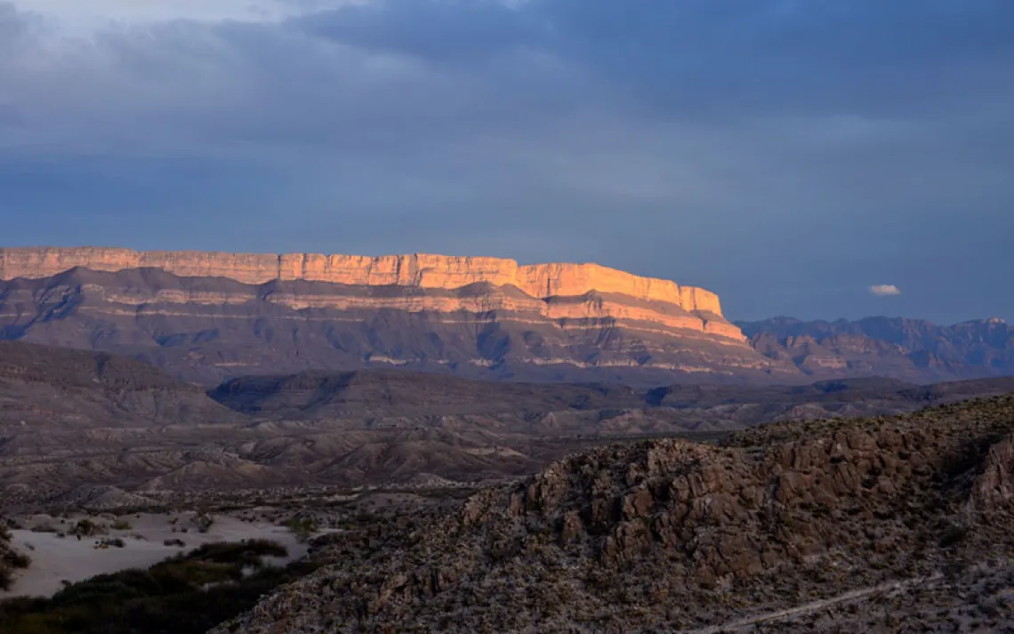
The border wall in Cabeza Prieta National Wildlife Refuge. | Photo by Bill Hatcher-Aerial support provided by LightHawk

IN THE EARLY 1990s, Rick and Sandy Martynec started conducting archaeological surveys in Arizona's Cabeza Prieta National Wildlife Refuge, one of the largest protected landscapes in the United States. Their research focused on an area called Las Playas, a series of dry lake beds that straddle the US-Mexico border. There, on both sides of the international boundary, they uncovered more than 150 archaeological sites, some with artifacts dating back 10,000 years, including jewelry made of polished shells from the Sea of Cortez.
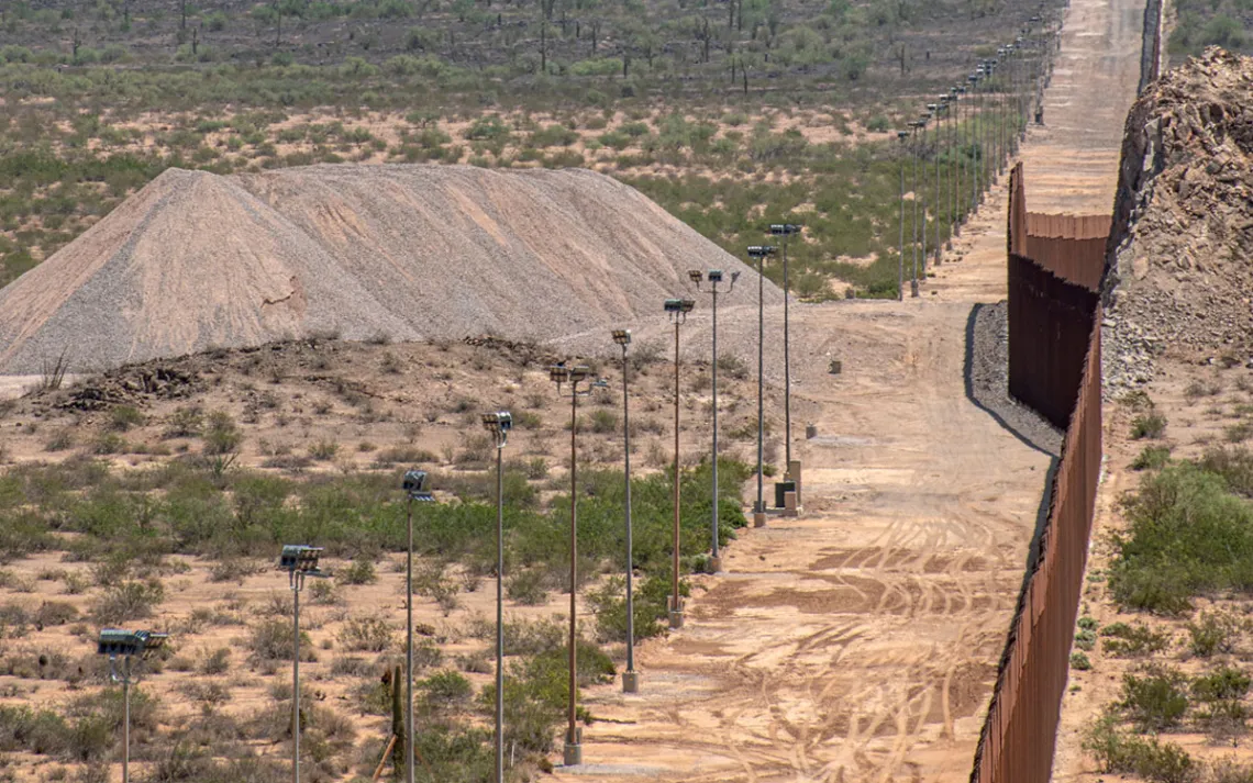
Another section of the wall in Cabeza Prieta with its support road and lights. | Photo by Bill Hatcher-Aerial support provided by LightHawk
Before border fencing and walls were put in place, most of them over the past 20 years, the area was rich in cultural and ecological exchange. Rick and Sandy could walk back and forth across the border and would sometimes cross into Mexico to have dinner or camp overnight. It drove the US Border Patrol agents nuts, but there wasn't much they could do about it. Plant and animal life also flourished, largely owing to the reliable presence of water, which replenished the lake beds and underground aquifers. Along with the Sonoyta River, which flows near the playas, summer and winter monsoon rains have long served to support riparian environments key to the survival of life in the desert.
But in the past couple of decades, the water resources near Las Playas have been diverted or obstructed by roads, dams, industrial agriculture, and the latest version of the border wall. On the US side, 9/11 ushered in a new wave of border infrastructure projects—walls, roads, and surveillance towers—as Congress granted the Department of Homeland Security (DHS) extraordinary powers to circumvent key environmental laws including the National Environmental Policy Act and the Endangered Species Act. The playas are no longer the oasis they once were. Dozens of unauthorized roads and the border wall have permanently altered the movement of water across the landscape. By the mid-2000s, Rick said, "We seldom ever saw more than a puddle or two in the playas. It was pretty much gone." In August, the Martynecs took me to the top of a hill overlooking the area and said they'd never seen it so dry. It had rained recently, and a small, meager-looking puddle near where we parked was full of tadpoles, evidence that where there is water in the desert, life will emerge.
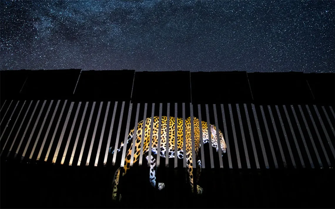
Since the Trump administration began border wall construction in 2018, millions of gallons of water from underground aquifers have been pumped to make concrete foundations for the new steel wall, further straining the ecosystem. Plant life has withered. Animal sightings are far less frequent. Bighorn sheep, pronghorn, Mexican gray wolves, and jaguars all move north to south, often following waterways or seasonal washes as part of migration corridors, and now some of those routes are barred. "We know very well that the majority of rivers have their headwaters in Mexico and flow north into the US," said Ben Wilder, a conservation biologist and former director of the University of Arizona's Desert Lab. "The line of migrations and connections are north-south. So when you draw this arbitrary line east-west, it's counter to everything."
Just before the wall went up, Rick and Sandy saw a group of three pronghorn wandering into Mexico—something they believe they may never witness again. Those passageways are now blocked to all but the smallest creatures. "Wherever that wall is up, that's the end of any kind of migratory movement," said Diana Hadley, founding president of the Northern Jaguar Project.
Cabeza Prieta is one of the largest wilderness areas outside Alaska—at least on paper. Originally established as a game reserve in the 1930s, it now comprises more than 860,000 acres of desert scrub and isolated mountain valleys. It is home to hundreds of endemic plant and animal species, including endangered Sonoran pronghorn and the lesser long-nosed bat, which is the primary pollinator of the night-blooming saguaro cactus. At least 600 archaeological sites have been identified within the refuge, some with pre-Columbian artifacts; most likely there are others yet to be discovered and inventoried.
Along with neighboring Organ Pipe Cactus National Monument, managed by the National Park Service, and the El Pinacate and Alto Golfo de California biosphere reserves in Mexico, Cabeza is part of "the largest contiguous protected area of any desert lands in the world," according to Wilder. In 1990, with the passage of the Arizona Desert Wilderness Act, more than 90 percent of the refuge was set aside as wilderness, the highest level of land protection in the United States. Motorized vehicles are prohibited. Bicycles and drones are forbidden. Except the rules don't apply to Customs and Border Protection (CBP) agents. The lands protection bill included sweeping language exempting the agency from any restrictions on its activities.
In the decades since, border militarization and extensive off-road-vehicle activity have left the desert deeply fragmented. In 2011, the Fish and Wildlife Service estimated that nearly 8,000 miles of vehicle trails had been created in Cabeza Prieta by Border Patrol agents and smugglers during the first decade of the 2000s. According to Freedom of Information Act (FOIA) records obtained by Type Investigations and Sierra, Border Patrol agents continue to make thousands of off-road-vehicle incursions into wilderness areas every year. This despite an agreement between DHS and land management agencies designed to reduce off-road-vehicle activity in the region. Meanwhile, new roads built to facilitate border wall construction have led to further degradation of the habitat. Jim Malusa, a botanist at the University of Arizona who has walked across Cabeza Prieta and recently published a vegetation map of the refuge, said nearly every corner of the desert has been impacted by CBP. "Over the last decade, they have literally driven everywhere that is not a mountain," he told me.

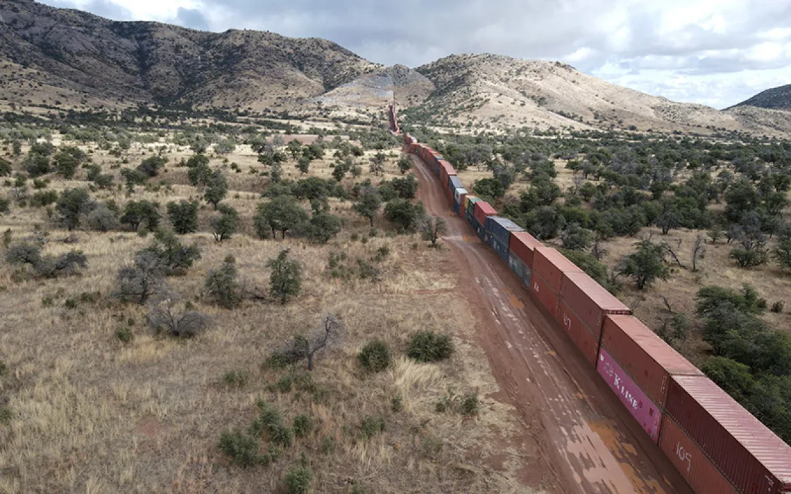
In the Coronado National Forest west of Nogales, Arizona, border wall construction has led to the removal of a mountaintop and a string of access roads. | Photo by Bill Hatcher-Aerial support provided by LightHawk
On his first day in office, President Joe Biden paused all border wall construction projects and revoked the emergency orders put in place under the Trump administration. "Building a massive wall that spans the entire southern border is not a serious policy solution," Biden said. "It is a waste of money that diverts attention from genuine threats to our homeland security." But his administration has had little to say about the deepening ecological crisis in the borderlands. Land management agencies remain woefully understaffed and ill-equipped to meet even basic needs. Cabeza Prieta has a budget for fewer than 10 full-time employees. The Fish and Wildlife Service has only two cultural resource specialists for the entire four-state region of Utah, Colorado, New Mexico, and Arizona. The Department of the Interior—which includes the Fish and Wildlife Service, National Park Service, and Bureau of Land Management—oversees over 600 miles of land along the border.
In November 2021, dozens of environmental and border justice groups called on Interior Secretary Deb Haaland to take a more active role in addressing ongoing environmental impacts on these lands. But the Department of the Interior remains outmuscled and overshadowed by CBP. Cabeza Prieta, according to an Interior Department employee who asked not to be identified, can barely meet its operational needs. "We know that wilderness, along with the rest of the refuge, is being slowly degraded," the employee told me. "And we'd like to do more but feel our hands are tied by the strength and the mission of Customs and Border Protection."
CBP, which has its own environmental protection specialists and public lands liaisons, says it works closely with the land management agencies. Charles Trost, the public lands liaison for the Tucson Sector, said that in the past 15 years the agency has helped restore some portions of habitat in Cabeza Prieta and Organ Pipe. "We're accomplishing it together," Trost told me. "We've been able to decrease the fragmentation of the area, so it increases the critical habitat available for endangered species and wildlife."
For its part, the Interior Department has been reluctant to discuss the challenges it faces managing public lands in the region, and how border security has affected cultural and environmental resources. Three days before I arrived at the border, the Fish and Wildlife Service denied my request to meet with Rijk Morawe, Cabeza Prieta's newly appointed refuge manager. A former natural resource specialist at Organ Pipe, Morawe had been keen to join the Martynecs to visit archaeological sites that, if you're not traveling on foot, are accessible only with a government vehicle. "If it's covering the refuge as an ecosystem, conservation principles implemented, opportunities for recreation, etc. and doesn't involve the politics of border issues, we should be good to go," he wrote in an email on August 1, acknowledging that he still needed to receive formal approval. Our plan was to leave early on August 16, a Tuesday. But the Friday before, at 5 p.m., the regional office sent me an email saying it wasn't going to happen.
In an accompanying statement attributed to Morawe, the agency said that the Fish and Wildlife Service and CBP had a "close and dynamic working relationship. . . . This ongoing partnership has allowed us to address operational needs while improving environmental conditions and preserving the wilderness character of the refuge."
The regional office said Morawe would not be available to be interviewed, but a few days later, I bumped into him outside the refuge office. It was 8 a.m., and the visitor center had just opened.
"I don't need to tell you anything," he said, visibly disappointed with what had happened and suggesting that I likely understood the dynamics at play. "We are working with Border Patrol," he said. "Trying to improve our relationship. And get back to where we were before."
ALTHOUGH BORDER PATROL has operated along the southern border for nearly a century, CBP underwent dramatic growth after the attacks of September 11, 2001. Two years later, as part of a larger reorganization, Border Patrol came under the jurisdiction of the newly created DHS (it had previously been part of the Immigration and Naturalization Service under the Department of Justice). The George W. Bush administration, with overwhelming bipartisan support, began scaling up funding for its parent agency, Customs and Border Protection. According to CBP data, the agency's budget has tripled over the past two decades, from $5.9 billion in 2003 to $17.7 billion in 2021. During roughly the same period, the number of agents stationed along the southern border increased from 9,840 in 2003 to 16,878 in 2020. (The Fish and Wildlife Service budget remains a fraction of CBP's. Funding for the agency, which manages 568 refuges across the country, increased from $1.9 billion in 2003 to $3.2 billion last year.) The passage of the Real ID Act in 2005, which set national standards for state-issued driver's licenses, also gave the DHS secretary the authority to waive all legal requirements so as to "ensure expeditious construction of the barriers and roads" along the border. That law, which received unanimous support in the Senate, allows DHS to act unilaterally when it comes to all border construction projects. The agency can now bypass all environmental laws and measures designed to protect cultural and historic resources, which typically require consultation with land management agencies.
The Bush administration's DHS secretary, Michael Chertoff, made quick use of the agency's new powers to fortify the border, installing hundreds of miles of pedestrian fencing and vehicle barriers in California, Arizona, and Texas. Starting in the mid-1990s and ramping up after 2001, CBP extended its reach into areas that had traditionally been the province of the Department of the Interior and US Forest Service, which each have their own law-enforcement units. At that time, cross-border migration routes were shifting, the result of a Clinton-era policy known as "prevention through deterrence," which aimed to crack down on illegal crossings in border cities like El Paso, Texas, and Nogales, Arizona. This had the effect—which federal officials intended—of driving immigrants into more remote and dangerous areas of the desert.
The policy has led to a humanitarian crisis marked by a surge in immigrant deaths. Between 1999 and 2021, nearly 4,000 people died trying to cross into the United States from Mexico, according to the advocacy group Humane Borders. "People are dying everywhere," one CBP agent, who was not authorized to speak on the record, told me.
Today, the border security presence in Organ Pipe and Cabeza Prieta is inescapable. There's a checkpoint just before you enter Organ Pipe on Highway 85. Public access to roads and trails in both the park and refuge are marked with signs warning visitors of drug smuggling and illegal immigration—even though visitors rarely encounter either one. There are nine surveillance towers, what DHS calls a "virtual wall," in Cabeza Prieta and Organ Pipe. Under the Trump administration, roughly 450 miles of wall went up along the border, most of it replacing existing barriers. The wall—which is made of 30-foot steel bollards, four inches apart—now spans nearly the entire southern boundary of both Organ Pipe and Cabeza Prieta. A 60-foot-wide dirt road runs parallel to the wall.
One morning, I drove from Lukeville, on the border, west to the Organ Pipe–Cabeza Prieta boundary with Jesus Vasavilbaso, an agent and public affairs officer with CBP's Tucson Sector, and Eric Kirker, the Ajo Station's public lands liaison. After a few miles, we turned off the highway onto a public road that takes visitors past Quitobaquito Springs, one of the few permanent sources of water in the region that has been used by the Hia-Ced O'odham for thousands of years. We crossed an unfinished culvert and eventually made our way onto the road that parallels the wall.
The Tucson Sector, Vasavilbaso said, is responsible for patrolling 262 border miles, much of them on public lands, and makes thousands of apprehensions every month. "One of the different things here at Tucson Sector is that most of the people that we encounter do not want to be apprehended," he said. About 75 percent of those coming through the Tucson Sector, he noted, are single adults—as opposed to families or unaccompanied minors.
At one point, Vasavilbaso stopped the vehicle to show me one of the agency's "tactical infrastructure" routes, a road that cuts through federally designated wilderness and is used, according to CBP, only when agents have good reason to believe it will lead to an apprehension or rescue. An F-450 platform pickup with a camera and radar system stood watch on a nearby hill that had been blasted apart in 2020 to build a portion of the border wall, in the process destroying part of a sacred Tohono O'odham site.
According to Kirker, every agent has a digital map of the tactical infrastructure routes in wilderness areas. And each time they decide to use one of these roads, or to go off-road completely, they are required to fill out a report that includes details on when and where the agent entered wilderness, the reason for doing so, and whether they encountered pronghorn. (CBP declined to provide an estimate of the number of tactical infrastructure routes in Organ Pipe.) The documents are shared regularly with the land management agencies. This reporting system was established as part of a 2006 memorandum of understanding between DHS and the land management agencies, designed to improve inter-agency communication and reduce off-road-vehicle activity in wilderness areas along the border. According to the agreement, Border Patrol agents still have the authority to enter wilderness areas but only when, in their judgment, there is a "specific exigency/emergency involving human life, health, safety of persons within the area, or posing a threat to national security." Kirker told me, "We aren't just going to go and drive these routes for leisure. There has to be a legitimate law-enforcement reason to do so."
But according to the FOIA records obtained by Type Investigations and Sierra, Border Patrol agents continue to make frequent use of wilderness lands even when justification for doing so does not appear to meet the criteria laid out in the agreement. Between 2015 and 2018, there were more than 7,000 wilderness-incursion reports filed for Cabeza Prieta and Organ Pipe, with numbers remaining relatively consistent from the last two years of the Obama administration to the first two years of the Trump administration. The reports are heavily redacted, and explanations for why agents entered wilderness are broad and sometimes incoherent, with the most common reason being a version of "law-enforcement activity." Other explanations include "working traffic," "working a group," and "patrol the border." (More than 1,000 of the explanations were redacted to protect what under FOIA is considered sensitive law-enforcement information.)
Cyndi Tuell, an attorney with the Western Watersheds Project who reviewed the FOIA data, said many of the explanations are so vague that they appear to be outside the scope of the agreement, which requires specific reasons for incursions. Tuell said land management agencies should be demanding more information from CBP to hold the agency to account. Myles Traphagen, a borderlands coordinator with the Wildlands Network who also reviewed the FOIA documents, said the reports would be of limited value to land management agencies. "There's no methodology or consistent coding for collecting any of these data," he said. "Anybody who's really interested in border security and in increasing efficiency would see this is not money that's well spent."
CBP says it instructs agents to enter wilderness only if there's "reasonable certainty" that doing so will lead to an apprehension or rescue. But the agency doesn't keep track of whether the incursions lead to apprehensions, making it difficult to know how effective these off-road pursuits are. Trost, the public lands liaison, said the reports are designed to measure impacts to the environment and provide land management agencies with a general overview of CBP's activities along the border.
We finally reached Cabeza Prieta and walked along the road into the refuge. There was a section of braided rope hanging from the top of the border wall, likely a spot where immigrants had attempted to cross. According to Vasavilbaso, CBP is already seeing a shift in tactics on the part of human traffickers in response to the new wall. Immigrants are now traveling in smaller groups, which has the effect of requiring more agents to pursue multiple parties. This can spread the agency thin. It's also more difficult to track groups of two or three than it is a group of 20 or 30, which in the long run could lead to even more off-road-vehicle activity.
Vasavilbaso said the wall will ultimately reduce traffic in this part of the desert and that the new extra-wide road will make it easier for agents to access remote areas. But early data suggests that the wall is just one more obstacle for immigrants on what is an increasingly dangerous and often lethal journey. According to a report in The Washington Post, the new wall has been breached more than 3,000 times since 2019. Meanwhile, a growing body of global research has shown that border walls do little to stop the movement of people—they simply shift migratory routes—and tend to incentivize human smuggling. According to the Migration Policy Institute, an immigrant-rights think tank, "Walls end up producing more instability without solving the problems they were intended to address."
TRUMP'S WALL IS ONLY the latest chapter in a two-decade trend of border militarization, which has largely been a bipartisan project. The DHS secretary's authority to waive all laws along the border has been central to that effort and has made federal lands, including wilderness areas, especially attractive for border wall construction. Under the Trump administration, DHS expedited the contracting and building process as it sought to complete hundreds of miles of new and updated border wall before the end of 2020. Trump also declared a national emergency in a bid to divert funding from the Department of Defense for border construction projects. (The Sierra Club and the Southern Border Communities Coalition challenged the national emergency on constitutional grounds, but the Supreme Court dismissed the case after the Biden administration came into office.) According to a Government Accountability Office (GAO) report published last year, the US Army Corps of Engineers, which oversees infrastructure projects along the border, awarded more than $4 billion in noncompetitive contracts during this period and in many cases allowed work to begin before it had agreed on basic terms and conditions. To avoid delays associated with acquiring private land, DHS prioritized federal lands even if those areas were not considered to be a top priority in terms of border security.
Construction itself was marked by a general lack of oversight and accountability, according to conservation groups and members of the Tohono O'odham Nation. Videos circulated widely of saguaro cacti (a plant considered sacred to the Tohono O'odham) being bulldozed to accommodate the wall. According to CBP, thousands of cacti, including more than 700 saguaros, were relocated during the early stages of border wall construction. Sue Rutman, a former botanist at Organ Pipe from 1994 to 2013, said it is difficult to transplant cacti and that survival rates are low. Meanwhile, contractors were pumping thousands of gallons of water every day from desert aquifers, including one within eight miles of Quitobaquito Springs, which provides habitat for the endangered Sonoyta pupfish and Sonora mud turtle. The total quantity of water used by contractors is hard to pin down, and the Army Corps and CBP did not respond to requests for comment. (According to one estimate provided in 2019, CBP said contractors were using about 84,000 gallons of water a day in Organ Pipe to mix concrete for the wall.)
Sid Slone, who was refuge manager at Cabeza Prieta from 2009 to 2021, said there were eight wells on the refuge, including two near Las Playas, and that each provided about 2 million gallons of water for border wall construction. "They pumped quite a bit of water out," he said. "Some of the best we have in that area."
Monitoring of cultural sites, especially on federal land, was also inadequate, according to Peter Steere, a tribal preservation officer for the Tohono O'odham Nation. In one case, a contractor bulldozed a road through an archaic Hohokam burial site on the border in Coronado National Forest, despite being briefed by the tribe in advance. CBP also blasted through several hills that were too steep to build on directly, including one in Organ Pipe that was a well-known burial ground. "My colleagues at the Park Service, their hands were tied," Steere said. "I was told that basically the Border Patrol, to a large extent, ignored what the management agencies were recommending." A spokesperson for CBP did not respond to multiple requests for comment on the claims that the agency and its contractors had destroyed cultural sites, and that it had ignored the advice of the land management agencies.
In July, DHS announced that it would resume "border remediation efforts"—that is, completing parts of what the Trump administration started. The department said it would fill in some of the gaps in the border wall that were left when Biden took office as well as install new lighting and cameras in places where barriers already exist. Meanwhile, plans to build 86 miles of congressionally mandated border wall in Texas's Rio Grande Valley are moving forward.
The GAO is planning to release a report next spring looking at various sections of the wall, including portions in Cabeza Prieta and Organ Pipe, and the role land management agencies played in project planning and subsequent efforts to mitigate long-term impacts to natural and cultural resources. In a written statement, Organ Pipe said it had carried out pre- and postconstruction studies of night skies, natural sounds, wildlife, well monitoring, and archaeological sites but that the findings are not yet available. It has plans to begin evaluating impacts to surface water movement in the coming months. "US Customs and Border Protection and the National Park Service have a long history of cooperatively managing environmental resources," the statement said. "We will continue this collaborative work moving forward." Cabeza Prieta did not respond to requests for comment.
But Rick and Sandy Martynec are doubtful that these landscapes can be restored without first transforming the relationship between CBP and the land management agencies. They've avoided returning to Las Playas and Quitobaquito since the new wall went up. It's too painful, Rick said. During the Trump years, they spent a considerable amount of time and energy trying to protect a rare intaglio—a roughly 270-foot oval shape etched into the desert floor—and a burial site just south of the playas. The intaglio was likely used for ceremonial purposes and dates back more than a thousand years. But it extended into the section of new road that runs along the wall. The Martynecs and members of the Tohono O'odham Nation alerted the Army Corps and managed to preserve it. There are now several large boulders piled up around the edge of the intaglio. "It was kind of a success story," Rick told me. "We don't get enough of them."
There are other areas in Cabeza Prieta that the Martynecs would like to survey, but it's unclear if the refuge will have the resources or interest in contracting with them. One spot is about six miles north of Las Playas, where CBP has bulldozed a road that connects two remote Border Patrol outposts. Even refuge staff cannot access this road. Rick and Sandy have hiked back into the area a couple of times and observed pottery, stone tools, and shell jewelry as well as evidence of hunting and possibly agriculture. Those artifacts have been churned up by construction and Border Patrol activity, Rick told me. "We know for a fact that Border Patrol went through archaeological sites out there."
What else has already been destroyed in the desert, the Martynecs say, no one knows.