The Fate of 23.8 Million Acres of Arctic Wilderness Is in Jeopardy
1.5 million acres were leased for oil in 2019—with more planned in the future
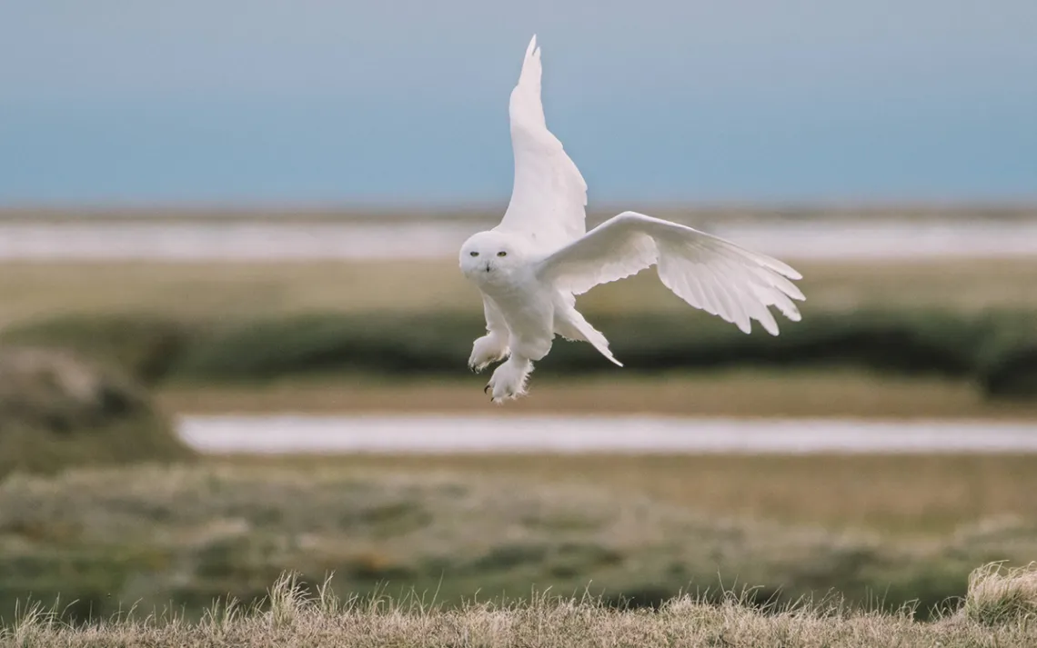
A male snowy owl in search of lemmings. It's a lemming bumper crop year on Alaska's North Slope, and snowy owls are busy feeding their families alongside millions of other nesting birds.
|Photos courtesy of Kiliii Yüyan
We landed in the 23.8-million-acre National Petroleum Reserve in Alaska hoping to see the biggest, wildest, remotest place in the United States. My fellow adventurers and I didn’t want to see oil derricks and pipelines; we’d seen plenty of those. What we saw as we flew in to land beside a tributary of the Colville River were castellated mountains and winding rivers. Floating down the Colville, we watched grizzly bears prowling, herds of caribou strolling along treeless hills, moose moving slowly across the tundra, and peregrine falcons perched on cliffside nests feeding their young. Loons, arctic terns, sandpipers, and jaegers flew around a campsite that became nearly flooded by high waters. Archaeological sites showed centuries' worth of evidence of Inupiat settlement. I had hoped to experience this vastness, a place as wild as wild can be, once in my life. And it did not disappoint.
There's a reason the NPRA, also known as the Arctic Reserve, topped my bucket list. In December, a newly formed company called North Slope Exploration leased 1 million acres from the Bureau of Land Management to explore and develop Arctic Reserve land for oil. This added to the 1.4 million acres that are already wide-open to development. According to a November 2019 BLM environmental impact statement (EIS), the Trump administration is poised to further reduce protections for the NPRA and offer more tracts for additional oil development.
The NPRA lies to the west of the Trans-Alaska Pipeline, which is flanked on its east by the 19-million-acre Arctic National Wildlife Refuge. Alaska's Arctic ecosystem includes the Brooks Range, which runs east and west, with dozens of rivers running north to the Arctic Ocean. This area is roughly 67,188 square miles, larger than New York State, and marked by a spectacular geography of mountains and coastal flats.
The BLM's most recent EIS on the fate of the Arctic Reserve effectively outlines two choices: maintain this wilderness habitat or develop a big part of it for oil—the latter would likely see its 23.8 million acres diced into smaller pieces divided by roads and development. “It was prudent,” said Alaska’s state BLM director Chad Padgett, “to develop a new plan that provides greater economic development of our resources while still providing protections for important resources and subsistence access.”
What may have been most “prudent,” in Padgett's parlance, was US Geological Survey scientists’ 2017 discovery of 8.7 billion barrels of oil within this reserve. The proposed “exploration and development" stands to further exacerbate thumbprints of climate change in the vulnerable Arctic, and threatens much of this landscape's abundant wildlife. In any case, it will determine the future of the largest piece of public land in the country.
Further oil exploration would particularly heighten already-intensive conflict around the 3.65-million-acre Teshekpuk Lake special area (see below sidebar for more on threatened areas) and its globally significant bird population. Federal BLM assistant secretary of land and minerals management Joe Balash stated last year that geologists view the area as “extremely prospective.” He said, “The big question is, can we make some of that acreage available in a manner that is responsible and honors the subsistence way of life that the people who live in the NPRA have lived for thousands of years?” But then in December, North Slope Exploration purchased 83 oil leases, each roughly 11,000 acres, southwest of Teshekpuk Lake.
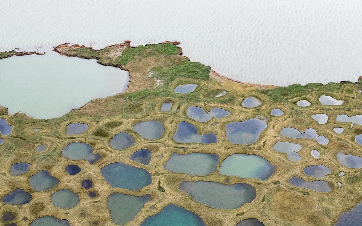
Tundra polygons at the Qupaluk marshlands in the Arctic Reserve. They're shaped by thousand-year-old freezing and thawing forces, plus an underlying permafrost layer. These polygons make for excellent bird-nesting areas, as they create small shallow lakes surrounding dry ground.
"It's a chess game of incremental moves," says Susan Culliney, policy director for Audubon Alaska, who adds that the new EIS puts some of the most vulnerable places in the entire reserve at heightened risk. "This is how places get developed—it's slow and steady, a spiderweb of development." Another concern for this ecosystem is the increase in global warming, perhaps most pronounced in Arctic regions. The precise environmental effects will depend on where oil is found and how sensitively it is extracted, pumped, and piped to the Trans-Alaska Pipeline—as well as on the condition of melting permafrost.
The National Petroleum Reserve in Alaska is bound by its name. In 1923, only four years after WWI’s end, President Warren Harding designated, by executive order, this vast block of public land as an emergency fuel supply for the military. Since then, however, the reserve had seldom been used as a military supply source. In 1977, Secretary of the Interior Cecil Andrus established three protected “special areas” under the authority of the 1976 Naval Petroleum Reserves Production Act: Teshkpuk Lake, Utukok River Uplands, and the Colville River. This law also allowed for “significant subsistence, recreational, fish and wildlife, and historical or scenic values” to be set aside for “maximum protection.” And it balanced those conservation measures with oil exploration elsewhere in the reserve. In 2004, Interior Secretary Gayle Norton added 97,000 acres of Kasegaluk Lagoon as another special area to maintain populations of beluga whales, walrus, seals, and polar bears.
The reserve presently includes hundreds of miles, from the Colville River to the Arctic Ocean, of undisturbed habitat for many thousands of waterfowl—like king eider ducks, tundra swans, and white-fronted geese—on hundreds of ponds and lakes. What some might call barren ground provides homes for grizzly and polar bears, wolverines, arctic foxes, and musk oxen. According to Rebecca McGuire, avian ecologist for the Wildlife Conservation Society, the Arctic coastal plain boasts higher species diversity and density of breeding birds than anywhere else in the circumpolar north. “The NPRA is the most important part of the arctic coastal plain for breeding birds.
Peregrine falcons, classified as endangered 50 years ago, enjoy excellent habitat there, with little pollution and good breeding terrain on the cliffs of the Colville River. This fueled their recovery to hundreds of mating pairs in Alaska—in 1999, US Fish and Wildlife removed them from the endangered species list. Rare migratory waterfowl and shorebirds flock to the reserve every summer. Musk oxen, too, reintroduced a few years back, once again thrive in the reserve.
Pure wilderness may be the reserve's most defining characteristic, but it's also home to Native Americans—Inupiat villages have existed within the reserve for as long as anyone remembers. Forty years ago, an Inupiat spokesperson sent a document to the secretary of interior. “The Inupiat View” served to demand “free access and use of the homeland by Inupiat villagers; strict protection of the homeland’s physical, biological, and cultural environment; [and to provide] the highest possible degree of home rule and management control of the homeland by the Inupiat.” In addition, the document states, “National energy needs should not be transposed into a general exploitive policy.… [and] Development for oil and gas development should be areally compact and carefully staged to avoid environmental and social overload.” In return, the Inupiat received a “statutory framework” from the US government promising to meet those requests.
But that framework has sprung leaks under the pressure of additional oil profits and an oil-development-happy administration. Today, the Inupiat have divergent opinions within the community—with some opposing oil development and others supporting it—but even so, they are in agreement when it comes to the topic of maintaining their subsistence style of living. The town of Nuiqsut, for instance, is home to 425 inhabitants living in close proximity to the oil development that supports them economically; however, their wild surrounds afford them essential opportunities to hunt for caribou and whales.
According to a 2017 report from the University of Alaska, McDowell Group, 2 million barrels of oil were produced at Prudhoe Bay in 1977, and 12 years later, 500 million. "Today we are at one-quarter of that capacity (of 500 million barrels). That is the way of most industries.” This pattern of depletion seems to be behind Alaska senator Lisa Murkowski’s urgency to drill. Addressing the Alaska Oil and Gas Association in 2018, the Republican stated, "We have to make sure that drilling will protect the environment and protect the wildlife and protect the land. That is our responsibility. But we will also have to be relentless."
ConocoPhillips, Alaska’s largest oil developer, has holdings in lease units in the North Slope of Alaska including Kuparuk, Alpine, Mooses Tooth 1 & 2, Bear Tooth, Willow, and West Willow. The company also holds 733,000 acres of undeveloped land within the reserve. ConocoPhillips acquired 48,000 of those acres in the NPRA’s 2018 lease sale, and another 33,149 in 2019. It now has virtual ownership of 1.2 million acres within the reserve, according to company information. In 2019 the oil company claimed to be “a model for future developments," thanks to “directional drilling, zero harmful discharge, and other innovations to minimize the environmental footprint on the Arctic.” In addition to a diminished footprint, ConocoPhillips stated that the newer development allows for greater efficiency, as fracking and directional drilling have resulted in 80 percent increases in Alaskan oil production from 2008 to 2015.
“Teshekpuk Lake should remain protected,” Daren Beaudo, a spokesman for ConocoPhillips says, adding, “Other areas south of the lake that are currently unavailable for leasing could be made available for leasing without significant impact.” Some of ConocoPhillips’s conservation practices have included reducing the size of each gravel pad for drilling, from 65 acres in 1970 to 12 acres today, and using more drills in a single place to assure access to a larger area. In 1970, each drill pad drew from three square miles in an underground pool of oil, and in 2019 ConocoPhillips predicted that five drills, aimed diagonally from the pad, will grant drillers access to 154 square miles.
The current EIS defines four alternatives for the public to comment upon: Alt A states the no-action alternative to retain current conditions; Alt B reduces the protected area in the Teshekpuk Special Area by 4 million acres and maintains all other special areas; Alt C increases the land that is unprotected to 17.1 million acres (this identifies the core area around Teshekpuk Lake as unavailable for oil leasing); Alt D increases the land available for leasing to 18.3 million acres including the entire Teshekpuk area and parts of Utukok River Uplands Special Area.
Each of these alternatives will reduce the limited protection of the special areas in different ways, as they're compromises that increase the acreage available for oil production. The BLM EIS will likely meet the desires of oil developers unless citizens offer their commentary to protect the Colville River special area and add protection to the reserve’s other special areas (Utukok Uplands, Teshekpuk Lake, Peard Bay, and Kasegaluk Lagoon), and the health and well-being of the Inupiat. The comment period will run until January 21, 2020.
Whatever the resulting decision, it revisits one made in 2013 that decreed 11.8 million acres of the reserve open for oil development and designated 12 million acres off-limits, to protect vulnerable wildlife. Regardless, all action alternatives in the 2019 EIS eliminate the Colville River special area’s protection, which means that the 2.44 million acres (3,813 square miles) in the Colville drainage will not be offered any protection at all, and may be opened up to gravel mining.
I'm glad I got to experience the wild beauty of the NPRA before roads are built from the pipeline to the lease sites, before oil is developed around Teshekpuk Lake, before more drilling pads are developed and rock for roads to access them is mined from the Colville River drainage. Of course, that's a worst-case speculation. Ideally, the two existing lawsuits (see sidebar) against the federal government over the BLM's approval of ConocoPhillips’s exploratory drilling plan will delay development, and the BLM will take EIS commenters seriously.
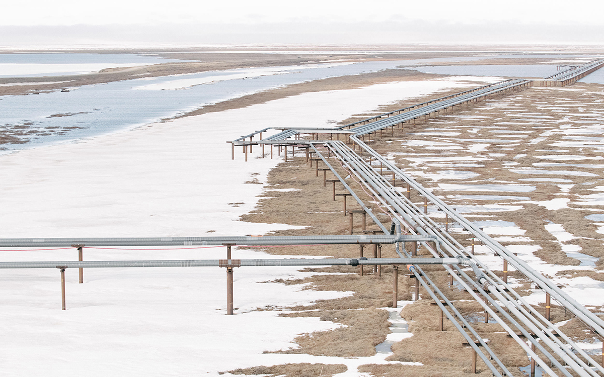
An oil pipeline outside of the village of Nuiqsut, Alaska. Precisely because the tundra is featureless over such a huge area, pipelines and roads in the wetland region of Teshekpuk Lake would grant predators height, and thus access to nesting migratory birds.
Each of the following five special areas were designated to protect certain values as policy in an environmental impact statement.*
The Utukok River Uplands include more than 4 million acres, constituting the largest protected area in the NPRA. It contains calving grounds and insect relief for the nearly 230,000-member Western Caribou Herd (the largest in Alaska) and supports the highest concentration of grizzly bears in the Arctic. It includes large populations of wolves, wolverines, and moose. The Utukok River travels 225 miles to the Kasegaluk Lagoon and the Chuckchi Sea. Many small villages above the Arctic Circle depend on the Western Arctic Caribou herd for subsistence, while others depend almost entirely upon oil production jobs and production.
At 3.65 million acres, Teshekpuk Lake and its surrounding wetlands provide a seasonal home for many species of waterfowl: threatened spectacled and king eiders, yellow billed loons, dunlins, several varieties of geese, and others are dependent on these wetlands. The wetlands also provide habitat for the 45,000 Teshekuk caribou herd as they migrate. The eastern portion of Teshekpuk Lake is being hotly pursued by ConocoPhillips for oil exploration and production, and this protected area is being considered as open for oil exploration in the 2019 EIS. This is seen by many as the most threatened place in the reserve, and two lawsuits have been filed to stop the drilling.
One suit has been filed by Earthjustice on behalf of a coalition of environmental groups in opposition to oil and gas exploration and leasing in the reserve. That suit is joined by the Native village of Nuiqsut challenging the BLM's approval of ConocoPhillips's winter exploratory drilling program, including 70 miles of ice roads, 24 ice pads, and six new wells. This lawsuit asserts disturbance of the Teshekpuk caribou herd and subsistence uses of the reserve. The second lawsuit, filed by the Trustees for Alaska for a coalition of environmental groups, asserts that the BLM has failed to evaluate site-specific impacts of oil and gas development before the agency leased the land to ConocoPhillips. Environmental groups are also challenging the six leases that were granted in 2017.
The Colville River area consists of 2.44 million acres, with cliffs along the river that support critical hunting and nesting habitat for gyrfalcon, peregrine falcon, golden eagle, and rough-legged hawks. The river flows 391 miles through the drainage to the Beaufort Sea near the Inupiat town of Nuiqsut, and the area has a high wolf density. Here, grizzly bears, salmon, musk oxen, and caribou are hunted in a sustainable manner and, at the mouth to the Beaufort Sea, bowhead whales, seals, and polar bears are too.
ConocoPhillips has developed two new oilfields and has built a bridge over the river near Nuiqsut, opening this area for significant incremental oil production in the future. What could happen in the delta of the Colville River in case of an oil spill has not been discussed. In the 2019 EIS, the Colville River has been eliminated as a special area because the peregrine falcons have recovered. The EIS seems to emphasize the value of this river merely as a source of gravel to build roads across the reserve.
Peard Bay consists of 107,000 acres at the point between Wainwright and Barrow, and includes high densities of polar bears, ice seals, walrus, spectacled eider, and red phalarope, among other shorebirds. It also provides “haul-out” areas for ringed and bearded seals.
Kasegaluk Lagoon consists of 96,000 acres of wetland and water habitat supporting beluga whales, seals, walrus, and denning polar bears. This lagoon is said to be the largest undiminished coastal lagoon system in the world with its sheltered, shallow water and 125 miles of Chuckchi Sea coast. The area supports the highest diversity of birdlife of all Arctic Alaska’s coastal lagoons. Almost half of the world’s Pacific black brant rest in the Kasegaluk Lagoon. Beluga whales calve in its waters and up to 36,000 Pacific walrus’ haul out here. A pipeline route and a port development, already approved, could destroy much Kasegaluk habitat. The route has not been decided upon.
*Adapted from information supplied by the Alaska Wilderness League and Audubon