From Patoka to Cannonball
A journey up the Dakota Access Pipeline
Photos by Winifred Bird and Cyrene Krey
This week, as a bitterly cold winter storm swept through North Dakota, the state’s governor ordered the Standing Rock Sioux tribe and their thousands of supporters to immediately abandon their main camp on the banks of the Cannonball River in order to avoid exposure to the winter weather. There is little chance they will do so. The camp is the epicenter of the tribe’s actions to prevent Energy Transfer Partners from building an oil pipeline across their sacred lands and under the Missouri River, which supplies their reservation with water. To protect that water from the possibility of future pipeline ruptures, they have already withstood rubber bullets, tear gas, pepper spray, concussion grenades, mass arrests, and strip searches. Winter weather, the tribe’s leaders say, will not stop them.
Earlier last month, we traveled the length of the Dakota Access Pipeline, from its end point in Patoka, Illinois, to its contested crossing of the Missouri River 1,000 miles northwest. Our goal was to document what the men and women in Standing Rock are taking such extraordinary measures to protect. We interpreted that in the broadest terms: not only the stretch of river alongside the Standing Rock reservation that has been the immediate focus of recent actions, but also all bodies of water and communities, human or wild, that lie directly in the pipeline’s pathway, from the Bakken oil fields to Patoka, and will therefore be at risk of contamination should the project continue as planned. Indeed, one reason the self-described water protectors at Standing Rock have drawn so much global support is that they frame their struggle as both a specific one—for sovereignty over a particular place—and a universal one, for the value of water above oil and human well-being above profit. Along the length of the route, the pipeline directly crosses or runs alongside numerous creeks, marshes, ponds, and natural habitats of various sizes. Some of these waterways are so small as to register only a faint scratch on maps, but all bring life to the land.
—Winifred Bird and Cyrene Krey

Dawn at Smith Lake in west-central Illinois, where locals boat and fish. The pipeline grazes the northern tip of the lake before passing under the Illinois River. Over coffee in the riverside town of Meredosia a few miles north, a local hunter told us the project has drawn little criticism in the community, where jobs are scarce and even temporary construction work is welcome. “I don’t know what people will do when the pipeline work ends,” he said. Like many of the people we talked to along the way, he declined to give his name. [Photo: Cyrene Krey]

A flock of over 150 American white pelicans glided silently on the far side of the lake as the early-morning mist lifted. As aquatic birds that rely on freshwater lakes, rivers, and marshes for foraging, breeding, and migrating, pelicans are particularly dependent on clean bodies of water for survival. On the lake’s edge, dozens of ducks gathered around nesting islands made of hay bales. [Photo: Cyrene Krey]

Near Oskaloosa, Iowa, the pipeline weaves a narrow path between Lake Keomah State Park and Maskunky Marsh, an important migratory bird stopover, before crossing the South Skunk River and passing directly east of Russell Wildlife Area. In the last of the afternoon sun, a family of six—grandparents, mother, three kids—sat on the edge of this quarry pond in the reserve where they’ve come to fish for decades. “I don’t like it,” the mother, who identified herself only as Angela, told us when we asked what she thought of the pipeline. “It’s going through our water. We’ve got to live on this earth, and you can’t drink oil. I support what they’re doing up in North Dakota. But it’s already in the ground here. What can you do?” [Photo: Winifred Bird]

In Alta, Iowa, the pipeline traverses a wind farm, an important energy source in the state. As in many locations along our route, construction here was still underway (and extending into the night under brilliant floodlights) in early November, contradicting claims by Energy Transfer Partners that the pipeline was nearly complete aside from the segment near Standing Rock. Private security personnel hired by Energy Transfer Partners closely guard the construction sites. At one location, an off-duty police officer moonlighting as security called the state police on us for stopping our car along a public road adjacent to the construction work. [Photo: Cyrene Krey]

Many Native Americans refer to the pipeline as the “black snake,” in reference to a Lakota prophecy. Passing Winfred, South Dakota, population 52, the freshly turned earth covering a segment of pipeline called that image vividly to mind. A few miles away, the pipeline crosses a creek that waters livestock and wildlife. Although it does not intersect any major bodies of water in the state, the pipeline passes or bisects numerous small streams and ponds that play a vital ecological role in the dry landscape. [Photo: Winifred Bird]

As dawn broke over the Missouri River about an hour south of the Standing Rock reservation, a beaver poked her sleek head above the water’s surface and paddled toward the shore of the cove where we stood, seemingly unconcerned by our intrusion into her world. Continuing toward Standing Rock through the undulating hills that line the river, our car sent white-tailed deer and broods of pheasants trotting hurriedly off the road. Despite extensive channelization and dams that have reduced fish populations, the Missouri is still home to abundant wildlife, including endangered interior least terns and pallid sturgeon. [Photo: Winifred Bird]

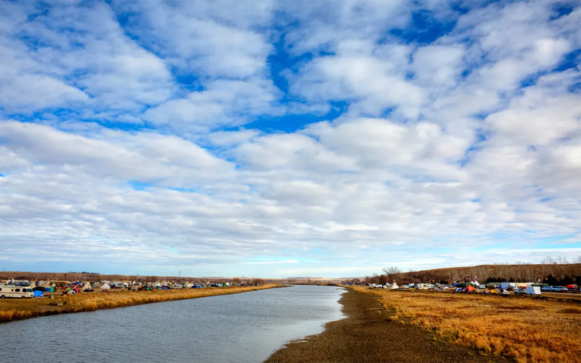
Water protectors camp along the banks of the Cannonball River where it empties into the Missouri. To the north lies the federal land that North Dakota’s governor has ordered evacuated; to the south is private land belonging to the Standing Rock Sioux Reservation. The adjacent section of the Missouri is part of Lake Oahe, the fourth-largest reservoir in the United States. It formed in the 1960s after the Army Corps of Engineers built a hydroelectric dam nearly 200 miles to the south, flooding thousands of acres of tribal farmland, forest, and towns and continuing a long history of conflict over rights to water and land in the state. [Photo: Cyrene Krey]