The Landslide at the End of the Trail
On witnessing the birth of a Wyoming lake—and watching it grow up
Photos courtesy of Dina Mishev
I had no idea what or where Crystal Peak was until after its north face started falling off. Located on the east side of Jackson Hole, within the Gros Ventre Wilderness of the greater Bridger-Teton National Forest, this mountain—along with the rest of its range, the Gros Ventre (pronounced gro-VONTS) Mountains—is in the unfortunate position of competing with the Tetons. The latter, protected by Grand Teton National Park, rise snaggly and steeply about 15 miles to the west of the Gros.
The Gros Ventres’ marquee mountains are Jackson Peak and Sleeping Indian (officially Sheep Mountain). The former has a pyramidal summit you can pick out from the highway that runs into Jackson, and the latter requires just a bit of imagination to make out a Native American wearing a headdress and lying on his back with his arms crossed across his chest. Crystal Peak is buried deep within the range, has a summit of no superlative height (10,972 feet), and is difficult to see unless you’re already in close proximity.
The visitors who do come to the area—usually adventurous anglers and hunters—do so not for the mountain, but for nearby Crystal Creek, home to trophy-size trout and feeding a designated National Wild and Scenic River. In the past, it burbled bucolically through meadows of lush grasses, beneath the peak’s north face, and alongside wildflowers including silky fusilier, columbine, Indian paintbrush, and lupine. As recently as 2006, you could camp in these meadows and barely notice Crystal Peak.
But in 2014, the first time I was back in its vicinity, I hiked around a corner, about four miles from the trailhead, and saw it. There was no missing this mountain, because half of it was missing. Literally. Much of the top half of the peak’s north face had collapsed. The mountain was an open wound.
The BTNF personnel had long known about its cause—a small land movement near Crystal Peak’s summit. “It happened a long time ago and was insignificant,” said BTNF North Ranger District Recreation Supervisor Linda Merigliano. In 2007, it graduated from insignificant to the largest land movement in the state of Wyoming in the past decade. That year, bus- and truck-size boulders, pine and aspen trees, silt, dirt, mud and anything else in their way tore down the mountainside, stopping only when the mass slammed into the valley floor, which buckled and crumpled under the force.
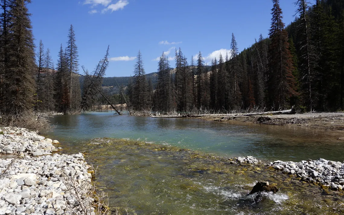
By the time I made it to the area, the north face had slid two more times: once in 2008 and again in 2010. By then, debris had pushed Crystal Creek out of its channel and slammed it against a hillside on the far side of the tight valley, where it roared violently through a crumbly trough choked with deadfall. By 2012, upstream of this trough, Crystal Creek began to pool, and Crystal Lake began to form.
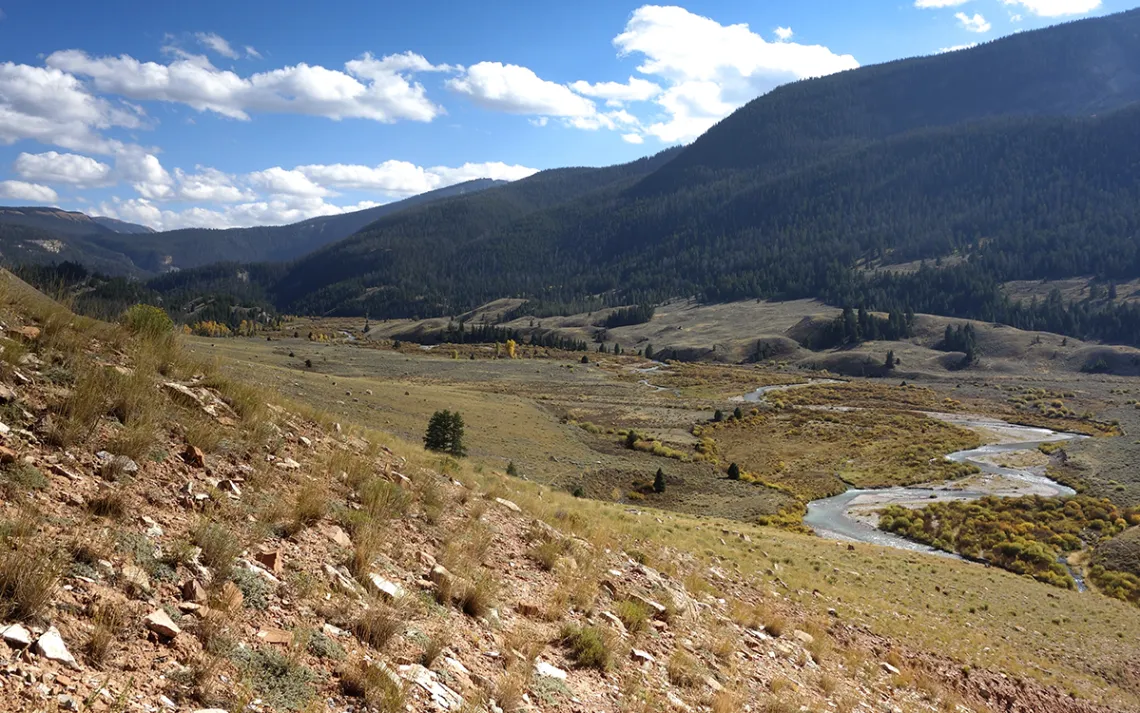
In this high desert valley ringed by mountains, the Teton Range wins the award for aesthetics. But for explorers and geology buffs, it’s tough to beat the Gros Ventres. One of the reasons the majority of the range is a designated wilderness area is because of its unique expressions of geology and geologic diversity. Crystal Peak isn’t the first mountain to slide in the area, and Crystal Lake isn’t the first landslide-created lake in the range. On June 23, 1925, 50,000,000 cubic yards of debris—enough to bury Washington, D.C., six inches deep—tore off the northern flank of Sleeping Indian. It created a mile-long, 200-some-foot-high natural dam across the Gros Ventre River. Lower Slide Lake, today a favorite SUP-ing spot for locals, formed upstream of the dam. (The drive to the Crystal Creek Trailhead takes you right past and through the Gros Ventre Slide, and there’s a developed campground at one end of Lower Slide Lake.)
The more recent Crystal Peak landslide destroyed a prime camping area. Jackson Ranger District trail supervisor Tim Farris remembers camping and playing Frisbee in the meadows beneath the peak’s north face. “All of a sudden this entire meadow we camped out in was gone,” he told me. “I took some geology classes in college, and this is like a textbook come to life. Over the last several years, I’ve seen this entire area change into this whole new place. How cool is that?” Farris didn’t even mind having to rebuild the Crystal Creek trail three times, until, finally, he and his crew rebuilt it high enough on a timbered hillside opposite Crystal Peak. “At this point, if the slide continues to come down, the trail will be OK. Most likely.”
Three weeks after first seeing the slide, I returned. My geology chops don’t extend beyond the ability to differentiate between granite and limestone. At the time, I wasn’t sure why this landslide so enthralled me; I just knew that it did. I passed up an invitation to hike the Teton Crest Trail, instead opting to explore baby Crystal Lake.
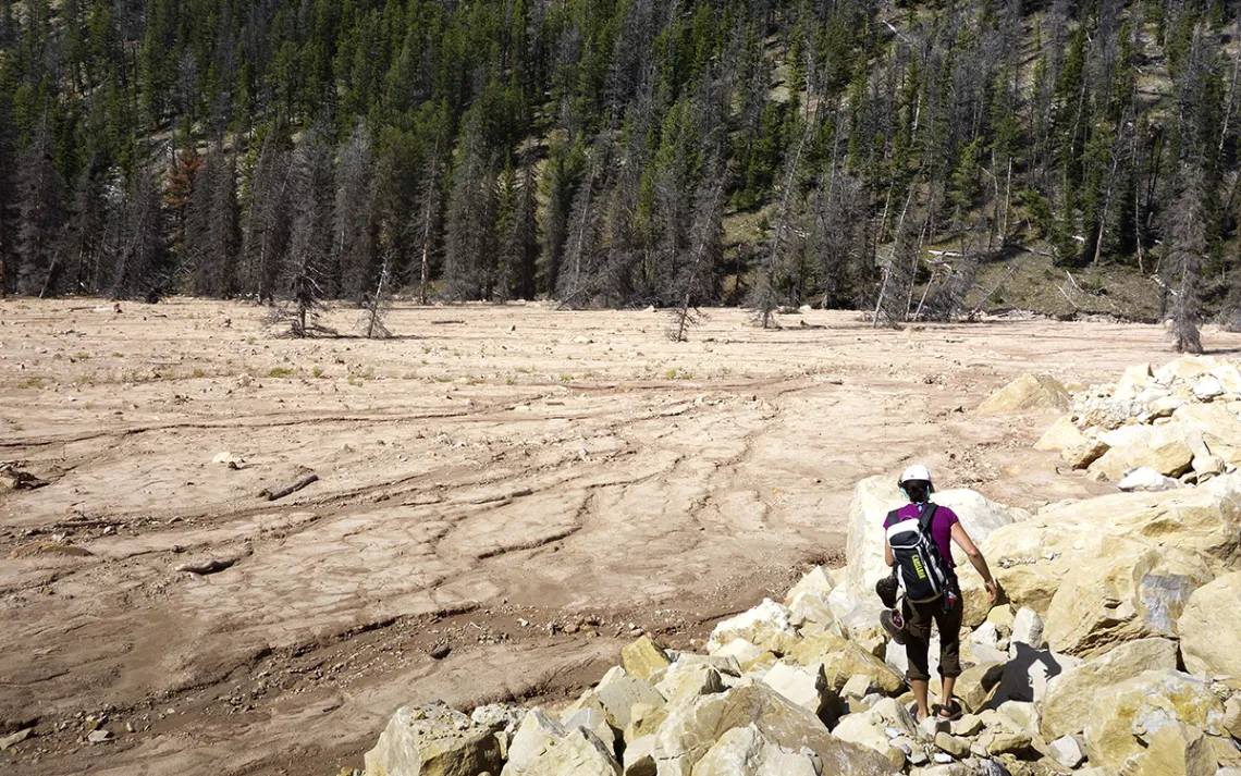
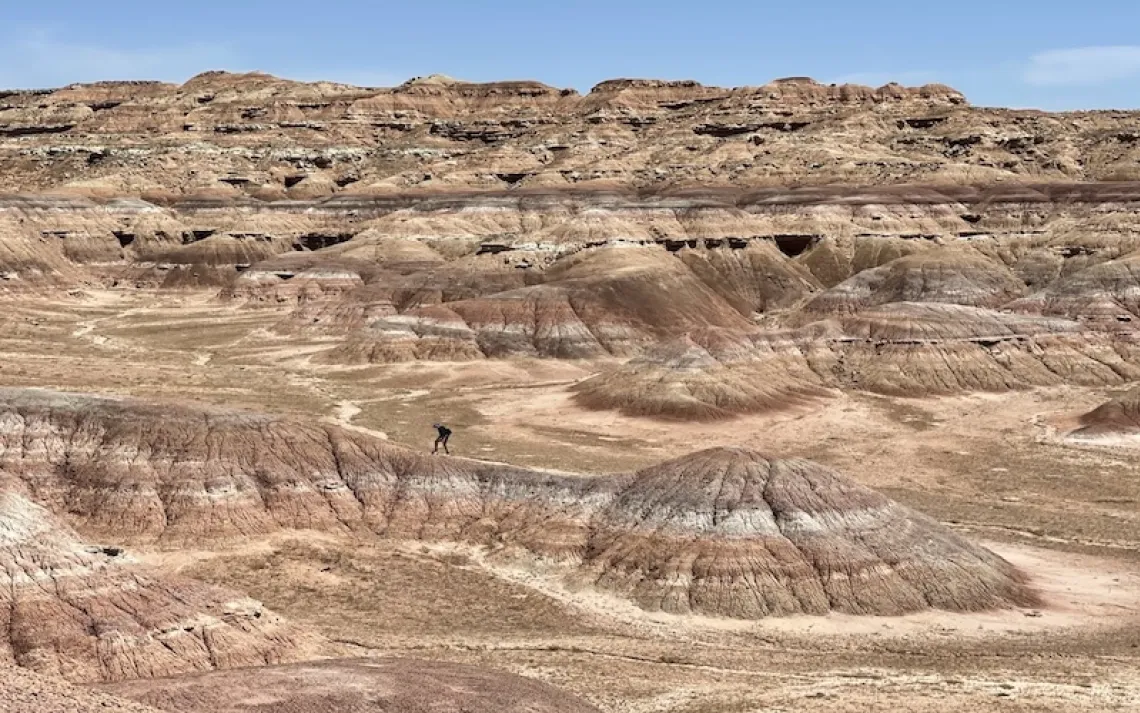
From the new trail Farris had recently built above the debris field, I looked down on a chaotic mess of brown-gray moonscape entirely denuded of life. There was the mess of boulders, trees, and debris, which gave way to petrified mud/silt flats. Above, Crystal Peak bore the raw scar of a deep gash of bare dirt dotted with giant boulders. Witnessing such complete destruction of the valley’s floor was depressing. I’d never seen a landscape so decimated by nature itself.
But then, past the mud flats lay an improbably turquoise lake. At the inlet to the lake, Crystal Creek was shallow and placid. It took only an easy hop to cross. I bushwhacked along the lake’s unformed south shore, between the trunks of still-living lodgepole pines, where spectacularly green webs of algae bloomed. Bordering water a shade of blue I hadn’t seen outside the Caribbean, it was the most interesting and beautiful chaotic mess I’d ever seen.
Every summer since first finding the slide and lake, I’ve returned to see how things have changed. I’m still waiting to see any sign of life—an anemic blade of grass, say, or any of the columbine or silky fusilier or lupine that formerly grew everywhere in this area—sprouting up through the hardened silt. Or to discover that even more of the mountain has slid. To date, I’ve found little plant life in this moonscape besides a couple of blades of grass, nor further destruction, but I have seen Crystal Lake grow. Last summer, its water was as still as it was blue, and its algae as green as when I first saw it. This summer, who knows what I’ll find?
FOLLOW IN THE WRITER'S FOOTSTEPS
Where: In the Gros Ventre Wilderness of the Bridger-Teton National Forest, Crystal Lake is six miles up the Crystal Creek Trail, which starts at the end of FS Rd. 30377.
Getting There: North of the community of Kelly, Wyoming, turn onto the Gros Ventre Rd., which is paved for a short time and then becomes dirt. (Normal passenger cars will do just fine until the very last mile or so.) Head east on the Gros Ventre Road, past the Gros Ventre Landslide National Geologic Area, Lower Slide Lake, and the Red Hills and Crystal Creek Campgrounds. About 10 miles down the Gros Ventre Rd., look (on the right) for signs for the Red Rock Ranch and Forest Service Rd. 30377. Turn right onto this road. Passenger cars can handle it until the turnoff for the Red Rock Ranch, after which it gets rocky and bumpy enough that if your car doesn’t have high clearance, you might want to walk. At the Red Rock Ranch, there is an intimidating sign that says “End of road. Red Rock Ranch not open to public.” It looks like this sign references all land past the sign, but it does not. FS 30377 does indeed continue on to the left. The trailhead is about one mile past this fork.
When to Visit: The road to the trailhead is open to cars from June 1 through October, conditions permitting, though early August to September are best because you must ford Crystal Creek at least three times to get to Crystal Lake and the Crystal Peak slide. In high water, these crossings can be treacherous. Also, during these months, bugs usually aren’t a problem and fall colors can be spectacular.
Survival Tip: The most difficult part of this hike is at the very beginning: Your first move from the parking lot is fording Crystal Creek. (There is no bridge across the creek, and it flows fast and strong here.) BTNF trail crew members recommend walking downstream a couple of hundred feet to cross. Look for a shallower spot with some rock bars. Expect a second, much mellower creek crossing that brings you back to the northeast side of Crystal Creek about 1.5 miles up the trail. There is a nonmaintained trail that goes across a steep, loose hillside several hundred feet above Crystal Creek and keeps you on the northeast side of the creek and allows you to avoid both creek crossings. Do not attempt this option if you have any issues with exposure or heights. If you slip on this trail, it could be catastrophic. If you’re comfortable in your hiking abilities and with heights, look for this trail at the east end of the parking lot. By going this route, you will bypass the first two-ish miles of the official trail.
Pro Tip: Bring trekking poles and creek shoes—Crocs are my favorite—for creek crossings.
Must-See: Once you’re into the open meadow beyond the first two creek crossings (or past the loose, nonmaintained trail option), you’ve got about two miles before the Crystal Peak landslide will come into view. This happens before the intersection of the Crystal Creek Trail with the Jagg Creek Trail. It’s worth going another two miles to get to the base of the slide and Crystal Lake.