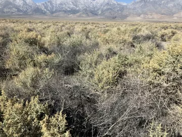
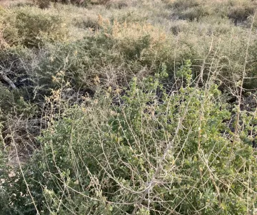
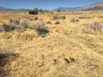
When you first visit an LADWP mitigation site, it can be hard to tell what to look for. Some problems are obvious: a field full of Russian thistle, for example. But what constitutes a healthy plant ecosystem here in Payahuunadü? The Long-Term Water Agreement (LTWA) divides local vegetation into five management types based on vegetation water needs, and marks parcels according to their management type as defined in 1984-1987 plant surveys. This article is not a comprehensive listing of the full diversity of plant species possible in these vegetation communities, but provide enough representation to determine if the area is maintaining healthy cover. (For plant images and other details for each species, click on the scientific name.)
Type A: Scrub communities with no groundwater needs
Plants are able to thrive based on annual rainfall and runoff alone. Expect to find this kind of ecosystem where groundwater levels are too low for plants to reach.

Plant varieties will vary based on soil alkalinity but may include:
(High-Alkali Vegetation)
| Burrobush | Ambrosia dumosa | Cheesebush | Hymenoclea salsola |
| Bud Sage | Artemisia spinicens | Wire Lettuce | Stephanomeria pauciflora |
| Shadscale | Atriplex confertifolia | Peach Thorn | Lycium cooperi |
| Allscale | Atriplex polycarpa | Indigo Bush | Psorothamnus fremontii |
| Winterfat | Krascheninnikovia lanata |
(Low-Alkali Vegetation)
| Big sagebrush | Artemisia tridentata | Ephedra | Ephedra nevadensis |
| Green rabbitbrush | Chrysothamnus viscidiflorus | Desert bitterbrush | Purshia glandulosa |
| California buckwheat | Eriogonum fasciculatum |
It is important to note that there is no local vegetation type with lower water needs than Type A. If these management zones transition, it will be to bare ground, increasing particulate pollution in the air, or to fields of Russian thistle.
Type B: Scrub communities requiring groundwater
These plant communities require more water annually than can be provided by rainwater, but their long roots allow them to thrive where the water table is too low to support other vegetation types, from 3-10 feet below the surface.

Primary plants in these management zones include:
| Nevada Saltbush | Atriplex torreyi | Rubber rabbitbrush | Chrysothamnus nauseosus |
| Greasewood | Sarcobatus vermiculatus | Inkweed | Suaeda torreyana |
Type C: Grasslands
These alkali meadows once dominated the valley but acreage diminished considerably in the 20th century. Remaining areas of Type C vegetation are a priority for conservation. While there can be some overlap with Type B vegetation, Type C management areas should not be allowed to transition to majority scrub. They require a water table no more than four feet below the surface for the majority of the year.

| Saltgrass | Distichlis spicata | Alkali Mallow | Malvella leprosa |
| Wild Licorice | Glycyrrhiza lepidota | Alkali Sacaton | Sporobolus airoides |
| Baltic Rush | Juncus balticus | Owens Valley Checkerbloom | Sidalcea covillei |
Owens Valley Checkerbloom is endemic to the valley and endangered by the loss of alkali meadows as our water table has fallen.
Type D: Marshlands and riparian foliage
Type D vegetation borders creeks and other waterways. The loss of springs has reduced the total Type D vegetation, but healthy examples are visible along the Owens River.
| Cluster Goldenweed | Pyrrocoma racemosa | Beardless Wild Rye | Elymus triticoides |
| Willow (various) | Salix | Saltgrass | Distichlis spicata |
| Woods Rose | Rosa woodsii | Baltic Rush | Juncus balticus |
| Fremont’s Cottonwood | Populus fremontii | Clustered Field Sedge | Carex praegracilis |
| Alkali Sacaton | Sporobolus airoides |
Cottonwood forests were once much more common on the valley floor and trees continue to be lost each year with few new saplings growing to replace them. Historically, dead cottonwood trees were cut down on LADWP lands but many of their stumps remain. Looking out over what appears to have always been scrubland and seeing long-dead cottonwood stumps is a stark reminder of how water has changed vegetation in Payahuunadü.
Type E: Areas that have historically received surface water irrigation
No set vegetation type characterizes these management areas and many areas support domestic crops and livestock. Management of these areas requires maintaining surface water application.
Invasives
There are a handful of plants that are bad news in any management type but that are unfortunately common.
| Russian Thistle | Salsola tragus | Cheatgrass | Bromus tectorum |
| Bassia | Bassia scoparia | Salt Cedar | Tamarix spp |
| Pepperweed | Lepidium latifolium |
Russian thistle (tumbleweed) and pepperweed are particularly adept at invading areas where native vegetation is stressed and pushing out those native plants that remain. Areas that appear healthy and green from a distance have often been all but entirely taken over by these two species, both of which are notoriously difficult to remove either manually or by use of pesticides. Anecdotal evidence suggests, however, that where sufficient water is available native species can reclaim territory previously occupied by these invasives.
The LTWA specifies that vegetation be maintained at the 1984-1987 baseline. Parcels are not to be allowed to transition to a lower letter type. Type D, for example, should not be deprived of water to the point of transitioning to Type C, B, or A. There is no requirement that LADWP restore vegetation to a previous state. Since the vegetation baseline was established after more than a decade of heavy, unregulated groundwater pumping, its standards already reflect a severely compromised state.
The exceptions to this rule are the vegetation-oriented mitigation projects. Through a series of negotiations, these areas were designated for special projects designed to either restore particularly damaged areas, or to create new vegetation areas to replace the habitat lost elsewhere – a new riparian area near the site of a dry spring, for example. LADWP has aimed in many cases to satisfy the minimum requirements with a minimum application of water. For instance, in areas where groundwater levels are too low to support the required vegetation type, LADWP applies sporadic surface water. In too many cases, this experiment in low-water mitigation has failed. Ground cover is sparse, species diversity is low, and the mitigation site becomes a fertile ground for invasives. This article series will visit mitigation sites and explore LADWP’s non-compliance in detail.
While these articles will remain focused on mitigation sites, it is worth noting that recent Inyo County data shows significant vegetation loss in 32 out of 148 non-mitigation parcels, over 21%, a clear violation of the LTWA. Current groundwater extraction levels are too high to maintain legal commitments to our local ecosystem or to fully restore designated mitigation sites.
References
Danskin, W.R. (1998). “Evaluation of the hydrologic system and selected water-management alternatives in the Owens, Valley, California.” Prepared in cooperation with Inyo County and the Los Angeles Department of Water and Power. Accessed September 18, 2022.
James, G. et al. (1990). “Green Book for the Long-Germ Groundwater Management Plan for The Owens Valley and Inyo County.” Inyo County and the City of Los Angeles. Accessed September 18, 2022.
Yamashita, I. (1999). “Revegetation Plan for Impacts Identified in the LADWP, Inyo County EIR for Groundwater Management.” Inyo County Water Department. Accessed September 18, 2022.