By Lynn Boulton
The scoping period recently ended for the 2022 BLM Solar Programmatic Environmental Impact Statement (PEIS) also known as the Western Solar Project. The project is a revision of the planning for large-scale solar on BLM lands completed in 2012. Ten years later, the technology has evolved significantly and solar development doesn't need to be only on flat land and in very sunny regions. This scoping process asked for feedback on adding five more states to the plan: Washington, Oregon, Idaho, Montana, and Wyoming and for adjustments to the 2012 plan that covered California, Nevada, Arizona, Colorado, Utah, and New Mexico. The Range of Light Group was involved in preparing comments submitted on behalf of the Sierra Club California and Sierra Club's Nevada Chapter. Most of southern Nevada was designated as a variance area and some areas in the Eastern Sierra as well. A key part of our comments asked the BLM to identify areas that should not be used for utility scale solar and to reduce the amount of variance areas. A variance area means the decision whether a particular area is appropriate for solar, would be deferred until there was a project proposal. We have serious concerns about the variance process and whether the BLM would turn down a project at that point. Here is the 2012 BLM solar energy map. There is no date yet when it will be updated to reflect input from the 2022 scoping process.
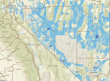
(blue is where solar could go, the variance areas)
Almost in parallel, California's Energy Commission was also planning where large-scale solar projects are likely to go or could go. The planning will help the state's Public Utilities Commission plan new transmission lines and substation or upgrades. This planning process included input from environmental groups as well as solar companies to figure out where solar could and would likely go and where it absolutely should not go. They have revised their map to reflect the input they received. We encourage you to take a look. In general, the majority of solar development will be in the Central Valley. The Eastern Sierra does not have areas large enough to attract solar development because most of our lands are protected. There are a few places that are open to solar in forested areas in Mono County. However, isn't likely that a solar company would propose clear cutting the forest to put in solar so we aren't concerned about that. However, there are a few places that are designated as available and two of them are included in the Inyo County Renewable Energy General Plan Amendment: Sandy Valley and the Chalfant Hills. The area to the west of the protected Volcanic Tablelands is open in both the California plan and the BLM plan, which is the area in the Eastern Sierra that is maybe the most vulnerable, but probably low on developer's list of desirable places.
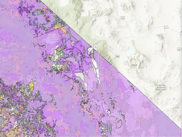
(white is where solar could go)
There is a recording of the CEC workshop worth watching that explains what the project is about and why. It is a great series of presentations. An interesting result of the CECs planning process was a map of where solar projects have been installed throughout the state. It starts at 1:57:13 of the presentation. Sadly, very little shows up in Inyo and Mono Counties.
We are preparing a presentation on both the updated California map and the 2012 BLM map that step through the two maps and show the areas marked as available for solar development in the Eastern Sierra. Hope you will join us for that. We'll let you know when, soon.