By Lynn Boulton
It has been 16.5 years since water came down the Owens River to the Owens Lake. Is it time to celebrate? Not quite. While it is great to have the river back, it isn't a healthy river system. This is a critical year in that monitoring activities related to the riverine system will stop unless adaptive changes are made that might need continued monitoring to see if they are working. Last year LADWP and Inyo County conducted various surveys and studies to assess the effectiveness of re-watering the lower part of the Owens River--what's working; what's not. Studies included bird surveys, a tree survey, and invasive weeds studies and a mapping of the types of vegetation along the 62 miles of river. The results of those studies are that the goals for the riverine system have not been met yet.
To mitigate the severe impacts to the Owens Valley from the heavy groundwater pumping in the 1970s and 80s by LADWP to fill the second barrel of the LA Aqueduct, the Lower Owens River Project (LORP) was developed among other mitigations. The Sierra Club, Owens Valley Committee, CDFW, and others sued LADWP over the lack of mitigation for all the damage done to the environment: lost springs, lost river, lost meadows, lost trees, dust, etc. The LORP was one of the mitigations created on top of the 1991 EIR mitigations to better compensate for these losses. This became known as the 1997 MOU. "The goal of the LORP is the establishment of a healthy, functioning Lower Owens River riverine-riparian ecosystem, and the establishment of healthy, functioning ecosystems in the other physical features of the LORP, for the benefit of biodiversity and Threatened and Endangered Species, while providing for the continuation of sustainable uses including recreation, livestock grazing, agriculture and other activities.”
There are four parts to the Lower Owens River Project (LORP): the riverine system, the Blackrock Waterfowl Management Area, the Delta Habitat Area, and off-river lakes and ponds (Billy Lake, Goose Lake, Twin Lakes). Adaptive management changes are in process for the Blackrock Waterfowl Management Area and the Delta Habitat Area. Yet, no changes have been made to the riverine system since the 1997 MOU Agreement was signed. The terms require a minimum of 40 cubic feet per second (cfs) of water flow through the lower 62 miles of the Owens River. To get 40 cfs at the outlet, up to 90 cfs might need to be released at the LA Aqueduct Intake (Goodale Rd.) where the river splits. Most of the water goes into the LA Aqueduct, but some water flows down the Owens River. The 40 cfs can be used for dust mitigation on the Owens Lake or be pumped back to the LA Aqueduct near Highway 395. On snowpack years of 50% of normal or better, a seasonal flow of 200 cfs is released for up to two weeks.
|
|
The goals for the riverine system have not been achieved yet. The river flattens out north of Lone Pine and the water spreads west creating a marshy area. Sediment is accumulating in that area and hampering the flow as well. Tules have grown in the river channel below the intake. A bigger flushing flow is needed but, any amount over 700 cfs will flood the roads crossing the river as it is doing now. This June and July, 650-800 cfs will be flowing down the river. This might be the flushing flow sufficient to clear a channel through the marsh area, but we won't know until next year. Tree recruitment along the river has not been good and the trees that were there have died. There is more variety of birds when there are trees and willow understory. To improve conditions and to meet the intended goals of the riverine system, changes need to be made. The MOU parties have ideas how to do that and have asked for a meeting since 2014 to discuss possible actions. LADWP doesn't believe there is a solution all parties will agree to and so, has not called a meeting. The Sierra Club is still hopeful the MOU parties will meet and that together we can improve the riverine system.
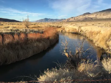
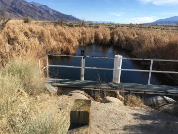
photos:
1 of the Owens River above the LA Aqueduct
1 of the river below it.