Amid Soaring Heat, a Grand Canyon Icon Was Incinerated
As the planet gets hotter, public lands are more vulnerable
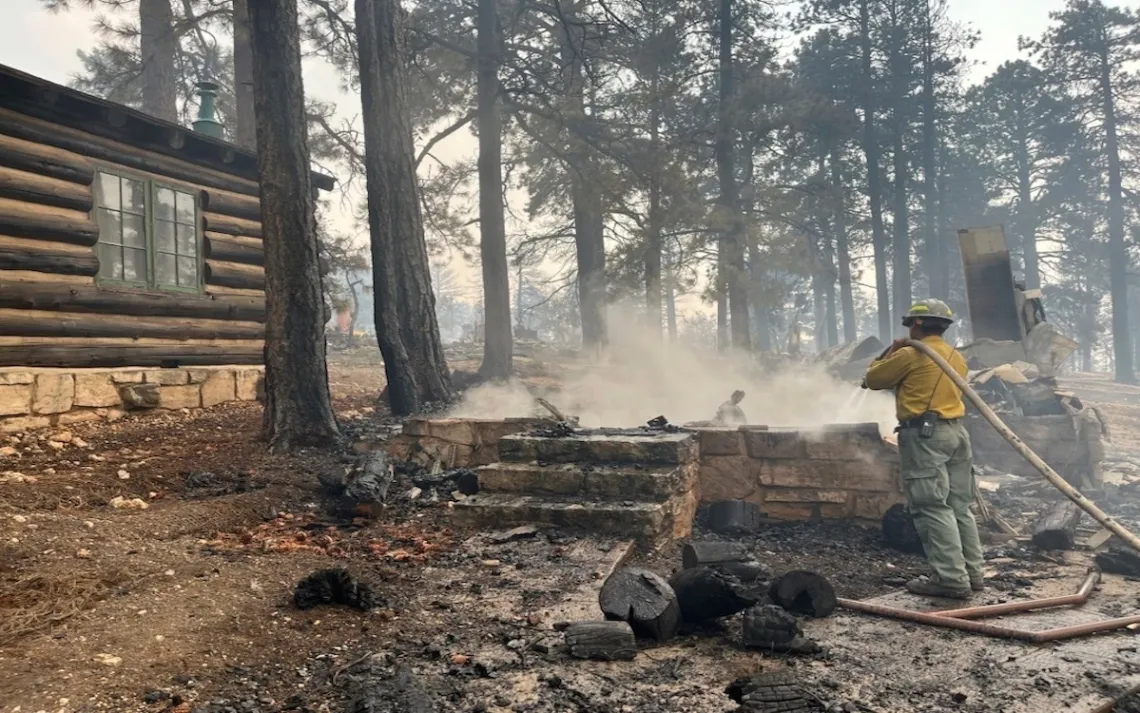
Charred remains of the North Rim's Grand Canyon Lodge on July 13. | Photo by National Park Service via AP
The Grand Canyon’s North Rim has long been a quieter counterpoint to the South Rim and its teeming tourist village, where there are stores, parking lots, hotels, shuttle buses, a campground, a train station, and housing for 1,600 seasonal residents plus more than 4 million visitors. Up on the North Rim, returning from a hot trek along Bright Angel Creek, from Phantom Ranch by the Colorado River—where summer temperatures now exceed 110°F for days in a row—and via Ribbon Falls, you could relax at the historic Grand Canyon Lodge. You could sip a cold drink with your feet propped up on the patio’s stone wall, taking in the barely audible hum of the abyss.
Now that refuge is gone.
On Sunday, July 13, lightning-caused flames that the National Park Service had let burn for nine days engulfed the lodge and adjacent log cabins, devouring a gas station and a water treatment plant along with it. Two smoke-choked trans-canyon trails with Phantom Ranch at the bottom as their hub have been closed. So have all inner-corridor trails, the network of hikers’ highways inside the gorge. A second wind-driven fire had spread to 78 square miles by Monday. A chlorine gas leak and poor visibility at night hampered firefighting efforts.
“It’s a disheartening loss,” says Stephen J. Pyne, author of The Pyrocene: How We Created an Age of Fire, and What Happens Next.
Snowmelt is typically the determining factor for fire conditions in the area, and both rims are prone to receiving late-winter blizzards. However, “What matters is the dryness and length of the spring, not the total snowpack,” says Pyne. “That early-season dryness is what drives the big fires, which typically occur prior to or at the onset of the monsoon season.”
In 1932, the Spanish-style lodge sited on the North Rim, constructed with native limestone incorporating massive ponderosa beams and an observation tower, burned down due to a kitchen fire. Redesigned, it opened again in 1937 as the second Grand Canyon Lodge. The architect, Gilbert Stanley Underwood—responsible for much national park architecture throughout the United States—steepened the roof and strengthened the masonry to account for the Kaibab Plateau’s heavy snowfalls. Much less wood was used and more steel beams and trusses instead, reducing the fire risk. The site was declared a National Historic Landmark in 1987.
Photo courtesy of the Grand Canyon Conservancy/NPS
The North Rim, 1,000 feet higher on average than the South Rim, is a magnet for lightning strikes. Before the age of satellites and aerial photography, sharp-eyed seasonal rangers with the Forest and Park Services diligently manned lookouts at Jacob Lake (the Route 89A junction between Page and Kanab that leads to the park) and near the park’s northern entrance station, 14 miles from the rim.
After decades of rigorous fire suppression, the Park Service adopted a more lenient management policy. This sprang from the awareness that wildfire always had been an important, cyclical factor in the Kaibab National Forest’s makeup. Frequent, low-intensity surface fires yield fertile ash, preparing a seedbed for ponderosa saplings. Burns also weed out underbrush and small trees, opening the canopy for grasses on which mule deer and other wildlife feed. For centuries, Native Americans had primed such forage by sparking fires on purpose. On average, without management, ponderosa-pine plant communities ignite locally every five to 25 years.
Pyne, a professor emeritus for environmental history with the Arizona State University, says that beyond dry springs that establish the capacity for big fires, “burned area correlates much better with changes in policy, staffing, practices, etc.” His long-term data from various kinds of Grand Canyon conflagrations show that the total acreage consumed between 1960 and 2005 has quintupled. Overall, big burns grew from “managed fires that went wild.”
Pyne knows the rim well, having spent 15 years on a fire crew there, a dozen of those as a crew boss. While he cautions that single events cannot be easily linked to global warming, a larger pattern with these events can be discerned. With the lasting megadrought and the Park Service’s former zero-fire approach, shrubbery over the years accumulated as the perfect tinder and fuel. When fires burn nowadays, they tend to burn hotter, easier, and more explosively. In fact, public and private land managers no longer like to speak of “controlled burns”—fires set to piles of timber and brush thinned from the woods—but of “prescribed burns.” That latter term, coined in 1942, in Pyne’s words describes “a compromise practice between mindless suppression and unrestricted folk burning.”
Pyne has studied megafires closely, such as a 2006 blaze that “blew up and scoured 58,000 acres as winds from a collapsing pyrocumulus [cloud] drove flames and embers through dense forest.” That’s 44,000 scorched football fields. Monster fires produce their own localized weather phenomena. The present North Rim fire is aptly named Dragon Bravo.
The North Rim and its access, Arizona State Route 67, normally open for overnight use until October 15, and for day use until November 30, have been officially closed for the rest of the season. With the recent budget cuts to the Park Service mandated by the Trump administration, this place of comfort and contemplation, of rest, recuperation, and refreshment, will be deeply impacted.
The director of the Sierra Club’s Grand Canyon Chapter, Sandy Bahr, says that the tragedy of the Grand Canyon Lodge should be a wake-up call. “After the smoke settles, we will have more answers,” she says. “Right now, we encourage people to focus on supporting firefighters and those displaced and as always to support our national parks, including Grand Canyon.”