In 1964, the Wilderness Act established the National Wilderness Preservation System. The purpose of the Act was to "secure for the American people of present and future generations the benefits of an enduring resource of wilderness."
In 1990, the Illinois Wilderenss Act designated 7 Wilderness Areas located in the Shawnee National Forest. Together they represent over 27,000 acres that are protected in perpetuity from development, logging, mining, and motorized vehicles and equipment.
The Shawnee National Forest spans 287,000 acres (450 square miles) in southernmost Illinois from the Ohio River to the Mississippi River. Located at the convergence of five geological areas, the Shawnee contains abundant biological diversity found within the rugged terrain of the Ozark Hills, to the massive sandstone bluffs of the Shawnee Hills, to the gently rolling Cretaceous Hills.
The 7 Wilderness Areas are located across the breadth of the Shawnee. They are Clear Springs, Bald Knob, Panther Den, Burden Falls, Bay Creek, Lusk Creek, and Garden of the Gods.
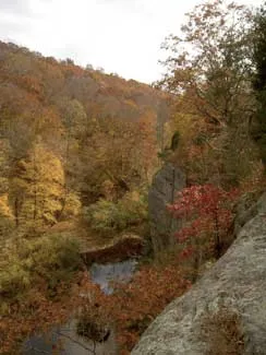
Clear Springs-Bald Knob Wilderness Areas
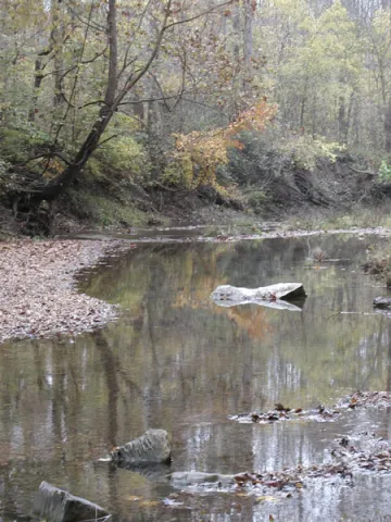
Although Clear Springs Wilderness and Bald Knob Wilderness areas are considered two separate areas, geographically they are one area. Separated only by Hutchins Creek, they are located in the Illinois Ozark natural division. Immediately to the south and west lies Camp Hutchins Proposed Wilderness Area (2967 acres); together the three areas comprise over 13,000 wilderness acres. Hutchins Creek (eligible for designation as a Wild & Scenic River) has formed a wide, flat valley bordered by steep forested slopes, rocky bluffs, and V-shaped creek drainages. This area is relatively undisturbed by humans, with a couple of old farmsteads and cemeteries the only evidence of past human usage of the land. The mixed mesophytic forest and the clean, spring fed creeks, typical of the Ozarks, provides habitat for wildlife including neo-tropical songbirds, wild turkey, deer, bobcat, and many smaller mammals.
Getting There
Godwin Trail--east trail head
From Jonesboro, IL take State Rte. 146 west to State Rte.127; turn north to Alto Pass, IL; take the Bald Knob Road west for about 2.7 miles; the trail head is on the right. There is parking for two or three vehicles.
Godwin Trail--west trail head
From Jonesboro, IL take State Rte. 146 west to State Rte. 3 and turn north; turn east on Big Muddy Levee Road to a T-intersection at the base of the Pine Hills bluff. Left at the T-intersection leads to Pine Hills Scenic Drive, Forest Road 236; turn right and follow 236 as it ascends over 250 feet above the Mississippi bottomlands to the bluff top above. Less than a mile south of the Inspiration Point parking area you will come to the Godwin trail head. It is very well marked and there is space for a few vehicles.
Hutchins Creek--Clear Creek Trail trail head
This trail lies within the interior of the two wilderness areas and can only be accessed from the Godwin Trail.
Ranbarger Hollow Trail
This trail intersects the Godwin Trail not far from the east trail head.
Bald Knob Trail
Continue driving to the end of Bald Knob Road. On the left is an enormous cross where people visit for the tremendous view of the Shawnee. On the right, due west of the cross, is the Bald Knob trail head.

Exploring
Caution: You may encounter many user-made trails that are not described here -- use maps and use caution -- it's very easy to get disoriented in the rugged terrain of the Illinois Ozarks.
Running east/west is a 6-mile segment of the River-to-River Trail called the Godwin Trail. The trail is marked with a blue i symbol for the River-to-River Trail. The west trail head begins in Bald Knob Wilderness at approximately 700 feet elevation in mature forest dominated by oak-hickory. It gradually descends in a southeasterly direction, following a long narrow ridge, to Hutchins Creek at 300 feet elevation. After crossing the creek you are now in Clear Springs Wilderness; the trail climbs out of the valley in a westerly direction until it reaches the east trail head at approximately 800 feet elevation. You may either do a car shuttle, or retrace your steps.
Intersecting the Godwin Trail where it crosses Hutchins Creek is the Hutchins Creek--Clear Creek Trail. It follows the creek upstream to the north for a of couple miles and then heads west another couple miles before intersecting the Godwin Trail.
The Ranbarger Hollow Trail intersects the Godwin Trail not far from the east trail head. It follows a ridge top before a gentle descent into the hollow -- a wide creek valley.
Bald Knob Trail is about a 3 1/2 mile loop within Bald Knob Wilderness.
Use the Cobden and Wolf Lake topographic maps for Bald Knob-Clear Springs Wilderness Areas.
Panther Den Wilderness Area
At just over 900 acres, the smallest Wilderness in Illinois, Panther Den shares its northern boundary with Crab Orchard Wilderness (part of Crab Orchard National Wildlife Refuge managed by the U.S. Fish and Wildlife Service). Together they form over 5000 acres of protected wilderness. Three fingers of Devil's Kitchen Lake extend into the northern section of this area, offering opportunities for viewing wildlife, canoeing, photography and fishing. Sandstone bluffs and multilayered rock formations are found throughout Panther Den. Sheltered overhangs beneath the bluffs provide habitat for the endangered French's shooting star. Muskrats, deer, and beavers are common sights. Mink and bobcats (endangered in Illinois) have been seen here, too.
Getting There
Take Exit 40 on I-57 (same exit for Ferne Clyffe State Park). Using the Lick Creek topographic quad map follow County Road 23/61 west to County Road 276, turn north (right). The road makes a 90-degree turn to the west (left) and becomes County Road 45. After about 2.5 miles you will come to a T-intersection; turn north (right); after another mile the road makes a 90 degree bend to the west (left); at this point a gravel road, Forest Road 725, takes off to the north (right); a small parking area is on the right; park here and walk the road to the Wilderness; about 0.25 miles up the road you will encounter a gate which may or may not be closed; walk around it and proceed towards the Wilderness; (if you find the gate open you may be tempted to drive on down the road – this not advised because the gate belongs to a private individual who lives along the road and he could easily lock the gate with you inside).

Exploring
Panther Den Loop trail begins at the end of the road -- look for signs. The trail drops down, crosses creeks and winds its way through a maze of giant boulders, and offers views of the lake before ascending to the ridge top and beginning of the trail. The Loop trail intersects the River-to-River Trail at a couple points, so be careful not to get side-tracked. Use the Lick Creek topograhic quadrangle map for Panther Den Wilderness.
Bay Creek Wilderness
Bay Creek Wilderness is named for the upper reaches of Bay Creek, a major watercourse that runs through the Shawnee before it eventually joins the Ohio River. Woodland species including oak, cedar and ash, and flowering trees such as dogwood, redbud, wild cherry and plum occur in the Wilderness. Pine plantations in the Wilderness are a reminder that this area was once comprised of farmsteads that were reforested in the 1930s when the land became part of the National Forest System. Bay Creek contains bluffs colored by bands of iron oxide, unusual sandstone formations and shelter caves. Bay Creek is adjacent to Burden Falls Wilderness and very close to Bell Smith Springs National Natural Landmark. Hiking and camping are unrestricted.
Getting There
From Harrisburg, IL, take State Rte. 145 south approximately 12 miles; turn west on graveled Forest Service Road 402 at Delwood for about three miles until you reach a small parking lot for Burden Falls Wilderness -- park here and enter Bay Creek Wilderness directly across the road.
Exploring
There are several old trails and user-made trails within the wilderness, but there are no established Forest System trails. Use the Eddyville and Stonefort topographic quadrangle maps for Bay Creek.
Burden Falls Wilderness
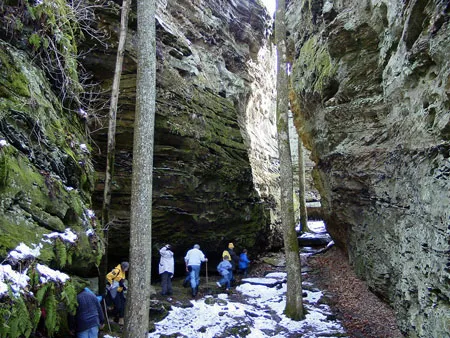
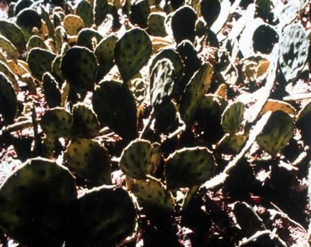
An intermittent,seasonal stream spills over Burden Falls in a picturesque series of waterfalls with a total drop of about 100 feet and the greatest single drop a distance of 20 or so feet. The Wilderness shares a boundary with Bay Creek Wilderness to the south, and both exemplify the scenic characteristics of the Shawnee Hills: sandstone ledges, bluffs and cliffs on which grow xeric communities of red cedar, farkleberry and blackjack oak. At the bottom of the bluffs, you'll find greater soil depth supporting post oak and, as you move away from the cliffs, even deeper soil where white oak grow. The area supports several unique species of plant life including Carolina buckthorn, seldom seen this far north, rock chestnut, prickly pear, royal fern, glade fern and the cardinal flower. In the deciduous forest, you may see white-tailed deer, wild turkeys, gray squirrels and numerous species of other small mammals. The barred owl lives here with pileated woodpeckers and eastern bluebirds.
Getting There
From Harrisburg, IL, take State Rte. 145 south approximately 12 miles; turn west on graveled Forest Service Road 402 at Delwood for about three miles to reach a small parking lot at the Burden Falls trail head.
Exploring
There is a 3.5 mile loop trail that begins at the top of the waterfall. Hiking and camping in the area are allowed. Bird watching and photography (especially when the falls are running) serve as draws for human visitors. Hunting and fishing are allowed. Use the Eddyville and Stonefort topographic quadrangle maps for Burden Falls.

Lusk Creek Wilderness
Lusk Creek Wilderness is named for the beautiful, clear blue creek that runs through it year-round and is known for numerous hairpin turns carved through sheer rock walls rising at points 100 feet above the creek. Intersected by many beautiful tributary creeks, Lusk Creek ranks as one of the state's highest quality streams and is eligible for designation as a Wild and Scenic River. Because of its diverse topography, Lusk Creek Wilderness contains numerous distinct biological communities and is home to several threatened and endangered plant and animal species. Lusk Creek Illinois State Nature Preserve, also known as Indian Kitchen, is located within the wilderness boundary, and well worth a visit.
Getting There
Lusk Creek Wilderness Area lies east of the town of Eddyville, Illinois, which is located on Hwy. 145 about 20 miles south of Harrisburg. Most public access points into the Wilderness are off roads near Eddyville. There are many miles of trails, and lots of trailheads. The Shawnee National Forest headquarters in Harrisburg, Illinois has excellent trail maps available--it's well worth the effort to get one of the maps before attempting to explore Lusk Creek.
Exploring
There are too many trails and trailheads to describe here. A detailed hiker/equestrian trail map covering the Eddyville/Herod area is available through the Friends of the Shawnee organization. A digital copy of the Lusk Creek area trail map is provided for viewing purposes only. The Eddyville/Herod Trail Map is available to purchase at the Harrisburg and Vienna Forest offices. To order the map through the mail visit the Friends of the Shawnee website.
Garden of the Gods
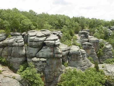
The Garden of the Gods Wilderness Area contains rock formations, canyons, bluffs and ridges carved by millions of years of wind and water. Breathtaking views of the rolling forest below can be admired from the massive sandstone formations along the ridge tops. All seasons have their special charm at Garden of the Gods, but the intense mosaic of colors in autumn is especially appealing. Below the bluffs, the hiking is easy and quiet through the hardwood trees, intermittent creeks, and moss-covered sandstone outcrops.
Getting There
From Harrisburg, IL take U.S. 45 south to State Rte. 145. Follow this road about 5 miles to Mitchellsville, IL and pick up State Rte. 34 through Herod to Karbers Ridge blacktop; turn left (east) to County Road 10; turn left (north) two miles to the entrance road.
Exploring
Several trails run through the area including a several mile stretch of the River-to-River trail. All visits should begin with the 1/4-mile interpretive, Observation Trail, for an overview of the natural history and fascinating geology of the area. Backcountry hiking and camping are allowed. Camping is also available at the Pharaoh Campground (located within the Recreation Area boundary). Its 12 campsites, drinking water, and pit toilets for $5/night make it a popular place to camp for day hikes into the area, or as a starting point for backpacking along the River-to-River Trail. The Recreation Area even offers a backpackers parking lot with a spur trail leading to the River-to-River Trail.
Use the Herod and Eddyville topographic quadrangle maps for Garden of the Gods Wilderness. Basic trail maps should be availble at a trail head kiosk off the main parking lot. A detailed hiker/equestrian trail map covering the Herod/Garden of the Gods area is available through the Friends of the Shawnee organization. A digital copy of the Herod/Garden of the Gods area trail map is provided for viewing purposes only. The Eddyville/Herod Trail Map is available to purchase at the Harrisburg and Vienna Forest offices. To order the map through the mail visit the Friends of the Shawnee website.
More information about Garden of the Gods Wilderness Area can be obtained from the Shawnee National Forest headquarters in Harrisburg, IL.