The Challenge of Reducing Flood Risks
The storm on June 12 this year showered over six inches of rain on San Antonio in just a few hours, resulting in 13 flood-related deaths. According to NOAA, Texas is one of the top states for flood risks. In particular, San Antonio is part of the nationally-recognized “flash flood alley” which is one to three counties wide from Cooke and Grayson counties at the north Texas border through Dallas-Fort Worth, Waco, Austin, and San Antonio to Medina County in the I-35 corridor. The steep terrain, shallow soils, and narrow channels of the Balcones Escarpment cause heavy rainfall to turn into rapidly flowing water and flooding. Of course, the increasing impervious acreage of roads, parking lots, and rooftops in this rapidly growing area contributes to the flooding.
The 1921 flood was the deadliest in the city’s history, taking the lives of more than 80 people, the vast majority of whom lived on the city’s West Side. This led to the construction of the Olmos Dam. The San Antonio Channel Improvements Project was authorized by Congress in 1954 and led to multiple projects including construction of the San Pedro Creek and San Antonio River flood tunnels. Fortunately, flooding on the West Side is now getting increased attention.
It took Hurricane Harvey to stimulate the Texas Legislature to pass Senate Bill 8 in 2019 that created Texas’ first statewide flood planning program. Current thinking emphasizes nature-based solutions to flood mitigation, such as pervious pavements, retention basins, bioswales, floodplains, and tree canopies, i.e., “green” infrastructure instead of “gray” (concrete) infrastructure.
Statewide flood planning requires vertical topographic digital data (such as LiDAR and elevation models), and it is a challenge ensuring accuracy, consistency, and coverage across a state with vast and varied terrain. The terrain continually changes from development, erosion, or land subsidence, and even small vertical inaccuracies (on the order of six inches or less) in digital elevation data can result in significant differences in delineated floodplain boundaries.
A challenge to flood planning is the fact that the climate is changing. Flood planners need to know future rainfall intensity, duration, and frequency to understand and predict flood events. Until 2022, state and local agencies had to try to make such forecasts, but now NOAA is producing precipitation frequency estimates for the entire United States, including future temporal trends through the year 2100.
So, there is a lot happening to reduce the risk of flooding in Texas and San Antonio, but it is important to support efforts to conserve critical natural landscapes and to constrain, and actually reduce, the amount of impervious acreage.
by Bill Barker, Alamo Group executive committee member
Ocelots in Texas: Conservation Challenges and Opportunities
Our July general meeting features Sharon Wilcox, PhD (Senior Texas Representative, Defenders of Wildlife).
Tuesday, July 15th
6:00 pm
Meeting schedule
| Informal get-to-know-you | 6:00 pm to 6:15 pm |
| Announcements | 6:15 pm to 6:30 pm |
| Featured program | 6:30 pm to 8:00 pm |
Venue
This is an in-person only meeting at:
William R. Sinkin Eco Centro, 1802 North Main Avenue
Map
Program topic
“We are on the verge of a 6th Mass Extinction, with species being lost at up to 1,000 times faster than normal because of human activities.“ - Defenders of Wildlife.
The traditionally high biological diversity of the Southwest Borderlands region is threatened by the usual forces of urbanization, agriculture, oil and gas drilling, and water diversion. Now it must also contend with climate change and the border wall. Iconic predators of the Borderlands, such as the Mexican gray wolf, jaguar and ocelot, are barely hanging on.
A medium-sized wildcat, ocelots have a distinct “chain rosette” spotted coat, a long ringed tail, and slightly rounded ears. Once ranging throughout the Southwest, today the only breeding population of ocelots in the U.S. is in Texas, where fewer than 60 ocelots remain in two small populations near the Mexican border. Occasionally, dispersing male ocelots from Mexico also migrate into southern Arizona.
The biggest threat to the ocelot’s survival is the loss of habitat caused by the expansion of agricultural lands, urbanization, and roads. Ensuring their future requires that habitat lands with suitable vegetation are enlarged and improved, and that unintentional threats from nearby communities, like the use of rodenticide and the dangers of vehicular traffic, are addressed.
Come and learn about this iconic Texas cat, and current efforts in ocelot conservation. Hear how better ways are being found to engage the energy industry, landowners and federal and state agencies for greater cooperation in species protection throughout the region, to ensure a future for wild west Texas.
About our speaker
Dr. Shari Wilcox serves as Senior Texas Representative for the non-profit organization Defenders of Wildlife, where her work focuses on conservation and recovery of imperiled and endangered wildlife in Texas, including the ocelot. She also serves as a member of Defenders' Southwest jaguar conservation team.
Before joining Defenders in Texas, Shari served as the Associate Director for the Center for Culture, History, and Environment in the Nelson Institute for Environmental Studies at the University of Wisconsin-Madison. In recent years, she has also worked for the Texas office of Ocean Conservancy, and she has served as a Lecturer in Geography at the University of Texas - Austin and the University of Texas - San Antonio.
Shari earned her Ph.D. in Geography from the University of Texas at Austin. She is the co-editor of the book “Historical Animal Geographies”, and has authored a number of scholarly articles and book chapters examining contemporary and historical interactions of humans and wild cats in the U.S. - Mexico borderlands. She is currently finishing her book, “Jaguars of Empire” under contract with the University of North Carolina Press.
The Alamo Group of the Sierra Club holds its general meetings the 3rd Tuesday of most months. They're always free and open to the public.
This Year's Legislature Not So Bad
Although we are facing at least one special legislative session, the regular session of the 89th Texas Legislature is officially over, and GEAA is glad to say we emerged from the session pleasantly surprised! A fair number of small but mighty legislative fixes to our water challenges, along with major water funding bills, made it all the way through the legislative process, while some bigger, highly detrimental bills and amendments failed to advance in the last stages of the session.
We’re thankful to all who joined in our efforts to advocate for rational, responsible legislation and against harmful bills this session. We couldn’t have done it without you!
I want to focus on the bills that GEAA supported that will become law. Find out about all our efforts this session, including a more detailed recap of the session and a finalized bill tracker, here: https://aquiferalliance.org/library/legislation/.
Groundwater conservation districts were granted enhanced ability to manage groundwater withdrawals, deal with permit violations, and respond to groundwater development. They also now face greater transparency and accountability in how they manage their groundwater supplies.
Homeowners’ Associations are no longer able to fine homeowners whose lawns turn brown during drought restrictions; large cities are required to undergo water loss reporting, auditing, and mitigation; governmental entities can adopt certain updated water conservation design standards; private and investor-owned utilities can enforce their drought contingency plans; and flood mitigation projects that also create an additional water supply can qualify for flood infrastructure funds.
Local governments can more easily engage in water planning and research; certain orphan wells will be required to be plugged by oil and gas companies; a shortfall in funding for the environmental permitting and support unit of the Railroad Commission will be addressed; and Texas Water Development Board will be directed to conduct and publish a study of the technical and economic feasibility of the use of recycled municipal wastewater by quarries currently using Edwards and Trinity aquifer wells.
With many thanks to the tireless work of Sierra Club members, and with special thanks to Richard Alles for his expertise, the bills targeting ashe juniper bills – home to the endangered Golden-Cheeked Warblers – failed in the home stretch.
And finally, the two major water infrastructure funding bills for which GEAA and many other water and environmental groups in Texas were strongly advocating passed. Senate Bill 7 has been signed by the Governor; it expands how water supply and water infrastructure funding will be administered. Water and wastewater reuse projects may now be funded under the New Water Supply for Texas Fund and wastewater infrastructure projects can be funded under the Texas Water Fund.
House Joint Resolution 7 dedicates $1 billion annually for the next 20 years to fund water supply and water infrastructure investments. 50% of the funds will be allocated to the New Water Supply for Texas Fund and the State Water Implementation Fund for Texas. The other 50% will be available to the Texas Water Development Board to fund existing, effective, and often oversubscribed programs. Voters will need to head to the polls in November to ensure that this constitutional amendment passes and that Texas water infrastructure is more appropriately funded.
by Rachel Hanes, Policy Manager, Greater Edwards Aquifer Alliance
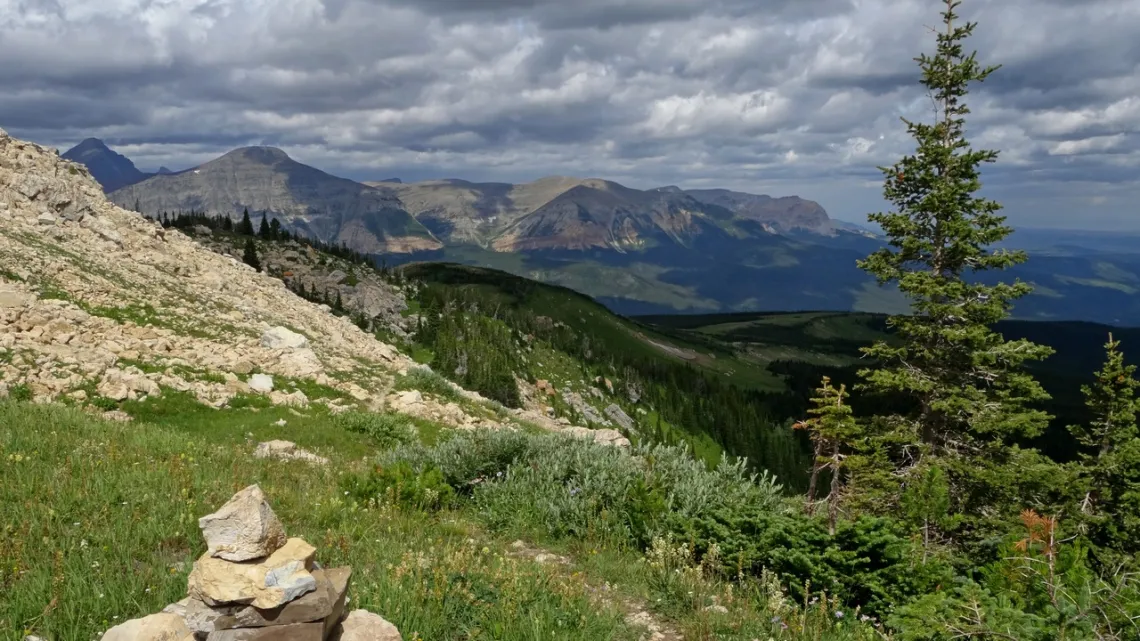
Glacier National Park, Northern Montana: a Tiny Glimpse #2
Further to article #1 in the June 2025 issue of this newsletter which included basic info about the park. Again, here's the NPS website and from there a high resolution PDF map, and the excellent website HikingInGlacier.com.
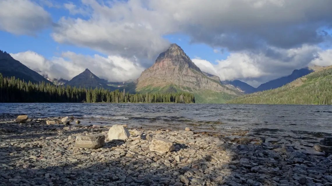
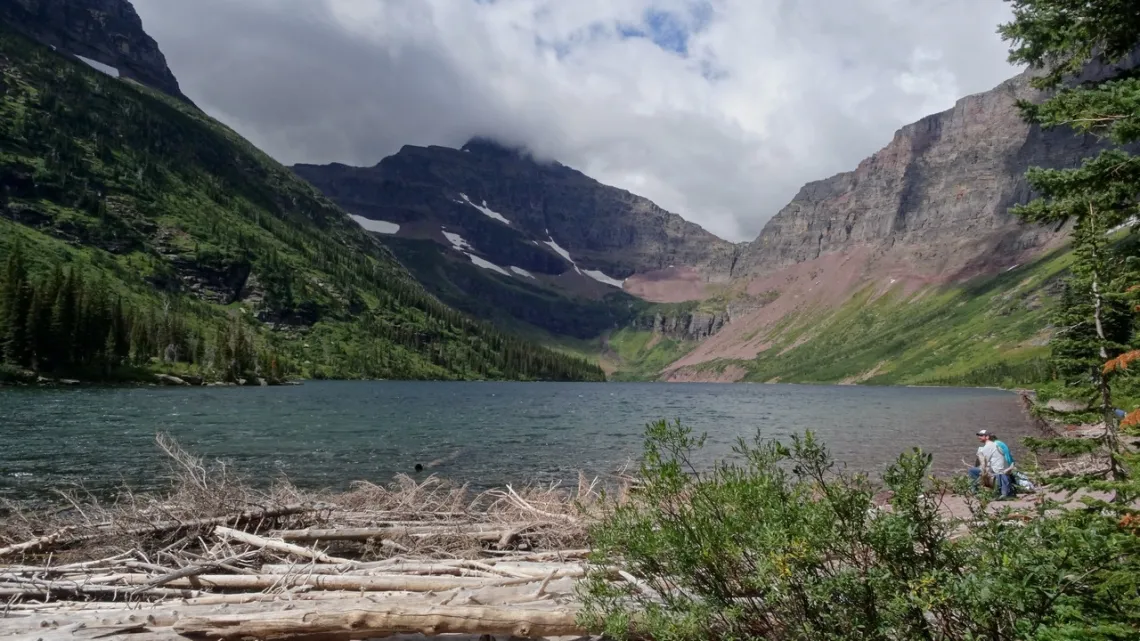
From the Two Medicine area
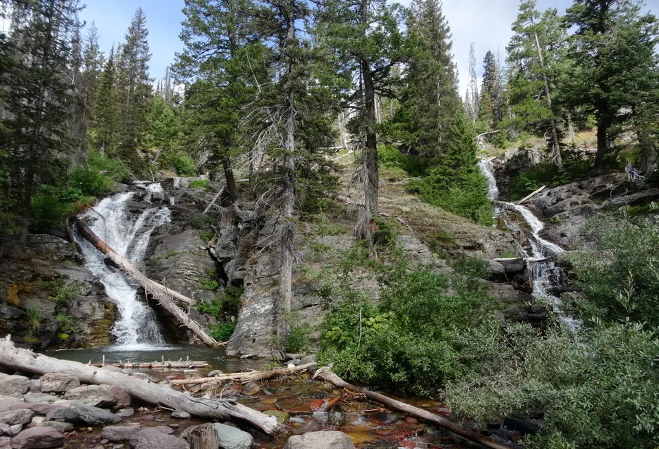
This is in the southeast corner of the park. Here is the Two Medicine area page with area map. From the Two Medicine campground there are popular trails around Two Medicine Lake and then Upper Two Medicine lake not far southwest, next two pictures. From the trail to Upper Two Medicine we can detour a bit west to Twin Falls, third picture.
Also on the trail past Twin Falls can hike past No Name Lake and up to Cut Bank Pass on the Continental Divide. From the south side of the loop trail around Two Medicine Lake we can continue southwest to Cobalt Lake and on to the divide. From the latter spot we go can southeast on the divide to Two Medicine Pass. If we can backpack there are campgrounds en-route to the divide and options for doing loops instead of simply out and backs.
Triple Divide Peak
The only place on Earth where waters divide to three oceans, originally covered in October 2015 (PDF). Looking at the map of continental divides in the Wikipedia article we can see this is at the junction of the Great Divide (aka Continental Divide) and Laurentian Divide. From the peak water drains west to the Pacific (via Columbia River), northeast to the Arctic (Hudson Bay), and southeast to the Atlantic (via Missouri River).
Surely we would like to get at least to Triple Divide Pass, just east on the Laurentian Divide, if possible! But that is 14.6 miles round trip, climbing 2400'. Looking at the big map can see access is from Cut Bank campground, halfway between the St. Mary and Two Medicine entrances, and then hiking west-southwest to the pass. There is a good page at HikingInGlacier.com by people who got to Triple Divide Pass which is 7350'; Triple Divide Peak is 8020'.
In July 2015 I was trying to get to the pass but the trail was closed about halfway along due to a major wildfire to the northeast. In the October 2015 article I incorrectly explained about the picture below; looking again at the picture coordinates and pictures found on-line am thinking the peak is the low one center in the picture.
Gable Pass, in the northeast corner of the park
From the Saint Mary entrance we can drive north on US 89 and then northwest on Montana 17 to the border crossing. The big map says this is Chief Mountain International Highway. I saw a sign there with parking that said it was an alternative northern terminus of the CDT. On the big map a short way back on the highway is the trailhead for a trail along Belly River, which I presume is that alternative northernmost CDT section.
A bit further down is the trailhead for Gable Pass, next picture. Gable Pass is about 10 miles round trip from the highway. Doing maybe an additional 4 miles we can make a loop of this, from just below the pass cutting southwest on a trail to the one along Belly River and then back to the border crossing. Wish had done that but was rather tired at the pass. Crossing the border we are in Waterton Park. Bunch of hikes and boat tours to do there.
A few last bits
East on US 2 from the west park entrance with headquarters, just west of the Apgar visitor center, we pass the first of three railroad depots of the historic Great Northern Railway adjacent to the park, visible on the big map. On the south side of the park, just south of US 2 are a couple nice US Forest Service campgrounds, Devil's Creek and Summit. The latter is on the Great Divide. A few miles further east we see a trail going up to Firebrand Pass on the divide. HikingInGlacier.com has a page about doing Firebrand with nice pictures. Round trip 10.2 miles, gain 1950'.
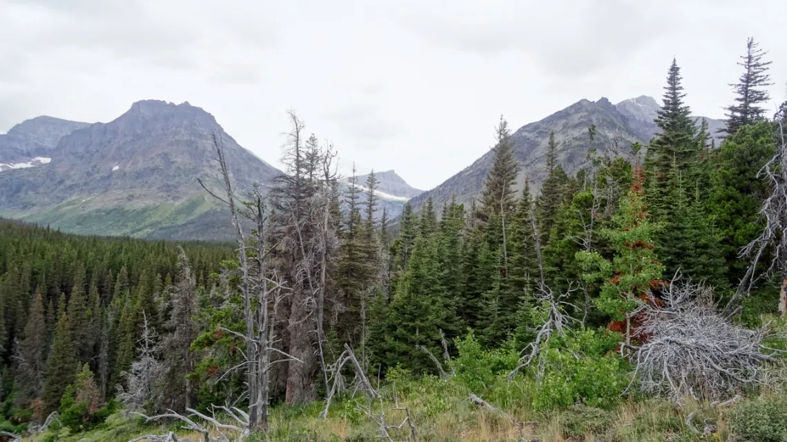
Looking around the big map we can see other hike candidates. In the northwest corner we could use Kintla Lake campground and hike along the lakeside as far as we wish. South of that is the road to Bowman Lake campground; then east there is a loop route going to Quartz lakes and a bit along Quartz Creek.
Just north of Apgar visitor center there is Fish Creek campground across Lake MacDonald from Going-to-the-Sun-Road, and a trail along that side of the lake. Off Going-to-the-Sun-Road up Lake MacDonald there is Sprague Creek campground with some hikes up creeks, believe I did some of that. And yet other stuff of course.
by Kevin Hartley, Sierra Club Life Member
Outings: The Call of the Wild
Visit the Alamo Sierra Club Outings page on Meetup for detailed information about all of our upcoming Sierra Club Outings.
The Alamo Sierran Newsletter
Richard Alles, Editor
Published by the Alamo Group of the Sierra Club, P.O. Box 6443, San Antonio, TX 78209, Website.
The Alamo Group is one of 13 regional groups within the Lone Star Chapter of the Sierra Club.
Changed your contact information?
If you're not sure whether the Sierra Club has your current email address, send an email to Member Services with your name and address and/or member ID (see Locating Your Member ID) so they can add your email address to your member record.
Have you moved? Let us know by sending your old address, your new address and your member ID to: address.changes@sierraclub.org.
Go online for the latest news and events
 |