Is San Antonio Entering a New Drought of Record?
Current conditions are raising the question: Are we entering a new drought of record? A “drought of record” is the worst recorded drought since compilation of meteorologic and hydrologic data began. The drought of record is used as a historical benchmark for planning for future water supplies. Today’s drought is similar to the existing, infamous 1950s drought of record, when the Edwards Aquifer water level fell to an all-time low of 612.5 feet in August 1957.
Steven Siebert, Manager - Water Resources at SAWS, was quoted in an October 2024 San Antonio Report:“We overlayed the 2020s drought with the 1950s drought, and if it wasn’t for the rainfall that we experienced in 2021 — we would be well below the historical level where we were at this point in the drought of record for year five in the 1950s.”
The city has endured six consecutive dry springs, and San Antonio’s primary water source, the Edwards Aquifer, has dropped to its lowest water level since 1990 when it was 622.7 feet. The day this article was written (May 20, 2025), the Bexar J-17 well recorded an aquifer water level of 624.3 feet . Since late 2019, rainfall has been well below average, and 2022 was the city’s second driest year on record .
May is typically the wettest month in San Antonio, with an average of 3.5 inches of rain and 9.2 rainy days. So far, as of May 20, less than 0.2 inches of rain has fallen in May.
As a result, the San Antonio is in an Exceptional Drought area, the worst of five categories of drought. The current high temperatures aggravate the situation by increasing human water consumption, evaporation from water bodies, and transpiration of the water in the ground.
The Sierra Club’s legal action in 1991 was the catalyst that forced Texas to create the Edwards Aquifer Authority (EAA) in order to maintain spring flow needed for the survival of endangered species. The EAA’s establishment is a prime example of how environmental advocacy and litigation can drive significant policy change to protect critical natural resources.
Interestingly, recent research suggests that San Antonio, and other cities, are actually sinking due to excessive groundwater pumping.
While San Antonio is better prepared than in the past, thanks to diversified water sources and proactive conservation, the ongoing drought is stressing local water supplies and infrastructure. Whether this becomes a new drought of record will depend on future rainfall, but the city is already facing historic water scarcity and must remain vigilant in conservation efforts.
by Bill Barker, Alamo Group executive committee member
NO KINGS Mass Protest
In America, we don’t put up with would-be kings. NO KINGS is a national day of action and mass mobilization in response to increasing authoritarian excesses and corruption from Trump and his allies. We’ve watched as they’ve cracked down on free speech, detained people for their political views, threatened to deport American citizens, and defied the courts. They’ve done this all while continuing to serve and enrich their billionaire allies.
🚨On Saturday, June 14, we’re taking to the streets nationwide. We’re not gathering to feed his ego. We’re building a movement that leaves him behind.🚨
Saturday, June 14th
5 to 8 pm
Travis Park
On April 19, thousands of people joined the protest in the streets of San Antonio. We will keep up the pressure till the lawless administration hears us and know we are determined to win this fight. We can accomplish that if we keep growing the numbers in the streets. We want to double the number of people we saw in in San Antonio on April 19.
Join us. Bring your friends to take back our country.The flag doesn’t belong to Donald Trump. It belongs to us. We’re not watching history happen. We’re making it.
On June 14th, we’re showing up everywhere he isn’t—to say no thrones, no crowns, no kings. Check out nokings.org for more information.
A core principle behind all No Kings events is a commitment to nonviolent action. We expect all participants to seek to de-escalate any potential confrontation with those who disagree with our values.
How to prepare
✅ Bring signs or props → Make your message visible! (Ideas: “NO KINGS IN AMERICA!”, “THE PEOPLE UNITED”, “NOT YOUR PIGGYBANK!”) ✅ Recruit friends → The more people, the more power. ✅ Record everything → Post photos/videos with #NoKings
🚨 We’re fighting for democracy. Let’s make them listen.
by Alamo Group Political Committee
Musk's Neo-Nazi Roots
Warren Brown of the Express-News did an excellent job of laying out some of the white supremacist and neo-Nazi actions of Elon Musk. “A Legacy Built on Democracy’s Rubble”, 03/30/25. It turns out Musk was raised with those ideologies.
Journalist Chris McGreal, formerly with the Guardian in Johannesburg, has done a background investigation of Elon Musk and his family. (McGreal was interviewed on Democracy Now! Recently) Musk’s maternal grandfather, Joshua Haldeman, was the leader of the Canadian fascist organization, originally called Technocracy, Inc., in the 1930s. After Canada joined the Allies against Hitler, Haldeman was briefly imprisoned for his pro-Nazi advocacy. Attracted to the white supremacist apartheid regime, Haldeman moved to South Africa in 1950.
Musk’s family became very wealthy from the mining business, which used apartheid oppression to maximize profits. Musk spent his first 18 years benefiting from the fascist apartheid regime and moved to the United States in 1988. His PayPal partner and fellow right-wing billionaire, Peter Thiel, was also raised in a pro-Nazi German section of South Africa during apartheid.
It’s no wonder that Musk raised his arm in the Nazi salute when speaking to the far-right AfD party in Germany recently, and that he and his platform X consistently use his great power to support fascist policies here and around the world.
Americans should be alarmed.
by Darby Riley, Alamo Group Political Chair
Glacier National Park, Northern Montana — a Tiny Glimpse #1
Piles of spectacular day hikes and backpacks in many sections of the park. Here's the National Park Service website and from there a high resolution PDF map. Under the Things to Do/Hiking and Camping pages there are park area maps and info about campgrounds. From Things to Do there are also History and Culture and Nature tabs. From the latter for example there is the Glacial Geology page.
The park area maps have more detail than the big map including trail mileages. So we download the big map and study the areas, making notes about the trails and campgrounds, planning a trip or three. An excellent resource is HikingInGlacier.com; hikes are indexed by name/area/difficulty/features; plus photos, comments and snips of the park maps. In the July issue there will be article #2 about more spots in the park.
The maps show the Continental Divide and the many trails that go up to the divide and across. So might plan particular hikes up to the divide for the pictures, a few such are mentioned below. A Wikipedia article about Watersheds of North America includes a map of the six continental divides on the continent, with the Continental Divide referred to as the Great Divide, which seems more appropriate.
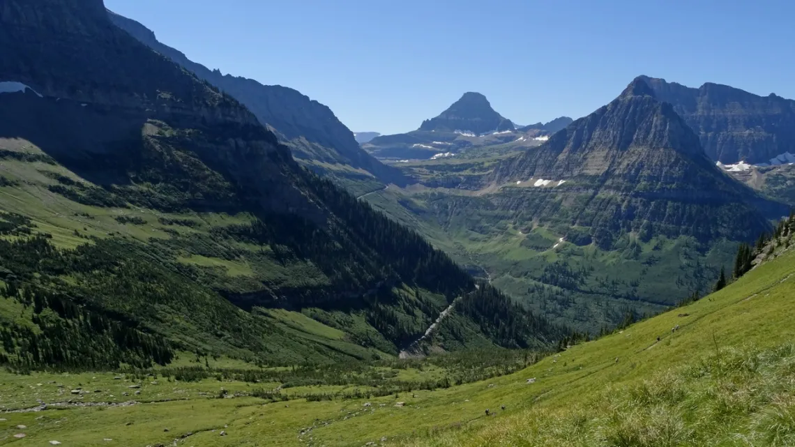
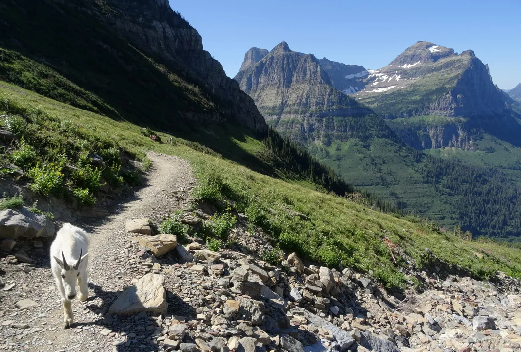
The most busy entrances are past the Apgar (west side) and St. Mary (east side) visitor centers. There are also the Two Medicine (southeast), Many Glacier (central east) and Pole Bridge (northwest) entrances. One trip I had camped at Apgar campground and wanted to take the shuttle to Logan Pass visitor center on the Continental Divide, but was booked up. Managed to drive up and park at the sharp bend halfway up Going-to-the-Sun-Road (Granite Park Chalet trailhead), then do the Highline trail to Logan Pass and back, first two pictures. Here is the St. Mary area page with map showing the above.
Park access and services may be significantly limited this summer due to NPS staff and funding cuts by the current administration. We are happy to have had such experiences as these earlier.
A couple hikes from the Many Glacier area
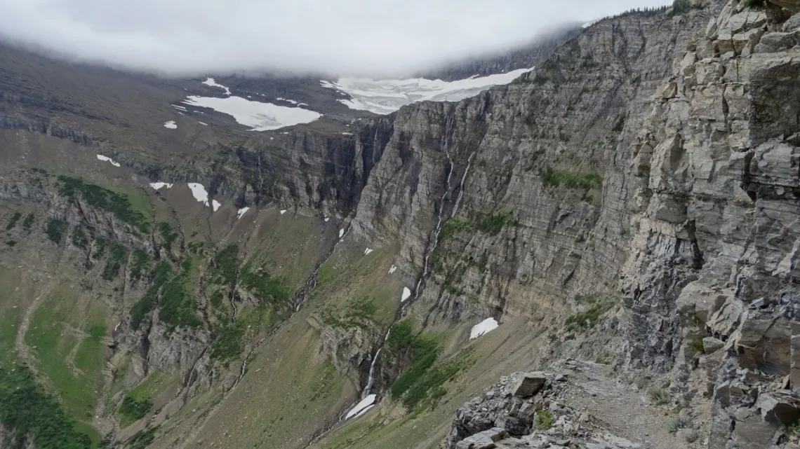
These are via the Many Glacier entrance. Here is the Many Glacier area page with map. From the Many Glacier campground I hiked up/back to Swiftcurrent Pass (next two pictures). looking at the map can see that is on the Continental Divide, and just a little further W is Granite Park Chalet and the Highline trail. Looks like the pass is about at the N end of Garden Wall.
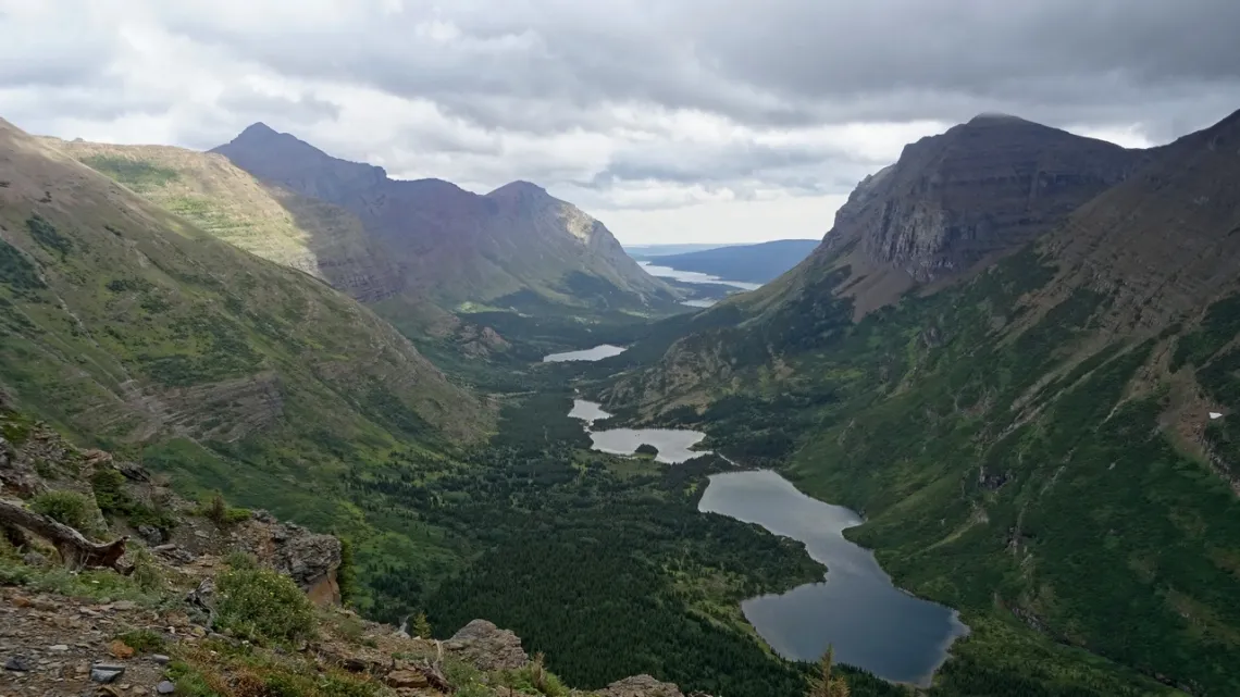
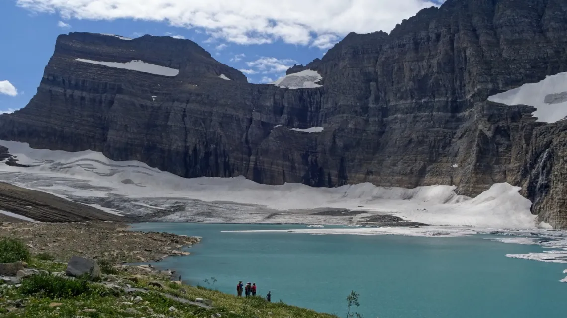
Also from Many Glacier campground there is a popular trail to Grinnell Lake with the remnants of Grinnell Glacier (next picture). So we wonder what did this look like 100 years ago before the major impact of greenhouse gases? Wikipedia has a good article with dated pictures. Mentions Salamander Glacier (another article) which used to be attached to Grinnell. Correlating this picture and couple more with the ones in these Wikipedia pages was able to identify the ice on the far side of the lake as Grinnell Glacier and the bit hanging down upper right as Salamander Glacier. In the pictures taken early 20th century the lake doesn't exist and everything is one huge glacier.
by Kevin Hartley, Sierra Club Life Member
Outings: The Call of the Wild
Visit the Alamo Sierra Club Outings page on Meetup for detailed information about all of our upcoming Sierra Club Outings.
The Alamo Sierran Newsletter
Richard Alles, Editor
Published by the Alamo Group of the Sierra Club, P.O. Box 6443, San Antonio, TX 78209, Website.
The Alamo Group is one of 13 regional groups within the Lone Star Chapter of the Sierra Club.
Changed your contact information?
If you're not sure whether the Sierra Club has your current email address, send an email to Member Services with your name and address and/or member ID (see Locating Your Member ID) so they can add your email address to your member record.
Have you moved? Let us know by sending your old address, your new address and your member ID to: address.changes@sierraclub.org.
Go online for the latest news and events
 |