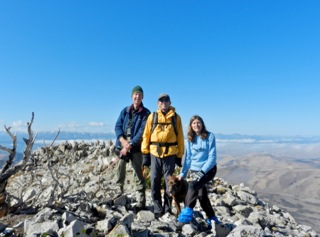
We left Reno at 4:00 pm planning to arrive at the trailhead in the Sweetwater Mountains before dark to camp and get an early morning start on the trail. Our group of seven had dwindled to three hikers: myself, Larry Grant, Larry Dwyer, plus my dog Tioga. We followed the driving directions and hiking route from Bob Sumner’s book Hiking Nevada’s County High Points. Driving south from Wellington, the turn off from NV SR 338 was not marked. The Nevada Road & Recreation Atlas enabled us to see that our right turn onto Riuse Road (#050) was shortly after the left-sided Nye Canyon sign.
I’d recommend high clearance vehicles on the last rough rocky dirt road that heads up to the corral, even though Larry D. drove his Subaru Outback all the way without a problem. We arrived at the corral (7,520’) at last light. Away from city lights, we enjoyed phenomenal stargazing.
In the morning, we started up the cold frosty trail at 7:45 am. Pinyon and mountain mahogany surrounded us at the start of the canyon, but towards the saddle we rose to a brushy open area. As we ascended we could see the valleys below filled with white puffy clouds and wispy clouds drifted around us. Precipitation had been forecast for that afternoon. At the Northeast Ridge (Lyon County High Point, 10,560’), I mistakenly took us to the higher cairn that marks the Von Schmidt line. Here we signed this register, then later returned to the Lyon CoHP on the way down from Middle Sister to sign its register. I had even been warned not to make this mistake!
On the summit of Middle Sister (10,854’), we had a nice 360-degree view since most clouds had lifted. We took pictures of the Sierra and Sweetwaters and then found shelter in the trees out of the cool breeze for lunch. After lunch, we hiked back down to the Lyon CoHP to find and sign the register. We descended a different route after Larry G. spotted a vague road that headed back down the canyon we had skirted above on the way up. The descent wove through sage and mahogany with no bushwhacking. However, it won’t take long before this vague road gets totally overgrown.
On a day with more time and no worries of a possible storm, it would be easy to also summit East Sister. We returned to the vehicles without the forecast precipitation and arrived back in Reno by 5:00 pm.
October 24, 2011 By Sharon Marie Wilcox
Route Information - Use this link to Bob Sumner's guidebook. Be sure to check his Update Section for any recent information on the routes. http://www.nevadahighpoints.com/
Photo Credit: Summit of Middle Sister 10,854' Sweetwater Mountains -- Larry Dwyer, Larry Grant, Tioga, & Sharon Marie WIlcox (photo by SMW)