Article by Lynn Boulton, Chair, Range of Light Group. Photo credit Bob Wick/BLM
Wednesday, May 25 at 1pm the Nevada State Engineer will be inviting public comments on Order 1330 for regulating the Amargosa Groundwater Basin. Order 1330 would use the 2020 USGS groundwater model, DV3, to determine the amount of groundwater extraction that would be allowed in the basin. The main resource that the state wants to protect is Devils Hole in Death Valley National Park in Nevada. A 1976 Supreme Court order prevents the water level in Devils Hole to drop below a minimum threshold. However, there are other natural resources that should be protected on the California side of the Amargosa Basin, i.e., the springs that feed the Amargosa River.
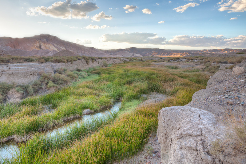
The Amargosa River starts at almost 4,000 feet at Pahute Mesa in the Nevada National Security Site (NNSS) and ends in the Badwater basin, in Death Valley National Park, California at 282 below sea level. It flows through Beatty, then southwest into California to Dumont Dunes where it bends and flows north to Badwater. The river flows underground most of its 185 miles, but surfaces around Beatty and in the Amargosa Canyon near Tecopa. The section between Shoshone and Dumont Dunes was recently designated a Wild and Scenic River.
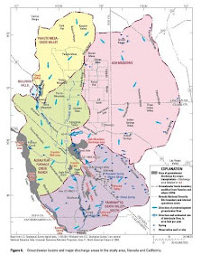
Groundwater travels easily through carbonate strata, which hydrologically connects basins below the surface. Groundwater flows from the Pahute Mesa to the Amargosa Desert and to the Ash Meadows National Wildlife Refuge (NWR). Groundwater also comes from the Spring Mountains and the Sheep Range and flows to the Ash Meadows NWR.
Groundwater also flows from Ash Meadows to Furnace Creek providing 40% of the discharge at Furnace Creek. The water travels through the Amargosa Desert and into/through the Funeral Mountains. The Ash Meadows and Furnace Creek basins are so hydrologically connected they could be considered one basin. Groundwater pumping in Amargosa Desert can affect Furnace Creek springs.
There is also a groundwater flow through carbonate rocks and basin fill from the Spring Mountains to the Amargosa River near Tecopa, and the Amargosa Canyon. So, pumping in Pahrump Valley impacts the springs in the section of the Amargosa River that has been designated as Wild and Scenic in California.
While the DV3 groundwater model is a good tool, water rights have already been allocated on the Nevada side and groundwater pumping is impacting the springs on the California side. Springs and groundwater monitoring is needed on the California side to measure the impacts. Thresholds need to be worked into the Nevada’s groundwater management plan that, when exceeded, will trigger reductions in groundwater pumping in order to maintain spring flows along the river on the California side. If you are interested in this topic, I encourage you to attend the public hearing on May 25 or submit comments.