Introduction by Emi Okikawa
In 2018, I moved from Washington, D.C. to Seattle to start a new job at the Washington State Chapter of the Sierra Club. On my flight west, I remember exploring Google Maps, navigating haphazardly over some of the different neighborhoods in my new city -- Beacon Hill, Central District, Capitol Hill, Chinatown-International District, and Fremont. At that time they were just names to me. But now, having lived here for almost three years, I’ve grown to appreciate the distinct personalities and histories of each neighborhood.
As a Japanese-Filipina, I’ve spent a good deal of time in the Chinatown-International District. I’ve frequented dimsum restaurants and boba cafes, taken Japanese language classes, and attended activist events at the Wing Luke Museum of the Asian Pacific American Experience (also known as “the Wing”). But it wasn’t until I worked on the Redlining Heritage Trail that I came to understand the deep history embedded in Seattle’s city planning, and how it has affected the communities I’ve grown to know and love.
In 2018, the Wing partnered with the National Park Service and the Northwest African American Museum to create an urban trail that physically connected the two sister museums and told an important story about a process that affected both Seattle’s Asian-American/Pacific Islander and Black communities -- redlining. It was through this project that I began my deep dive into the history of Seattle and how the effects of redlining and racist urban planning practices continue to impact the city to this day.
The goal of urban planning should be to maximize the health, safety, and economic well-being of all people living in our communities, but that hasn’t always been the case—in fact, far from it.
At its inception, modern urban planning in the United States followed the European model of focusing on public health, taking steps like separating industrial and residential uses. However, American planners quickly began using zoning as a tool for segregation. The city of Baltimore enacted the first racial zoning ordinance in 1910, and in just a few years, the practice became widespread in the greater Baltimore region. These initial attempts at segregation were crude and presented an obvious conflict with the 14th Amendment.
In 1917, the Supreme Court ruled against explicitly race-based zoning ordinances in Buchanan v. Warley (1917), but it left the door wide open for more surreptitious ways of keeping communities segregated. While the Supreme Court case was still pending, the city of Berkeley, California, adopted a loophole for the 14th Amendment that kept neighborhoods segregated without explicitly mentioning race.
Berkeley’s ordinance created residential districts that banned all apartments and even duplexes, creating a major barrier for the people and families of color who desired to live in those districts. In effect, only people who could afford a mortgage were allowed to live in wealthier neighborhoods, effectively keeping them exclusively white. Shortly after the Berkeley ordinance was adopted, a California real estate magazine bragged that it would create a whole new neighborhood that would reliably exclude Black people and Asian people.
After the Supreme Court ruling, Berkeley’s method of segregation spread quickly around the country, and by 1928 the Hoover administration had encouraged every city to adopt it. In 1934, the Federal Housing Act created both the federally backed 30-year mortgage and “redlining,” the mapping exercise that determined the areas where people would have access to federally backed mortgages. This dramatically expanded the ranks of people who could afford a single-family home, while carefully reserving that right for white people. Redlining encouraged white people in “greenlined” areas to become homeowners, while denying access to mortgages to people who lived in redlined neighborhoods.
The result of redlining wasn’t just to segregate; it also served to impose blight on neighborhoods where people of color lived. The pattern of discrimination established by the Federal Housing Administration maps was reinforced over and over by discriminatory public investment in schools, water and waste water systems, transportation systems, and other public investments that favored greenlined areas at the expense of redlined areas.
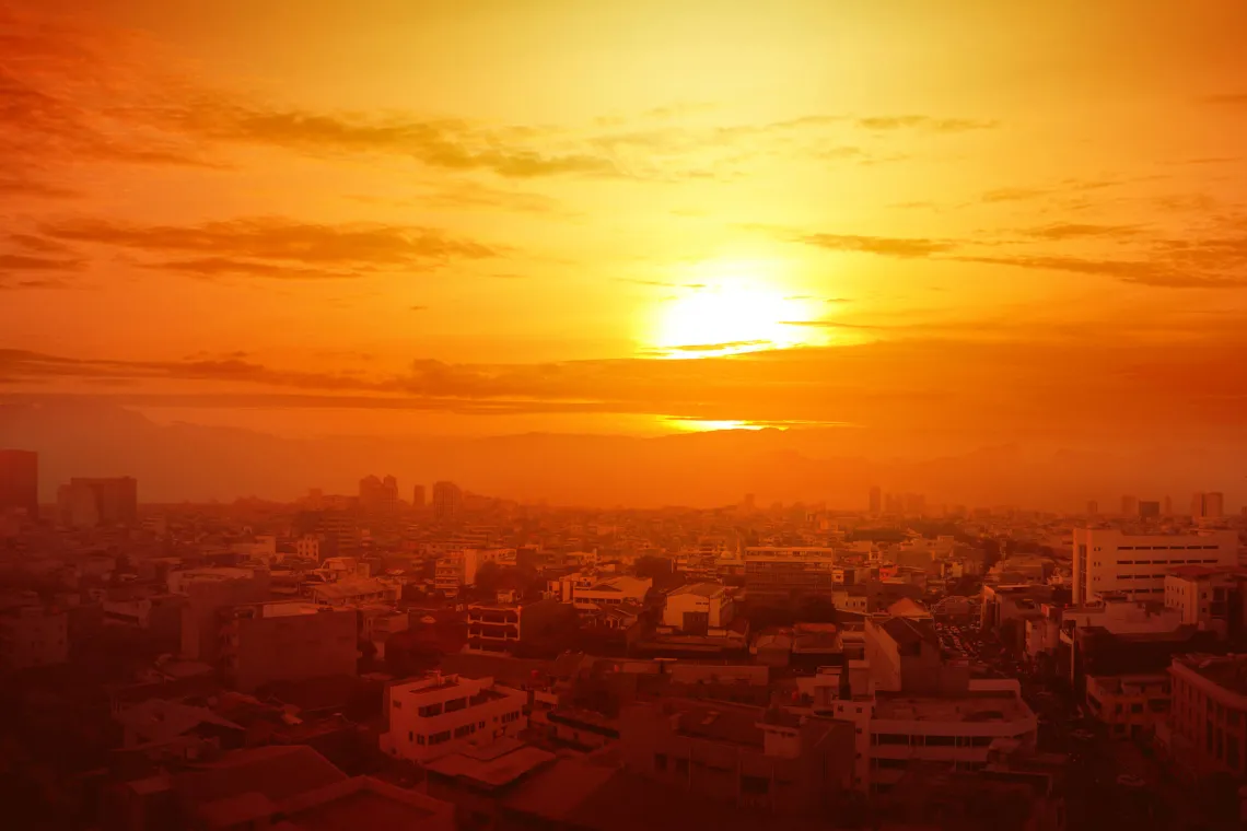
As a result, more than a half century after the federal government ended the practice of color coding our neighborhoods, the contours of segregation in America remain as entrenched today as they were a hundred years ago. We see evidence of this every day. Historically redlined neighborhoods lack street trees to this day, leaving residents sweltering and with fading biodiversity. Greenlined neighborhoods (i.e., the suburbs) tend to be auto-oriented spaces that are unwalkable and lack accessible public transportation services. This setup encourages sprawl, which is one of the main contributors to climate change.
The Redlining Heritage Trail hopes to provide impetus for residents to explore unfamiliar areas of Seattle, share stories of community resilience, and learn about the layers of history underfoot.
Many people view environmental issues as occurring in non-urban areas, far outside the city limits. But hiking trails, city parks, and public transit are all part of our environment. Protecting the urban environment and safeguarding the health of urban communities is every bit as important as protecting our national parks and wilderness areas-- especially for residents of the frontline communities who disproportionately bear the brunt of climate change in the form of extreme heat, flooding, toxic emissions from nearby industry, to name just three. We cannot tackle the climate crisis without taking a hard look at our cities and how sustained inequities lead to environmental degradation.