Campgaw Mountain - Beginners Hiking Guide
By: Mike Depardieu
Published December 2020
The purpose of this write up is to give the beginner hiker and their families enough information and guidance to decide if Campgaw is a place they would like to visit for a few hours of hiking. Please note, there are resources available such as Alltrails and other web-based reviews which are certainly good for you to read as well. For example, here is a really great detailed walkthrough of Campgaw: https://njurbanforest.com/2015/07/05/hiking-campgaw-mountain/
Preparation
I am not going to cover this in too much detail, but I would recommend for at least one person in the group to take a backpack that can carry water, extra layers, snacks, and anything else you may need. Wear some reasonable footwear of course such as an old pair of sneakers Also, please remember to take your garbage back out with you.
Location
Located in Northern NJ, Campgaw is accessible from NJ Route 17 as well as Interstate 287. It is part of the property of the Campgaw Mountain ski area. One important thing to note is that when you approach the fork in the road that leads to the ski area, stay left and follow signs to the maintenance area, which is where the hiker's park. Here is what the road looks like:

Deciding which Trails to Take.
Please refer to the pdf map: https://drive.google.com/file/d/1SjacHdyGtbdfw9oZ-2G7kUef06sFDrIU/view?usp=sharing.
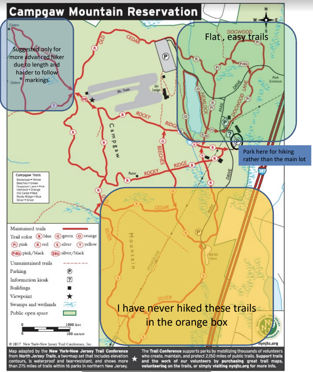
I have marked up the map with some recommendations depending on whether you would like to just explore flat terrain, or challenge yourself a bit more with a hike that takes you to the top of the hill. At Campgaw, it is always easy to just turn around and “go back to start“ at any point you want out.
If you have clicked on the two links above and are still interested in checking out the hiking. Read on!
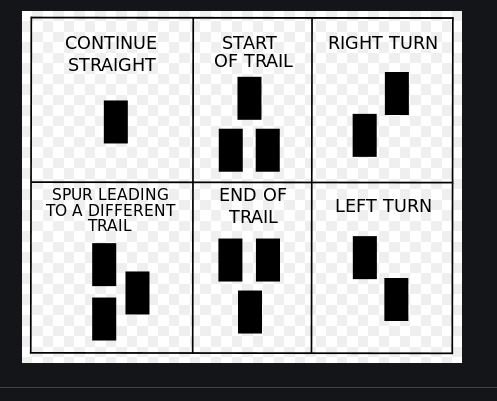
Trail Basics: Blazes and Colors
Campgaw trails are very straightforward, just follow the colors! You will soon figure out the turn right and turn left markings as shown below. At Campgaw, it is hard to get lost, as the trails all circle back, so the biggest risk is generally just a longer (or shorter) walk than you expected.
It is super helpful to have the pdf map with you as you hike! Also, you can download an app like Alltrails on your smartphone or just use any GPS map on your smartphone if you have one. But that is up to you.
Flat Terrain
Please refer to the pdf map where I have circled these trails. These are the pink and orange trails. They are each less than a mile long and as you can see, they circle back to the “maintenance” parking lot. They are flat trails, and easy to follow. A great introduction or just a good warm-up. You may see the sign below as you enter some of the trails.

Here is a picture of the lake that is circled by the orange trail. I took this on December 10, 2020, at 2:30 PM.

A Trip to the Top
If you want to see this cool view, you will need to hike to the top. There are a number of ways to get there. A rough estimate is about ½ mile trip up and about the same distance down, unless you take a longer trail. For example, the sign above shows the total length of the red trail at 2.1 miles. I haven’t done that full loop yet.

l. My favorite way is to take the blue trail BEARING RIGHT at the start. See the image below for the blue trailhead(the three blue squares in a triangle formation). Then you simply follow the trail markings.

This will take you through the frisbee golf course where you may actually see some people playing frisbee golf. When you get towards the top, you follow the trail that is marked both red and blue, as shown, to get to the top of the lifts. You have made it! Take in the view for as long as you like!
For your return trip down you can retrace your steps, or go around the red trail on the other side of the ski lifts and follow that back to the flat section by the lake. There is more frisbee golfing on that side too.
That just about sums it up for the Campgaw hiking trip. I hope that this short write up inspires you to give it a try. Even if you decide not to climb the hill!