Protected Public Lands Are Still the Backbone of America at 250
This uniquely American ideal—that wild places be protected and free to all—remains a defining legacy

Merced River, Yosemite National Park. | Photo courtesy of Visit California, More Than Just Parks
As the United States turns 250, now is a great time to think about what makes the country what it is. Public protected lands are a big part of that story.
In 1872, Yellowstone became the first official national park in the United States, and the first to be designated as that in the world. But the story of land preservation goes back further. In 1864, Mariposa Grove and Yosemite Valley (both within what is now Yosemite National Park) became the first federally protected places in the United States when President Abraham Lincoln set aside the land for “public use, resort, and recreation … inalienable for all time.” What makes this landmark legislation even more impressive is that it was enacted during the Civil War. Even further back, what is now Hot Springs National Park was set aside in 1832 to preserve and distribute hot water before eventually becoming a formal national park in 1921.
Today, 640 million acres—nearly one-third of the United States—is designated as federal public land, managed by the National Park Service, the National Forest Service, the Bureau of Land Management, and the Fish and Wildlife Service. Here is just a small sampling of our nation’s majestic national parks and public outdoor areas to celebrate and visit during America’s semiquincentennial.
Yosemite National Park
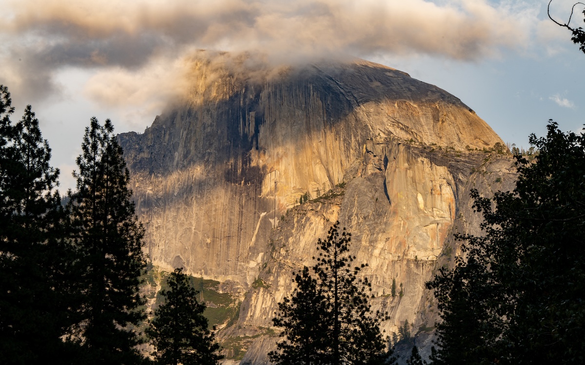
Half Dome, Yosemite National Park. | Photo courtesy of Visit California, More Than Just Parks
Yosemite National Park remains one of the most popular national parks in the world, drawing travelers to its famous waterfalls, valleys, viewpoints, and sequoia groves. Yosemite is packed in summer, when about 40 percent of its annual visitors arrive. So consider planning your trip for another time, like fall. When you visit, leave your car in the lot and take advantage of the park’s shuttle bus system to easily access many trailheads and scenic viewpoints, such as Vernal and Nevada Falls (accessed via several steep trails to the top), and El Capitan (a destination for serious rock climbers and photographers alike). About an hour from Yosemite Valley is Mariposa Grove, where you can park and take a shuttle to see over 500 giant sequoias). Much of the park can be explored by bicycle, or take a raft onto Merced River (you can rent one from Curry Village). For interpretive and ranger-led programming about nature, birding, art, and photography, check out the Talks, Tours and Events calendar. For slightly smaller crowds, head to Tioga Pass—stop at Olmsted Point for sweeping views of Half Dome, Tenaya Canyon, and the high country. Nearby May Lake offers a relatively easy hike to a beautiful alpine lake beneath Mount Hoffman. Farther east, at Tuolumne Meadows you can see a completely different side of Yosemite, with wide-open meadows, the Tuolumne River, wildlife, and excellent hiking. Lembert Dome is a favorite for its short, rewarding climb and panoramic views. For more serious hikers, Tioga Pass is also where you can access trailheads to remote wilderness areas that few visitors ever see.
Cuyahoga Valley National Park
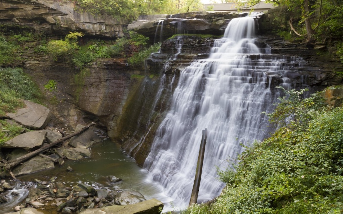
Brandywine Falls, Cuyahoga Valley National Park. | Photo courtesy of Destination Cleveland
The 33,000-acre Cuyahoga Valley National Park, just 30 minutes from Cleveland, now stands as a testament to five decades of conservation, restoration, and public investment. Its lands were once defined by industrial pollution and a river so contaminated it famously caught fire. Today, the Cuyahoga River supports more than 65 fish species. Beaver Marsh has been transformed from a 1980s junkyard into a thriving 70-acre wetland where beavers, herons, turtles, and other wildlife flourish. Visitors can experience this remarkable comeback along 125 miles of trails leading to waterfalls, wetlands, forests, and scenic overlooks, including the 60-foot Brandywine Falls and the panoramic Ledges Overlook. The park's revival is also celebrated aboard the historic Cuyahoga Valley Scenic Railroad, one of the nation's oldest excursion railways and one of the only heritage railroads operating entirely within a national park. Home to more than 250 bird species, including bald eagles that returned to nest in the park in 2006, Cuyahoga Valley National Park demonstrates that America's greatest conservation victories are not always about preserving untouched wilderness, but about restoring damaged landscapes into vibrant public spaces where nature, history, and communities can once again thrive.
Acadia National Park
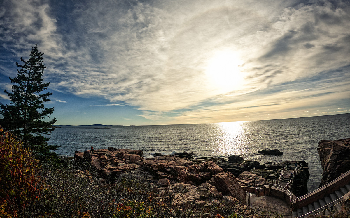
Otter Cliff, Acadia National Park. | Photo courtesy of Maine Office of Tourism
Acadia National Park stands out not only for its dramatic meeting of mountains and sea but also for its forward-looking approach to making one of the nation's most beloved public lands more accessible and sustainable. The recent opening of the Acadia Gateway Center marks one of the park's most significant visitor improvements in decades, with an expansive new visitor center, EV charging stations, and direct access to the free Island Explorer shuttle, allowing hundreds of thousands of visitors each year to leave their cars behind while reducing congestion. That commitment to car-free exploration makes Acadia one of the few national parks that can be easily experienced without driving. Travelers can arrive by bus from Bangor or Portland (try Downeast Transportation or Concord Coachlines) before connecting to shuttle routes that reach trailheads, carriage roads, beaches, and gateway communities like Bar Harbor. Once inside the park, there are countless ways to explore—from hiking granite peaks at sunrise and cycling the historic carriage roads to paddling along the rugged coastline or watching waves crash against the cliffs at Thunder Hole.
Virgin Islands National Park

Trunk Bay, Virgin Islands National Park. | Photo courtesy of Virgin Islands Department of Tourism
The breezy and decidedly Caribbean Virgin Islands National Park offers a powerful reminder that America's public lands extend far beyond the continental United States. Covering nearly 60 percent of St. John Island, the park protects one of the nation's most distinctive landscapes, where tropical forests, white-sand beaches, coral reefs, mangroves, and historic sugar-plantation ruins converge in a setting unlike any other in the national park system. Visitors can hike through lush rainforest to panoramic coastal overlooks, snorkel the famous underwater trail at Trunk Bay, explore ancient Taíno petroglyphs, and discover the stories of the island's Indigenous peoples and the generations of enslaved Africans and their descendants whose resilience shaped the island's history. By preserving both extraordinary biodiversity and centuries of Caribbean American cultural heritage, Virgin Islands National Park broadens the story of America's protected lands.
Kasha-Katuwe Tent Rocks National Monument
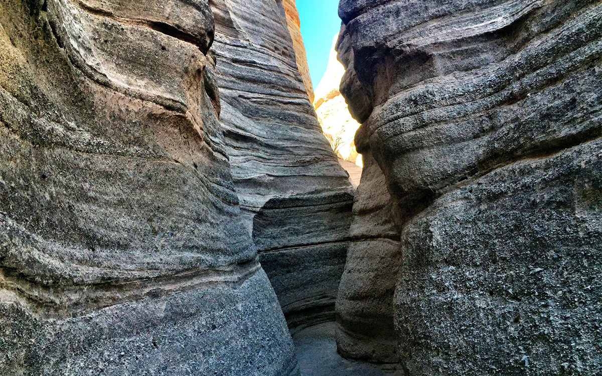
Kasha-Katuwe Tent Rocks National Monument. | Photo courtesy of New Mexico True
It’s worth remembering that America's public lands also extend far beyond its national parks. Managed by the Bureau of Land Management, millions of acres of public lands offer world-class opportunities for hiking, camping, biking, fishing, wildlife viewing, and outdoor adventure, often with fewer crowds than their national park counterparts. One of the most spectacular examples is Kasha-Katuwe Tent Rocks National Monument, located about 50 minutes west of Santa Fe. Known simply as “Tent Rocks,” the monument is famous for its dramatic volcanic hoodoos and towering white cliffs sculpted from ash, pumice, and tuff over millions of years. After a four-year closure, the monument has reopened under a new co-stewardship agreement between the Bureau of Land Management and the Cochiti Pueblo, with timed-entry reservations and Tribal Access Passes, which help to protect this culturally significant landscape for future generations. Visitors can experience the monument on a network of trails that range from the easy Cave Loop and Veterans' Memorial Trail to the more challenging Canyon Trail, which winds through a narrow slot canyon before climbing to sweeping views of the Sangre de Cristo, Jemez, and Sandia Mountains and the Rio Grande Valley. Named for the Keresan words meaning “white cliffs,” Kasha-Katuwe demonstrates how America's public lands preserve not only extraordinary geology but also the Indigenous heritage and collaborative stewardship that will shape the next century of conservation.
Yakima River Canyon
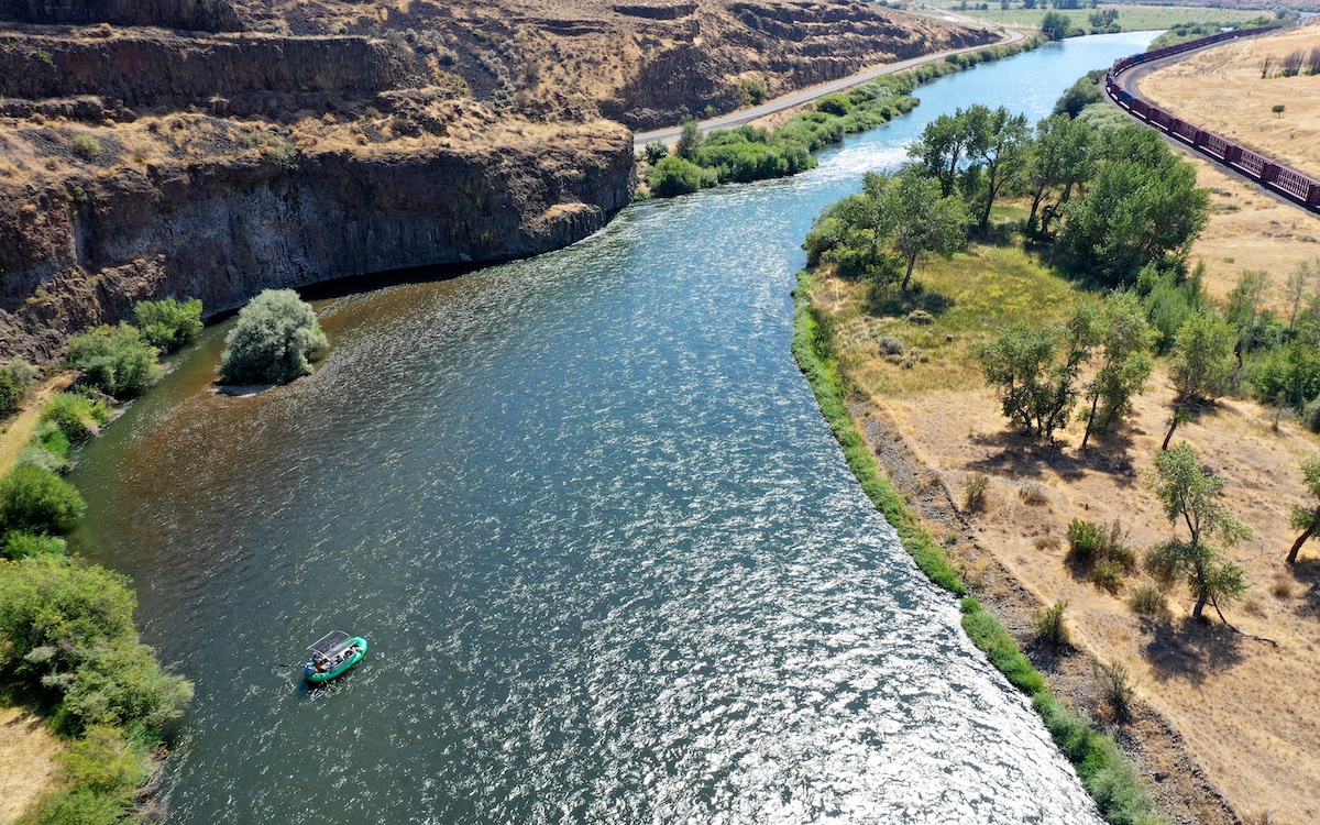
Yakima River Canyon. | Photo courtesy of Yakima Valley Tourism
America's public lands are often the product of collaboration as much as conservation, and few places illustrate that better than the Yakima River Canyon. Stretching for 27 miles between Ellensburg and Yakima, this spectacular basalt canyon is managed primarily by the Bureau of Land Management but is also protected through partnerships with the Washington Department of Fish and Wildlife, conservation organizations, and local groups like Western Rivers Conservancy and Kittitas Environmental Education Network. This partnership—to conserve wildlife habitat, improve recreation, and expand educational opportunities—has resulted in one of the Pacific Northwest's most underrated outdoor destinations. Here, visitors can cast a line on Washington's only Blue Ribbon trout stream, paddle the Yakima River by raft or kayak, hike along dramatic canyon walls, or watch one of North America's highest concentrations of nesting raptors, including golden eagles, prairie falcons, and red-tailed hawks. Designated as an Audubon Important Bird Area, the canyon also rewards visitors with expansive dark skies ideal for stargazing and meteor showers.