Vote for Prop. 4 on November 4th
Proposition 4, a Texas constitutional amendment, would dedicate a portion of existing state sales taxes to the Texas Water Fund. The Greater Edwards Aquifer Alliance supports passage of this amendment to allocate $20 billion over the next 20 years to water projects.

Here’s why. The $20 billion will:
- Fund fixing water infrastructure. Texas' aging, leaking water systems lose about 88 billion gallons of water each year - as much water used per year as the cities of Austin, Fort Worth, El Paso, Laredo and Lubbock combined. You can read more on that here and here.
- Fund wastewater improvements. The American Society of Civil Engineers gave Texas wastewater infrastructure a D minus in this year’s 2025 Report Card for America’s Infrastructure. ‘Nuff said.
- Fund water reuse projects. For Texas to meet its future water demands, the Texas Water Development Board estimates that annual reuse supplies in the state will need to make up about 15% of the state’s total water supply by 2070. We currently are at less than 5% of recycled wastewater being put to good use.
- Fund flood infrastructure projects. Those of us living in Flash Flood Alley don’t need to be convinced of the need for more funding for drainage projects. Especially appealing is the prospect of funding projects that mitigate flooding while enhancing water supplies.
- Fund new water supply projects. We especially like Aquifer Storage and Recovery (ASR) and brackish groundwater desalination projects. Other supply options, such as reuse of water produced as a by-product of oil and gas operations, ocean desalination, and building new surface water reservoirs should be subject to new rules to make sure there are no adverse environmental or human health impacts.
- A Texas Tribune analysis found that Texas cities and towns could be on a path toward a severe water shortage by 2030 if there is recurring, record-breaking drought conditions across the state and if water entities and state leaders fail to put in place key strategies to secure water supplies. This is an even bigger issue in our part of Texas where when we are not in a drought, we are between droughts.
Read BallotPedia for more information about Proposition 4.
GEAA staff and our allies worked hard to make sure Prop 4 is a great initiative that addresses our future water needs. It is our hope that all citizens of Texas will recognize the need for funding water infrastructure and supply and will vote FOR Prop 4 on November 4, 2025. Early voting – October 18th through October 30th.
by Annalisa Peace, Executive Director, Greater Edwards Aquifer Alliance
The Hot Wells Hotel and Spa
Our October general meeting features Gregg Eckhardt, Senior Analyst for the San Antonio Water System, who will talk about the storied Hot Wells Hotel and Spa.
Tuesday, October 21st
6:00 pm
Meeting schedule
| Informal get-to-know-you | 6:00 pm to 6:15 pm |
| Announcements | 6:15 pm to 6:30 pm |
| Featured program | 6:30 pm to 8:00 pm |
Venue
This is an in-person only meeting at:
William R. Sinkin Eco Centro, 1802 North Main Avenue
Map
Program topic
The Hot Wells Hotel and Spa has a long and storied history in San Antonio as a destination spot for locals and visitors to embrace hot and sulfurous water from the Edwards Aquifer. Gregg Eckhardt will draw from his large archive of rare and historic documents and images to trace the history of the site from its opening in 1892 to its present incarnation as a once-again spot for immersion in the unique and precious waters of our Aquifer.
About our speaker
Gregg Eckhardt is an environmental scientist with 37 years of experience in environmental modeling and analysis, water resource planning and development, state and federal permitting, and water treatment. He is known as The Nerd King of South Texas Water History and runs The Edwards Aquifer Website.
As Senior Analyst for the San Antonio Water System, he is involved in the planning, operations, and management of the city's water supply and wastewater.
The Alamo Group of the Sierra Club holds its general meetings the 3rd Tuesday of most months. They're always free and open to the public.
Theodore Roosevelt and Badlands National Parks in the Dakotas; and Bits About the Great Plains
In the August 2024 issue of this newsletter there was an article about Theodore Roosevelt National Park with description, photos and basic info about visiting. And a section on keystone species and ecosystem engineers. Comments here also resulting from that too-short visit in August 2020 (all the pics from that), plus other places we might visit. And some bits about the Great Plains and couple book mentions.
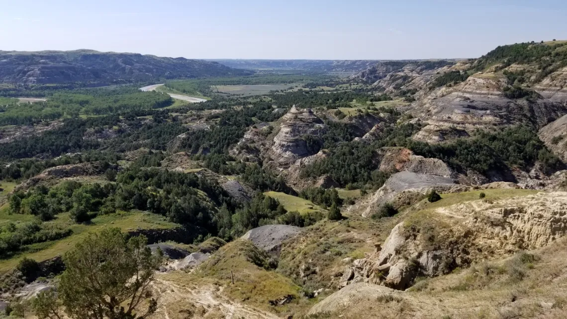
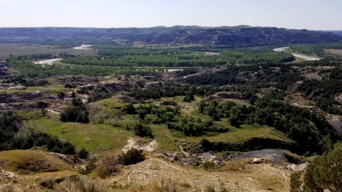
Theodore Roosevelt National Park, North Dakota
If managed to go back again surely would do more of the south unit. Then back in the north unit some of the trail along the Little Missouri River mentioned in the prior article, about the 2nd picture below. And further to that article, the loop south from the CCC campground along the river, including a bit of the Maah Daah Hey trail.
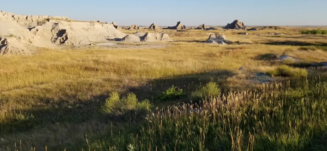
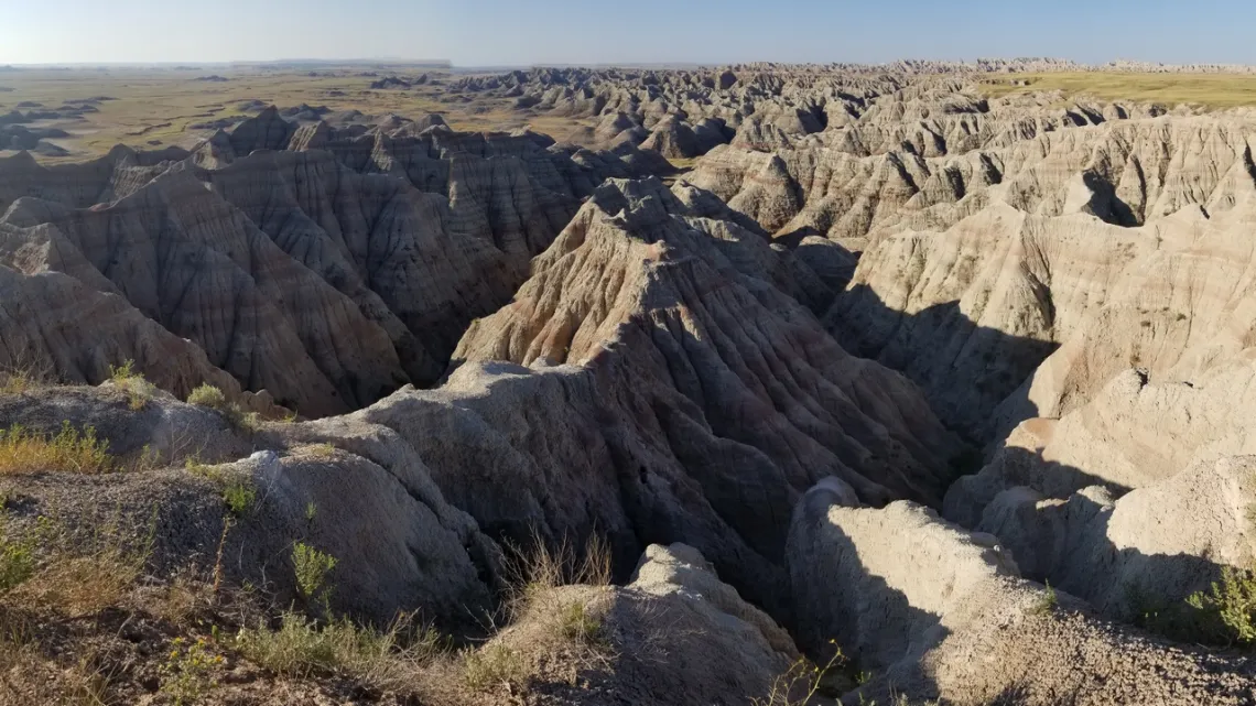
Badlands National Park, South Dakota
Here's the NPS park website with sections about the geology, history, nature and culture. For maps we go to an NPS brochures page, where we can find the official, overview and Cedar Pass detail maps. We might think the pictures below are not as appealing as the above in TR national park, but most places in the Northern Great Plains don't have a river running through them.
On the way back from TR national park we drove through the far east corner of Badlands, the Cedar Pass area. Took the pictures below and stayed at the headquarters campground. Looking at the official (detailed) map linked above, we can see the North Unit which includes Cedar Pass area and to the west Badlands Wilderness area with the Badlands Loop road running along the north side. And there is the Stronghold Unit to the south which is part of the Pine Ridge Indian Reservation. So we missed many serious scenic vistas.
Here is the park's page about the Badlands Loop road, which is hwy 240, coming in and back out from the north. Hwy 240 is what RVs would do, but there is Sage Creek Rim road which continues west and then southwest out of the park to hwy 44. Overlooks are noted on the detailed map, with Sage Creek campground (no water) the westernmost one. HikingProject.com shows the popular trails (around Castle trail, eastern area) with maps and downloadable GPX files. And: a 22 mile loop off the SW corner of the loop road, max elevation difference only 300' into Sage Creek basin, but is “a trail-less loop that follows the natural topography and geographical features in the Sage Creek Wilderness". If we are young, ambitious and well-prepared might do this as a dayhike! Or at least down into the basin, looking at the ecology and back up.
Other Spots We Might Visit in the Northern Great Plains
On the Badlands area map we can see Black Hills National Forest to the west in Wyoming. With Jewel Cave National Monument, Wind Cave National Park, Mount Rushmore National Memorial and Custer State Park on the east side of Black Hills. We did see bits of these, think we stayed at a campground in the state park.
On the Way Up and Back
Scotts Bluff National Monument, far western Nebraska just southwest of the town of Scottsbluff. Looks like interesting trails but no campground, though found Riverside campground in the southwest corner of the town.
Toadstool Geologic Park (Wikipedia), northwestern Nebraska, in Ogalala National Grassland. A limited campground with no water, but at-large camping is allowed in the national grassland undeveloped areas.
Sand Creek Massacre National Historic Site, (Wikipedia page, and another about the event itself and what happened before and after), central far eastern Colorado.
Picture Canyon in Comanche National Grassland, southeastern Colorado. Couple pictures in an article April 2021. There is Picture Canyon campground, and another at Picket Wire Corrals Interpretive Site, and dispersed camping options.
Pawnee Buttes (Wikipedia) in Pawnee National Grassland, northeastern Colorado. No campground in the area but there is Crow Valley campground also in the grassland, just northwest of Briggsdale which is southwest. At-large camping allowed in the national grassland undeveloped areas.
Book about the Great Plains: A Natural History of the Heart of North America by Candace Savage
This book is a really excellent introduction; very readable, uses common species names, not scientific, we likely can acquire a pile of memorable overview stuff. Nine chapters each with sections on specifics. There are color maps showing the range and distribution of the topics, for example Ecoregions of the Great Plains (short, mixed, tall grasslands, woodlands and savannas).
Chapter 3 is Geography of Grass. Chapter 7, Prairie Woodlands, is also about hills, mountains and rivers. Chapter 4, Secrets of the Soil, about the range of biodiversity and interdependence thereof in soils.
Chapter 5, Home on the Range, is about the animals that live here or previously did. Chapter 6, The Water of Life, about aquifers. Chapter 9, Long Range Forecast, what is happening now and what the these places will look like in the future.
Books at the SA library
The library has these three in addition to Candace Savage's above.
The National Grasslands - a Guide to America's Undiscovered Treasures by Francis Moul
Prairie Spring – a Journey Into the Heart of a Season by Pete Dunne
Sea of Grass - The Conquest, Ruin, and Redemption of Nature on the American Prairie by Dave Hage and Josephine Marcotty.
A Science Friday podcast and Wikipedia pages
A succinct podcast explaining briefly several key bits: The Ruin And Redemption Of The American Prairie. About the Great Plains. This was an interview with the authors of the last book listed above. Bits: the grasslands resulted originally from the rain shadow of the Rocky Mountains. The vast conversion of grasslands to farms resulted in destruction of soils that were 2 feet deep and the interdependent web within due to deep plowing.
But there are some farmers that understand this and are trying to mitigate. There is now a machine option that mulches crop remains and only mixes that with the uppermost soil layer while planting seeds. And other changes in practices by farmers who are more knowledgeable than previously.
Here is the Great Plains Wikipedia page. Good sections about basics, geography, the five sections (the Dakotas are in the Northern Great Plains and much of Texas is in the Southern Great Plains), geology, eco-regions, natural history, public and protected lands, history regards H. sapiens, etc.
So about Texas!
In the Wikipedia page Southern Great Plains section there are further linked pages for the Edwards Plateau in south-central Texas, the Llano Estacado in northwestern Texas and the Rio Grande river which begins in Colorado. Then there are pages linked from Llano Estacado about the Pecos and Canadian rivers, and from those pages about the European invaders and wars with Indigenous tribes in the 17th and 18th centuries. We can cruise around these piles of info and learn lots of new stuff and happily remember some bits.
by Kevin Hartley, Sierra Club Life Member
Outings: The Call of the Wild
Visit the Alamo Sierra Club Outings page on Meetup for detailed information about all of our upcoming Sierra Club Outings.
The Alamo Sierran Newsletter
Richard Alles, Editor
Published by the Alamo Group of the Sierra Club, P.O. Box 6443, San Antonio, TX 78209, Website.
The Alamo Group is one of 13 regional groups within the Lone Star Chapter of the Sierra Club.
Changed your contact information?
If you're not sure whether the Sierra Club has your current email address, send an email to Member Services with your name and address and/or member ID (see Locating Your Member ID) so they can add your email address to your member record.
Have you moved? Let us know by sending your old address, your new address and your member ID to: address.changes@sierraclub.org.
Go online for the latest news and events
 |