By Norman La Force & Jim Hanson

Richmond’s Point Molate is a unique and beautiful public resource whose future hangs in the balance. If the name rings a bell but you couldn’t place it on a map, you’re not alone; Point Molate is truly a hidden treasure. Because of its geographic isolation and lack of public amenities, few people have seen Point Molate for themselves.
Point Molate is the large, hilly peninsula jutting northward into the bay at Richmond's western edge — you’ve likely gotten a quick glimpse from the Richmond-San Rafael Bridge. The US Navy transferred the land to the City of Richmond in the mid-1990s after it closed its fuel-loading depot there. Since then, decisions about what to do with Point Molate have been mired in litigation and tainted by a city approach that has largely left residents out of the process.
This summer, the city is hosting a set of “Community Visioning” events, ostensibly to get public input on the type and location of development on Point Molate. But with an accelerated timeline, minimal advertising, and a narrow scope dictated by a legal settlement that the Sierra Club and many others consider illegal (more on that later), the process seems better designed to check off a box than to actually consider the best uses for an important public resource.
We encourage all Richmond residents to get involved and advocate for an official vision and associated zoning of Point Richmond that results in access and economic and equity gains for all of Richmond — not just private development for a wealthy few. Read more about our vision for how Point Molate can most benefit the public below.
There are opportunities for engagement around Point Molate listed at the end of this article. Meanwhile, the Sierra Club is working to ensure that the planning process meaningfully incorporates the public’s priorities.
What Does Point Molate Have To Offer?
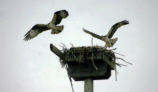 Point Molate's verdant hillsides and seasonal waterways are home to black swallowtail butterflies and native plant life of unusual diversity. Osprey have returned to nest. The shorelines host reestablished oyster beds and large, healthy stands of eelgrass — both essential to healthy Bay habitat and part of the ecological barrier protecting us from sea level rise.
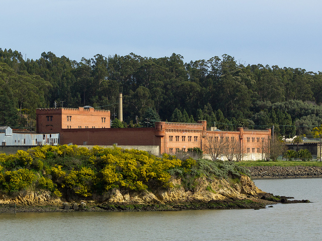
Point Molate also features numerous historic sites including a Chinese shrimping camp, the last operational whaling station in California, remnants of the World War II fuel depot for the Pacifc naval fleet, and Winehaven, a fantastic castle-like structure that was part of the largest winery in the U.S. prior to Prohibition.
How Can The Public Benefit Most?
 Point Molate’s natural and historic resources should be conserved for the enjoyment of all of Richmond. The city should explore partnerships with the East Bay Regional Park District and various land trusts to keep the area open to public recreation including cycling, kayaking, hiking, and sports fields. Winehaven should be restored as a commercial, educational, and historic destination district. Imagine a restaurant, cafe, artist space, classrooms, hotel, and conference center where people can congregate to learn from and enjoy the natural beauty and spectacular views.
Why Housing Developments Are Wrong For Point Molate
 When imagining Point Molate’s future, we must acknowledge that its location puts severe constraints on how it can and should be developed. It is far from transit and isolated by geography from job and transit centers, meaning any potential residents would have to drive themselves in and out via the one two-lane road. The site also lacks basic infrastructure like electricity and sewers, which would cost tens of millions to install and raise the costs of any housing beyond what most Richmond and Bay Area residents can afford.
The Bay Area needs more housing — but it should be built in Richmond’s urban core, near existing infrastructure, transit, and services. Infill housing in existing communities supports and stimulates Richmond’s small businesses, and is more likely to be more affordable for Richmond residents, teachers, health workers, the building trades, and others. That’s what will lead to environmental, economic, and equity gains — not housing developments at Point Molate.
The Fallout from a Long Legal Saga
Not long after the City of Richmond acquired Point Molate from the Navy, the development company Upstream, in partnership with the Guidiville Band of Pomo Indians, proposed a massive casino complex at the site. Richmond voters rejected the casino idea in 2010, voting 58% to 41% against it.
Following that clear public mandate, the Richmond City Council used its legal discretion to reject the casino project. In response, the developer sued the city for $750 million dollars, but lost its suit in federal court. The developer appealed that ruling, and this April, the Richmond City Council voted in closed session to accept a settlement agreement with the developer.
Fighting for an Open & Transparent Planning Process
 The settlement agreement reached by the City of Richmond and the would-be casino developers has several significant provisions. First, it requires at least 670 units of residential housing on up to 30 percent of the land. It also stipulates that Upstream and the city will split the profits from the sale of the land 50/50. These provisions make it clear that the “Community Visioning” process being conducted by the city this summer is being used as little more than a fig leaf for a backroom deal that has already hashed out the specifics of the plan for developing Point Molate. How can the public weigh in on land use if it’s already been decided?
Fortunately, such backroom deals are illegal as well as being bad public policy, so two local environmental groups, with the support of the Sierra Club, have now sued the city for an improper and illegal settlement.
The lawsuit filed by Citizens for East Shore Parks (CESP), the Sustainability, Parks, Recycling and Wildlife Legal Defense Fund (SPRAWLDEF), and four private citizens points out that the city violated the Brown Act open meeting law by not voting on the settlement in open session where the public could comment, and where each city council member had to state how they voted. The lawsuit also calls out the settlement’s approval of a guaranteed number of residential units on a property that has not yet been zoned.
If this lawsuit prevails, the illegal closed-door settlement would be nullified and the city would have to plan Point Molate’s future in a truly open and transparent process.
What You Can Do
Stay informed and get involved! The city has filed a motion to dismiss the environmental groups’ lawsuit. That motion will be heard on September 11th. For updates, check back on our blog.
At the same time, we encourage Richmond residents to advocate for an official vision and associated zoning of Point Richmond that results in outdoor recreation and economic and equity gains for all of Richmond — not just development for a wealthy few. The recommended vision for Point Molate will go before the City Council in October.
To that end, we encourage Richmond residents to attend the final city workshop and site tour so you can experience Point Molate’s remarkable history, culture, and shoreline beauty first-hand — and then speak up to protect these resources for all of Richmond.
The final site tour is Saturday, August 18th from 10:00 am to noon. Meet at Point Molate Building 1 at 2100 Stenmark Drive at 10:00 am, or RSVP for a free shuttle to Point Molate leaving from Richmond City Hall between 9:00 and 9:30 am.
The final workshop is Monday, August 27th from 5:00 to 9:00 pm at the Richmond Memorial Auditorium, 403 Civic Center Plaza. RSVP here for the workshop.
If you can’t join the official site tour, visit Point Molate on your own to get a sense of the space and its potential. To get there, drive east on Highway 580 toward Point Richmond. Exit at Stenmark Drive just before the Richmond-San Rafael toll plaza, and follow the signs for Point Molate. At the bottom of the first rise is a City-run Beach Park with picnic tables. Follow Stenmark Drive over the rise to the next watershed to view the old Winehaven buildings.
Note: Keep posted for the opening of a Bay Trail extension along I-580 sometime within the next year, and if you have not been to Richmond lately, consider taking some time to visit the Rosie the Riveter WWII Home Front National Historical Park, the Richmond Museum of History, and Richmond’s many small family restaurants.
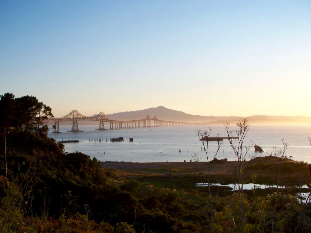
Photos from Point Molate, top to bottom: Swallowtail butterfly by TJ Gehling; Osprey taking shifts at the nest by TJ Gehling; Winehaven by Jeff; the sunset view from Point Molate by Trisha Fawver.