Santa Lucia Chapter Outings/Hikes
All are welcome! Our hikes and activities are open to Sierra Club members and the public.
Join our Meetup Group to see SLO Sierra Club Outings and reserve your spot! Join our Meetup here: San Luis Obispo Sierra Club Meetup Group (San Luis Obispo, CA) | Meetup (Or go to Meetup and search for "San Luis Obispo Sierra Club Meetup Group")
Sign-up for hikes in Meetup HERE
Meetup is a free app and website. You can signup for hikes there, get notifications when new Sierra Club hikes are posted, and get notifications for day-of changes/updates.
July 2026 Outings
Sign-up for hikes in Meetup HERE
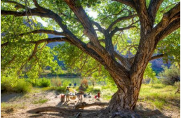
Cerro Alto and West Cuesta Ridge Loop Trail
Wednesday, July 1st, 9 am - 1:30 pm
Hiking Description: Cerro Alto and West Cuesta Ridge Loop Trail: approx. 7 miles. 1,050 ft. elevation gain. Moderate to difficult.
This hike allows you to enjoy beautiful views of the Los Osos Valley displaying the Sisters Mountains.The Canyon Trail at the east end of the parking area will take us through a lush narrow canyon with oak, sycamore and cottonwood trees. The Canyon Trail will intersect with the AT&T Cable Road and lead us to the West Cuesta Ridge Trail. The ridge trail traverses the mountain ridge with views of the coastline and the string of morros. Continuing through a beautiful eucalyptus grove the trail descends to the Boy Scout Trail and drops into the Cerro Alto Campground through a canopy of massive oaks.
Driving Directions: From Highway 101 in Atascadero, take highway 41 West/Morro Bay exit. Head 8.7 miles West to the Cerro Alto Campground turnoff. Turn left and continue 0.9 miles up the winding road to the parking lot at the end of the road. A $10 parking fee is required. Carpooling recommended.
What to bring: Dress in layers with sturdy shoes. Bring food and a minimum of 1 1/2 liter of water. Participants will be asked to sign a liability form.
For more information call: Lorrie: 805-980-8824
Rain, excessive heat or smoke will cancel the hike. `
Limited to 20 people
General rules & what to bring
- You must register in advance through Meetup.
- Bring drinking water to all outings and optionally a lunch or snacks.
- Sturdy footwear is recommended.
- Pets are generally NOT allowed.
- A parent or responsible adult must accompany children under the age of 18.
Any Questions?
If you have any suggestions for hikes or outdoor activities, questions about the Chapter’s outing policies, or would like to be an outings leader, contact Outings Chair Art Westerfield at awwesterfield@gmail.com. For information on a specific outing, please contact the listed outing leader.
National Outings
Environmentally friendly outdoor adventures around the world are available to people of all ages and abilities, whether you’re seeking lodge-based explorations or supported treks, backpack journeys or vacations nearly anywhere in the world. Go to sierraclub.org/outings, or call 415-977-5522, or contact national.outings@sierraclub.org.