The Push to Save Utah's Greater Canyonlands Region
Oil rigs and outdoor recreation clash in the canyons of southeastern Utah
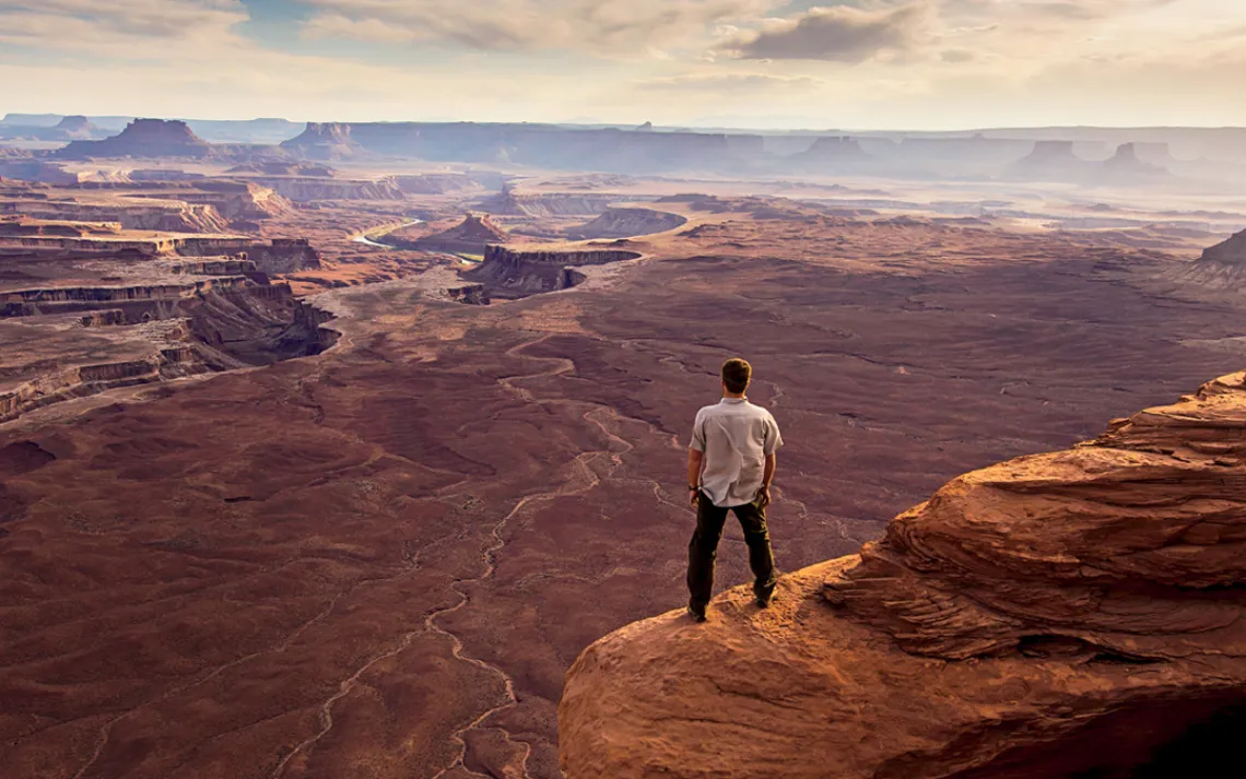
A visitor enjoys the view near Green River Overlook in Canyonlands National Park, Utah. | Photo by Dan Ballard/Aurora Photos
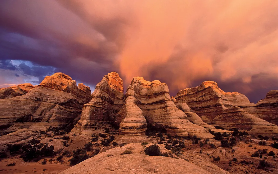
Happy Canyon in Greater Canyonlands, Utah. | Photo by Scott Melcer
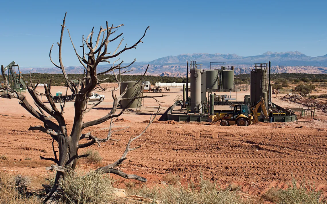
Oil and gas development along Route 313, next to Canyonlands National Park, Utah. | Photo by Julian Smith
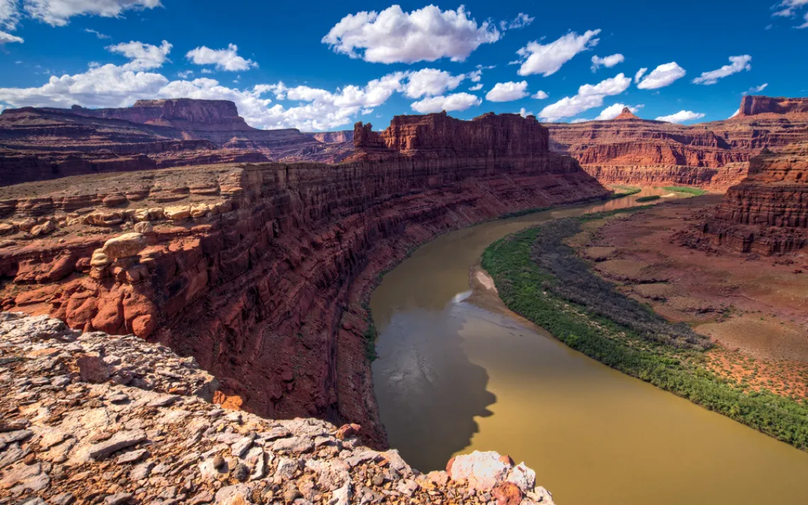
The Colorado River's Gooseneck in the Greater Canyonlands, Utah. | Photo by Jeff Clay/TandemStock
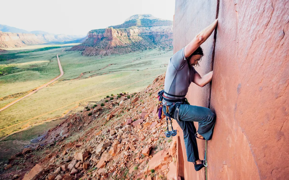
A climber ascends a wall in Indian Creek Canyon, just outside of Canyonlands National Park. | Photo by Lindsay Daniels/TandemStock
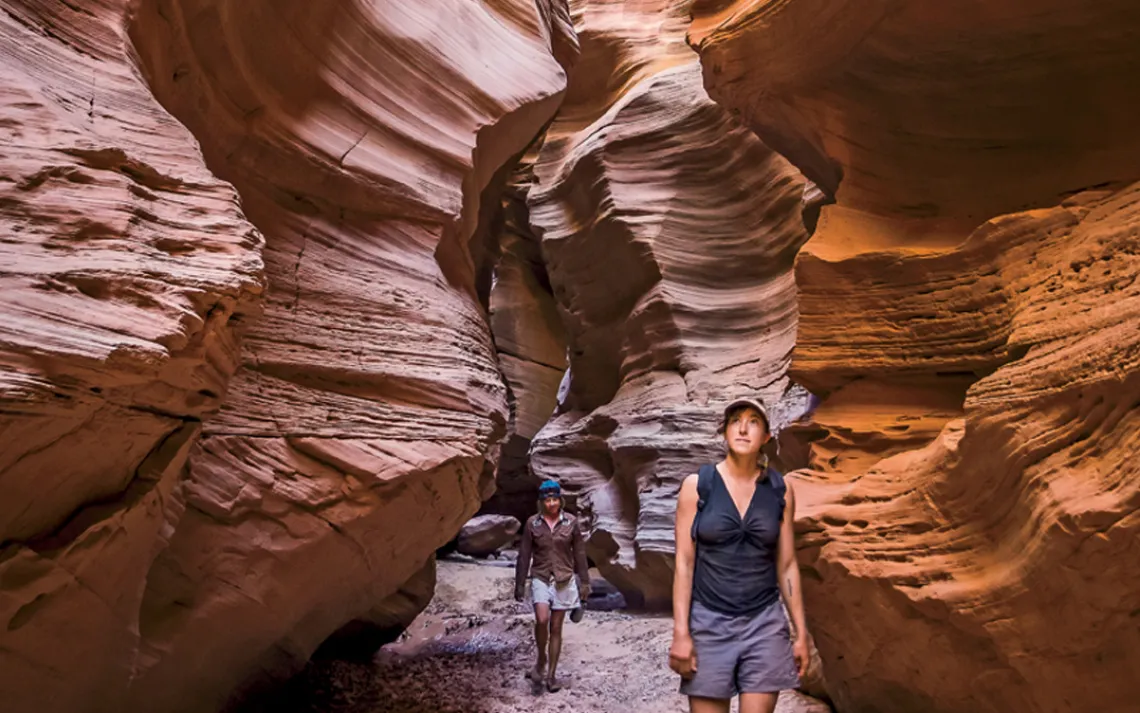
Hiking through the Fins in the Maze district of Canyonlands National Park, Utah. | Photo by Whit Richardson

Mesa Arch at sunrise, in the Island in the Sky district of Canyonlands National Park, Utah. | Photo by Stephen Matera/TandemStock
DROPS OF SWEAT FALL on my topo map as I rotate slowly, trying to match its bird nest of contour lines with the sheer sandstone walls in every direction.
I know I'm in Pictograph Fork, deep in the heart of southeast Utah's Canyon Country. North is that way. But could this ripple of elevations really be that alcove to my right, big enough to hold a building? The rust-colored tower erupting from the sandy wash looks so different from the tiny blip on the map.
And where the heck is the Harvest Scene?
I take off my sunglasses and run an arm across my eyes. It's 90 degrees Fahrenheit at noon, well above the average for late October. I have just enough water left for the steep scramble back up to the rim of the canyon, where I left most of my camping gear this morning. The panel of rock art I set out to find has to be around here somewhere.
The deep, dry canyons west of the Green River are not places you wander around in with hopes of stumbling on a familiar landmark or a kind stranger to point you toward the trailhead. Help is a long way away. People die down here.
In the stark, sunny silence, it's hard to believe that just 20 miles away as the crow flies, thousands of people are enjoying the trails, rivers, and desert overlooks around Moab. Once a sleepy mining and farming town, in recent years Moab has become a gateway for hikers, mountain bikers, river rafters, and off-road-vehicle enthusiasts. Tourism pours $141 million annually into the economy of Grand County, of which Moab is the county seat.
Down here, I haven't seen another human in two days.
If I squint, I can almost convince myself I'm right where the pictographs are marked on the map. But nothing seems to match up exactly, and the more I stare at the varicose network that fills the page, the less sure I am.
No wonder they call it the Maze.
THE CHUNK OF HIGH DESERT KNOWN as Greater Canyonlands spreads over 2,800 square miles south and west of Moab. It's a landscape of crags and chasms, forested peaks and muddy rivers, fern-choked alcoves and the sun-blasted skeletons of century-old junipers. This was the last part of the continental United States to be explored and mapped by European settlers, and it is still one of the largest unprotected roadless areas in the Lower 48.
The region encompasses a national park (Canyonlands), a national monument (Natural Bridges), and a state park (Dead Horse Point), along with parts of a national recreation area (Glen Canyon) and a national forest (Manti-La Sal). The Colorado River snakes through the middle, swelled by the Green, the Dirty Devil, and the San Rafael. Together they form one of the most critical watersheds in the West, supplying water for some 40 million people.
If Greater Canyonlands has a heart, the remote stone labyrinth I'm wandering in may be it. The Maze is one of three "districts" in Canyonlands National Park, whose boundaries are demarcated by the Y-shaped confluence of the Green and the Colorado Rivers. The Maze's 125-square-mile warren of deep canyons and stone pinnacles sees far less traffic than the adjacent Island in the Sky and Needles districts. Just to get to its entrance takes a 4x4 and hours of bone-jarring driving. While the park draws a half million visitors a year, the Maze gets barely 4,000 of those.
A millennium ago, the ancestors of today's Hopi and other Pueblo tribes built homes in the Maze's alcoves and left intricate painted images high on its sheer walls. Within a couple days' ride on horseback is Robbers Roost, where Butch Cassidy's Wild Bunch hid out between heists, and Blue John Canyon, where Aron Ralston endured 127 hours trapped by a fallen boulder before sawing off his own forearm to escape.
It's my favorite place on Earth, and I'm not alone. Efforts to protect the Greater Canyonlands date back to 1936, when Interior Secretary Harold Ickes pressed for a 7,000-square-mile national monument encompassing much of southeast Utah. Local commercial interests resisted, though, and when Canyonlands National Park was created in 1964, it protected 402 square miles, less than 6 percent of the proposed area. (In 1971, the park was expanded by a third.) It was like limiting Yosemite National Park to Yosemite Valley.
Unfortunately, the same geology that created the area's world-class scenery also left deep deposits of oil, natural gas, and other minerals. The recent boom in energy development has seen drill sites sprout and gas pipes laid within sight of Canyonlands and Arches National Parks. The main player, Denver-based Fidelity Exploration and Production, is already extracting oil and gas from 23 wells, with plans for more than twice that many. Conservationists and the tourism industry, often at odds over issues of impact and public access, are seeing their interests align against those of the hugely influential energy industry.
I GIVE UP ON THE MAP AND RESORT to following my footprints back the way I came. As a former volunteer ranger in the Needles district, I'm a little embarrassed by my novice-grade navigating.
I realize my mistake at the next intersection: It looks like I turned up a side canyon without realizing it. Now the map makes sense and I trudge on, duly chastened.
The scale of these canyons always evokes architecture, each intersection a Times Square in stone. The tracks of deer, rabbits, and lizards crisscross sandy wash bottoms, and the yellow leaves of cottonwoods rustle in the breeze with a sound like rain. Everything above is the color of rust and ivory, dried blood, and bone.
Ten minutes later, I'm standing in front of the Harvest Scene, a series of child-size figures painted in dark red on a smooth sandstone wall. Some have horns and what look like dreadlocks. Two are bent over as if tilling the ground. The largest has one arm outstretched with a plant hovering over an open hand. It's probably Indian ricegrass, a native plant that was eaten by the people who painted these images more than 1,000 years ago.
Eight hundred years ago, tens of thousands of people lived on the Colorado Plateau where Utah, Arizona, Colorado, and New Mexico now come together. They grew corn, beans, and squash, raised dogs and turkeys, and built monumental buildings like those at Chaco Canyon and Mesa Verde. By the end of the 13th century, everyone was gone, likely driven out by an uncomfortably familiar combination of drought and overpopulation.
FROM HERE THE GOING IS HARDER, up and over ledges and boulders and through dense stands of scrub oak. Small cairns mark the way intermittently. Near the head of the canyon is a spring-fed pool surrounded by shrubs and ferns, a startling oasis of greenness and moisture amid the parched surroundings. I pump filtered water into my CamelBak and keep climbing, contouring up steeper and steeper slickrock until a few final moves bring me to the rim.
It looks like I'm on Mars. The depths of the canyons are out of sight, but I can see the flat-topped buttes and dark stone towers that give this part of the Maze its name: the Land of Standing Rocks.
Chimney Rock soars overhead, the same dark copper color as the soil. The Island in the Sky, a wedge-shaped mesa formed by the Green and the Colorado Rivers, rises to the northeast. Beyond it are the gray peaks of the La Sal and the Abajo Mountains. It's much the same landscape that the wall-painters gazed at 10 centuries ago.
CANYON COUNTRY IS THE BONES of the earth laid bare, a geological layer cake reaching back hundreds of millions of years. The formation getting the most attention lately is the Paradox Basin, 7,000 feet down, formed by algae and other organic materials left behind by an ancient inland sea. Geologists have known for decades that the Paradox contained oil and gas deposits, but only in recent years, with the emergent efficiencies of hydraulic fracturing and horizontal drilling, has extracting oil and gas begun to make economic sense.
Three days earlier, I saw the drilling in progress on a drive onto the Island in the Sky with Neal Clark and Matt Gross of the Southern Utah Wilderness Alliance. We turned off onto Utah Scenic Byway 313 north of Moab and followed a shallow canyon of orange Wingate sandstone before climbing a pair of switchbacks onto the plateau proper. Here, Fidelity is using the new drilling technologies to extract oil and gas just outside the borders of Canyonlands and Dead Horse Point parks. If everything goes as planned, Fidelity will eventually have 50 wells across 61,000 acres.
This part of the Island in the Sky is called Big Flat, and on a clear day you can see for close to 200 miles even before you reach the edge. The road leads to some of the most gasp-inducing views in North America. Dead Horse Point State Park was where Tom Cruise's Ethan Hunt climbed in Mission: Impossible II; near here, Thelma and Louise (well, stunt dummies) launched their 1966 Thunderbird into space.
Most of Big Flat is managed by the federal Bureau of Land Management (BLM), which oversees mineral leasing on its vast holdings throughout the West. This area has experienced a dramatic uptick in oil development in the past three years, Clark said. "We've seen a lot more rigs, a lot more production. The character of this whole plateau is changing." A new nickname for the plateau has been making the rounds: Oil Land in the Sky.
As if to underscore Clark's point, a huge truck rumbled past. We turned onto a dirt side road, flat and freshly graded, practically an interstate by Canyon Country standards. "You have two-track Jeep routes that are now wide-bladed dirt roads for two lanes of heavy truck traffic," Clark said.
We stopped near a drill site surrounded by prefab buildings and workers in coveralls. Trucks loaded with pipe and other industrial accoutrements bore license plates from Colorado, Wyoming, and Alberta, Canada. The air was full of harsh mechanical noises and a petroleum smell. The whole setup looked like it had fallen from space into the scrub brush.
Fidelity is required by law to remediate the site when it's finished, restoring the land to something approaching its original condition. But scars take a long time to fade in this arid environment. Much of the sandy soil is covered with cryptobiotic crust, a mix of moss, lichens, and cyanobacteria that absorbs moisture, resists erosion, and helps other plants take root. It grows at a glacial pace, so damage such as tire tracks can linger for decades.
OIL DEVELOPMENT IS ALREADY visible from the scenic byway, but it is also pushing toward the edges of the plateau, out of sight of most tourist traffic. On the way back to Moab, we detoured down another smoothly graded side road. We arrived at a drill pad with a million-dollar view over the deep channel of the Colorado River. The sandstone fins of Arches National Park and the 13,000-foot peaks of the La Sals rose in the background.
"What's happening on Big Flat is starting across the viewshed," Gross said as we soaked in the vista. "If we don't do something soon, in a few years you'll be standing in the park at Grand View Point and seeing flaring wells from rim to basin."
Opponents' concerns aren't just aesthetic; a well blowout in May 2014 dumped 3,000 to 4,000 gallons per hour of mixed oil and water into the Green River for at least a day until it was fixed.
"The question is, what is the best use of this area?" Clark said. The BLM operates under a "multiple use" mandate, but balancing tourism and energy development is difficult at the best of times. In a place like Grand County, where more than 70 percent of the jobs depend on tourism, compared with 2 percent that depend on oil and mining, it might be impossible.
Some local officials don't see a problem. "Why wouldn't you want to diversify your economy?" asked Lynn Jackson, a member of the Grand County Council. Jackson, a former BLM geologist, sees Moab as already well on its way to becoming an outdoor Disneyland like Sedona and Aspen. Seasonal jobs in the leisure and hospitality industry pay an average of $1,500 per month, he said, while year-round jobs in the oil and mining industry pay $5,000 to $6,000 per month, although much of the work is done by outside crews with specialized skills.
Clark said that Moab's outdoor-recreation economy, even with its own impacts and problems, offers a relatively benign alternative to energy development. Nevertheless, the BLM and the Grand County Council have until recently prioritized oil and gas leases, with two-thirds of Greater Canyonlands open to energy development. The agency is currently preparing a master plan that will guide oil and gas leasing on about 946,000 acres of public land. Energy companies are also looking at deposits of shale gas and oil sands in the "tar sand triangle," a 200-square-mile region southwest of Canyonlands National Park. A company called U.S. Oil Sands, which is expected to start the first commercial tar sands mining operation in the United States in northeast Utah by the end of 2015, has its eyes on the Greater Canyonlands too.
Mining for potash (potassium chloride), a mineral used mostly in fertilizer, shows how difficult balancing industrial development and outdoor recreation can be. The Paradox Basin holds over a quarter of the known potash resources in the United States. The garishly bright blue evaporation ponds of the Intrepid Potash Mine, Grand County's biggest single taxpayer, have been visible from Dead Horse Point since 1963. The BLM has already issued new potash prospecting permits for roughly 75,000 acres in Greater Canyonlands.
AN HOUR AFTER EMERGING from Pictograph Fork, I'm hiking along a road that barely deserves the name. Ankle-deep sand alternates with rocky stair steps as high as park benches.
The 3.3-mile hike back toward the Colorado River, where I've stashed my inflatable raft, takes an hour and a half in the flat afternoon light. Squirrels and chipmunks laden with berries skitter away past juniper trees.
The sun is close to the horizon, throwing the river gorge into dramatic shadow. From the Doll House, a jumble of smooth candy-striped towers a thousand feet above the river, the confluence of the Green and the Colorado is just out of sight upstream. I'd love to make it back across the river, but it's been a long day, and I still have to get down to the water. By the time I navigate through the towers and hike down to the river, a neon orange sunset is well under way, and bats are flitting over the muddy water. I'll play it safe, sleep here tonight, and cross first thing in the morning.
CONSERVATIONISTS' FAVORITE SOLUTION to the problems facing Greater Canyonlands is to resurrect Harold Ickes's plan and make 1.8 million acres of it a giant national monument. Greater Canyonlands National Monument would include 1.4 million acres of BLM land and be the largest protected roadless area in the Lower 48. Extractive uses like oil and gas development would be prohibited. Off-road-vehicle use, while not banned, could be subject to more careful management.
President Barack Obama could use the Antiquities Act to make this happen, and last July, 14 senators urged him to do so. Presidents of both parties have created monuments in Utah: Zion, Bryce Canyon, Arches, and Capitol Reef National Parks all started out that way.
The Greater Canyonlands Coalition--which includes the Sierra Club, the Southern Utah Wilderness Alliance, and the Grand Canyon Trust and is supported by the Outdoor Industry Association—is working to drum up local support, which is not easy in this conservative corner of the country. President Bill Clinton ignited a firestorm of controversy in 1996 when he created the 2-million-acre Grand Staircase-Escalante National Monument, 100 miles southwest, with local residents and politicians decrying it as a big-government land grab. But a study by Headwaters Economics, an independent research center, found that in the 12 years following the Escalante monument's creation, the two counties it spans saw job growth rise 38 percent and personal income jump 40 percent.
Now that construction of drill sites is within sight of Route 313, "local businesses are finally stepping up to take a side," Clark said. "They can see it affecting their bottom line." With the 100th anniversary of the National Park Service coming up in 2016, Clark said, the time is ripe for a Greater Canyonlands National Monument. Like Escalante, Greater Canyonlands is an example of the risks and rewards that come with creating large-scale land legacies. "Historically," he said, "no one ever looks back on bold conservation measures with regret."
This article was funded by the Sierra Club's Our Wild America campaign.
What You Can Do
To learn more about Greater Canyonlands, go to greatercanyonlands.org